
Terrabotics = Making sense of satellite data at scale for more #sustainable Natural Resources #Energy #Metals #Environment #EarthObservation #AI 🛰🌍🇬🇧
Joined October 2013
- Tweets 377
- Following 4,563
- Followers 1,131
- Likes 443
76 Photos and videos


Pinned Tweet

13 Sep 2017
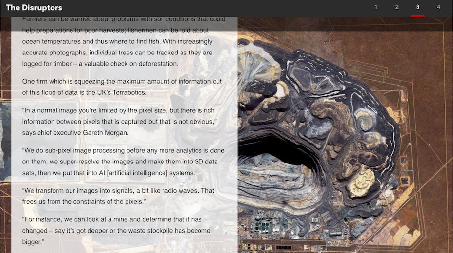
BBC article on the new commercial #Space race. #EarthObservation #Geospatial #RemoteSensing #MachineLearning 🚀 🛰 🌎 🤖=💡 x.com/tbotics/status/9079184…
13 Sep 2017

BBC The new space race: "squeezing maximum amount of information out of this flood of data is the UK’s Terrabotics" bbc.in/2eVqiBB
9
11
22 Jul 2024
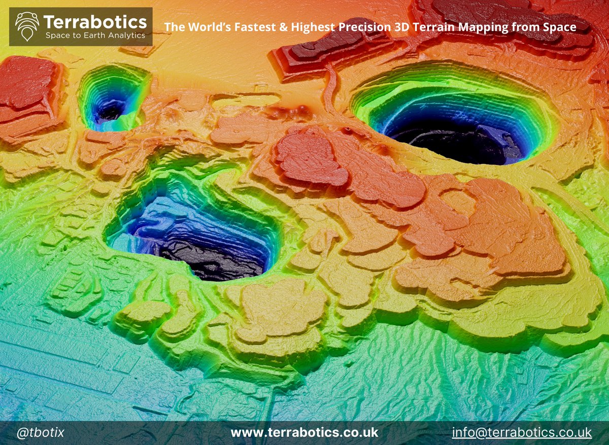
🛰️TBX Minotor™ | MINE SPOTLIGHT ⛏️⚒️
Bełchatów is a large open-pit lignite #coal mine central Poland, producing tens of millions of tonnes of annually
Using 37 years of #Landsat #satellite imagery, we can observe the migration of open-pit mine excavations
#earthobservation
1
121
27 May 2024
@tbotix mentioned in @FT. The era of more transparent, independent, & objective GHG emissions measurement & monitoring is here & only increasing. We’re making sense of this data to bring it down to Earth for action on.ft.com/3UGAql3
2
2
150
Terrabotics 🛰 retweeted

11 Mar 2024
Join for our Emission Measurement and Monitoring Technology Showcase, in partnership with @NSTAuthority.
📅⏰ Thursday 21 March 2024, 13:30 - 17:00
📍 Net Zero Technology Centre, 20 Queen’s Road, Aberdeen, AB15 4ZT
🔗Register: bit.ly/3V7GncD
1
2
222
Terrabotics 🛰 retweeted

6 Feb 2024
🛰️ Edinburgh #EarthObservation firm @tbotix is featured in today's @TheScotsman. @scotent continues to work with the company as it develops its innovative technology, after securing a spot on our #SpaceData for #NetZero challenge ➡️ ow.ly/czyU50QyhpC @scot_business #Space
2
1
604
Terrabotics 🛰 retweeted
8 Feb 2024
🛰️ READ @scot_business' fantastic interview with Anna Dawson of Terrabotics, in which she discusses earth observation data, remote sensing and their huge potential to help businesses reduce carbon emissions ➡️ ow.ly/czyU50QyhpC
@tbotix @TheScotsman #SpaceData #NetZero
1
2
247
25 Jan 2024
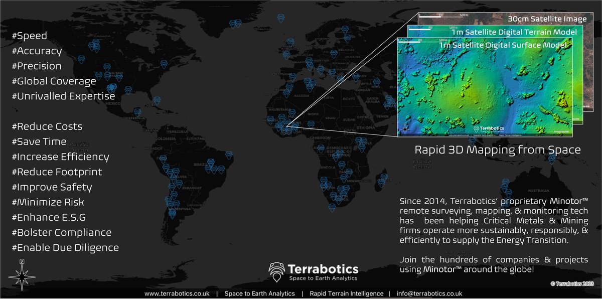
Satellite data provides the most spatially extensive, timely & cost-effective means to produce 3D models and DEMs of the Earth's surface.
Terrabotics' #Minotor™ platform provides ease of access to satellite imagery, 3D data and routine analysis via web bowser or API.
1
2
227
28 Dec 2023
Inspecting the #Darvaza Crater from Space with Satellite-based #methane, #CO2, and #ThermalInfrared #GasFlaring sensors and imagery wix.to/oujIDLN
#Emissions #Crater #GatestoHell #Turkmenistan #GHG #Methane #NaturalGas
3
206
27 Dec 2023
Measure, map & monitor methane emissions like never before! 🛰️🌍🔍💨 Terrabotics' EmissionsAnalyst™ is here to help. Find out more!#ClimateAction #DataAnalytics #Innovation #GHG #Methane #Satellites #EarthObservation #RemoteSensing #Energy #ESG
terrabotics.co.uk/post/terra…
2
5
274
4 Dec 2023
Terrabotics Secures New Funding from @Space4Europe and @spacegovuk to Enhance Energy SCOUT™ Project wix.to/RwnWgph
🛰️🤖🌎🛢️
#energy #renewableenergy #shale #emissions #EarthObservation #RemoteSensing #Geospatial
2
5
225
4 Dec 2023
Terrabotics Secures New Funding from ESA and UK Space Agency to Enhance Energy SCOUT™ Project wix.to/RwnWgph wix.to/RwnWgph
1
2
111
1 Dec 2023
🛰️☀️#SolarEnergy asset monitoring from space! 50 km south of the #COP28 host city of Dubai is the Mohammed bin Rashid Al Maktoum Solar Park. The Solar Park is due to be the largest single-site solar park in the world!
#renewableenergy #solarpower #satelliteimagery #sentinel2
1
2
8
1,045
21 Nov 2023
🛰️ ⛰️ #Satellite-derived DEMs can provide an unparalleled view of the Earth’s constantly evolving and dynamic #topography
Check out this @felt map to explore how Terrabotics satellite intelligence helped track over 9000 sand dunes in Wahibas, Oman!
felt.com/map/Wahibas-Sand-Du…
4
130
8 Nov 2023
Excited for #UserDriven #EarthObservation imaging satellite MANTIS gearing up for launch on #Transporter9 #SpaceX. Terrabotics will transform raw pixels into true user value. Watch this space! #DigitalAlchemy
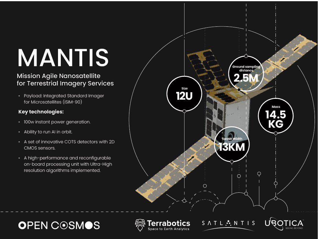
7 Nov 2023

Our high-performance satellite, MANTIS, is gearing up for launch on #Transporter9. It hosts an advanced optical payload for #EO missions along with on-board #AI for instant insights.
Stay tuned for updates on the Vandenberg Space Force Base liftoff! 🛰️
#SpaceX #SatelliteTech
6
272
10 Oct 2023
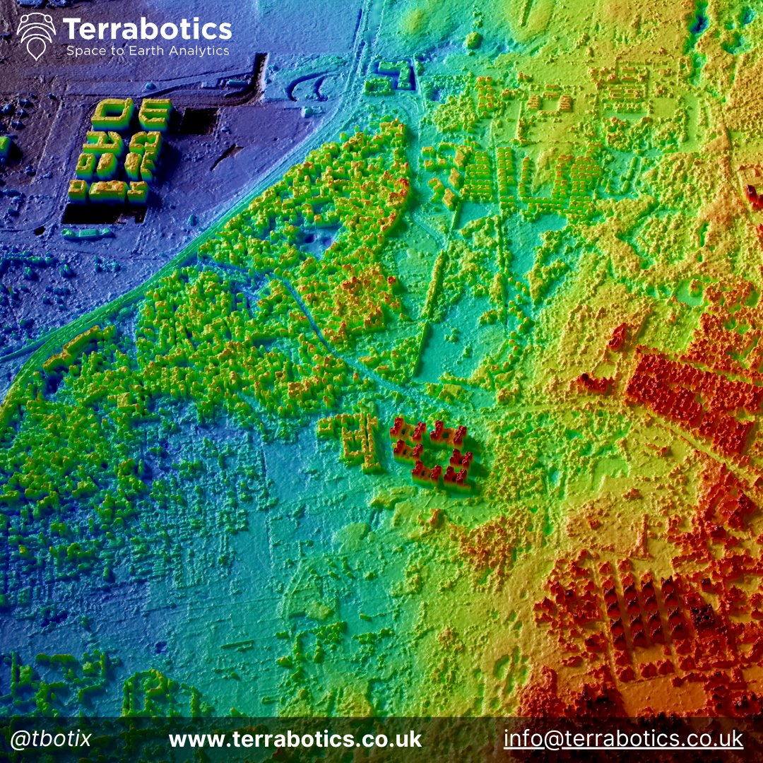
Terrabotics is helping 3D map urban areas from space!
Precision DEMs are an effective and powerful tool for mapping infrastructure, vegetation cover and terrain over hundreds of square kilometers.
#surveying #geomatics #EarthObservation #planning #Risk #transportation #maps
1
1
199
4 Oct 2023
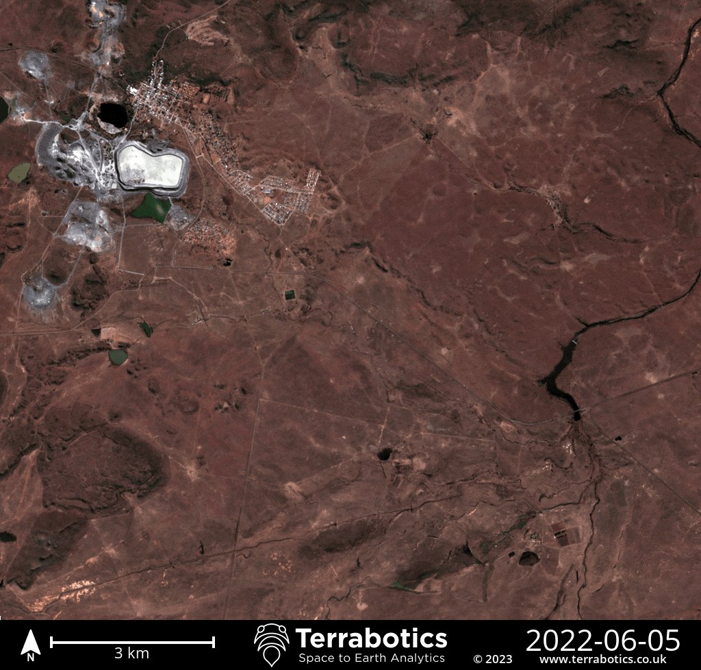
The Jagersfontein tailings dam collapse in September 2022 produced a 7.5 km long mudslide
Terrabotics has developed a tailings dam database to map, measure and routinely monitor tailings dams around the world
terrabotics.co.uk/mining
#Mining #ESG #Satellites #EO #floodrisk
1
1
157
17 Sep 2023
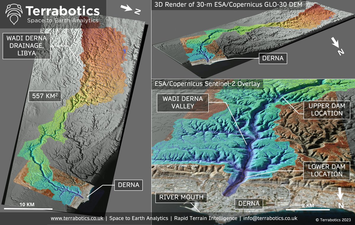
Upstream catchment and valley of the recently flooded Wadi #Derna river, #LibyaFloods, to visualise terrain and drainage networks (ESA/#Copernicus GLO-DEM and #Sentinel2)
Satellite-derived #DEMs are key to planning, #hydrology and engineering to protect downstream populations
2
4
460
8 Sep 2023
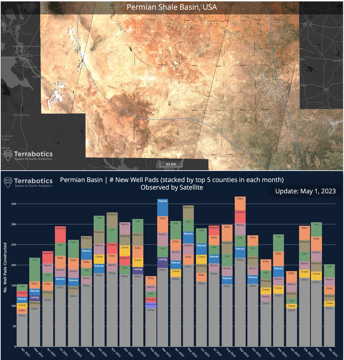
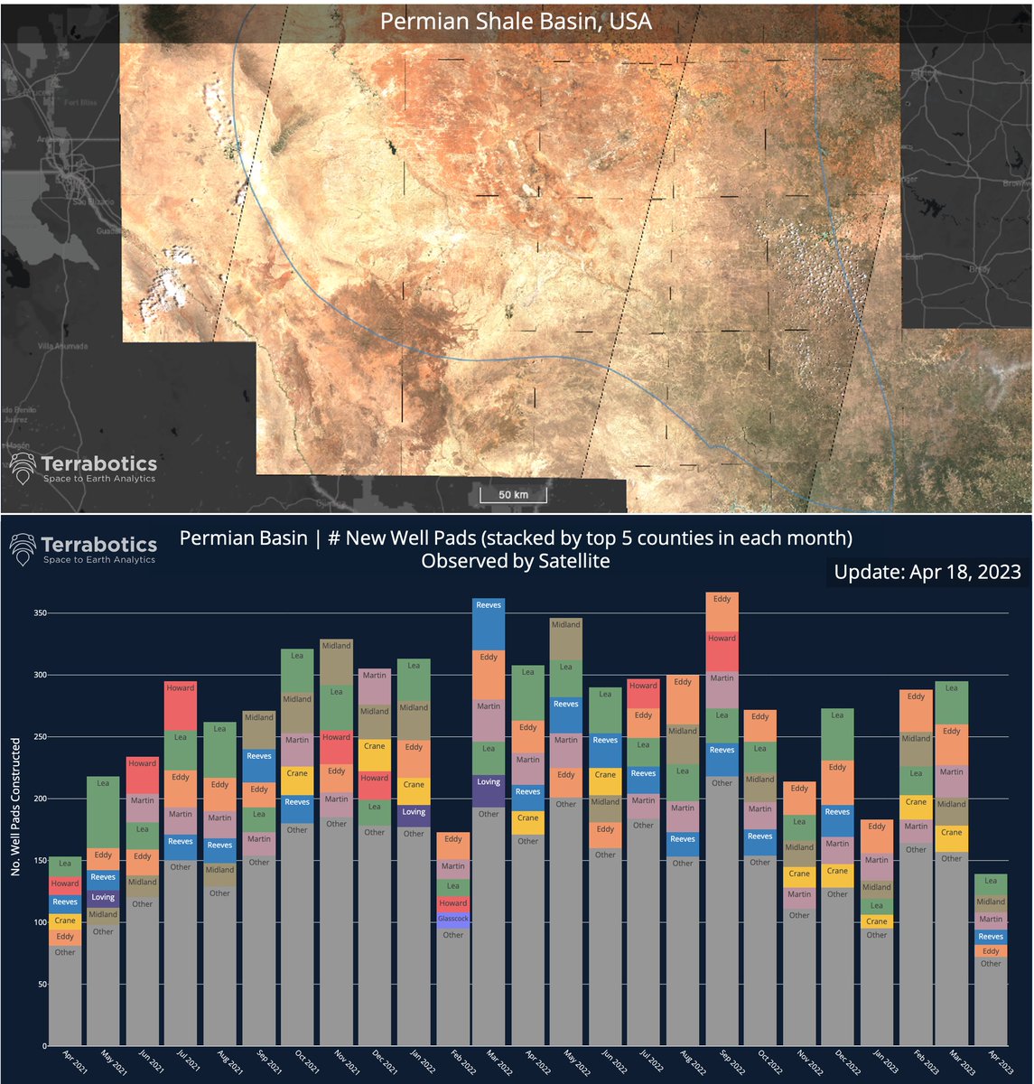
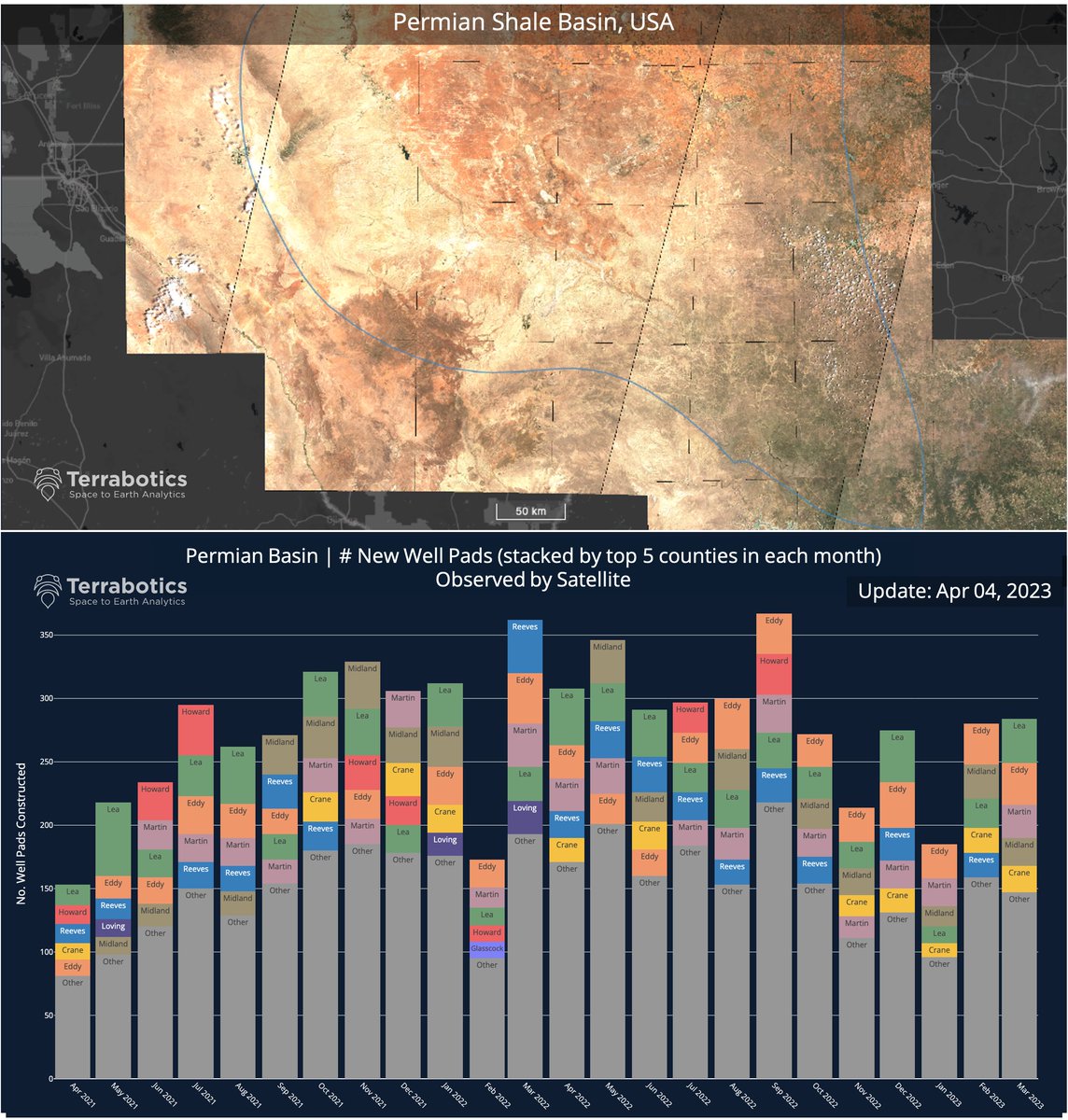
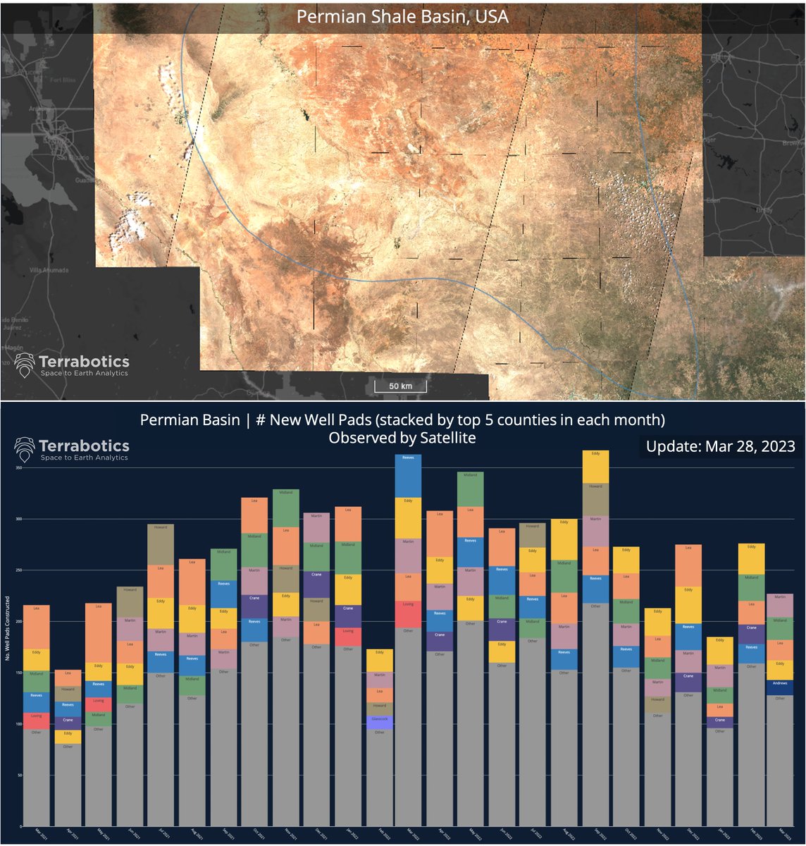
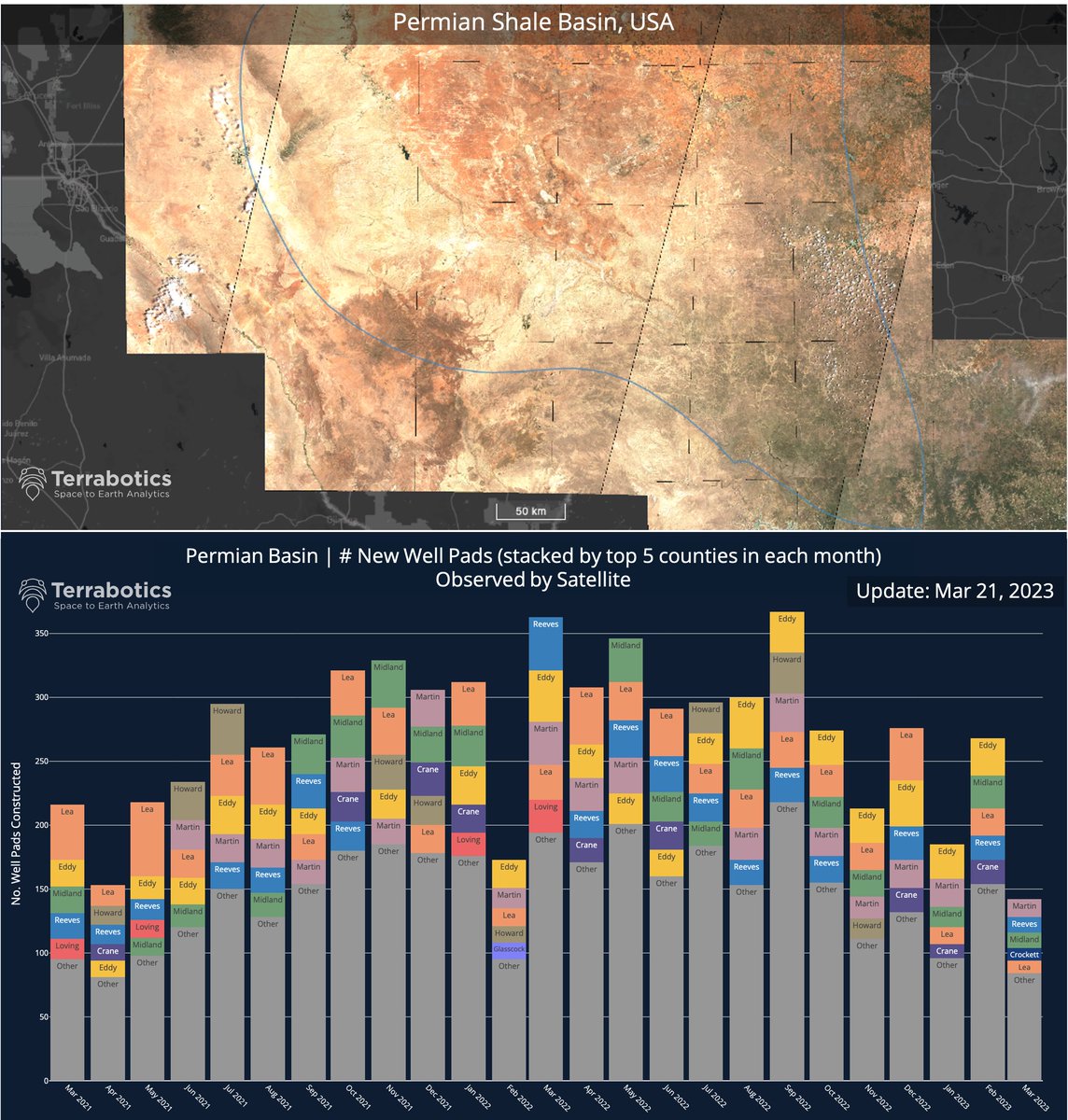
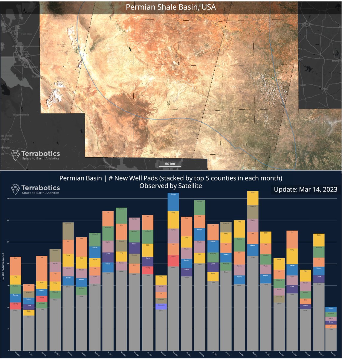
Get a bird's-eye view of your operations with #ShaleAnalyst. Our satellite-image-based system tracks key oil & gas events over a complete pad life cycle, giving you a comprehensive understanding of energy sector performance. #Satellite #energyinsights #AI #datadriven #shalemarket
1
2
155
25 Jul 2023
Another week & another #mining customer helped by our expert team & tech to successfully reduce costs, save time, improve safety, enhance ESG compliance, & maximise #situationalawareness for planning their mining project! 🎉 #westafrica #earthobservation #satelliteimagery
ALT Terrabotics' mining terrain mapping and intelligence projects around the globe. Join 100s of customers using Terrabotics' proprietary rapid 3D mapping service to reduce costs, improve safety, and increase efficiency!
1
1
4
325
Terrabotics 🛰 retweeted

14 May 2023
Our Fragile Space, an exhibition from photographer Max Alexander, focuses on the impact of the millions of pieces of cosmic waste circling Earth newscientist.com/article/mg2…
2
10
37
49,428