
Science is only a tweet away. Tweets do not = endorsement: on.doi.gov/pgwu0Y
Joined April 2008
- Tweets 27,763
- Following 94
- Followers 766,334
- Likes 1,790
Photos and videos

Team USA’s opener may last 90 minutes but understanding landscape change can take decades.
SoFi Stadium in Southern California will host Team USA’s opening match. These aerial photographs show the surrounding landscape’s transformation over time from the former Hollywood Park Racetrack to the stadium and entertainment district seen today.
Historical aerial photographs provide a window into the past, helping scientists and communities see how land use, infrastructure, and natural systems have evolved over time.
Good luck, Team USA! 📷
📹: Historic and current aerial photographs compare the same location over time, showing the landscape's transformation.
1
20
26
6,688
Better data. Faster insights. Smarter decisions.
At the roundtable on water, agriculture, technology, and public data hosted by @TheGrandFarm in North Dakota, Dr. Andrea Travnicek, Assistant Secretary for Water and Science at the U.S. Department of the Interior, spoke about the future of water data.
“The U.S. Geological Survey continues to transform how the nation collects and shares water information by modernizing its publicly accessible data system and working with partners to test cutting-edge tools and approaches that make water monitoring faster, more accurate and more efficient. These advances will deliver more timely and reliable data to enhance flood protection, better inform water supply planning, and support the next generation of agricultural innovation, like that happening here in North Dakota.”
At USGS, reliable water information remains essential for supporting communities, agriculture, and economic growth.
📷: Dr. Andrea Travnicek and Jon Hortness, USGS Acting Regional Director Midcontinent and Northeast Region, join regional stakeholders at the Grand Farm Innovation Campus. Credit: Emerging Prairie

1
26
11
6,404
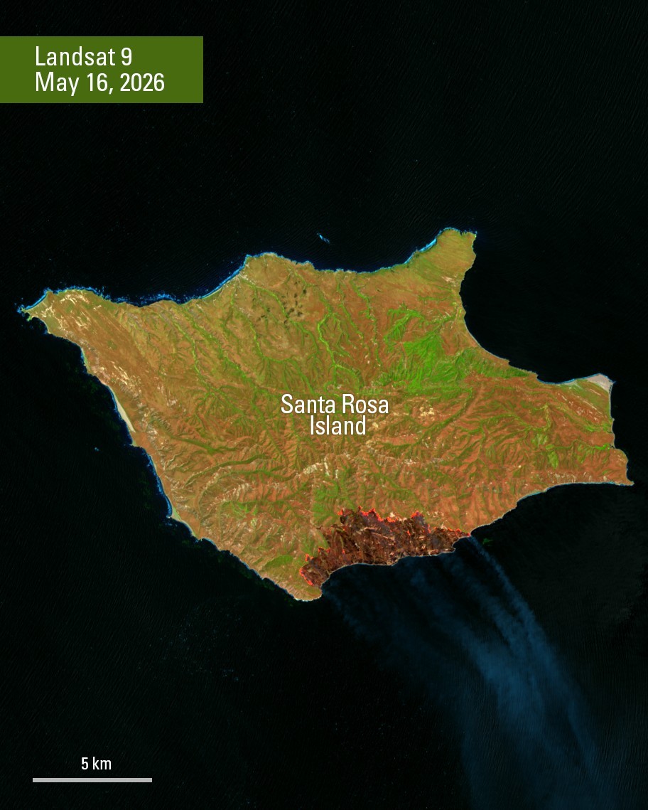
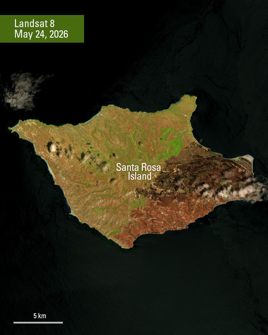
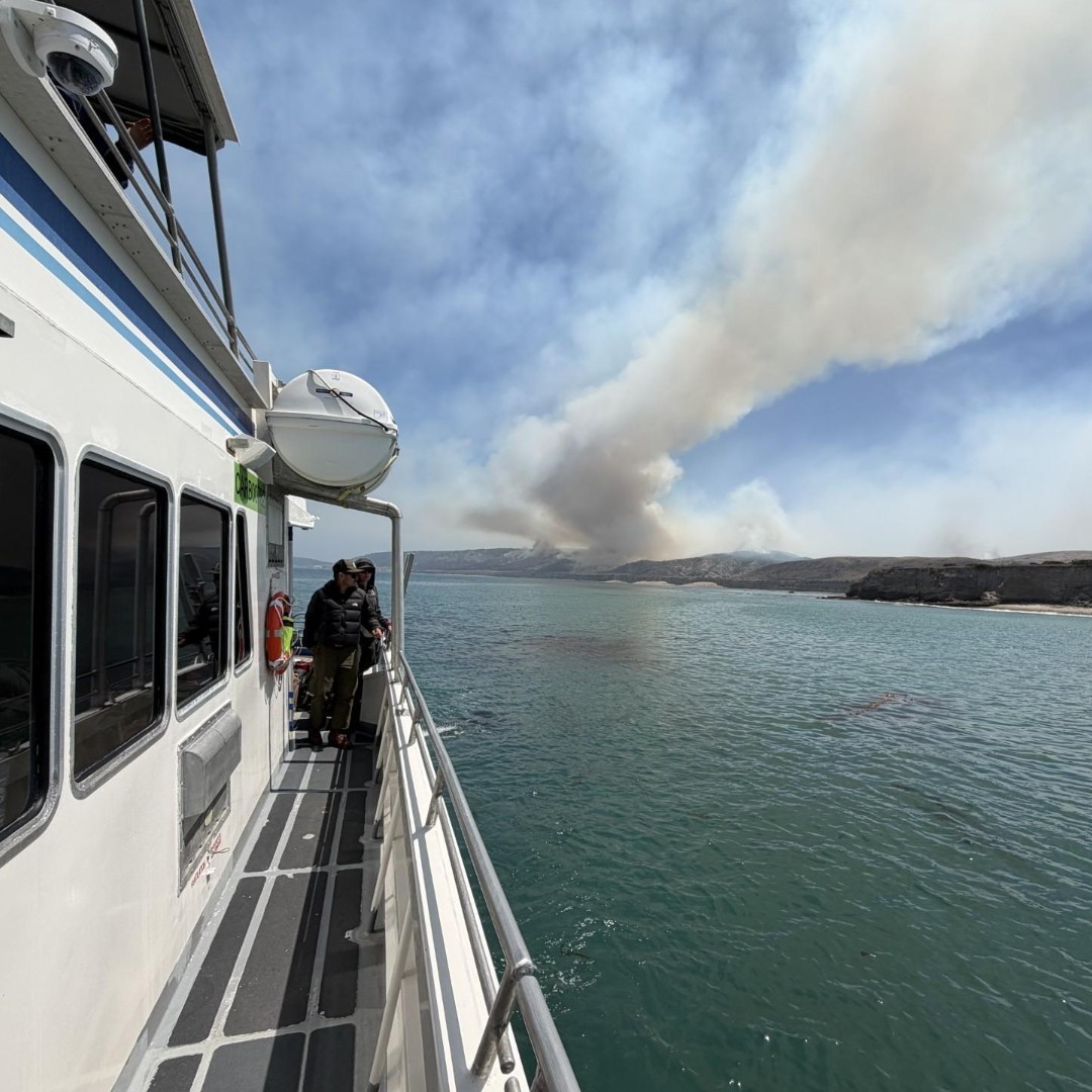
Landsat satellite imagery captures the progression of the Santa Rosa Island Fire 🔥
These Landsat images show the progression of the Santa Rosa Island Fire on Santa Rosa Island, part of Channel Islands National Park off the coast of California. By May 24, the fire had burned more than 18,000 acres across the island’s southeastern terrain, leaving a large, dark burn scar visible from space.
Landsat data are used during and after wildfires to map burned areas, monitor fire progression, assess vegetation damage, evaluate erosion risks, and support long-term ecosystem recovery efforts.
The long-term @USGS/@NASA Landsat record also helps scientists study changing fire patterns and landscape resilience over time. These observations support land managers and fire agencies as they respond to wildfires and assess impacts across affected landscapes. Through the U.S. Wildland Fire Service, federal agencies coordinate wildfire response, risk mitigation, and burned-area rehabilitation across more than 500 million acres of Interior-administered and Tribal lands.
📸 1: Landsat 9 image acquired May 16, 2026, showing active fire fronts and smoke rising from the southeastern portion of Santa Rosa Island shortly after the wildfire was reported.
📸 2: Landsat 8 image acquired May 24, 2026, showing the extensive burn scar left by the Santa Rosa Island Fire across the southeastern end of the island as containment efforts continued.
📸 3: A water scooping aircraft drops water on the Santa Rosa Island Fire on May 19. Photo Credit: J Foye / U.S. Wildland Fire Service
📸 4: A boat transporting firefighters to the Santa Rosa Island Fire arrives to the island. Photo Credit: J Foye / U.S. Wildland Fire Service
@USWFS @USGSLandsat

16
34
7,068
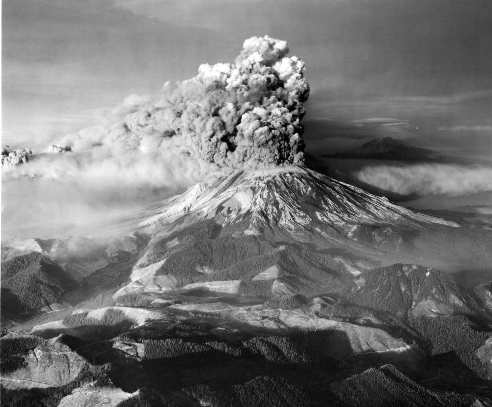
🌋 46 years ago today, Mount St. Helens forever changed the Pacific Northwest — and the science of volcano monitoring.
After more than a century of quiet, earthquakes and rising magma signaled that pressure was building beneath the volcano in the spring of 1980. On the morning of May 18, the mountain’s north flank collapsed in a massive landslide, triggering a devastating lateral blast that flattened 230 square miles of forest.
Ash rose high into the atmosphere and drifted across the U.S, while volcanic mudflows, known as lahars, surged through nearby valleys to the Columbia River. Fifty-seven people lost their lives, including USGS volcanologist David A. Johnston.
When the eruption ended, Mount St. Helens stood nearly 1,300 feet shorter than before. The eruption transformed not only the landscape, but also how scientists monitor and prepare for volcanic hazards around the world.
➡️ Watch USGS scientists recount their experiences before, during, and after the eruption: ow.ly/bX0250Z0V4G
📸: Mount St. Helens erupting above a quiet rural landscape, with ash and steam billowing into the sky. Mount Adams can be seen in the background.
11
226
755
24,904
A river of lava glowing in the dark, captured from space 🌋
Landsat satellites, a joint mission between @Nasa and @USGSLandsat, don’t always take the night off. By special request, they can collect nighttime imagery that helps scientists monitor erupting volcanoes, wildfires, glaciers at twilight, and more.
This nighttime image from Landsat 9 captured Mauna Loa’s 11.3-mile-long lava flow on December 4, 2022, illuminating a plume of ash in the atmosphere above Hawaii. Swipe to see how it looked from the ground the next day.
Want to know what a certain volcano, wildfire, or icy landscape looks like after dark from space? Learn more about what Landsat can see at night and how to submit a special imagery request 👉ow.ly/sprg50YZJ3E


7
36
132
8,663
Don’t forget the flowers this Mother’s Day 💐
This American pika may look like it’s carrying a bouquet, but it’s actually gathering plants for its winter food stash in the mountains.
Pikas spend the warmer months collecting grasses, wildflowers, and other vegetation to store for the colder season ahead. Like moms everywhere, always gathering, planning ahead, and making sure everyone has what they need.
Happy Mother’s Day from the USGS!
📸: American pika eating plants. Credit: USGS

3
17
95
6,939
USGS retweeted

Apr 30
Day one of the Tribal Energy Summit concluded with a Federal Partners Panel. ⚡️
Officials from @EPA, @DOIONRR, @USGS, @PermitCouncil and @Interior discussed how the Trump administration is working across the government to cut red tape, improve coordination, and build tribal capacity to speed up the process of converting resources to revenue so that tribes can invest in their communities.

ALT A collage of photos of federal partners presenting at the Tribal Energy Summit in Houston today.
3
12
18
6,240
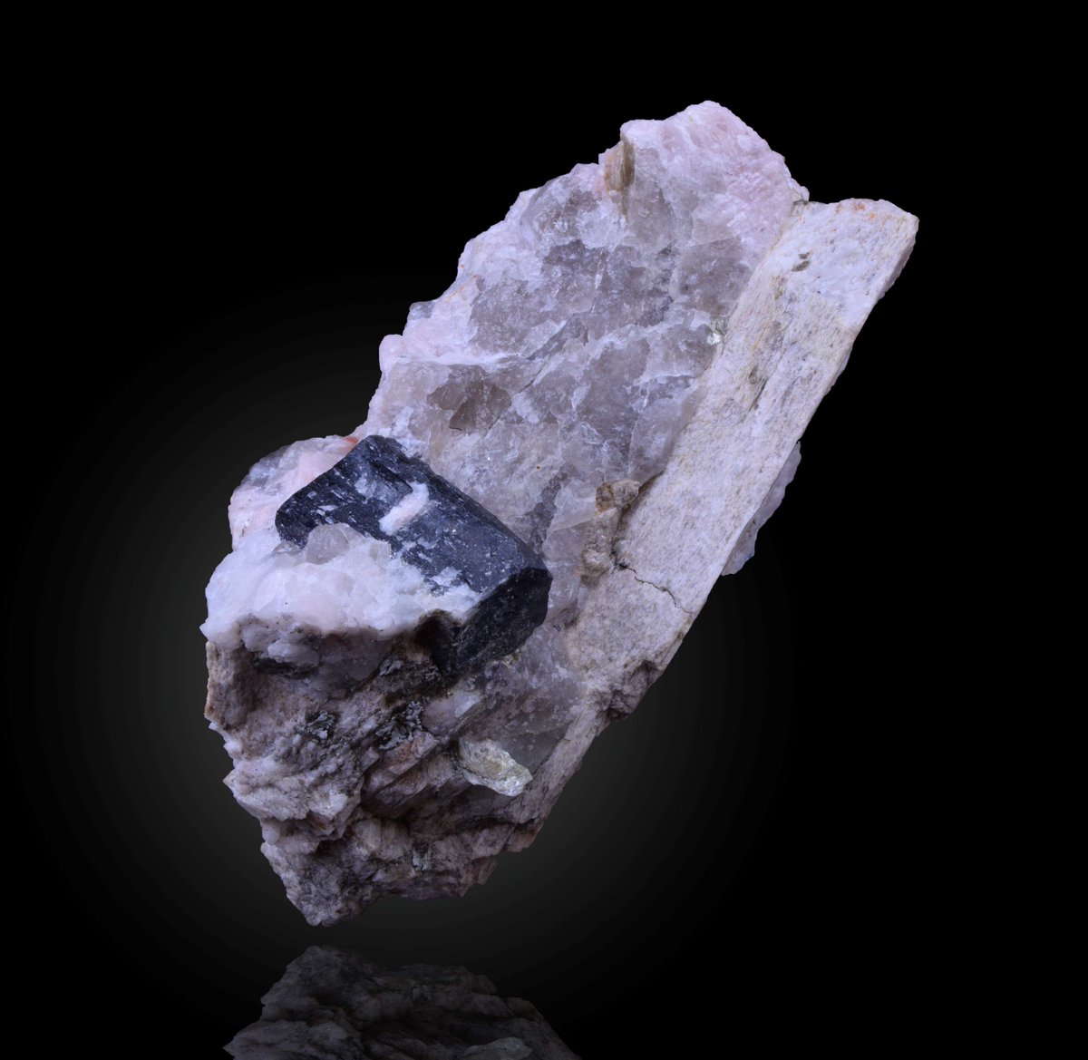
A new USGS assessment estimates that the Appalachian region of the eastern U.S. contains 2.3 million metric tons of undiscovered, economically recoverable lithium. That's enough lithium to replace 328 years of imports!
Lithium is essential for batteries that power EVs, energy storage systems, electronics, and military technologies. The U.S. still relies heavily on foreign supply, and this research shows that the Appalachians contain enough lithium to help meet the nation's growing needs.
Read more about what this geologic assessment means for U.S. supply: ow.ly/V73e50YRhJg
📸: Lithium in pegmatite, with tantalum (black)
100
355
1,453
135,069
From 1,400 books to one of the world’s largest Earth science collections 📚🌎
When the USGS was established in 1879, the library started with just 1,400 books—supporting early efforts to explore and understand the nation’s landscapes.
Today, it has grown into one of the most comprehensive Earth science collections in the world:
📖 1.5 million volumes
🗺️ 750,000 maps
📷 500,000 historical photos
📝 30,000 field records
Whether you’re tracing the history of a volcanic eruption, studying water resources, or exploring decades of fieldwork, the USGS library has resources that can help.
During National Library Week, we recognize the USGS Library and libraries everywhere for preserving knowledge, supporting discovery, and connecting generations of science.
Explore the collections 👉 ow.ly/Y1es50YPsMc
📷1: USGS library reading room in the Interior Building, Washington, D.C. 1935.
📷2: USGS library in the Hooe Building, Washington, D.C. 1917.
📷3: USGS library display of the world-famous George Frederick Kunz library of gems and precious stones. Washington, D.C. 1935.
#NationalLibraryWeek


1
21
86
8,115
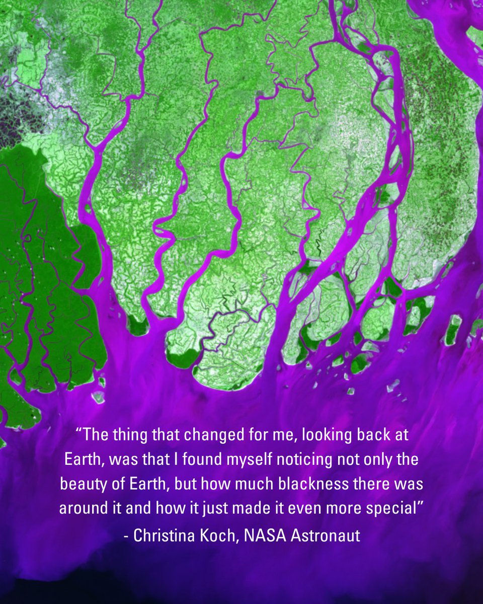
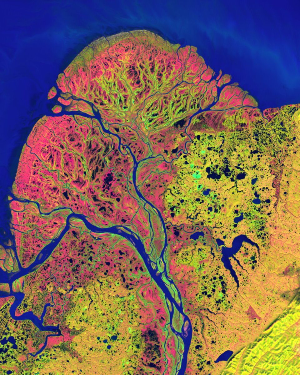
Happy Earth Day 🌎🌿
Earth is truly a beauty to behold, as seen in these stunning images captured through the USGS/NASA Landsat program. We capture these satellite images to create a long, continuous record of Earth’s land surface so we can monitor and understand how the planet is changing over time.
Artemis II astronaut, Christina Koch, described her powerful experience of viewing our planet from space and what that meant to her.
On Earth Day we are reminded of just how breathtaking the place we call home truly is.
Images from the Earth As Art collection: ow.ly/BR2n50YObEb
📷1: The Ganges River forms an extensive delta where it enters the Bay of Bengal. The delta is largely covered with swamp forest known as the Sundarbans, which is home to the Royal Bengal Tiger.
📷2: The Yukon River flows from northern British Columbia through Yukon, Canada, and Alaska, USA, before emptying into the Bering Sea. In the Yukon Delta, countless lakes, sloughs, and ponds are interconnected across one of the largest river deltas in the world.
📷3: Sediment in the Gulf of Mexico off the Louisiana coast forms layered patterns of color in the water. River outflow carries sediment into the Gulf, creating complex swirling textures.
#EveryDayIsEarthDay

14
71
7,400
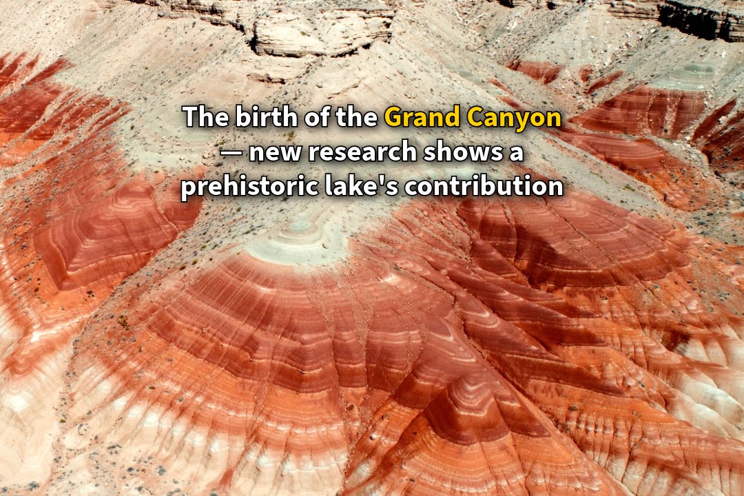
How a prehistoric lake helped carve the Grand Canyon 💧
Scientific discussion about the formation of the Grand Canyon began in 1869, with an expedition led by John Wesley Powell, a pioneering geologist and future director of the USGS. Powell navigated the Colorado River by boat, advanced early theories about the canyon’s origins and demonstrated the national need for a dedicated science agency—work that ultimately contributed to the creation and mission of the USGS.
That legacy of exploration continues today, as researchers uncover new insights into the Grand Canyon’s origins.
A new collaborative study led by the USGS provides strong evidence that the Grand Canyon was carved out by spillover flooding from ancient Lake Bidahochi, a large lake fed by the ancestral Colorado River. The lake’s eventual spillover likely helped establish the course of the Colorado River.
Beginning about 6.6 million years ago, the sand within these lake deposits shows a clear and distinct Colorado River signature. Two million or so years later, evidence indicates the river system had fully integrated, connecting headwaters in the Rockies all the way to the Pacific through the Gulf of California, thus carving what is now the Grand Canyon along the way.
Learn more about the study here: ow.ly/hjhG50YLeSR
📷: At Greasewood mesa the contrast between the dark red mudstone beds and the tan sand-dominated layers above marks the arrival of Colorado River sediment into the Bidahochi basin 6.6 million years ago. Photo by Brian Gootee, Arizona Geological Survey. Any person(s) wishing to conduct unmanned aerial vehicle flights on the Navajo Nation must first apply for and receive a permit from the Navajo Department of Transportation.
1
22
51
6,658
Discover the geology beneath your feet 🔍🌍
The ground you walk on holds more than just rocks. It holds stories.
Geoheritage identifies geologic features that shape our landscapes and our history, culture, and identity as a nation. These places help us understand Earth’s past and how it affects us today.
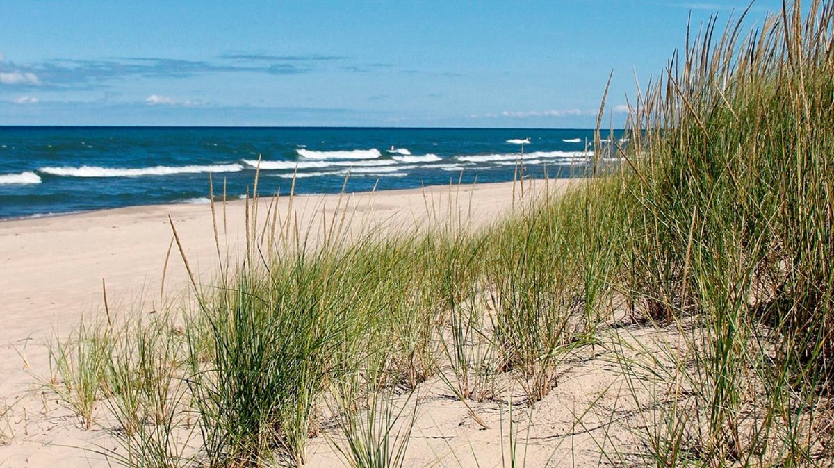
From the columnar basalt formations of Devils Postpile National Monument to dunes shaped by wind and glacial sands at Indiana Dunes National Park, these sites show how geologic processes shape the land and how people study and use it.
USGS scientists study and share these places to support research, education, and public understanding.
🎉 This month marks one year since the Geoheritage Sites of the Nation Explorer launched. Celebrate with us by exploring this interactive tool to find geoheritage sites across the country: ow.ly/jq8Z50YJ58N
📷1: Vertical columns of basaltic volcanic rock at Devils Postpile National Monument are formed when a thick lava flow slowly cools. Credit: USGS
📷2: Marram grass growing out of the sand near the shoreline in West Beach at Indiana Dunes National Park. Credit: NPS

3
7
80
11,150
USGS retweeted

Apr 10
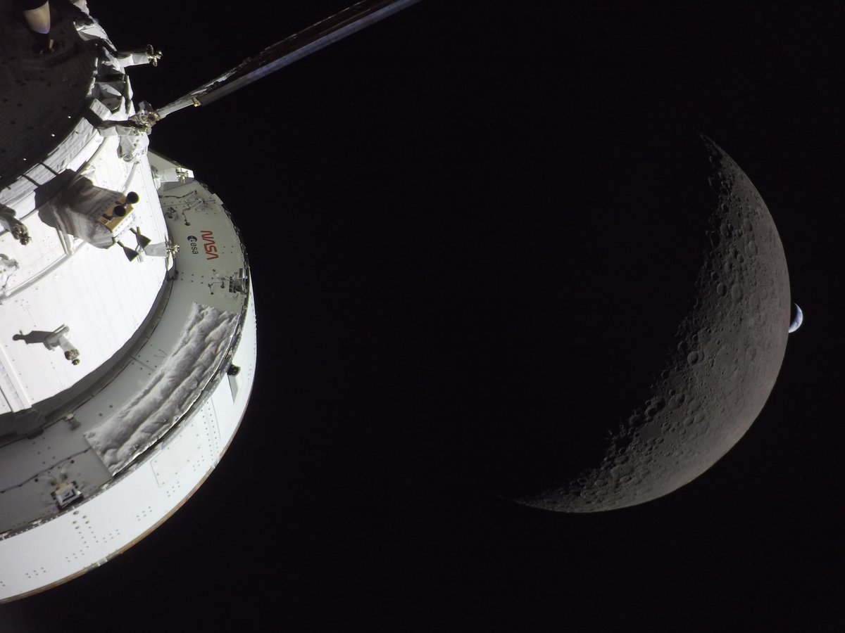
T-minus 3 hours until you might hear and feel sonic boom(s) in southern California from Artemis II re-entry! The sonic boom is expected at ~5-5:15 pm Pacific time today, April 10. Share your experience using our Did You Feel It survey so we can understand the spatial extent of the boom: earthquake.usgs.gov/earthqua…
📸Earthset captured through the Orion spacecraft window at 6:41 p.m. EDT, April 6, 2026, during the Artemis II crew’s flyby of the Moon. (NASA)
17
158
561
36,004
USGS retweeted
Apr 9
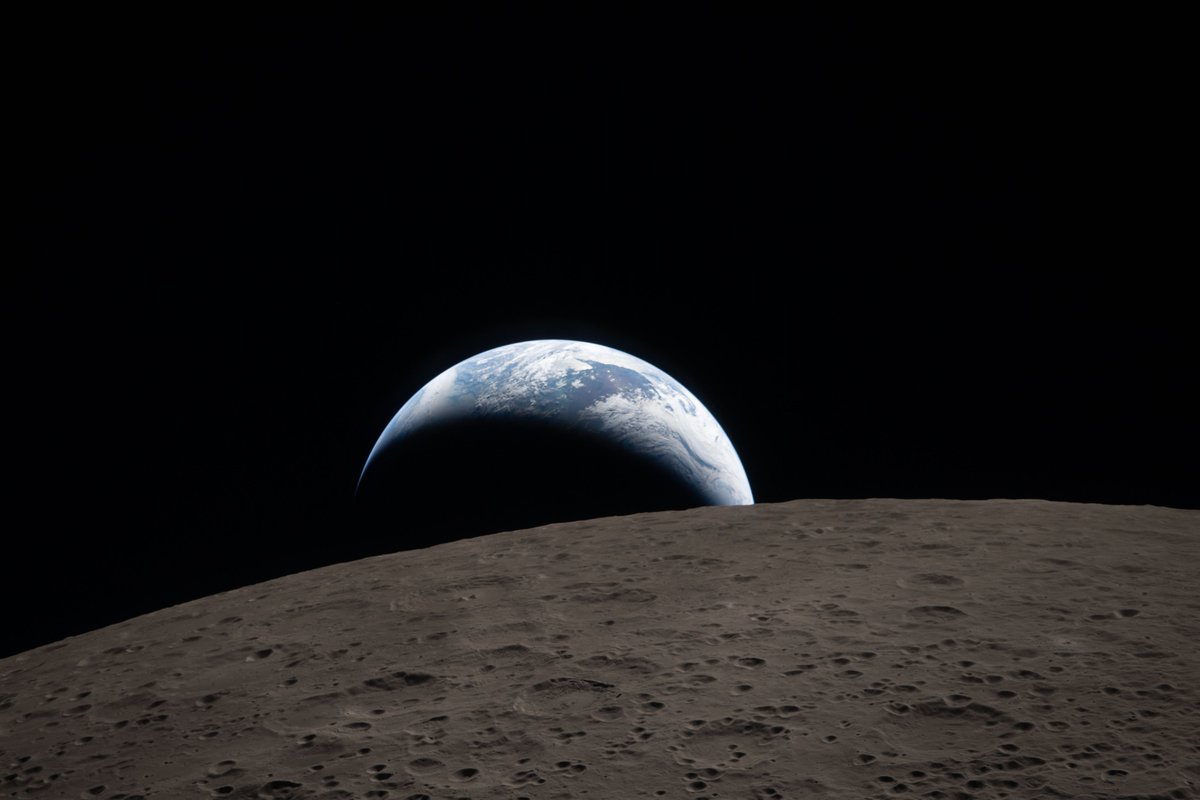
🌑Artemis II is nearing its return to Earth🌎
A sonic boom is expected as the spacecraft re-enters the atmosphere and could potentially be felt and heard throughout Southern California between 5:00 and 5:15 pm local time tomorrow, April 10.
If you hear or feel sonic booms (or not), please fill out this "Did You Feel It" survey.
earthquake.usgs.gov/earthqua…
📷: NASA’s Orion spacecraft captures the Moon and the Earth in one frame during the Artemis II crew’s deep space journey at 6:42 p.m. ET on the sixth day of the mission.
ALT Close-up of a spacecraft module orbiting near a crescent moon with Earth faintly visible in the background.
33
484
2,611
189,021
The Moon, revealed through its geology. 🌗
Explore the Unified Geologic Map of the Moon! Created by @usgs_astrogeo, in collaboration with @nasa and other partners, this first-ever comprehensive map reveals the Moon’s entire surface geology, combining Apollo-era data with recent satellite missions.
It not only shows the 4.5-billion-year history of our lunar neighbor, but also serves as a key tool for future human missions and an invaluable resource for scientists, educators, and space enthusiasts.
Download the full map and legend 👉ow.ly/yY7l50YAPCY
📹: This animation shows a rotating globe of the Unified Geologic Map of the Moon with shaded topography from the Lunar Orbiter Laser Altimeter (LOLA). Credit: NASA/GSFC/USGS.
#NASA #Moon #GeologicMap
13
349
923
133,555
On the Iditarod Trail, winter conditions can change mile by mile.
River ice thickens and thins. Snow bridges form and collapse. Glaciers shift. What looks solid one day may change the next.
USGS scientists study glacier movement and ice conditions across Alaska to better understand how these winter landscapes behave.
Because when travel depends on frozen rivers and valleys, reading the landscape matters.
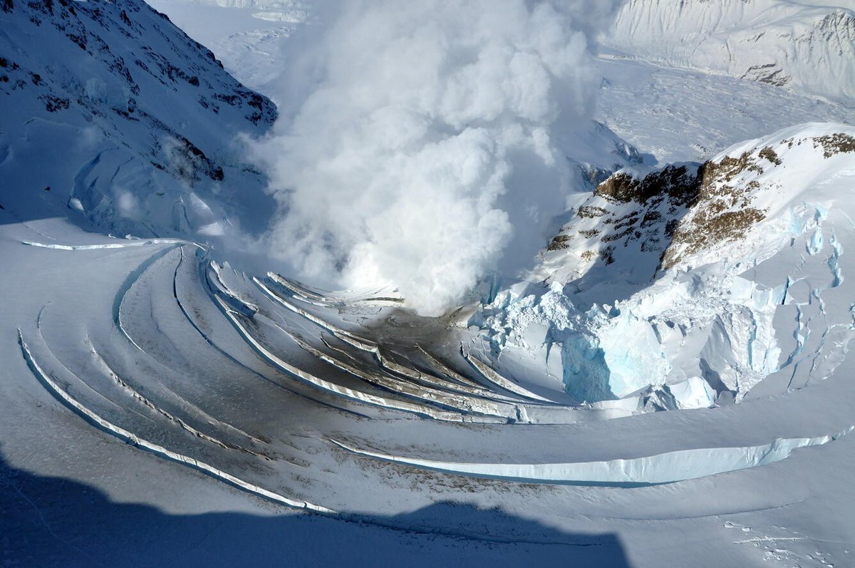
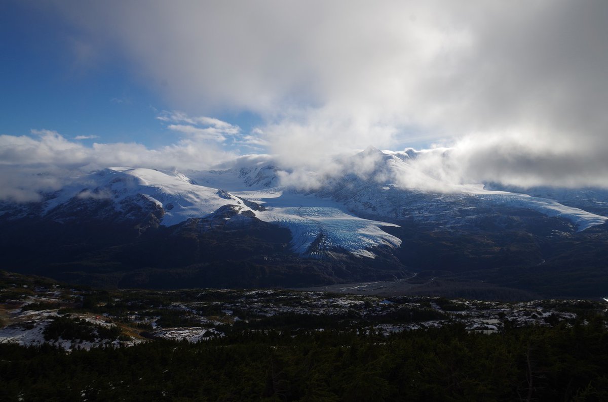
📸 1: Aerial photo showing fracture line of avalanche along a snow ridge line. A reminder of how quickly conditions can shift in steep terrain.
📸 2: Steam rises through fractured ice at Redoubt Volcano, where heat from below reshapes the frozen surface above.
📸 3: View of Nellie Juan Glacier from Wolverine Glacier, where visibility and weather can change in minutes.
Credit: USGS
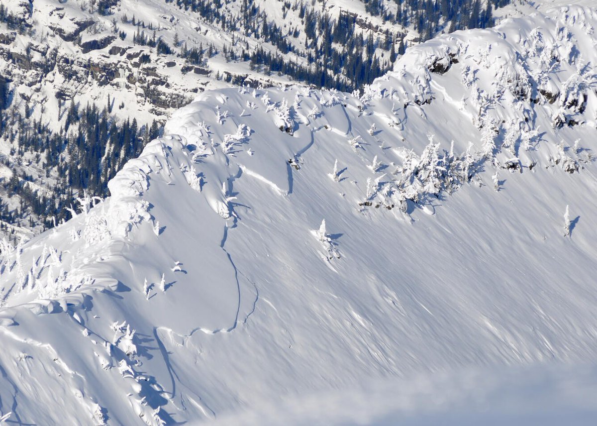
ALT Snowy alpine ridge with scattered snow-laden trees.
ALT Steam rising from a volcanic crater surrounded by snow-covered mountains and icy terrain.
ALT Snow-covered mountain range with a large glacier under a cloudy sky partially revealing blue patches.
4
4
40
7,682
Each March, mushers and sled dogs prepare to travel one of Alaska’s most historic winter routes during the Iditarod Trail Sled Dog Race.
The trail itself isn’t permanent. It takes shape each winter.
The depth, density, and timing of snowpack determine when a winter trail can safely take shape across public lands, including sections managed by the Bureau of Land Management. Small shifts in temperature can mean thinner snow at lower elevations or earlier melt in key sections.
In fact, low snow has forced the Iditarod to move its starting location in 2003, 2015, 2017, and again in 2025.
USGS scientists track snow conditions from satellites and in the field to better understand how Alaska’s winter landscape changes from year to year.
By race day, winter has already built the trail across Alaska’s public lands.
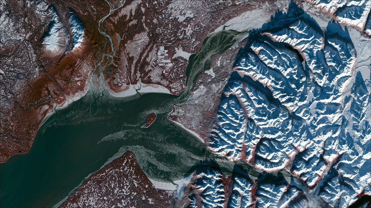
📷: Landsat 9 image of Anchorage, Alaska, captured November 20, 2021.
@BLMNational @BLMAlaska
1
5
44
8,046
Each year, reopening Going-to-the-Sun Road in Glacier National Park depends on daily avalanche forecasting and a decades-long partnership between the U.S. Geological Survey and the National Park Service.
The 50-mile engineering marvel crosses the Continental Divide, connecting the east and west sides of the park.
Since 2003, USGS avalanche scientists have worked side-by-side with the NPS to deliver daily avalanche forecasts that guide “go/no-go” decisions for crews clearing snow and avalanche debris from the road.
Spring conditions in Glacier can change quickly, with sudden snowstorms and avalanches threatening crew safety and slowing progress.
This USGS–NPS partnership ensures road crews have the information they need to work safely and efficiently, saving time and resources while helping the park prepare for the busy season ahead.
The Going-to-the-Sun Road typically opens in late June or early July each year. Visitors can check the park’s website for the latest updates.
1
6
57
7,780
USGS retweeted
Mar 5
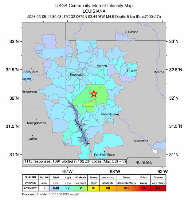
If you're in or near northwestern Louisiana and felt (or didn't feel) the earthquake on the morning of March 5, please let us know!
earthquake.usgs.gov/earthqua…
7
56
173
16,197
USGS retweeted

Hydrothermal explosions at Norris Geyser Basin...earthquakes...ground deformation...geyser eruptions...
It's all in the latest Yellowstone Volcano Observatory monthly video update!
youtu.be/aMNlRpbu5MI
@YellowstoneNPS
2
16
91
27,197