Felt today's earthquake? Test your earthquake knowledge with our True or False quiz! 🧠
After the quiz, visit BeReadyUtah.gov for emergency preparedness resources and kit checklists.
Utah is earthquake country—are you ready?
#KeepingUtahSafe#BeReadyUtah
#Prepare: What if Utah's #water stopped working?
No water 🚱 = no toilets, no handwashing, #disease outbreak risk.
Learn more from Be Ready Utah, @UtahDEQ, @UtahDHHS.
👀 Check out our interview to see what to prepare for—and what to do NOW.
#KeepingUtahSafe#earthquake
Salt Lake County search and rescue coordinator shares what hikers DON'T think about in fall/winter. New interview up now. Know the warnings. Know your limits.
Aviso de Inundación Repentina incluye Kane County, UT hasta la 1:30 PM MDT
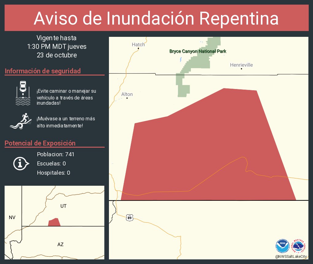
ALT Este gráfico muestra la localización en el mapa de un aviso de inundación repentina. El aviso estará en efecto hasta la 1:30 PM MDT. El aviso incluye a Kane County, UT. El aviso incluye el oeste del condado de Kane en el sur de Utah. ¡Evite caminar o manejar su vehículo a través de áreas inundadas! ¡Muévase a un terreno más alto inmediatamente! Hay 741 personas bajo este aviso incluyendo 0 escuelas y 0 hospitales.
🚨 What do State EOC activation levels mean?
🔵 5 (Blue): Normal ops
🟢 4 (Green): Local can handle
🟡 3 (Yellow): Multi-agency help
🟠 2 (Orange): Large-scale, state/fed support
🔴 1 (Red): Full activation, major incident
🥶 A Freeze Warning is in effect tonight into Tuesday morning for Eastern Box Elder County and portions of the Northern Wasatch Front as temperatures drop near to below freezing overnight. Take action now to protect sensitive plants, people, pets, and pipes! #utwx
ALT A graphic detailing a freeze warning for the northern Wasatch Front and eastern Box Elder County. Take action now to protect sensitive plants, people, pets, and pipes.
❄️Did you know snowstorms can hit any time of year?
In Oct. 1984, a lake-effect storm dropped nearly 2 feet of snow on the Salt Lake Valley — shutting down schools, roads & power. ⚡🚗🏫
Don’t get caught off guard! Stay prepared year-round 👉 @BeReadyUtah 💪
*Major Risk of Flash Flooding Through Saturday Evening Across Southern Utah* Those with outdoor plans in flood prone areas should strongly consider alternate plans. Avoid backcountry roads and please remember, turn around, don't drown. Do not drive across flood roads. #utwx
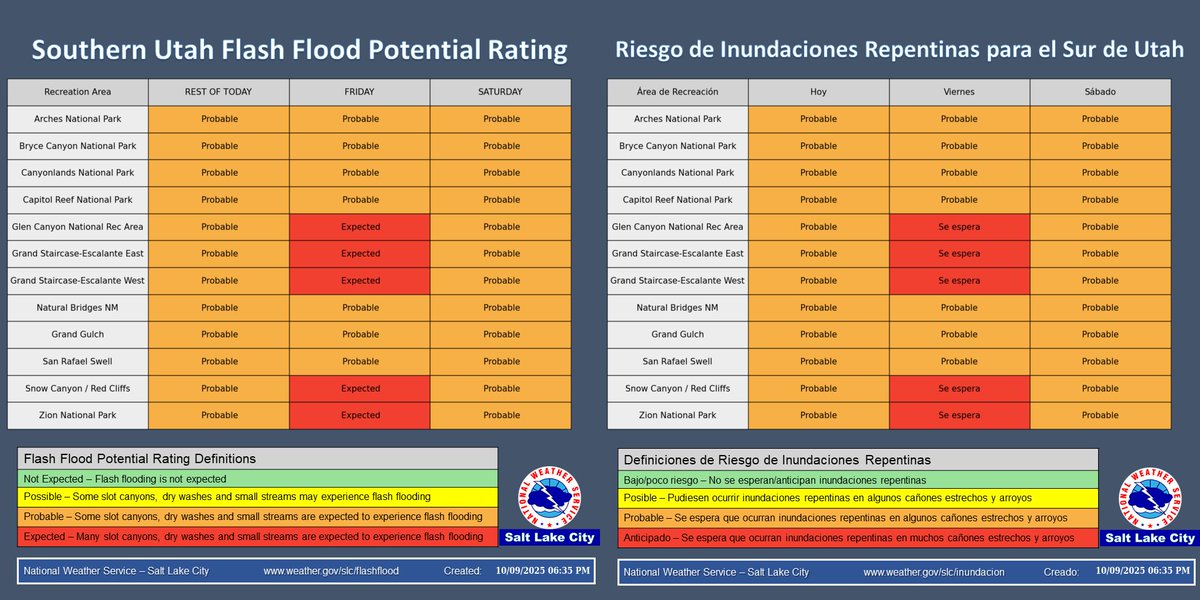
ALT Image showing a widespread threat of flash flooding across southern Utah through Saturday evening.
⚠️⛈️ With increasing confidence in widespread heavy rain, the Flash Flood Potential Rating has been upgraded to Expected in parts of S-UT on Friday. This potential will increase rapidly during the early morning hours and will continue through the day and into Saturday. #utwx
⚠️Heavy rainfall has prompted a Flash Flood Warning for Zion National Park, including Zion Canyon. Seek higher ground now if in this area and never drive across flooded roads! #utwx
Flash Flood Warning including Springdale UT and Rockville UT until 5:30 PM MDT
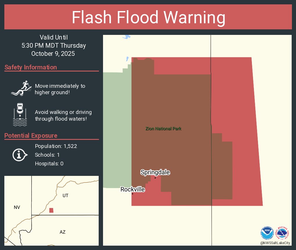
ALT This graphic displays a flash flood warning plotted on a map. The warning is in effect until 5:30 PM MDT. The warning includes Springdale UT and Rockville UT. This warning is for West Central Kane County in southern Utah, East Central Washington County in southwestern Utah and Specifically Zion National Park. Avoid walking or driving through flood waters! Move immediately to higher ground! There are 1,522 people in the warning along with 1 school and 0 hospitals.
A Flood Watch is in effect for much of southeast Utah and southwest Colorado this evening through Saturday evening. Rainfall rates in excess of in inch per hour and widespread amounts over 1 to 2 inches for this event could lead to excess runoff in many vulnerable areas!
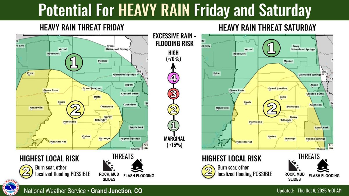
ALT Potential for heavy rain Friday and Saturday. The highest local risk lies across southeast Utah and southwest Colorado where burn scars and other localized flooding is possible. Rock/mud slides may also occur from excess runoff along steep terrain.
⚠️A Flood Watch is in effect for much of central, southern, and eastern Utah beginning Thursday afternoon through Saturday night. An influx of tropical moisture will result in widespread heavy rain across the area, leading to an increased threat of flash flooding. #utwx
Remnant tropical moisture will push into the area late Thursday. This moisture will linger through Friday before interacting with a cold front on Saturday that will bring widespread precipitation to most of the area. Flash flooding is possible across sensitive areas. #utwx#wywx
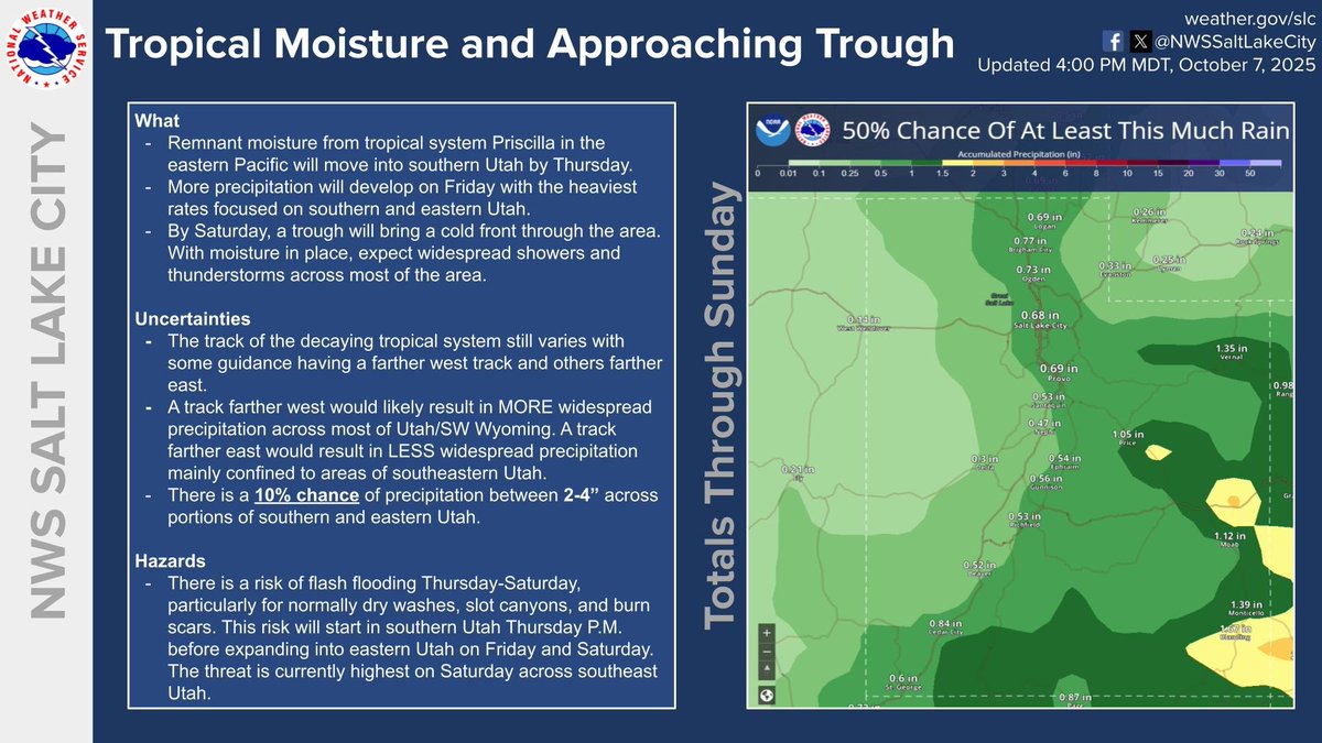
ALT Graphic showing a map of precipitation totals along with key bullet points for the upcoming storm.