
Daily Weather Updates And Live-Streams. Check Out My Youtube! youtube.com/@connorsclimatec…
Joined October 2024
- Tweets 786
- Following 31
- Followers 1,250
- Likes 127
356 Photos and videos


Connor's Climate Corner retweeted
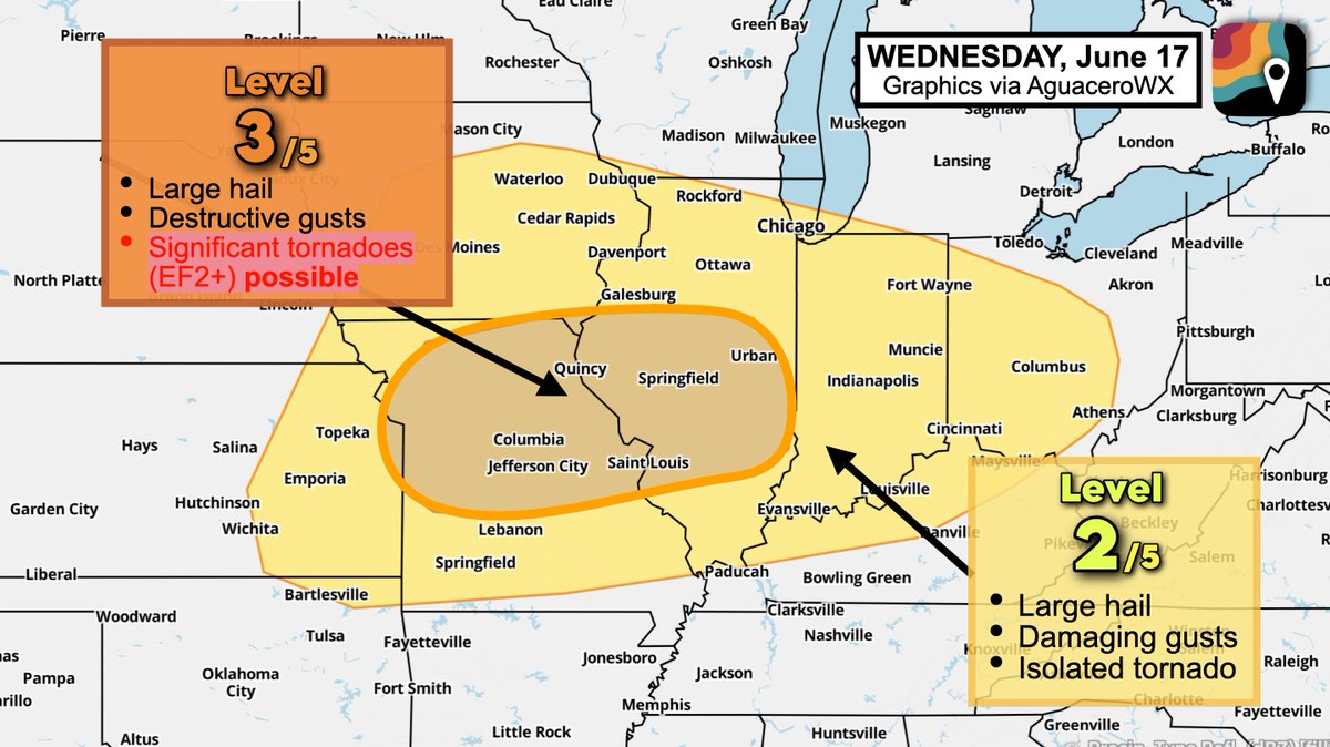
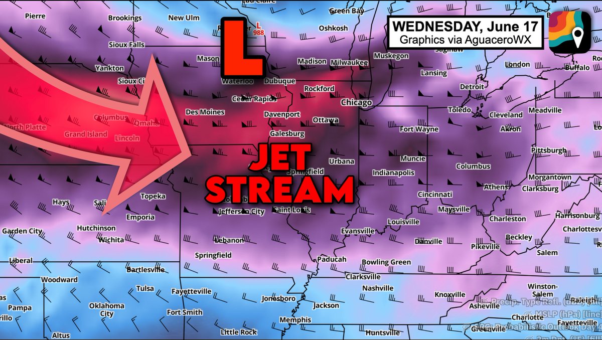
WEDNESDAY, June 17 may feature yet another upper-echelon severe weather event across the Midwest. A few significant (EF2 ) tornadoes are possible.
We're especially watching Missouri and Illinois, although parts of the Corn Belt are at risk too, as well as areas all the way to Ohio.
A few of the storms that form may produce destructive gusts (70 mph), tornadoes (some EF2 ) and hail. Areal coverage remains uncertain.
Low pressure passing through Minnesota will pull warm, humid air northwards. That will provide ample instability, or thunderstorm fuel.
A powerful jet stream, exceptional for June standards, will swing overhead, adding plentiful wind energy to the equation. Robust wind shear, or changing winds with height, will encourage storms to rotate.
It's likely there will be some morning downpours/storms as a warm front lifts through. It's unclear how quickly those appetizer storms will exit east.
The warm front will introduce rapid heating and "air mass recovery," once again juicing up the lower atmosphere for the main round of afternoon storms along the cold front.
We don't know what "storm mode" will dominate. Will we get a squall line with widespread destructive gusts and a few quick-hitting, brief tornadoes? Or will we see rotating supercells with a greater tornado risk? TBD.
For now, we ask you to stay tuned. We'll keep you updated.

5
40
344
21,915

Severe Storms Today, Bigger Threat Looms This Week... youtu.be/9u8kZhrki_4?si=e6O4… via @YouTube
2
53
Connor's Climate Corner retweeted

Jun 12
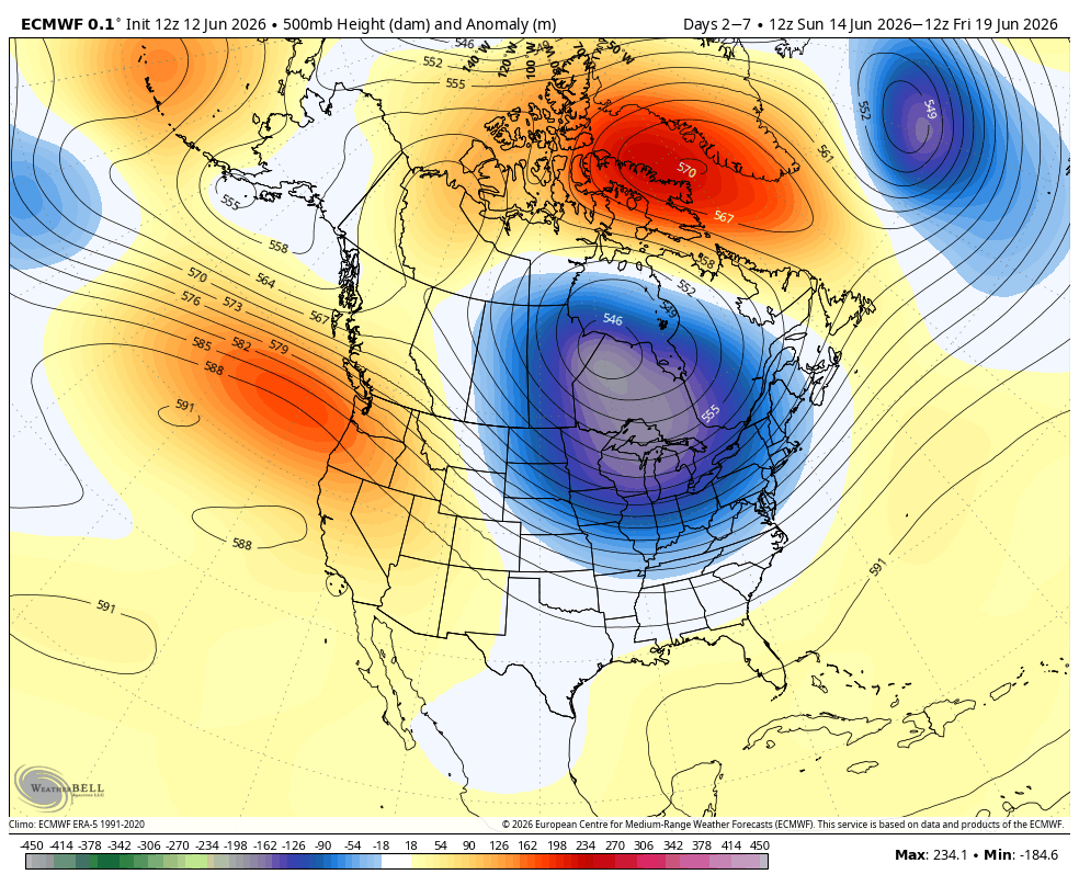
Interesting weather pattern coming next week.
6
10
102
9,129
Connor's Climate Corner retweeted

Jun 11
A TORNADO OUTBREAK with strong-to-violent tornadoes possible is about to begin across eastern Iowa into northern Illinois. Stay tuned to severe weather watches and warnings in the outlined target area

9
79
542
35,875
Connor's Climate Corner retweeted

Jun 11
A tornado watch has been issued for parts of Illinois, Indiana, Iowa, Missouri and Wisconsin until 9 PM CDT
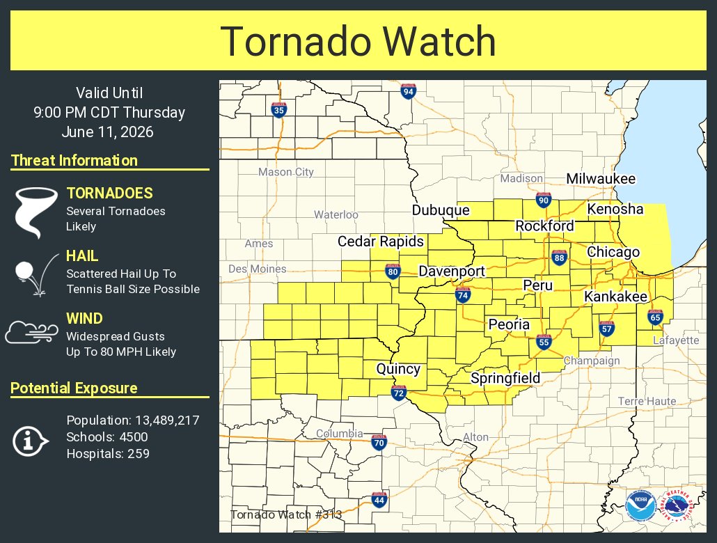
ALT This graphic displays Tornado Watch watch number 313 plotted on a map. The watch is in effect until 9:00 PM CDT. The watch includes parts of Illinois, Indiana, Iowa, Missouri and Wisconsin. The threats associated with this watch are several tornadoes likely, scattered hail up to tennis ball size possible and widespread gusts up to 80 mph likely. There are 13,489,217 people in the watch along with 4500 schools and 259 hospitals.
15
188
544
69,836
Connor's Climate Corner retweeted

Jun 11
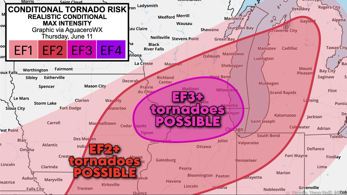
We have a volatile parameter space across northern Illinois.
Incredible shear for June standards. Robust fuel will be present.
But we still don’t know if supercells will exist to take advantage.
High ceiling, low floor. QLCS likely too. Details:
2
9
92
6,380
Connor's Climate Corner retweeted

8:00am CDT #SPC Day1 Outlook Moderate Risk: across eastern Iowa and northern Illinois spc.noaa.gov/products/outloo…

34
344
1,335
220,621
This Severe Weather Threat Just Escalated | 60% Wind Risk
youtu.be/nRTgZUI0BY8?si=jTdK… via @YouTube
1
4
369
I wake up 3-4 times a week at 4-5am to record edit and post weather content before going to my 9-5 job. I have 2 kids so it’s generally the only time I have to create content.
My videos have been averaging a low 100-300 views.
This bothered me for a period of time and I’ve seriously considered quitting.
But if I’m being honest, I don’t feel I would love weather and meteorology as much if I wasn’t sharing it with people. I wouldn’t get excited about it if I wasn’t engaged with my community and the weather community in general… Whether that be 5 people or 5 thousand people.
To anyone who has ever engaged with my content. Thank you! 🙏🏻
11
44
3,981
Connor's Climate Corner retweeted
Jun 10
After mulling it over, I think I'm comfortable adding a zone Thursday where – conditionally – the atmosphere could support an EF3 (intense) tornado.
That's predicated on one or more supercell structures emerging within a broader batch of thunderstorms, which remains uncertain.
33
91
1,094
91,416
Connor's Climate Corner retweeted
Jun 10
Things Are Getting DANGEROUS With The Weather..
youtu.be/c9vj9f97ID4
1
2
11
2,465
Connor's Climate Corner retweeted

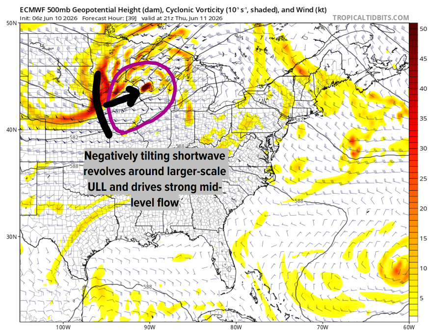
Jun 10
Tomorrow looks to be the most concerning day of our multi-day Midwest severe outbreak. A potent shortwave will pivot through the region, generating a focused zone of ascent in which a surface cyclone will rapidly develop. This will induce intense, veering winds throughout...(1/2)
1
4
67
6,307
SIGNIFICANT Severe Weather Threat Growing Across the Midwest...
youtu.be/e1W3AKS28IA?si=qXUk… via @YouTube
2
7
2,166
Hell yeah brother… Don’t forget to take some good pictures of the capping and clear skies!☀️

On my way to choose the wrong target today and miss an amazing show. 😀
2
133
I work a 9–5.
The amount of discipline it takes not to spend all day combing through model data on a significant severe weather day like today is unbearable.
My brain just wants to analyze soundings, compare severe parameters, track boundaries, and stare at radar.
This is torture.
It’s like locking a kid outside a candy store and telling him he can’t even look through the window.😭
9
325
Connor's Climate Corner retweeted
Jun 9
A swing of the trough with impulses of energy with it will drive a very active stretch of severe weather for the rest of the work week.
Once we get into the weekend onward, the trough hits chungus level & digs & broadens. This will create an active pattern for next week across many areas of the country but will be highlighted for areas further to the South & East I believe compared to the areas the severe weather has been & will be over the next couple of days.
The trough will bring in a significant cooldown that will have the most impacts across the middle of the country. The Deep South & up the East coast will likely not feel the cool down as much if at all due to the position of the trough.
Later in the month, the trough weakens allowing for the storm track to return more so North.
Trough is the blue area you see in the animation below.
3
9
82
4,423
Severe Weather Marathon: 5 Consecutive Days of Threats...
youtu.be/8p2-DhMH62M?si=QZtS… via @YouTube
3
189
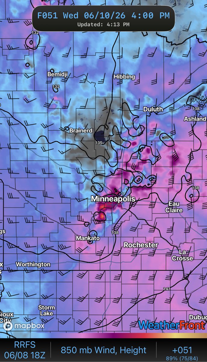
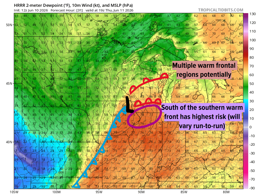
Minnesota 🚨 🚨
Wednesday has my attention 👀
The latest 18z RRFS (take this model with a grain of salt - It loves to over convect) continues to advertise a potentially significant severe weather setup across parts of Minnesota Wednesday afternoon/evening.
The environment may support strong tornadoes, large hail and damaging winds.
The wind threat looks particularly noteworthy right now.
Storm/MCS initiation could occur near MSP or just east of the metro, which would have major implications for who sees the highest-end threat.
Lots of time for adjustments, but definitely a forecast worth watching.
#msp #minnesota #severeweather #twincities

1
10
782
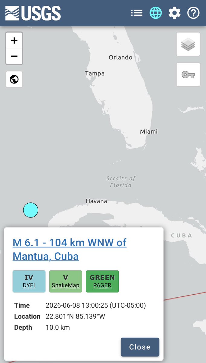
BREAKING 🚨🚨
A reported M6.1 earthquake just occurred off the coast of Cuba that could be felt in Florida…
2
333

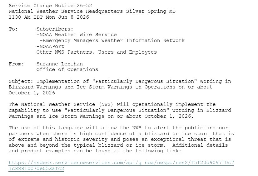
The National Weather Service will implement "Particularly Dangerous Situation" wording in Blizzard Warnings and Ice Storm Warnings beginning October 1, 2026.
#wxtwitter
14
87
529
36,038