
I forecast significant weather in DC & the Mid-Atlantic. GMU and PSU alumnus, Cat dad and Photographer. Instagram: dc_storms
Joined May 2021
- Tweets 9,815
- Following 717
- Followers 1,256
- Likes 8,714
788 Photos and videos


🇺🇸DC⚡️Storms retweeted

While we’ve been enjoying the calmer conditions today compared to Thursday and Friday, another severe weather threat exists tomorrow afternoon and evening.
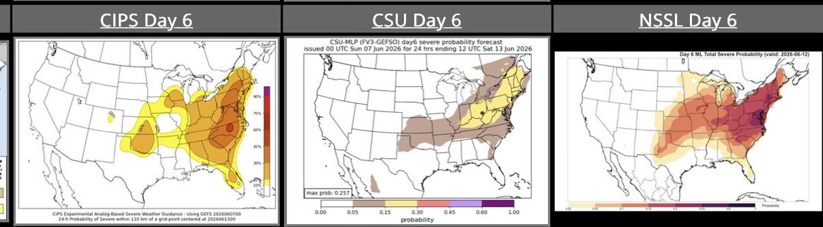
Storms tomorrow may also be intense similar to previous days. The entire region is once again under a Level 2 out of 5 risk for severe storms.
Damaging winds are the primary threat, with gusts of 60-70 mph possible in stronger storms. However, large hail and an isolated tornado or two will also be possible.
Make sure to stay aware tomorrow and have several ways to get alerts. #vawx #mdwx #dcwx #wvwx


4
11
62
7,157
🇺🇸DC⚡️Storms retweeted

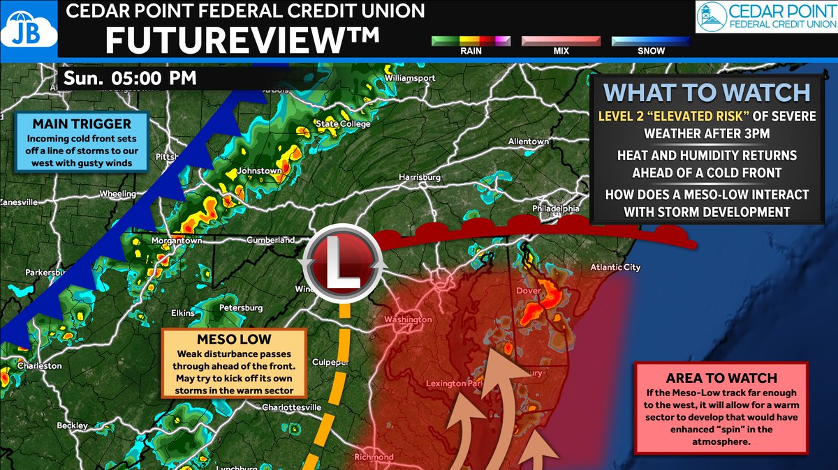
After a quiet and comfortable Saturday, the atmosphere will quickly become more favorable for severe thunderstorms on Sunday. A cold front approaching from the west will interact with a return of heat, humidity, and strong winds aloft, creating an environment capable of producing scattered severe thunderstorms after 2-3 PM and continuing into the evening hours.
The primary threat will be damaging wind gusts of 60-70 mph, which could bring down trees and power lines. While damaging winds are the main concern, a few storms may become supercellular and could also produce isolated hail and a brief tornado. The Storm Prediction Center has placed the region in a Level 2 of 5 "Elevated Risk", with some indications that portions of the Mid-Atlantic are nearing Enhanced Risk criteria if storm coverage and organization become more widespread. Even still, this does not appear to be a widespread severe weather outbreak.
One of the biggest forecast questions involves a weak area of low pressure (meso-low) developing ahead of the front. If it tracks far enough west, it could allow a warmer, more unstable air mass to surge northward and enhance storm intensity across parts of the region. Regardless of the exact details, Sunday afternoon and evening will be a period to closely monitor weather conditions and have multiple ways to receive warnings.
I will have updates throughout the day tomorrow!
3
4
14
701
🇺🇸DC⚡️Storms retweeted
⛈️ Heads up: Strong to severe storms are possible Sunday afternoon and evening. Damaging wind gusts over 57 mph are the primary threat — a tornado or large hail can't be ruled out.
See CapitalWeather.com for latest thoughts on timing and intensity which could change slightly as we continue to evaluate information into early tomorrow.
Hot and soupy backdrop Sunday: Highs near 90 to mid-90s, feeling as hot as 100° before storms arrive.
📅 Cooler and less humid to start the workweek.
#DCwx #DMVwx #MDwx #VAwx

16
42
323
43,627
🇺🇸DC⚡️Storms retweeted

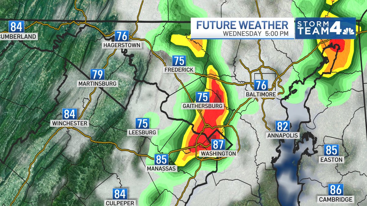
Not set in stone but here is our Fox5DC Futurecast model and the timing of the storms on Sunday @Fox5DC
2
8
43
11,813

🇺🇸DC⚡️Storms retweeted

Jun 12
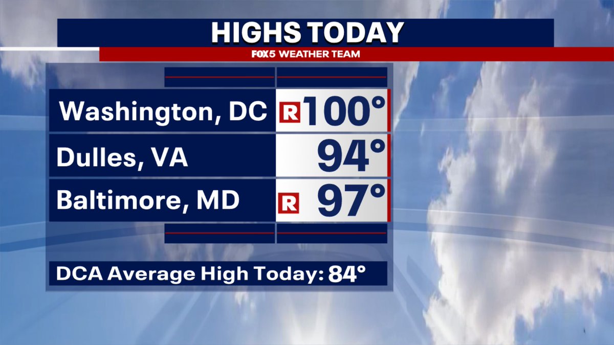
TRIPLE-DIGIT HEAT! 🌡️🔥
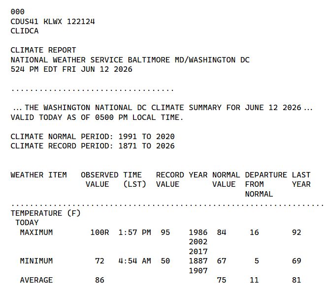
DC hits 100°F this afternoon, setting a new daily record high.
🔥 DC's first 100°F day since August 2024
🔥 DC's earliest 100°F day since 2011 (June 9th)
🔥 DC's peak heat index today was 107°F
🌡️ Baltimore hit 97°F, breaking a record high (96°F) that has stood since 1986.
9
28
1,577
🇺🇸DC⚡️Storms retweeted

Jun 12
DC hit 100 today! First 100 high since August 2024. Beat the record for the date of 95. BWI Marshall/Baltimore also set a record with 97.
Just a few storms around, including another quick-hitter closing on DC. Still a strong to severe storm chance through evening.
6
27
210
26,498
🇺🇸DC⚡️Storms retweeted

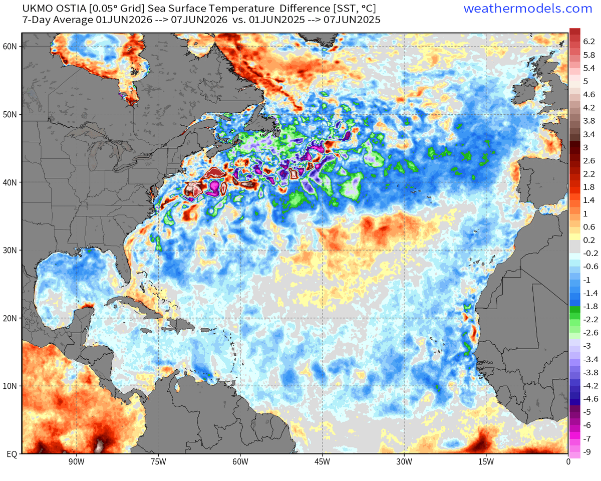
Jun 10
How's the Atlantic Ocean doing these days? Well, it's much, much cooler than last year for the first week of June!
(Met Office OSTIA 0.05°)
11
42
214
21,180
🇺🇸DC⚡️Storms retweeted

Jun 12
Severe Thunderstorm warning for areas in orange, including the Metro area and the I-95 corridor until 8:30pm! Winds could gust over 60mph. Heads up my friends.

3
9
35
5,287
🇺🇸DC⚡️Storms retweeted
Jun 11
Maybe a few morning showers, then VERY hot & humid again Thursday afternoon. While it's unstable, for most of the day we lack a trigger. But notice the storms tonight in the Midwest on Futurecast. It is their "cool air exhaust" the could trigger strong storms here later tomorrow.
1
4
52
10,396
🇺🇸DC⚡️Storms retweeted
Jun 10
Heads up tomorrow afternoon! There could be some strong to severe storms moving through the region. There will also be some showers for the MORNING commute too, so take that umbrella to work! Humidity will be WAY up there, so be ready.
3
38
4,155
🇺🇸DC⚡️Storms retweeted

Jun 9
The new NMME highlights two areas of rather stormy conditions in the U.S. next winter, including the East and West Coasts.
Due to El Niño, a strong subtropical jet stream will probably transport tropical moisture and mild air into the country, with fewer cold spells possible.

4
25
174
9,050
🇺🇸DC⚡️Storms retweeted
OUCH!! First real heat of the summer moving in over the next few days. Thursday will be hot, but Friday should be the hottest day with a Heat Index over 100. There will be a chance of severe storms over the next few days as well.

5
30
156
20,862
🇺🇸DC⚡️Storms retweeted
Jun 9
After a pretty pleasant start to the workweek...heat returns the second half of the week, along with some of the strongest humidity of this season so far. Thunderstorm chances will return as well.
1
4
33
2,812
🇺🇸DC⚡️Storms retweeted

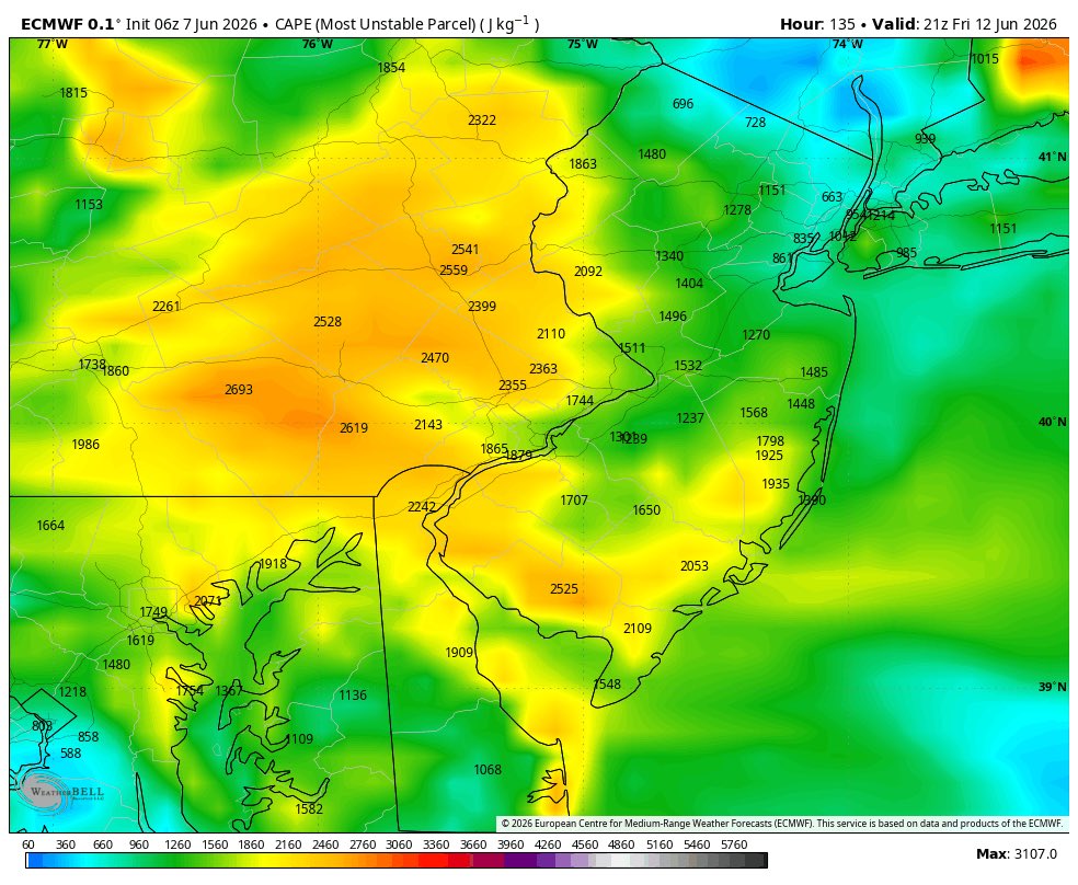
Next severe threat could be Friday. This could be a big one. Strong front coming in with temps feeling near 100 with cape around 2,000. All 3 websites do show a risk for severe weather. Will monitor this through the week. Stay tuned.
2
11
67
9,359
🇺🇸DC⚡️Storms retweeted
Jun 7
When it comes to El Niño, atmospheric changes matter just as much as changes in sea temperatures.
That's because it's a coupled ocean-atmosphere phenomenon.
Looking at velocity potential, which marks areas of rising air (green) and sinking air (brown) in response to warming and cooling tropical seas, a very strong atmospheric El Niño response is forecast during the months ahead — with abundant rising air above the Pacific.
That response is predicted to be similar to or even more intense than past super El Niño events, such as in 2015, 1997 and 1982.
A positive Indian Ocean Dipole is also looking increasingly likely to develop later this year, which would reinforce El Niño's effect by causing yet more sinking air over Indonesia.
However, because warm water is forecast to extend farther west in the Pacific than during the most recent super El Niño events, there may also be more rising air farther west this year. This could influence the weather patterns that this El Niño produces.
The atmospheric response in 2026 is forecast to be much stronger — and markedly different — than in 2023.
These changes in rising and sinking air arise from warm ocean waters shifting from west to east across the tropical Pacific, leading to more thunderstorms in the eastern Pacific and fewer in the west.
This, in turn, influences weather patterns across the globe by altering jet streams and storm tracks, as these thunderstorms release heat into the atmosphere.
Such long-distance links between weather patterns are known as teleconnections.

7
44
178
13,320
🇺🇸DC⚡️Storms retweeted

Jun 4
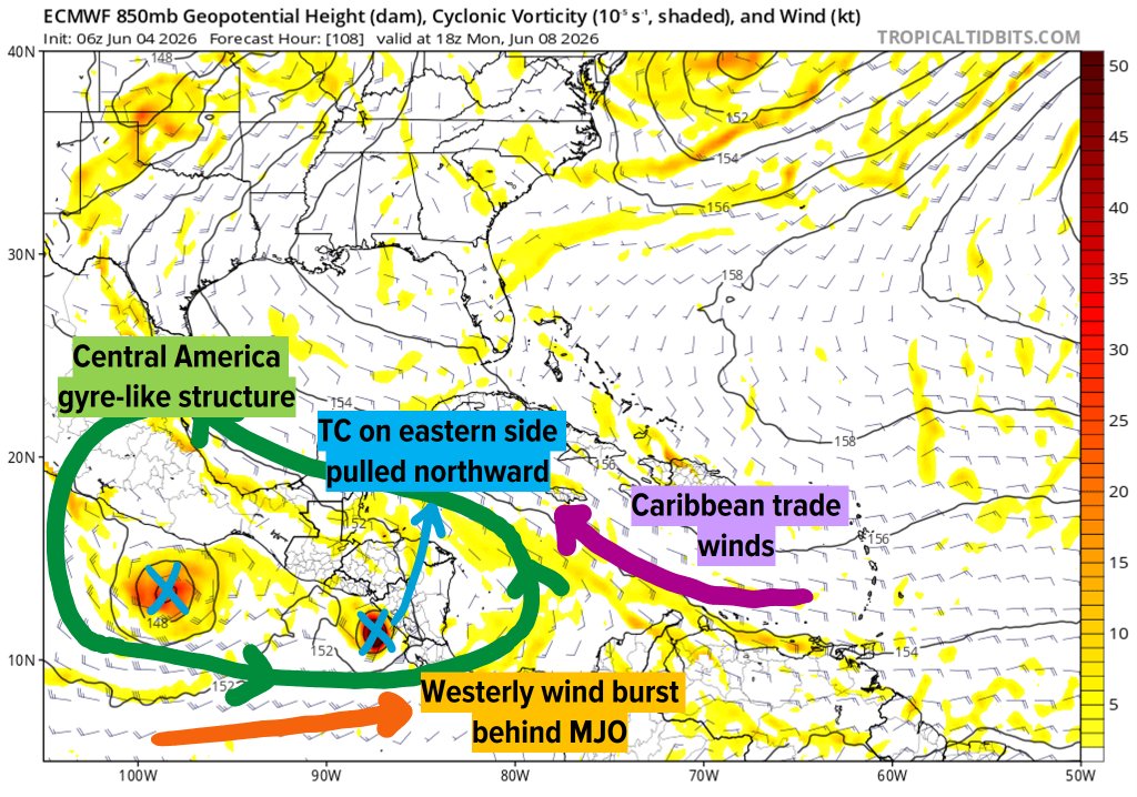
The MJO is passing over the Americas, which will generate low-level vorticity over Central America. This will initially favor TC genesis on the EPAC side, but the eastern TC may eventually cross into the Atlantic. This is a common pathway for June TC genesis, so worth watching.
10
94
5,162
🇺🇸DC⚡️Storms retweeted

Jun 4
🌵Drought Monitor Report Thu June 4
⚠️Still Moderate to Severe Drought for much of our region!!!
Today marks 8 days since we last had rain.
👉BWI Numbers: Rain Deficit since January 1 = -4.79"
Since Jan 1 2024 at -21.70"
🤔🌧️Do you remember all of that rain we got two weeks ago?
Well... The WELLS are not seeing them yet. While some local reservoirs raised up 1 Ft water levels, they are still below average.
AND
☀️Given the high sun angle and long days, a general expectation is that each day we have a net loss of 0.15” to 0.18” water and need 0.20” to 0.25” to replace it and cover any waste.
💦📏What is needed? A single event needs to be about 0.50” to cover runoff and seep into the soil.
#drought

1
5
24
1,985
🇺🇸DC⚡️Storms retweeted

Jun 3
An uptick in EPS members showing some sort of tropical system in the Gulf in 7-14 days. Op ECMWF and GFS have also been showing this. Something to watch.
8
17
125
25,923
🇺🇸DC⚡️Storms retweeted
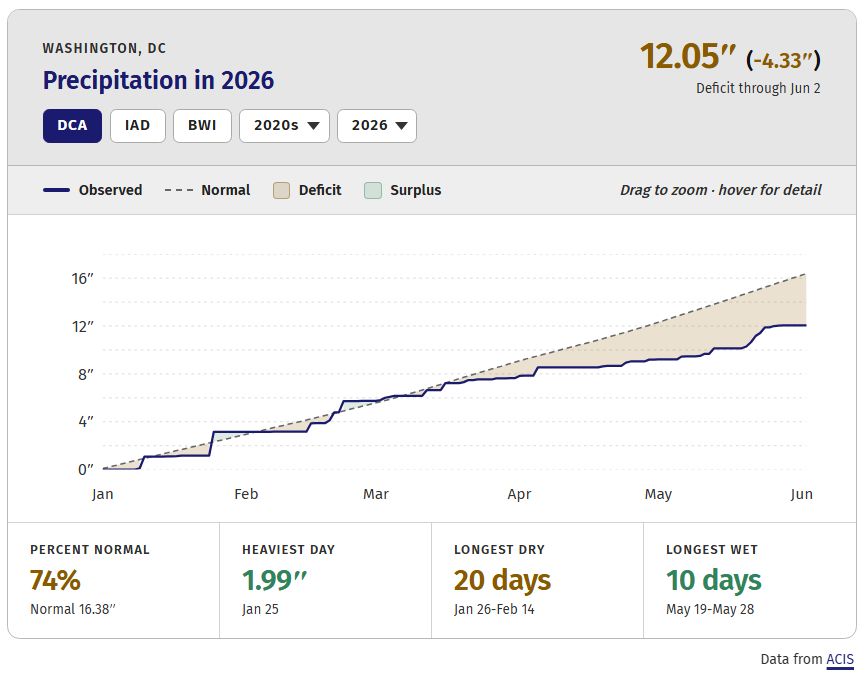
A drought watch is now in effect, following persistent and unusually dry conditions that are expected to last, the Metropolitan Washington Council of Governments (COG) announced Wednesday.
The DC area, and Potomac River watershed more broadly, are dealing with long-term drought conditions. Some easing occurred in mid- to late May, when measurable and beneficial rain fell on 10 straight days.
But DC's year-to-date deficit is 4.33 inches, and the 12-month total of 29.55 inches is 12.27 inches below average. Ten of the last of 12 months have been below average, and the story is the same across the area.
“Our region hasn’t seen extremely dry conditions like this in about two decades when local leaders and COG first established a drought response plan to support coordination and communication regionwide,” said Clark Mercer, COG executive director.
Wednesday's announcement also noted recent rains follow historically low streamflow levels. Amid an episode of high temperatures that overlapped March and April, the Potomac River reached its lowest level observed during the modern record.
A drought watch from COG highlights the risk of dry conditions and encourages smart water use. Ways to limit use include reducing showers, fixing any plumbing leaks, and sweeping sidewalks instead of using a hose.
DC is currently in a Level 2 of 4 drought, termed "severe," according to the U.S. Drought Monitor. The drought reached severe levels in mid-April, but either some level of drought or unusual dryness have affected the region since at least 2024.
The last drought watch from COG was in effect between July 2024 to June 2025. A drought warning has never been issued by COG since the system went into place in 2000.
While drought is a frequent aspect of the DC area climate, recent dryness ranks among some of the most pronounced episodes in modern history. Response to past significant droughts — reservoirs, monitoring and more — means today's similar conditions do not tend to come with major water availability concerns.
Chances for useful rain in our near future are not too promising.

1
20
62
12,710