
Meteorologist/Radar Analyst @tnvalleyweather – Specializing in radar analysis & severe weather forecasting
Joined August 2021
- Tweets 4,350
- Following 460
- Followers 4,122
- Likes 5,043
1,541 Photos and videos


Pinned Tweet

11 Feb 2023
ICYMI: My Stations dual-pol, rapid-scanning X-band Radar is now PUBLIC for all to view in GR2Analyst.
Add the below info to your customradars.gis -
FWLX, FWLX, 35.254963, -87.325317, 220, 1, TN, WLLX X-Band
Restart GR2, and boom! Live data achieved! #tnwx #alwx
19
28
240
79,041
Jun 12
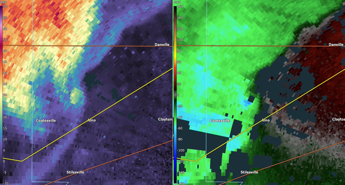
Subtle debris ball and couplet with a jutting quickspin tornado approaching Amo, Indiana - these will sneak up on you in a hurry
1
10
527
Jun 11
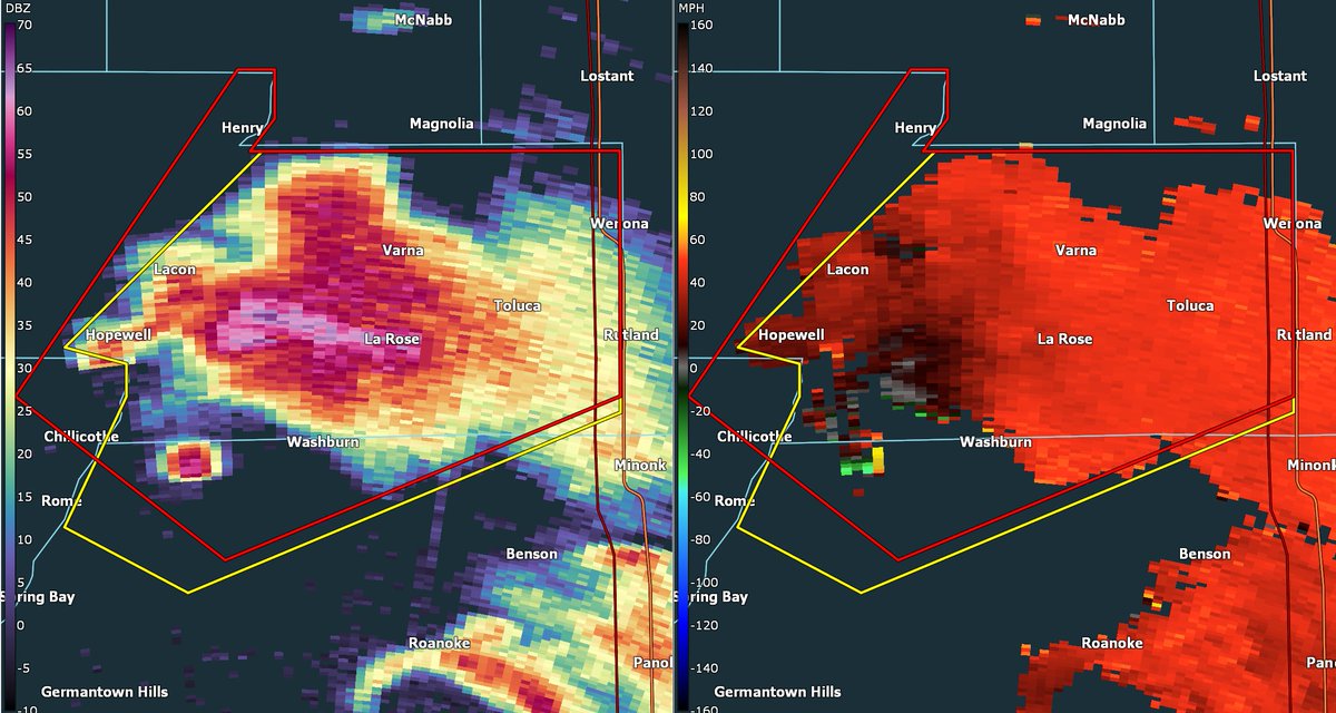
Every bit of an intense tornado - in surely beautiful LP form - near Washburn, Illinois. Not what I expected out of today!
9
58
1,616
Jun 7
KXWA, an EEC C-band up in Williston has a view of that supercell near Bainville, MT. Not what I'd call quality data... but it's something!
2
2
26
2,023
Jun 5
A sentiment worth retweeting on its own. Wind is calculated in profile as a holistic vector quantity for a reason
Jun 5

Wind is a vector, and thus both the direction *and* magnitude matter. Yet in this context chasers tend to hyperfocus on the directional component.
6
735
Jun 4
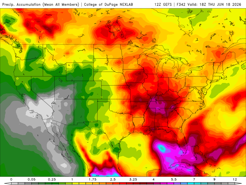
No rest for the wicked down here in the Tennessee Valley. New GFS Ensembles are pegging another 5 inches of rain through the next 14 days. A moderate drought persists so this will help eliminate that, but after the last 10 days of being inundated, I'd like more than 4 days dry !
1
308
Jun 3
When you see that warbled refraction rising off of warm roads in the summer… just know this is the end result !
Jun 3

This is something I have never seen before on satellite.
Clouds perfectly outlining roads.
Just incredibly neat imagery of Houston, Texas this morning.
Massive shoutout to @Emokwx who discovered it.
4
2
28
2,191
May 20
Already 13 years since the infamous Moore, OK tornado, which for some time was the last EF-5 tornado before the infamous “drought”. PX-1000, a mobile radar run by OU ARRC, was perfectly positioned and scanned the tornado thru its entire life
21
199
2,084
255,561
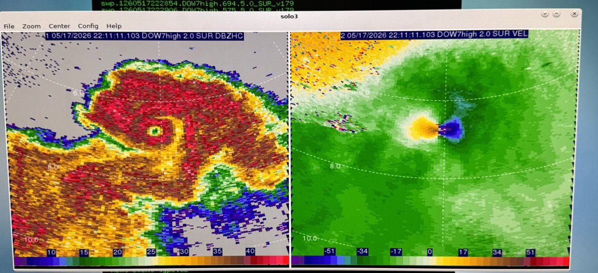
Chase Wilson retweeted

DOW A’s view of the tornado near Saint Libory, NE at 2 different times
Image 1: 2211 UTC with eye
Image 2: 2213 UTC with debris ball
#newx

5
74
227
36,686
May 17
Brookhaven, MS tornado from a week or so ago sure did tear up some forest. Near total treefall through it's path is clear from new satellite imagery over the Homochitto National Forest from Sentinel 2
1
9
70
2,128
May 15
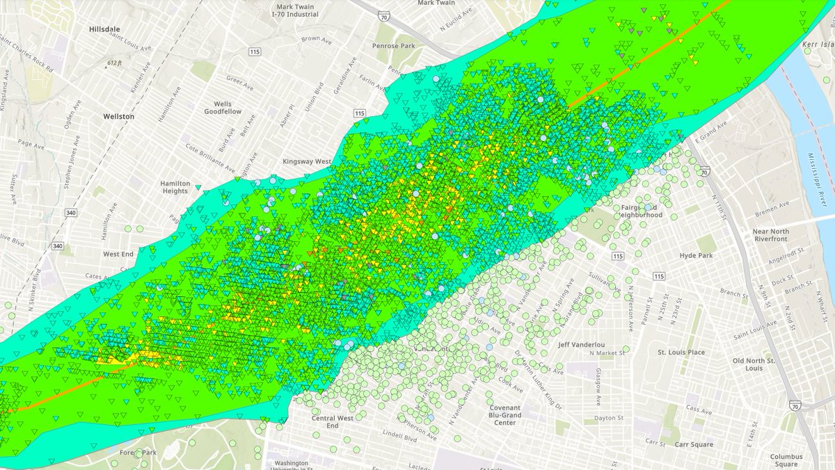
Did somebody order a very, very, very, very, *very* detailed tornado survey? NWS St. Louis has you covered with their revisions on the 5/16/25 tornado path...
4
21
282
10,122
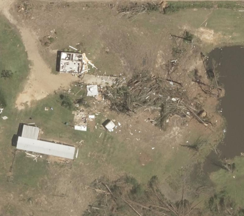
May 14
Tornado damage is so elusive... aerials from the Brookhaven tornado some days ago - a small home is moved and heavily damaged, and vegetation is scarred on the surface. A mobile home, notorious for vulnerability, just yards away, is untouched. Trees behind it? Toppled and snapped
2
3
48
1,940
May 10
Proper funding for NOAA is a matter of national security

The cutting of weather balloon launches is a serious threat to forecasting, and therefore a serious threat to the lives of Americans.
1
10
92
4,466
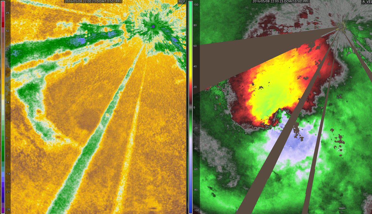
May 9
OTD 10 YEARS AGO: DOW-7 was very nearby the Sulphur, OK tornado and managed to sample 216mph before dashing away. Incredible multi-vortex structure very clear on this one (at ~10m resolution!)
1
17
178
5,852
May 5
I have seen an epidemic of untrained/unbothered mets in non-severe - though shockingly many in severe - markets doing this. Crummy composites, never using single-site radar, even never using velocity… Not saying everyone needs their own radar, but use what you do have!

I’ve seen media using composite radar with smoothing on during tornado warning coverage. And some still had large lightning icons overlaid, and a few more had the fill color of the polygon over it. Horrible.
4
22
2,963
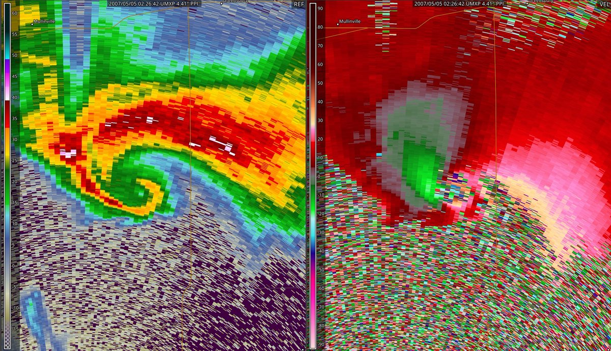
May 4
2 days, 2 anniversaries of E/F5’s captured on mobile radar... OTD in 2007: UMass X-Pol is in S KS, sampling a rapidly cycling supercell that produces several tornadoes, one of which would go on to destroy the town of Greensburg #kswx
19
170
6,345
May 4
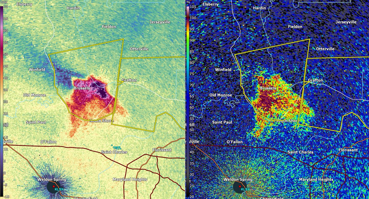
Quite the hailer near St. Louis... but the really interesting thing about it is just how many bugs (and, more notably, BIRDS) are caught up in it. Notice behind it a tail of minimal Z as it's knocked a bunch of poor fliers out of the air
3
7
90
3,521
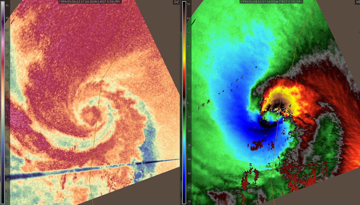
May 3
OTD 27 YEARS AGO: DOW famously samples an F5 tornado in Bridge Creek/Moore, OK, but also near Mulhall. Incredible multiple-vortex structure was present on this very wide and very violent tornado
3
77
552
13,579
May 2
I've seen it mentioned, and while it's prudent not to proselytize doom based on speculation, let us remember that a study that initialized a GEFS synthetic event set for outbreaks estimated that so called "1-in-1000 year" outbreaks may feature 400 tornadoes in a day !
May 1

Reminder we have almost no observed historical timeframes for large tornado outbreaks. We have less than a hundred years of good data. This is almost nothing in terms of a historical record, and even less geologically. For all we know…
2
2
33
3,985
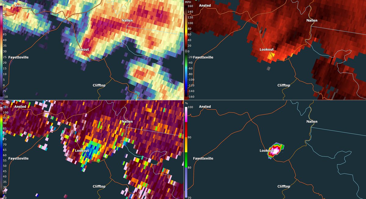
Apr 29
Unwarned tornado just hit Lookout, WV. And by unwarned, I mean it had a just severe thunderstorm warning... which they allowed to expire...?
8
13
186
18,587
Apr 29
I'm not a pot-stirrer, but in my time in the industry I have seen a higher incidence of bad desk calls, incorrect survey results... NWS not really having an accountability structure - or, if it does, a very opaque one - is rearing its head. What is the deal lately?
1
19
2,260