
Chief Meteorologist for WPDE ABC-15. Amateur photographer. N.C. State grad. 7x EMMY Nominated. 0 wins 😀
Joined March 2009
- Tweets 113,731
- Following 1,840
- Followers 63,417
- Likes 104,021
53,498 Photos and videos


Pinned Tweet

Jun 11
EL NIÑO & THE 2026 HURRICANE SEASON
I've been talking about the developing El Niño for months, and today NOAA officially declared that it's here.
Virtually all forecast guidance suggests El Niño will continue strengthening through the coming months and could become a strong, perhaps even very strong (super), event by the peak of hurricane season (August - October).
El Niño develops when ocean waters across the central and eastern tropical Pacific become significantly warmer than normal. That warming alters weather patterns around the globe, including the Atlantic hurricane basin. One of the biggest impacts is an increase in upper-level winds over the tropical Atlantic. Those stronger winds create more wind shear, which can disrupt developing tropical systems and make it harder for hurricanes to organize and intensify.
That's generally good news for hurricane season. In fact, during El Niño years, there have been no major hurricane landfalls (Category 3 or stronger) along the East Coast north of Florida. However, El Niño does not eliminate hurricane risk.
A good example is Hurricane Gaston in 2004. Despite a weak El Niño being in place, Gaston made landfall just south of Myrtle Beach and brought significant impacts to our area.
So while El Niño may stack the deck toward a quieter Atlantic hurricane season overall, it's not a guarantee we won't get hit. We should continue to prepare and stay weather-aware throughout the season.
As I always say, it only takes one storm hitting you to make it a bad hurricane season.


1
7
51
2,934


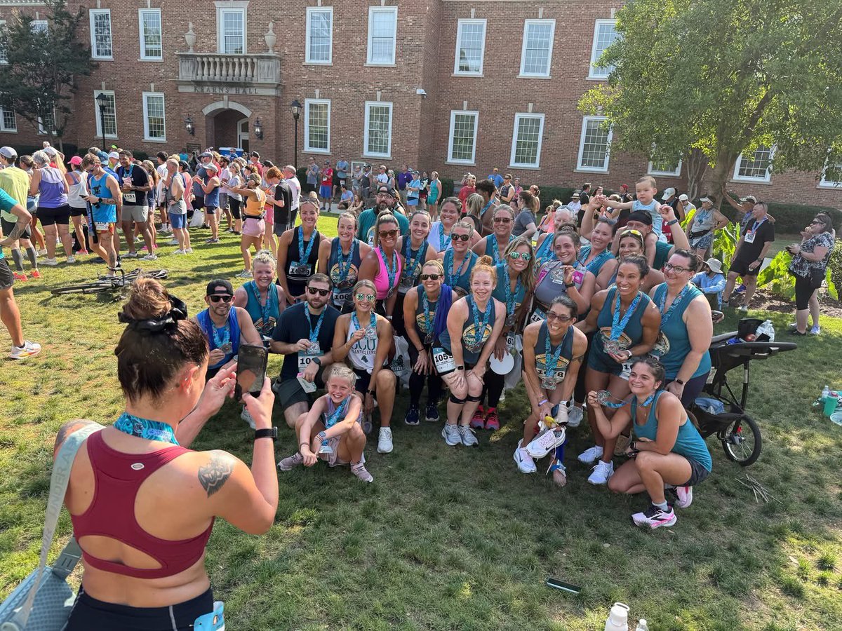
Amazing day for "Ed's Hurricane Hustle" through the beautiful campus of Coastal Carolina University! 809 strong braved the heat and humidity to run the 1-miler, 5K or 10K. The costumes, people, vendors and sponsors were awesome and made for such a great morning. So nice to see all of you! Very proud of the entire staff at WPDE ABC15 for all their hard work making the live broadcast of the race successful.
Of course, none of this is possible without our great community partners. Thank you all for your support of the race & expo and our community!
HTCincsc - Your Local Internet Provider
Vines Heating & Air, Plumbing, Restoration
Black Dog Running Company - Myrtle Beach
Monarch Roofing
Tide Law Firm, LLC
theyardgym__myrtlebeach
Carolina Trust Federal Credit Union
Seaside Furniture Gallery & Accents


12
1,240
What a fantastic morning at “Ed’s Hurricane Hustle!”
A huge thank you to my good friend at True Light Photography for capturing the excitement at the starting line. What a sight to see!
Even better, we set a new event record with 807 runners and walkers participating this year. That’s incredible!
Special thanks to @CCUChanticleers for once again hosting this amazing event and helping make it such a success. Can’t wait to have you run next year @CCUPres1954!
I’ll be sharing many more photos this afternoon, along with a post recognizing our incredible sponsors who helped make this event possible.
1
29
1,952
Jun 12
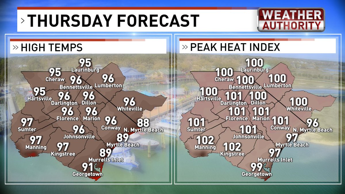
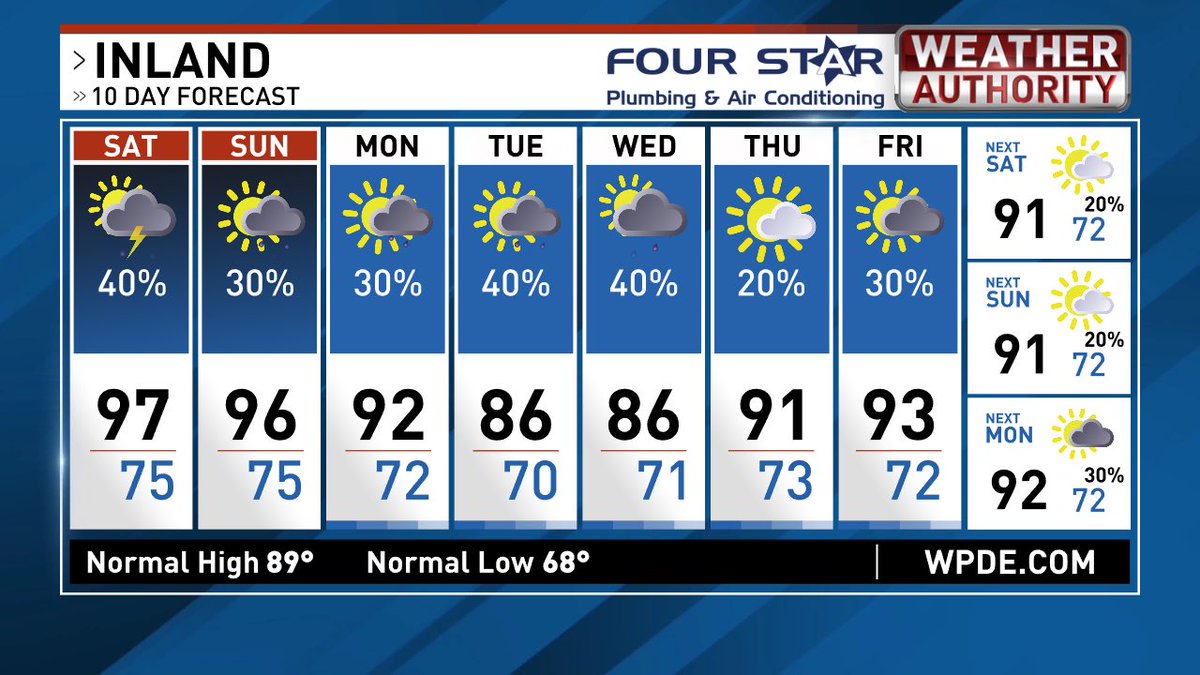
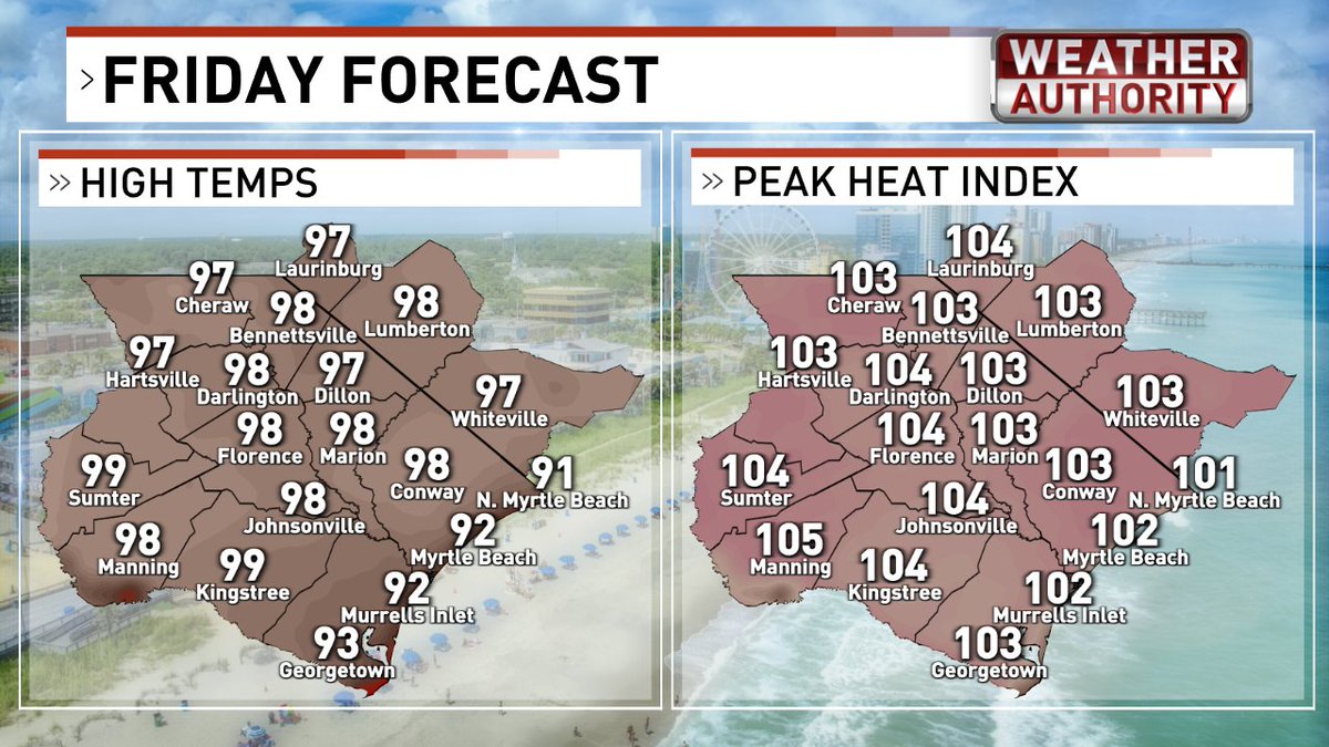
High heat and humidity again this weekend. Actual high temperatures will climb into the mid to upper 90s away from the coast and low 90s at the beaches. Heat index values in the afternoon will peak around 105°. Both days will have better chances of storms than what we had today. On Saturday the sea breeze could become quite active with scattered storms after 1 pm. Expect frequent lightning, heavy rain and gusty winds with any of the storms in Horry and Georgetown counties. As we head through the afternoon, the best chances will be farther inland across the Pee Dee and on the Border Belt. Mostly dry on the beaches. We’ll do it all over again on Sunday. Rain chances may actually go up for Tuesday and Wednesday, but that will depend on how much moisture reaches us ahead of the cold front.


1
1
27
1,477
Jun 12
3:30 PM - A strong storm capable of 40-50 mph winds and 1/4 sized hail is moving southeast at 10 mph.
1
3
24
1,948
Jun 12
“Ed’s Hurricane Hustle” is tomorrow (6/13) at 8 AM at coastal Carolina University. These amazing ladies and 800 of your closest friends will run, walk, or crawl the 1 mile, 5K or 10 K race! We’d love to see you there. You can still sign up: runsignup.com/Race/SC/Conway…
12
838
Ed Piotrowski retweeted

Jun 12
Happy Friday! #Calabash @EdPiotrowski @medwick @DylanHudlerWXII @jamiearnoldWMBF @LeeHaywoodWX @dogwoodblooms @marioncaldwx @JustinMcKeeWx @StarboardRail @ThePhotoHour @CMorganWX @Christina4casts @AndrewWMBF @ScottyPowellWX @jgreenhillwx @TimBuckleyWX @matt_wx @clairefrywx


7
34
1,127
Ed Piotrowski retweeted

Jun 12
Good Morning from PawleysIsland #myrtlebeach ❤️🏝️ @AndrewWMBF @jamiearnoldWMBF @jgreenhillwx @liamswx @EdPiotrowski @ScottyPowellWX @wmbfweather @weatherchannel @scwxpix @natwxdesk @CarolinaWxGroup @CNNweather @HammockCoastSC @MyMyrtleBeach @wpdeabc15 @spann @ThePhotoHour


6
27
4,800
Ed Piotrowski retweeted

Jun 12
Good morning and may your day be filled with giving away kindness, goodness and light. #FridayFeeling @EdPiotrowski @AndrewWMBF @JimCantore @liamswx @Axaxia88 @Dan_Kinghorn77 @A_AMilne @8ntmuch @GardenCitySC @InspiringThinkn @Oprah @Tim_Yocum @ClintHurdle13 @debanjana05
😊☮️❤️🙌

8
6
63
1,548
Jun 12
Venus and Jupiter shining brightly in the post-sunset sky. Took this photo in my backyard with my iPhone.
5
14
96
2,062
Jun 11
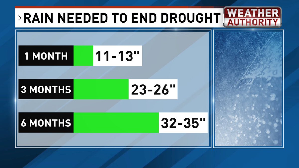
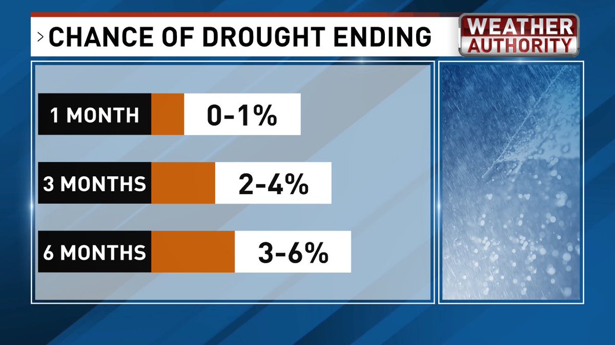
There’s basically been no improvement in the drought across South Carolina, while conditions have actually worsened in parts of North Carolina.
The reality is that we need rainfall well above normal over the next six months to make a meaningful dent in the drought. Unless we get lucky with a tropical system (preferably weak) that really soaks the Carolinas, the odds of completely getting out of the drought during the next six months are slim to none.
We’ll certainly get rain along the way, but it’s going to take much more than our typical rainfall to erase the long-term deficits.

1
5
40
3,095
Jun 11
Hi everyone! Join Chauncey and me for my 4th Annual "Ed's Hurricane Hustle" this Saturday, June 13th at 8am at @CCUChanticleers !You can run, walk or crawl the 1 mile, 5K or 10K races. We don't care how you do it, we just want you to finish to get your medal! We'll also have cool "That's What Ed Said" towels for everyone (free). Best of all, a portion of the proceeds will benefit the Fellowship of Christian Athletes. Sign up before we sell out! runsignup.com/Race/SC/Conway…
28
1,105

Ed Piotrowski retweeted

Jun 11
Good morning from Surfside Beach, South Carolina ✨🏖️ #sunrise @EdPiotrowski @jamiearnoldWMBF @AndrewWMBF @liamswx @jgreenhillwx
1
11
72
2,138
Ed Piotrowski retweeted
Jun 11
Good morning! #SunsetBeach @EdPiotrowski @medwick @DylanHudlerWXII @jamiearnoldWMBF @LeeHaywoodWX @dogwoodblooms @marioncaldwx @JustinMcKeeWx @StarboardRail @ThePhotoHour @Christina4casts @CMorganWX @AndrewWMBF @ScottyPowellWX @jgreenhillwx @TimBuckleyWX @matt_wx @clairefrywx


1
7
35
1,100
Jun 11
Venus and Jupiter shining brightly in the western sky this evening. Photo by me from my backyard in Myrtle Beach.
3
10
90
2,185
Jun 10
Just three days until "Ed's Hurricane Hustle" and we still have a few spots available! Join us at @CCUChanticleers at 8 am to run, walk, or crawl the 1 miler, 5k, or 10k! Everyone gets a cool medal and a beach towel. A portion of the proceeds will benefit the Fellowship of Christian Athletes! Regster here: runsignup.com/Race/SC/Conway…
14
925
Jun 10
HERE COMES THE HEAT!
While we won't break any records, the hottest air so far this season arrives tomorrow, peaks on Friday, and sticks around through the weekend. Despite all the heat, not much rain is expected through Sunday. With a cold front approaching on Monday, we could see a better chance of afternoon storms.


1
4
27
1,370
Jun 10
Congrats Alex!!

Today I am officially graduating Southwestern Randolph High School
@CMorganWX @TimBuckleyWX @DylanHudlerWXII @DylanAllenWx @ScottyPowellWX @jamiearnoldWMBF @AndrewWMBF @JamesWFMY @amberlakeTV @weatherinNC @ChrisMartzWX @gradyryan1 @NCDOT @VaDOT @Clt_TrafficGuy @AWilliamsWX @LeeHaywoodWX @liamswx @WeathermanVern @WeatherBrittany @VincentWX_1 @EdPiotrowski @AlexCorderoWX @AlexSchneiderWx @MMoore_hoops

14
1,817