
Joined October 2017
- Tweets 576
- Following 125
- Followers 1,758
- Likes 760
12 Photos and videos


Pinned Tweet

Feb 15
To celebrate GeoPackage day that just passed. I want to share our new Bluesky profile. Follow us over at
geopackage1.bsky.social
1
2
4
323

Artemis II is still in flight, and you can follow it live in 3D!
Orbit Codex’s Artemis II flight tracker is built on CesiumJS.
Track the mission before splashdown and read more about how the tracker was built: hubs.li/Q04bjZBs0
#ArtemisII #CesiumJS #NASA #Aerospace
2
4
35
2,164
GeoPackage retweeted

Apr 9
New release!! 🪸🌏 Try our new "Google Maps for Coral Reefs" and fly around 100M Gaussian Splats right in your browser! \o/
We've hit a new milestone today! Every day my job is to look at hundreds of the most stunning, vibrant coral reefs on the planet.. I’m so bummed that I can’t simply share this beauty with you! Until now, our 100M splat models were too massive to share without instantly crashing your browser or phone. Today, that changes.
🔵 Why? All coral reefs in the world combined are only roughly the size of New Zealand. Yet they support over 1/4 of all marine life and up to a billion people! Corals are so precious, beautiful, incredibly complex and threatened ecosystems. They are dying fast. A lot of amazing people are fighting to save them. To win we need to deploy more solutions faster. We need to understand deeply how coral reefs function, what methods work, what don't, to coordinate precise action. That's why we are doing it.
🔵 How? Progressive 3D streaming. We now support multiple levels of detail (LODs) and load only what you look at. You can easily fly over 1000 sq meter patches of reef down to the centimeter detail. No beefy GPUs on the backend rendering your data in real-time. We simply fetch static data from cloud buckets (R2 CDN) and the reef streams smoothly in your browser as you move. Even on your phone. No backend to fail, which means we can scale infinitely!
🔵 Ground truth is everything. To do actual science, the twin has to act like a spatial database. You need different views for different tasks. We made it so you can seamlessly switch between flying in 3D, looking at a 2D map, or checking the raw photos without losing your context. You can spot an interesting coral in 3D, click it, and instantly look at the exact ground-truth photos the diver took.
🔵 The viewer is still super scrappy and you will absolutely find bugs. We used duct tape here and there. Still early days. We'll open-source it eventually, but right now we're moving too fast and don't want to break things for others. But even with the rough edges, I don't think there's a higher-resolution large 3D reef anywhere on the internet you can just open with a link.
🔵 This wouldn’t be possible without the amazing efforts of many brilliant people:
- Matthew Osborne (creator of The Living Atlas) who joined forces with us to build this high-performance digital twin
- @willeastcott and the @playcanvas team who built the underlying 3D web engine to stream these massive LODs
- The real heroes collecting this data in the water and driving action through cutting-edge research: @alderdice_r, @reefgenomics, @emmafcamp, @PaigeStrudwick , and @ChristineDRoper, alongside the University of Konstanz and Wavelength Reef Cruises.
🔵Play with the 3D reef model: app.wildflow.ai/konstanz_ray…
🔵 Billions of people depend on our ability to protect these ecosystems. There are NO laws of physics saying we can't fix this mess. We can be the first generation that leaves nature better than we found it! We can only do this together 🤗
6
36
288
16,729
GeoPackage retweeted

Apr 8
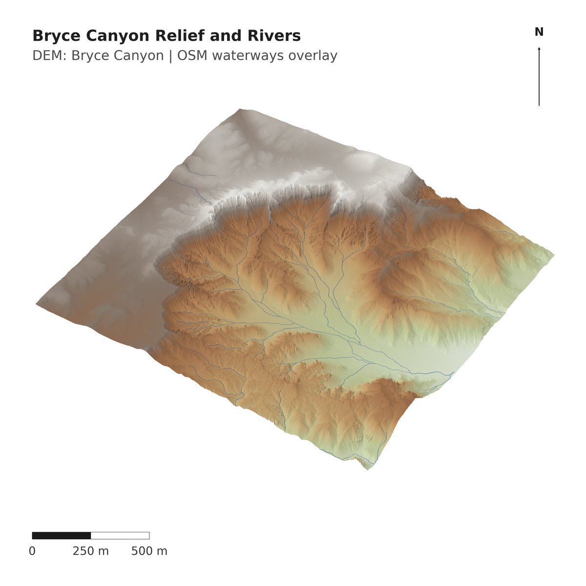
Bryce Canyon🇺🇸 rendered in Python (4k resolution) in <1 min.
Used forge3d 👉github.com/milos-agathon/for…

1
13
95
25,240
GeoPackage retweeted

Apr 8
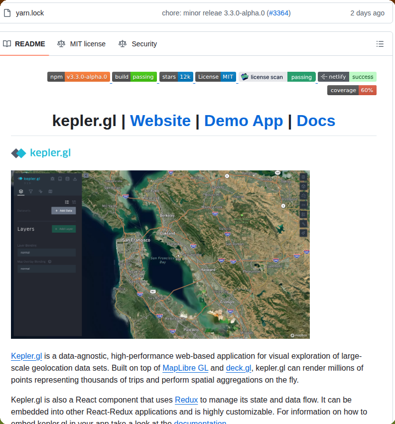
Visualizes large-scale geolocation data sets
github.com/keplergl/kepler.g…
2
14
130
6,752
GeoPackage retweeted

Apr 8
Iwfgara(iwfgara.com) is continuously evolving. We're working on extracting and visualizing only the rotating winds like cyclone from wind field data, along with a feature that shows their movement over time. Real cyclones MAILA, VAIANU occurred northeast of Australia.
1
13
706
GeoPackage retweeted

Apr 9
If you enjoyed the TerraBit app (1), then you'll enjoy knowing that I'm open sourcing it! (2) Feel free to contribute, optimize or build on top of it!
If you like the aesthetic of the app, I've also created a `geospatial-frontend` SKILL.md by scraping my convos with Claude! You can install it from the geospatial-skills repo! (3)
(1) isaac.earth/terrabit/
(2) github.com/isaaccorley/terra…
(3) isaac.earth/geospatial-skill…
7
36
451
21,778
GeoPackage retweeted

Apr 9
Geofabrik download Server Update: adding Geopackage format blog.geofabrik.de/index.php/…
1
14
1,055

GeoPackage retweeted

Georeferencing in QGIS isn’t just about control points, it’s about the right transformation.
Linear, Helmert work best for maps with minimal distortion
Polynomial (1st–3rd order), Thin Plate Spline handle old /warped maps.
A detailed video explanation is attached in the comments
1
9
72
2,588
GeoPackage retweeted
All 13.5 million jobs in Texas, visualized by sector in @Mapbox with block-level precision.
The just-released 2023 LODES data is one of the most underrated public datasets.
48
269
3,045
201,608
GeoPackage retweeted

Jan 10
Tired of the default colors?
QuickMap now lets you customize them.
Oh, and 1024x1024 heightmaps are enabled too.
quickmap.dev/
#webdev #devtools #threejs
2
11
146
6,715
GeoPackage retweeted

Jan 6
QGIS plugin that unlocks access to 80 petabytes of satellite imagery and geospatial datasets with zero coding required.
5
34
301
11,144
GeoPackage retweeted

Jan 6
One line of code.
That’s all it takes to get access to Google Open Buildings, the largest building dataset, for any country.
100% free and available globally.
79
887
14,713
1,912,787
GeoPackage retweeted

26 Dec 2025
Here, I’m spending my holidays extracting colors with #QGIS. What’s most interesting, and immediately applicable, about studying the use of #color in old maps is their limited palette. This #map looks visually rich, yet it was created using just six colors. Less is more!
5
59
623
68,688
GeoPackage retweeted
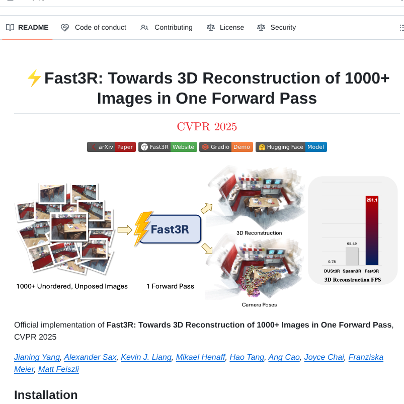
26 Dec 2025
Reconstructs 3D scenes from 1000 images in one forward pass
github.com/facebookresearch/…
4
91
766
42,327
GeoPackage retweeted

23 Dec 2025
If you work in geospatial, PMTiles is one of the technologies you need to know going into 2026.
This past year, I wrote an R package to help you get started.
Learn how here: walker-data.com/posts/pmtile…
2
13
135
7,953
GeoPackage retweeted

23 Dec 2025
Our new workshop "From Cloud to Desktop: Working with Earth Engine Data in QGIS" is now available on YouTube! This workshop provides a gentle introduction to Earth Engine for QGIS users and unlocks Petabytes of cloud datasets in QGIS without any coding! youtube.com/watch?v=FjyXQqoS…
1
19
97
14,492