- Tweets 17,307
- Following 1,063
- Followers 11,523
- Likes 18,935


ALT graphic showing the current high wind warning headlines, covering the entire nws cleveland forecast area. also showing timing of strongest wind gusts across the area, mainly during the day Friday.
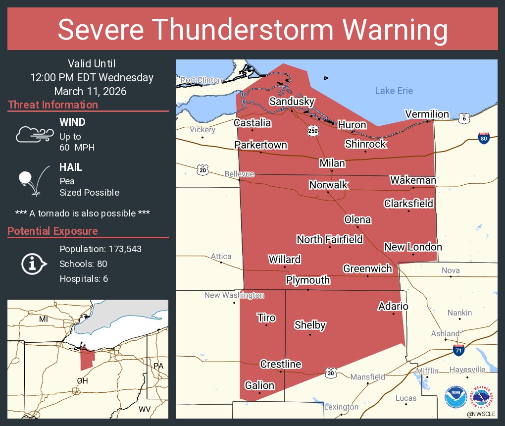
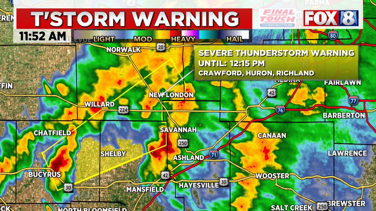
ALT This graphic displays a severe thunderstorm warning plotted on a map. The warning is in effect until 12:00 PM EDT. The warning includes Sandusky OH, Norwalk OH and Vermilion OH. This warning is for Huron County in north central Ohio, Northern Richland County in north central Ohio, Ottawa County in northwestern Ohio, Erie County in north central Ohio and Eastern Crawford County in north central Ohio. The threats associated with this warning are wind gusts up to 60 MPH and pea sized hail. There are 173,543 people in the warning along with 80 schools and 6 hospitals.
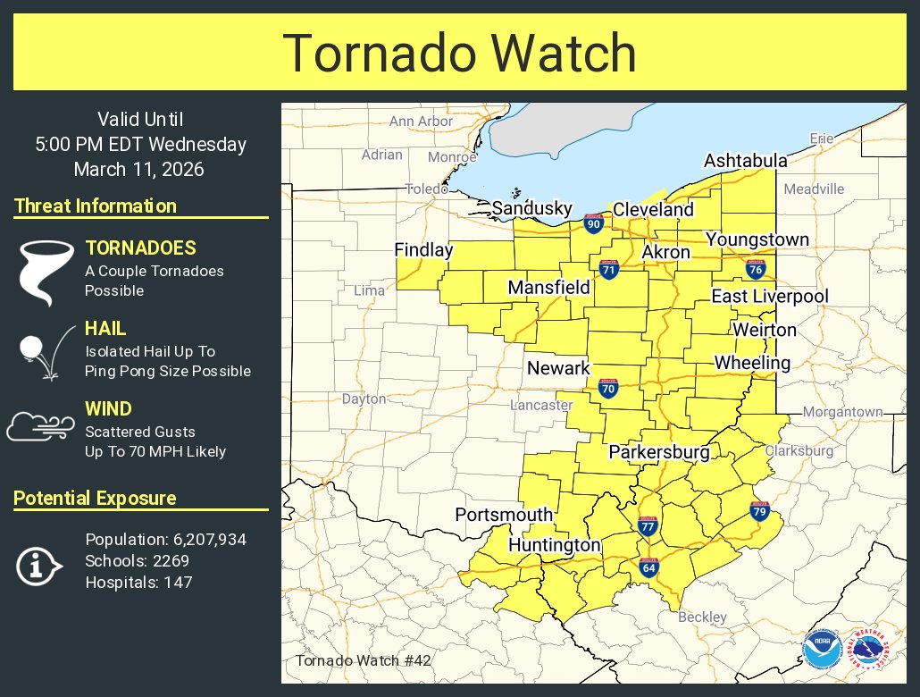
ALT This graphic displays Tornado Watch watch number 42 plotted on a map. The watch is in effect until 5:00 PM EDT. The watch includes parts of Kentucky, Ohio and West Virginia. The threats associated with this watch are a couple tornadoes possible, isolated hail up to ping pong size possible and scattered gusts up to 70 mph likely. There are 6,207,934 people in the watch along with 2269 schools and 147 hospitals.

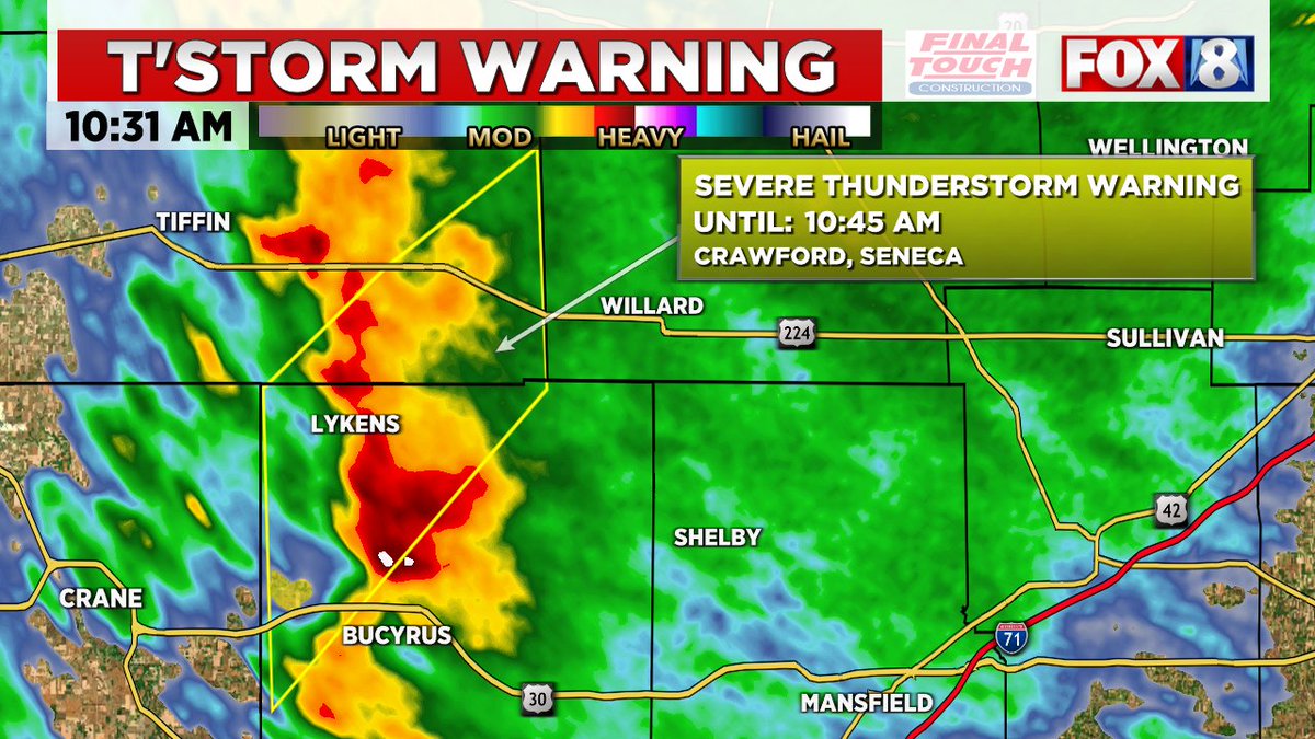
ALT This graphic displays a severe thunderstorm warning plotted on a map. The warning is in effect until 11:30 AM EDT. The warning includes Tiffin OH, Fremont OH and Fostoria OH. This warning is for Seneca County in northwestern Ohio, Sandusky County in northwestern Ohio, Southeastern Wood County in northwestern Ohio and Northeastern Hancock County in northwestern Ohio. The threats associated with this warning are wind gusts up to 60 MPH and pea sized hail. There are 103,043 people in the warning along with 51 schools and 4 hospitals.


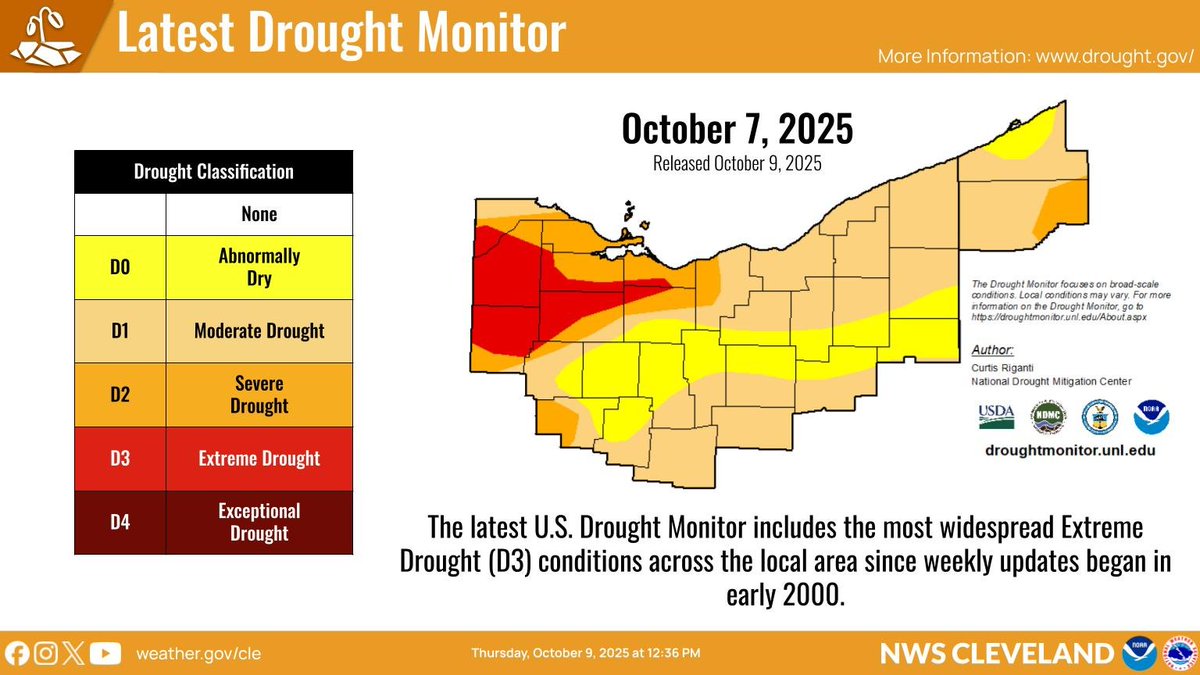
ALT Graphic with the latest U.S. Drought Monitor. The table on the left indicates each drought category and the image on the right is the latest Drought Monitor for the NWS Cleveland forecast area, valid October 7, 2025 and released October 9, 2025. Text at the bottom of the graphic: The latest U.S. Drought Monitor includes the most widespread Extreme Drought (D3) conditions across the local area since weekly updates began in early 2000.
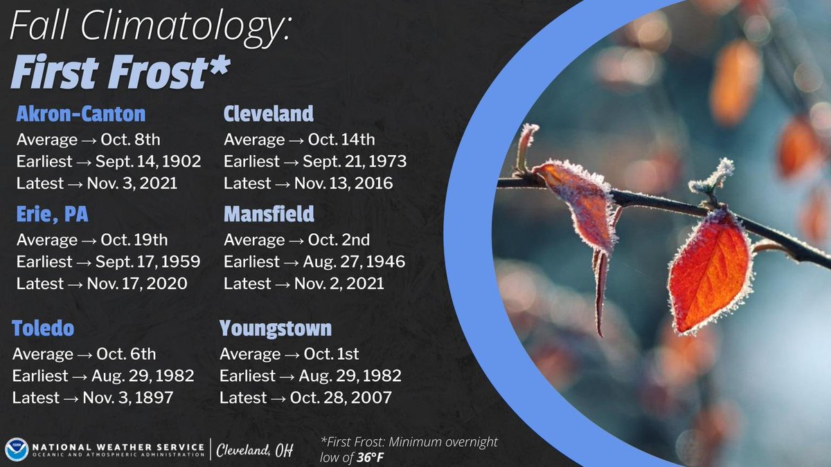
ALT A graphic titled “Fall Climatology: First Frost.” It lists average, earliest, and latest first frost dates for several climate sites in northern Ohio and northwest Pennsylvania. Akron-Canton: average Oct 8, earliest Sept 14 1902, latest Nov 3 2021. Cleveland: average Oct 14, earliest Sept 21 1973, latest Nov 13 2016. Erie PA: average Oct 19, earliest Sept 17 1959, latest Nov 17 2020. Mansfield: average Oct 2, earliest Aug 27 1946, latest Nov 2 2021. Toledo: average Oct 6, earliest Aug 29 1982, latest Nov 3 1897. Youngstown: average Oct 1, earliest Aug 29 1982, latest Oct 28 2007. A note defines “first frost” as a minimum overnight low of 36°F. The right side of the graphic shows a close-up photo of red and orange leaves coated with morning frost.
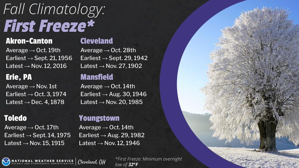
ALT A graphic titled “Fall Climatology: First Freeze.” It lists average, earliest, and latest first freeze dates for several climate sites in northern Ohio and northwest Pennsylvania. Akron-Canton: average Oct 19, earliest Sept 21 1956, latest Nov 12 2016. Cleveland: average Oct 28, earliest Sept 29 1942, latest Nov 27 1902. Erie, PA: average Nov 1, earliest Oct 3 1974, latest Dec 4 1878. Mansfield: average Oct 14, earliest Aug 30 1946, latest Nov 20 1985. Toledo: average Oct 17, earliest Sept 14 1975, latest Nov 15 1915. Youngstown: average Oct 14, earliest Aug 29 1982, latest Nov 12 1946. A note defines “first freeze” as a minimum overnight low of 32°F. The right side of the graphic shows a large tree completely covered in frost against a bright blue sky.


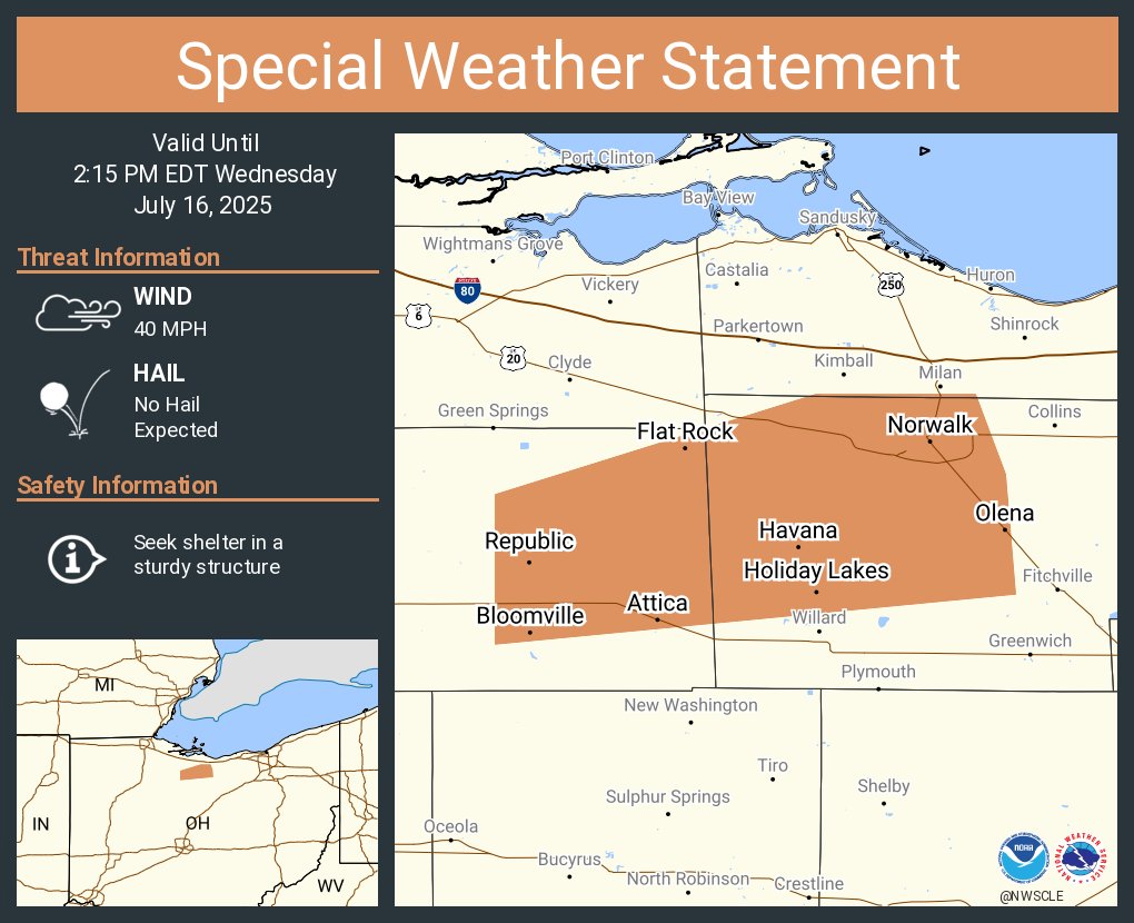
ALT This graphic displays a special weather statement plotted on a map. The statement is in effect until 2:15 PM EDT. The statement includes Norwalk OH, Monroeville OH and Bloomville OH. A STRONG THUNDERSTORM WILL IMPACT NORTHWESTERN HURON AND EASTERN SENECA COUNTIES THROUGH 215 PM EDT. The threats associated with this storm are wind gusts up to 40 MPH and no hail is expected. Seek shelter in a sturdy structure until the storm passes.

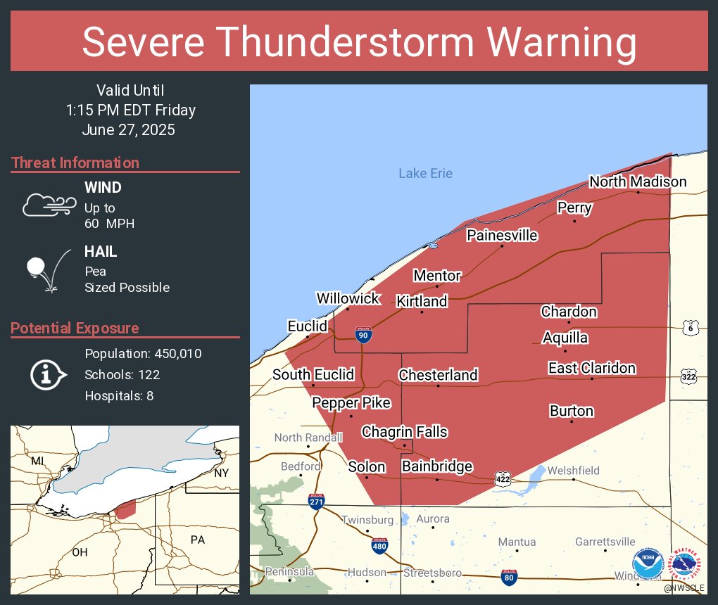
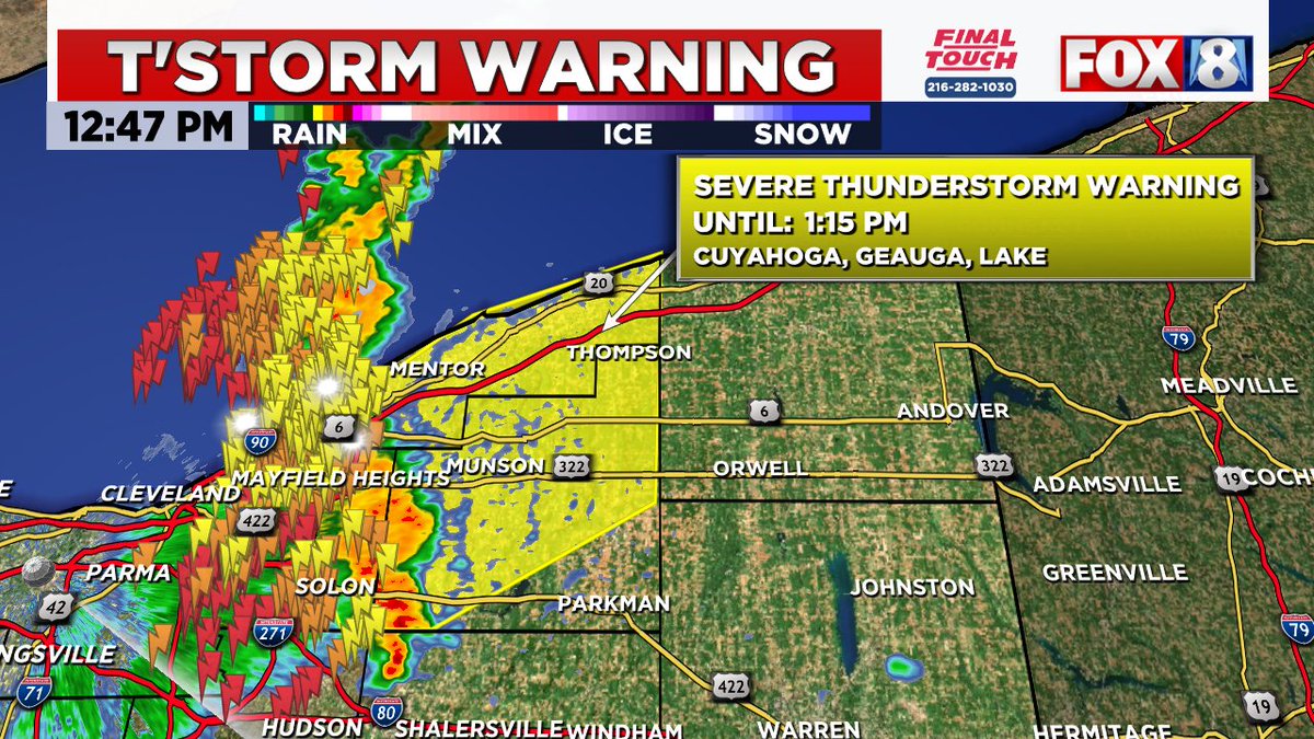
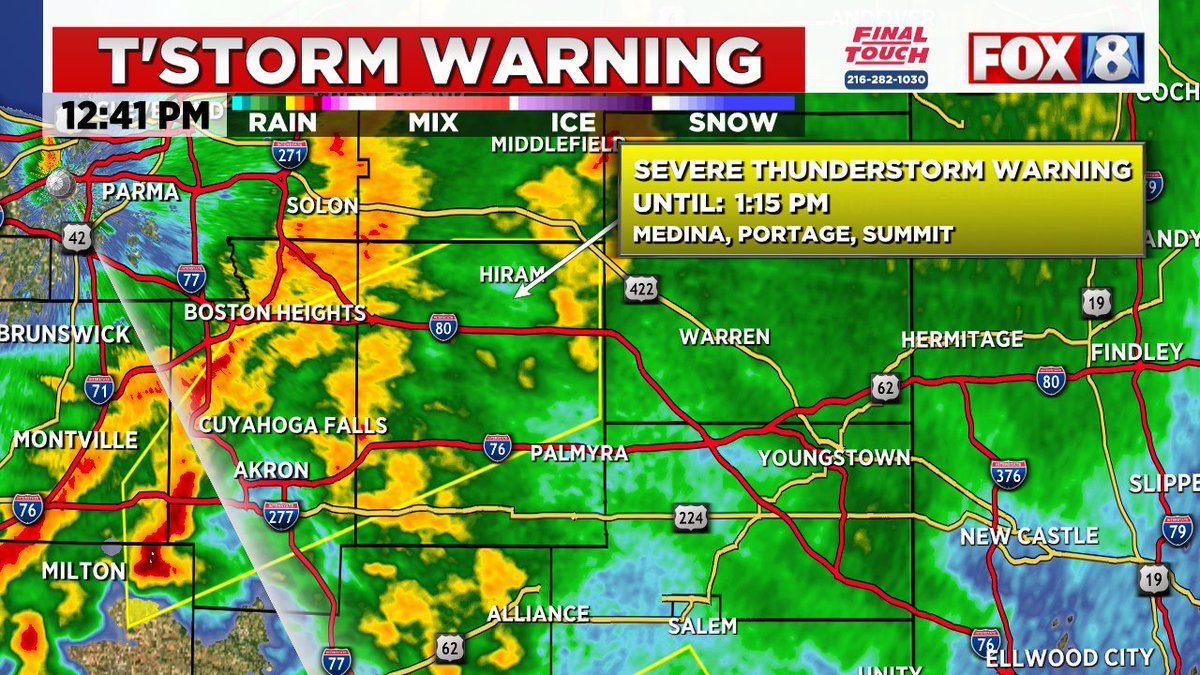
ALT This graphic displays a severe thunderstorm warning plotted on a map. The warning is in effect until 1:15 PM EDT. The warning includes Euclid OH, Mentor OH and Solon OH. This warning is for Geauga County in northeastern Ohio, Northeastern Cuyahoga County in northeastern Ohio and Lake County in northeastern Ohio. The threats associated with this warning are wind gusts up to 60 MPH and pea sized hail. There are 450,010 people in the warning along with 122 schools and 8 hospitals.
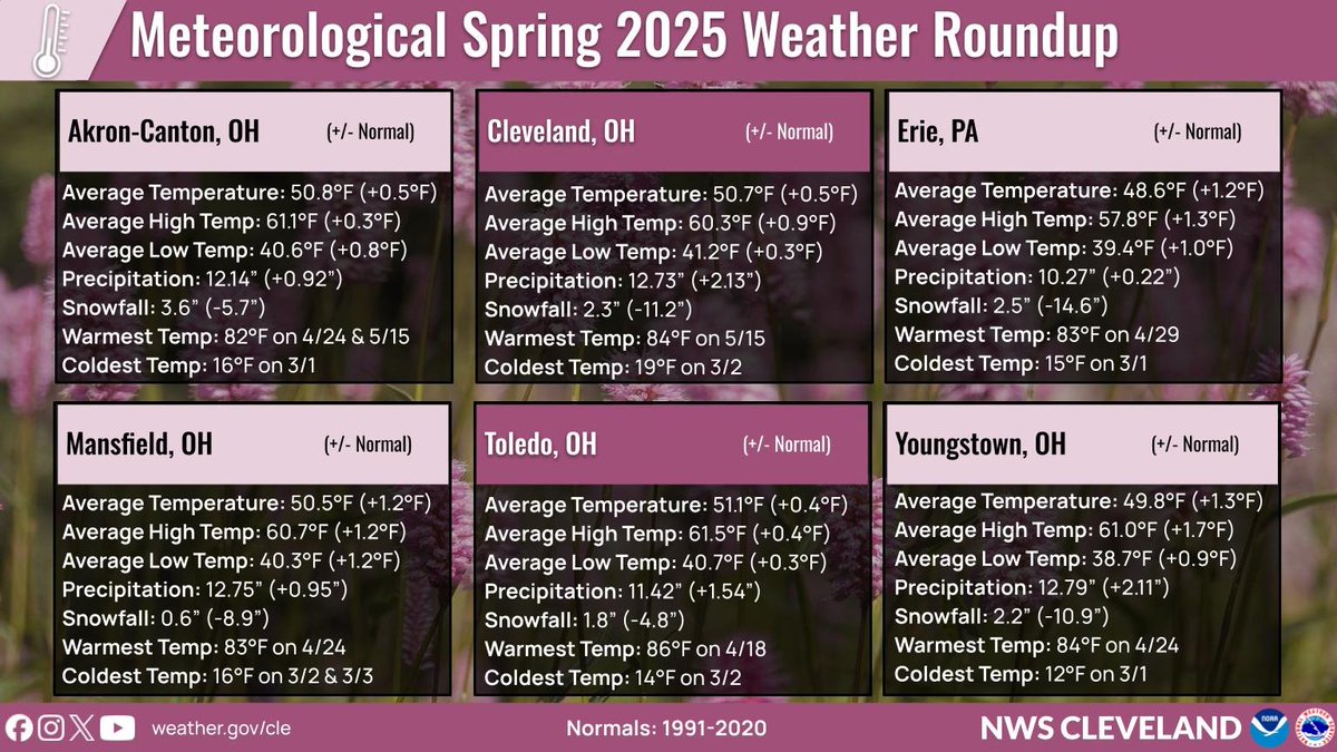
ALT Average temperatures, total precipitation and snowfall for the March through May time period across Northern Ohio and Northwest Pennsylvania.

ALT This graphic displays Severe Thunderstorm watch number 226 plotted on a map. The watch is in effect until 9:00 PM EDT. The watch includes parts of Ohio and West Virginia. The threats associated with this watch are a couple tornadoes possible, scattered hail up to ping pong size possible and scattered gusts up to 70 mph possible. There are 2,931,132 people in the watch along with 1080 schools and 61 hospitals.
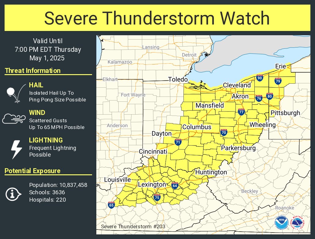
ALT This graphic displays Severe Thunderstorm watch number 203 plotted on a map. The watch is in effect until 7:00 PM EDT. The watch includes parts of Kentucky, Ohio, Pennsylvania and West Virginia. The threats associated with this watch are no tornadoes expected, isolated hail up to ping pong size possible and scattered gusts up to 65 mph possible. There are 10,837,458 people in the watch along with 3636 schools and 220 hospitals.