
We aim to hone biodiversity research by providing open data from remote sensing and GIS methods.
Joined February 2014
- Tweets 40
- Following 169
- Followers 170
- Likes 32
2 Photos and videos

11 Feb 2019
New paper on the #ecotope in @RemoteSens_MDPI . And a new ecotope map of Belgium mid-2019.
mdpi.com/2072-4292/11/3/354/…
3
5
11 Oct 2018
Call for abstract for the "terrestrial biodiversity" session at the ESA Living planet symposium 2019 lps19.esa.int/QuickEventWebs…
1
1
1
5 Jun 2018
We are looking for an enthousiast phD student on "Natural habitat monitoring using Sentinel‐1&2 satellite time series for biodiversity assessment" at @ELI_UCLouvain to contribute to @LifeWatchERIC
19 Jan 2018
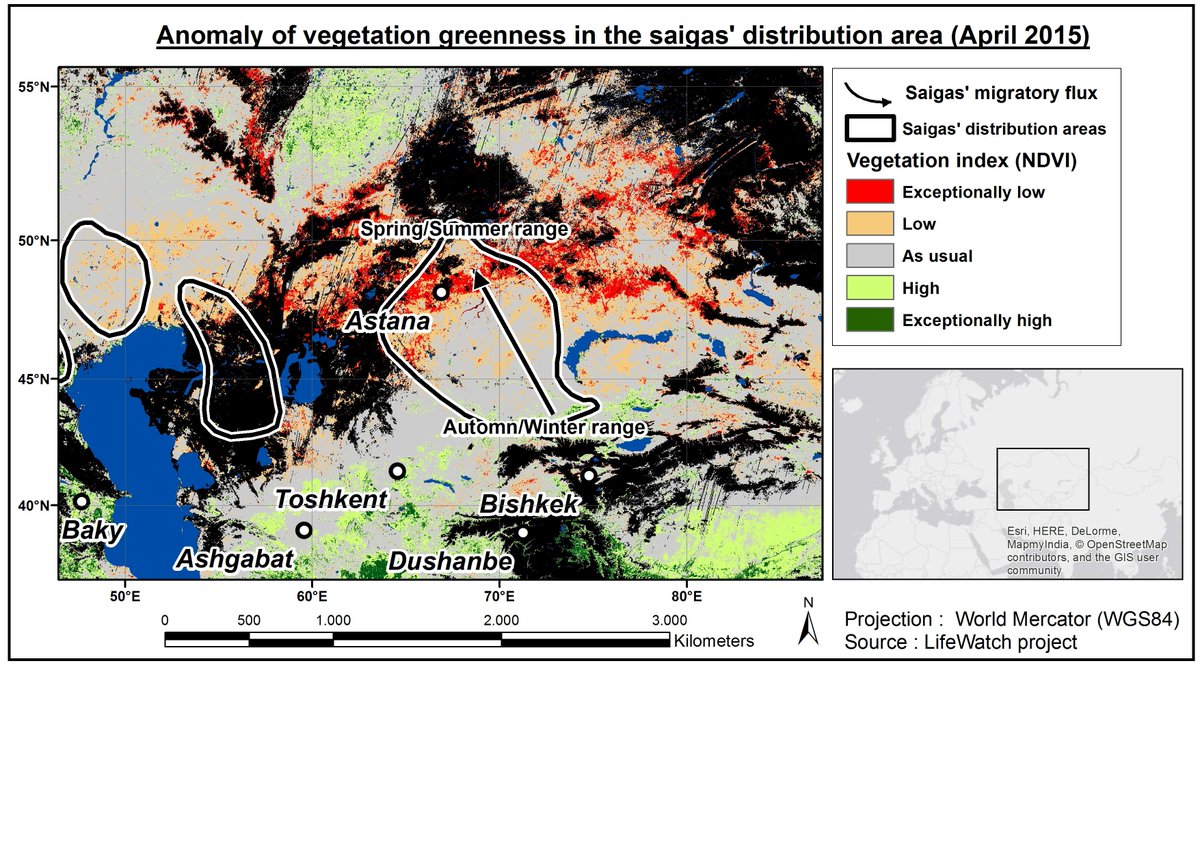
Proud to be part of the multidisciplinary team that discovered why 60% of the worlds saiga population died in 2015. Lean more in @ScienceAdvances advances.sciencemag.org/cont…
1
2
LifeWatch WB retweeted

12 Jan 2018
LifeWatch.be Users & Stakeholders Event, register on registration.vliz.be/lifewat…
Date: January 25th-26th 2018
Venue: Ostend, InnovOcean Site, Wandelaarkaai, Flanders Marine Institute (@LifeWatchVLIZ ), UNESCO auditorium #lifewatch #biodiversity #informatics
3
1
LifeWatch WB retweeted

4 Dec 2017
SAVE THE DATE! The 53rd European Marine Biology Symposium (EMBS53) will be in Ostend, Belgium, 17-21 September 2018. @EMBSsymposium Organized by @jmeesvliz and @LifeWatchVLIZ youtube.com/watch?v=OObKayhn… embs53.org
7
6
LifeWatch WB retweeted
24 Nov 2017
Check out our new homepage! The LifeWatch.be #Dashboard, showcasing the outcome and results of the #Belgian #LifeWatch #Infrastructure! lifewatch.be/ @LifeWatchINBO @LifeWatch_WB

4
2
5 Dec 2017
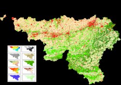
New version of the "ecotope" database available for the Walloon region. More than 80 fields for more than 10e6 polygons: maps.elie.ucl.ac.be/lifewatc…
24 Nov 2016
Feedback on our new #ecotope #biodiversite database of Wallonia is welcome. Play with it on maps.elie.ucl.ac.be/lifewatc…
1
2
24 Nov 2016
24 Nov 2016

The @LifeWatch_WB team publishes their ecotope database of the Walloon region lifewatch.be/en/lifewatch-wb…
LifeWatch WB retweeted

2 Nov 2016
CC: @FORTH_Hellas @cardiffuni @emmmanouella @NicBailly @AlexHardisty @WouterLos @LifeWatchIT @SwLifeWatch @LifeWatchVLIZ @LifeWatch_WB x.com/BioDataJournal/status/…
1 Nov 2016

#LifeWatchGreece launches a Special Paper Collection for Greek #biodiversity research bdj.pensoft.net/browse_user_… @lifewatchgreece #OpenData
5
3
LifeWatch WB retweeted
3 Nov 2016
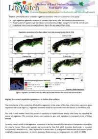
New @LifeWatch_WB Bulletin of Land Surface Dynamics (first half of 2016) released: lifewatch.be/en/bulletins-li…
1
1
9 Jun 2016
New publication on the potential of Sentinel-2 to detect small water bodies, isolated trees and other small objects mdpi.com/2072-4292/8/6/488
1
LifeWatch WB retweeted
30 Jun 2015
4th issue of the Bulletin of Land Surface Dynamics (first half of 2015) is now available online @LifeWatch_WB lifewatch.be/en/bulletins-li…
1
25 Jun 2015
Unusually low vegetation greenness highlighted during the saigas' migration. Does it explain massive death?
2
LifeWatch WB retweeted
10 Mar 2015
Renewed lifewatch.be/ launched! @LifeWatchVLIZ @LifeWatchINBO @LifeWatch_WB @Antonarctica lifewatch.be/news?p=show&id=…
6
1
LifeWatch WB retweeted
4 Feb 2015
Proud to preannounce our next biannual conference: "Empowering #Biodiversity #Research" biodiversity.be/conference20… #biodiversitInformatics
5
1
20 Jan 2015
Fire information updated on uclouvain.be/lifewatch based on the latest MODIS fire products.
2