
#twitch affiliate twitch.tv/MaxLanderBzh 🕹gamer 😻lover. @Papachat_bzh 🥰 linktr.ee/maxlander mail: maxlandercontact@gmail.com
Joined May 2014
- Tweets 30,959
- Following 337
- Followers 283
- Likes 55,774
3,778 Photos and videos


Pinned Tweet

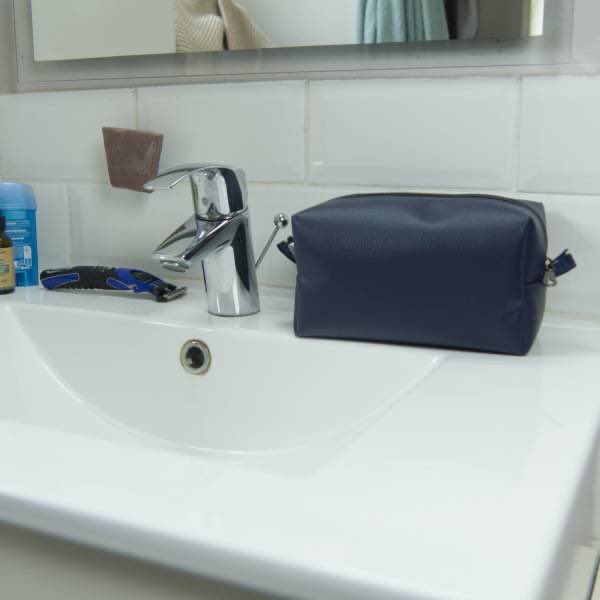
Pour les papounets 😉

La fête des pères approche ! ⏳
Et si je vous proposais 2 ou 3 idées cadeaux ?
Je commence par la toute nouvelle trousse en simili cuir.
Sobre et efficace elle est parfait pour ranger et transporter le nécessaire de rasage !
lescousettesdebobinette.fr/a…


1
2
112
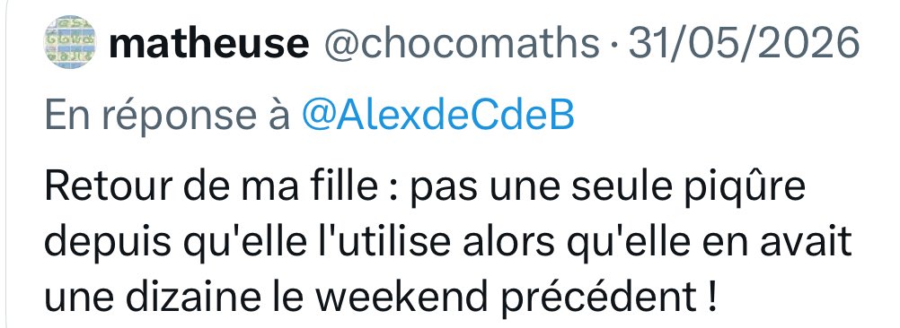
Je confirme, ma sœur et son mec confirment également!
Pour l’anecdote ma sœur en a pris pour mec qui se fait défoncer par les moustiques.
Le lendemain elle a mis aussi car ils s’étaient rabattus sur elle 😂😂😂
Maintenant ils sont tranquilles😉
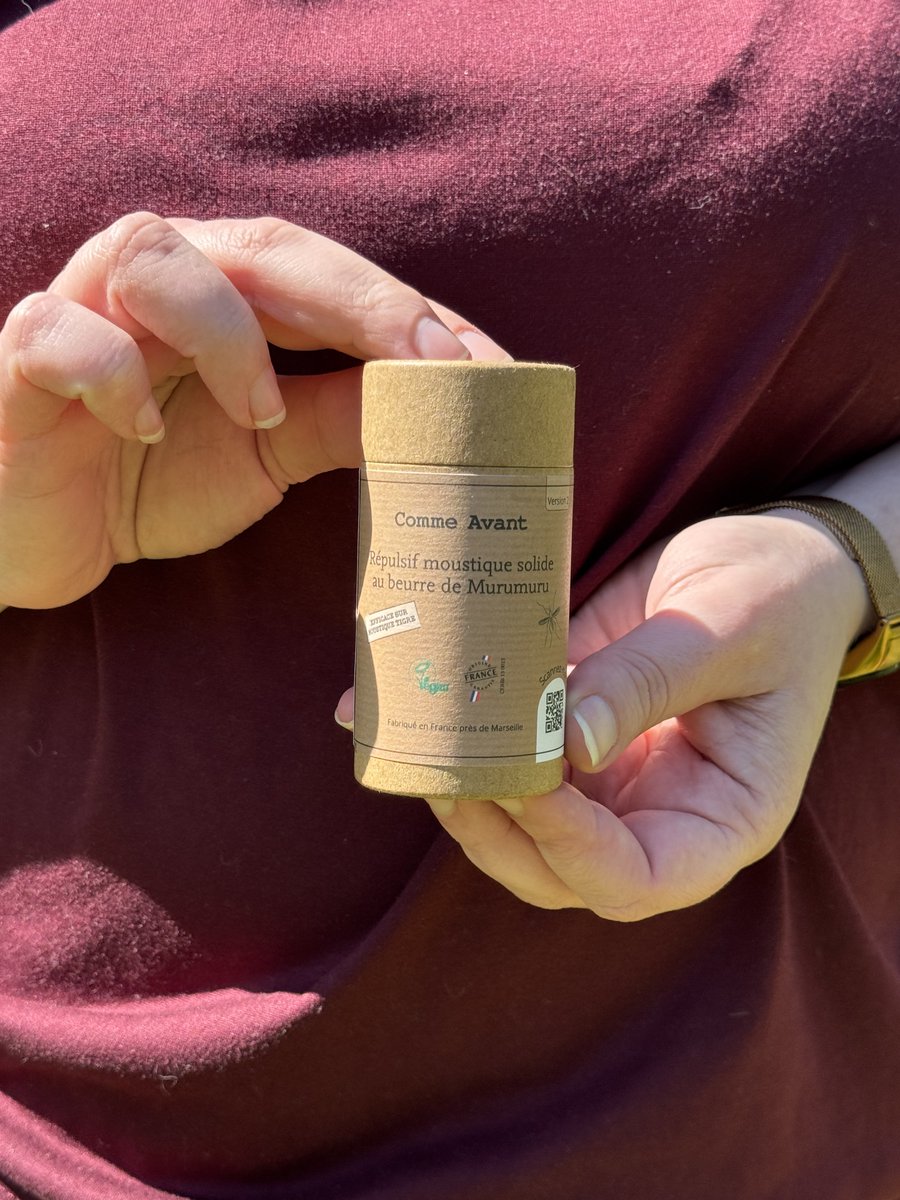
Le répulsif moustique en stick revient en stock dès mardi.
Il y en a déjà plusieurs de réservé donc si vous voulez le votre n’hésitez pas à le commander dès maintenant et il partira dès réception du colis 📦
👉🏻 lescousettesdebobinette.fr/a…
Je vous mets 2 avis sur l’efficacité 👇🏻


1
59
Max Lander / papa chat😺 💸 retweeted

Le répulsif moustique en stick revient en stock dès mardi.
Il y en a déjà plusieurs de réservé donc si vous voulez le votre n’hésitez pas à le commander dès maintenant et il partira dès réception du colis 📦
👉🏻 lescousettesdebobinette.fr/a…
Je vous mets 2 avis sur l’efficacité 👇🏻
2
1
117
Tous les fans de #stargate quand ils voient @AmazonMGMStudio parce qu’ils ne veulent plus faire stargate.
#SaveStargate
21
Fait pas bon d’avoir une fenêtre en Russie 😅
19h

🇷🇺
Le colonel russe Oleg Sokolenko, commissaire militaire des districts Pervomaysky et Proletarsky de Rostov, est décédé après être tombé d’une fenêtre de son propre appartement.
Encore un accident 😔

1
49
Les clefs qui sonnent comme des petites clochettes c’est oui! 🤩
Jun 14

Jour 121, orbite 1873 – La science du dimanche matin avec Sophie, épisode 9 : Chasse aux sons, partie 2.
Avant que quiconque ne se demande pourquoi le TOCA cliquète alors qu’il est éteint… Je ne pouvais évidemment pas l’allumer juste pour cette vidéo, j’ai donc enregistré le son plus tard, pendant des opérations réelles. C’est de loin mon son favori à bord de la Station ! Il s’agit en fait de la vérification de plusieurs valves du Total Organic Carbon Analyzer, une petite merveille d’ingénierie qui teste la qualité de l’eau potable de la Station. Nous recyclons 98% de notre eau à bord – épatant, non ?
🎥 @esa / @NASA
#εpsilon • @esaspaceflight • @esa_fr • @Space_Station • @NASAJohnson • @CNES
32
Pour ceux qui veulent comprendre la maladie derrière ce drame:
TOUT SAVOIR sur le Syndrôme de Noé (et ce sont les chats qui en patissent)
youtu.be/fx5pxlx-hT4
Jun 14

Elle gardait 340 cadavres de chats dans des sacs de croquettes chez elle, une véritable maison de l’horreur découverte à Carcassonne
➡️ l.midilibre.fr/Ki45

1
1
88
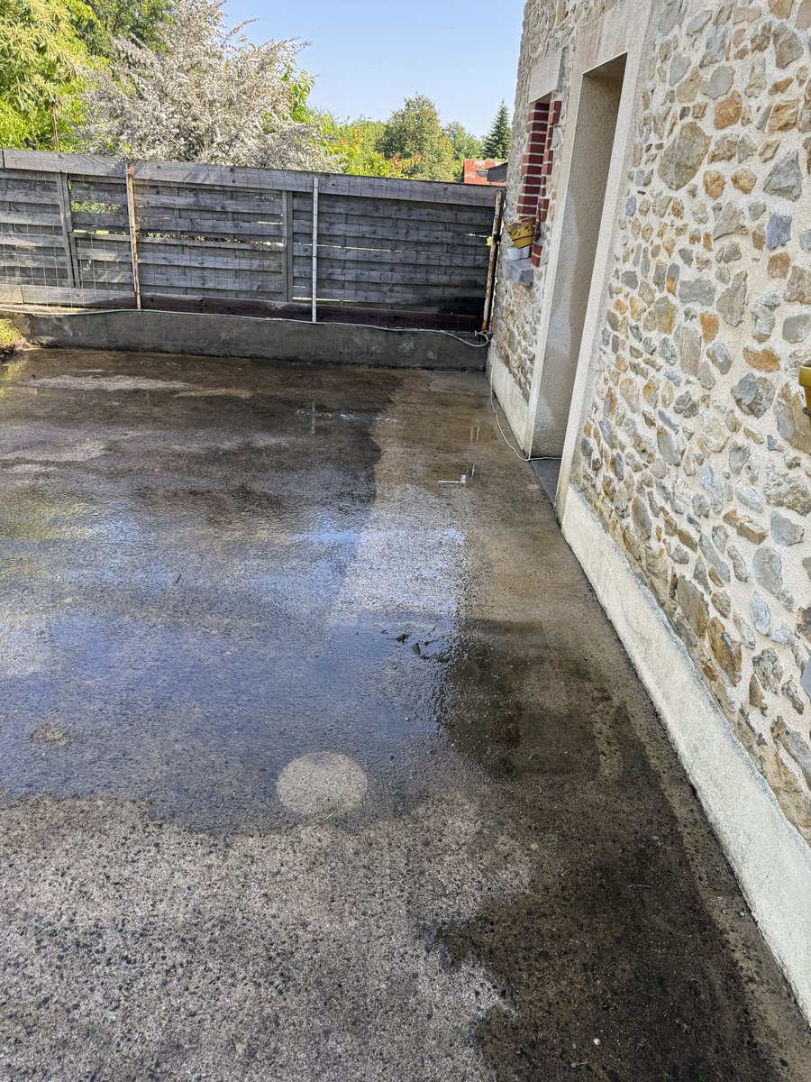
Le nettoyeur haute pression, c’est invention de génie 🤩
Maintenant reste à l’automatiser 😂😂
7
12
2,794
Du coup après, une fois tout remis en place (et après avoir mangé 😂)
2
85
El niño arrive, et ça va faire mal. Très mal.
Accrochez-vous à vos plantations car ça va être compliqué dans les mois à venir!
Jun 13

El Niño has begun, and its development could strongly reshape global weather over the coming months.
The phenomenon occurs when surface waters in the central and eastern tropical Pacific become warmer than usual and the atmosphere begins to respond to that warming.
This is not just a local oceanic anomaly.
Because the tropical Pacific is one of the main engines of Earth’s climate system, a change there can alter wind patterns, rainfall, storm tracks, drought risk and global temperatures.
Current observations show that the ocean and atmosphere are now coupled in a way consistent with El Niño. Sea surface temperatures are above average across the central and eastern equatorial Pacific, the Niño-3.4 region has crossed the El Niño threshold, and wind patterns over the tropical Pacific have shifted.
Forecast models suggest that this event is likely to strengthen through late 2026 and into the Northern Hemisphere winter of 2026-27. There is a meaningful possibility that it could become a very strong El Niño, sometimes informally called a “super El Niño,” although that outcome is not guaranteed.
If it does intensify as projected, the consequences could be widespread. El Niño often increases the likelihood of wetter conditions in parts of the southern United States and the eastern Pacific side of the Americas, while raising drought risk in regions such as Indonesia, parts of Australia, southern Africa and the Sahel. It can also suppress Atlantic hurricane activity by increasing wind shear over the tropical Atlantic, while shifting storm and rainfall patterns elsewhere.
These are not deterministic predictions for every country or region, but changes in probability: El Niño loads the dice toward certain kinds of weather extremes.
A very strong El Niño would be especially important because it is occurring in a world that is already unusually warm. El Niño naturally releases additional ocean heat into the atmosphere, so when it happens on top of human-driven global warming, it can push global temperatures even higher and increase the risk of heatwaves, marine heat stress, coral bleaching, drought, crop disruption and intense rainfall in vulnerable regions.
Previous very strong El Niño events have been associated with major climatic and humanitarian impacts, but each event has its own structure, timing and regional footprint.
The most careful way to understand this is not as a single global disaster forecast, but as a major shift in climate risk. The planet’s background temperature is higher than it used to be, the oceans contain more heat, and the atmosphere can hold more moisture.
A strong El Niño in that context can amplify extremes that would already be concerning. The coming months will depend on how strongly the tropical Pacific continues to warm and how the atmosphere responds, but the signal is now clear enough for governments, farmers, water managers, health systems and disaster agencies to pay close attention.
@NOAA

48
Et si la solution c’était de faciliter l’installation d’ Anthropic en Europe ? Vu que Trump veut leur pourrir la vie, profitons en!
Jun 13

Anthropic suspend son IA la plus puissante, sous contrainte du gouvernement américain l.franceinfo.fr/cDM
1
128
On est pas thanatopracteur ni archéologue. Désolé
Jun 13

C’est marrant, je ne vous vois pas trop commenter les épreuves de latin et de grec ancien du Bac.
1
50
Littéralement le principe croque-mort 😅😂

1
3
238
Max Lander / papa chat😺 💸 retweeted

Jun 13
Voilà.
Donc les associations qui servent et dont les gens veulent n'ont nul besoin d'être subventionnées : les fonds privés suffisent.
On peut donc arrêter de taxer les gens au niveau local pour subventionner tout et n'importe quoi d'inutile ou sans rapport avec le territoire.
Jun 11

Le RN coupe 3 000 € au Planning familial de Carpentras. Réponse en 24h : plus de 4 000 € de dons.
Voilà la vraie réponse citoyenne.
La société a répondu : on n’efface pas les droits des femmes ni la solidarité. Le RN est un danger pour nos droits.
franceinfo.fr/politique/fron…
37
140
1,355
65,712

L'🇪🇺 a versé au secteur viticole sud africain une subvention de 15 000 000 € en faveur de la restructuration pour la diversité et l'inclusivité du secteur 😳.
L'🇪🇺 fait n'importe quoi avec notre argent.
24
Le décalage de référentiel pour les gens devient important. Désormais s’ils n’ont pas 25° tout le mois c’est pas normal, alors que c’est en fait son absence de jour « frais » qui ne l’est pas…
Acclimatation dirons-nous…

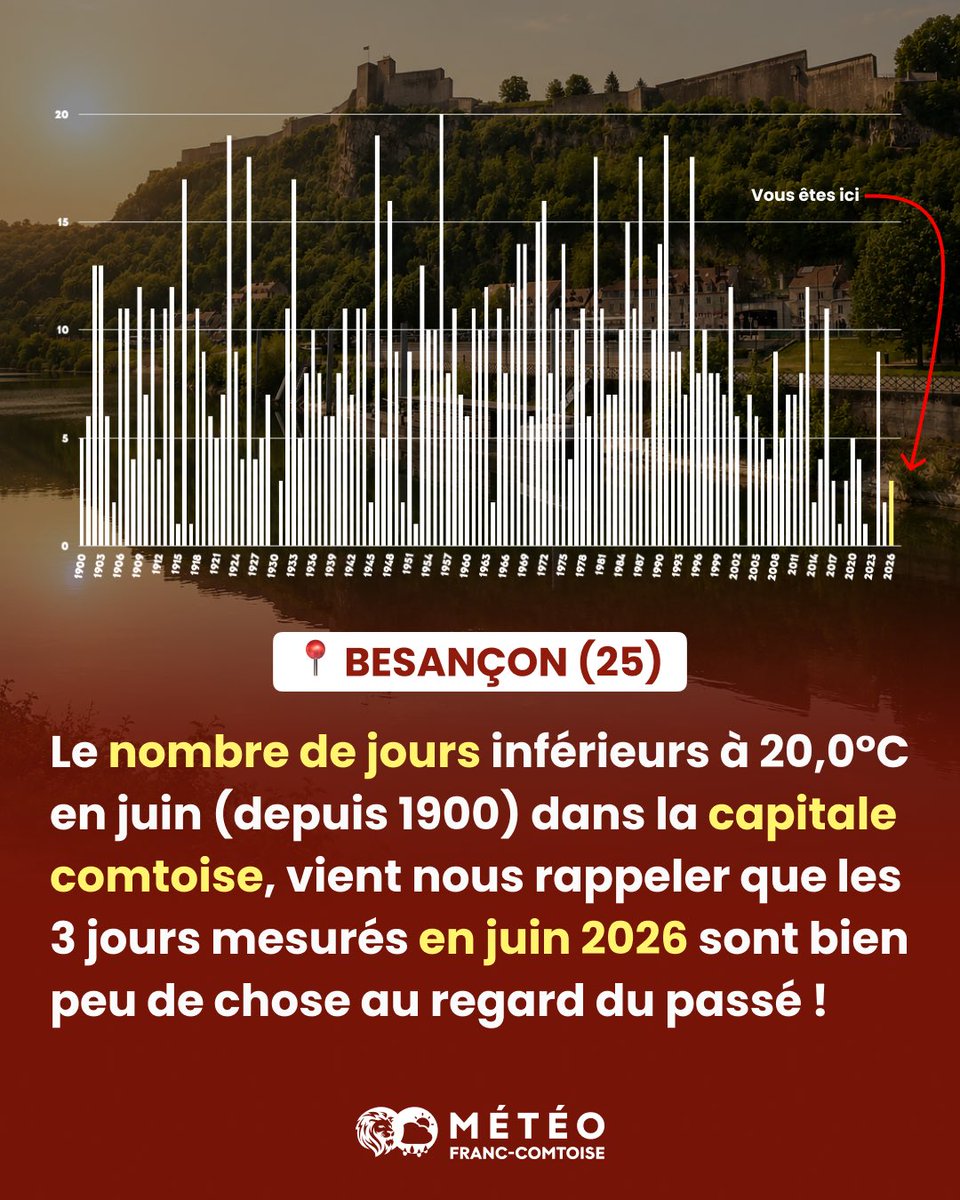
🥶 DU FROID EN JUIN ?!! Si cela vous choque, vous manifestez une évolution de vos repères météo !😉
Bonjour à tous ! Voilà 10 jours que la France voit ses conditions météorologiques mitigées ou maussades. Suffisant, déjà, pour lire un tas de bêtises sur la toile.
Je me suis donc amusé à regrouper toutes les fois où Besançon (25) et sa station météorologique (en place depuis 1885) ont enregistré moins de 20,0°C en juin.
⚠️ Bilan ÉDIFIANT : les mois de juin du XXème siècle apportaient couramment 5-10 jours inférieurs à 20°C (jusqu’à 15-20 jours en juin 1923, 1946, 1956 ou 91).
En 2026, les 3 jours (enregistrés le 4, 9 puis 10 juin) s’inscrivent dans une tendance à la "raréfaction" des journées « fraîches » de juin. Pourtant cette semaine, plusieurs internautes estimaient déjà qu’il n’était « pas normal » d’avoir aussi peu de chaleur à cette période de l’année. Une réaction qui illustre surtout l’évolution de nos repères météorologiques : nous nous sommes progressivement habitués à des étés de plus en plus chauds. D’ailleurs, 9 des 10 étés les plus chauds observés en France ont été enregistrés au cours des vingt dernières années, malgré plus d’un siècle de mesures. Dans ce contexte, quelques journées fraîches en juin ne remettent pas en cause la tendance de fond, même si certains n’hésitent pas à les utiliser pour alimenter la confusion autour du réchauffement climatique.
De quoi, je l’espère, remettre quelques pendules météorologiques à l’heure 😉
26
Max Lander / papa chat😺 💸 retweeted
Il n’en reste plus qu’un exemplaire de chaque !
👉🏻 lescousettesdebobinette.fr/4…


1
1
3
214
C’est pour ça qu’il y a le répulsif anti-moustique chez les cousettes de bobinette
(Ça fonctionne très très bien promis!)
lescousettesdebobinette.fr/a…
Jun 11

Chaque jour de printemps qui passe nous rapproche un peu plus des moustiques. 🦟
Méditez ça.
1
30
Max Lander / papa chat😺 💸 retweeted

Jun 12
Mais c'est quoi votre problème avec le nucléaire LFI putain ?
1,89 million de m³ au total depuis les débuts du nucléaire en France.
Ça paraît énorme non ?
Allez, j'suis pas chien, on va décomposer pour ceux que ça décomposent de lire ça.
95 % de la radioactivité est concentrée dans ce que l'on appelle les déchets haute activité (HA). Leur volume cumulé depuis l'origine est de 3 650 m³.
C'est une piscine olympique.
Pour alimenter 70 % de l'électricité nationale depuis 50 ans.
Ramené à l'individu c'est 0,02 cm³ par habitant et par an de déchets HA produits.
Le volume d'un dé à jouer.
Ces déchets sont intégralement localisés, inventoriés, confinés, surveillés.
Si tu prends du CO₂ du charbon, les métaux lourds des panneaux PV en fin de vie, des résidus de combustion du gaz que personne ne compte avec précision...
Pire, ils se dispersent librement dans l'air, les sols et même nos petits poumons.
Le nucléaire est la filière énergétique la fiable et la efficace... Et même la écologique.
Ne vous en déplaise Manuel Bompard.
Merde à la fin.
206
745
2,995
127,238
C’est ça en spé math au bac? Ho merde…
Si j’avais eu ça en 2000 j’aurais pas eu un rattrapage 😂😂

173