This account has been sunset. For news on NASA networking and navigation capabilities, check out @NASASpaceOps, @NASA_Technology, and other NASA accounts.
Important update: This account is being consolidated, but we’ll continue to post about our networking and navigation capabilities over at @NASASpaceOps, @NASA_Technology, and on mission-specific accounts.
Learn about NASA's social media consolidation: go.nasa.gov/4l5Ga3t
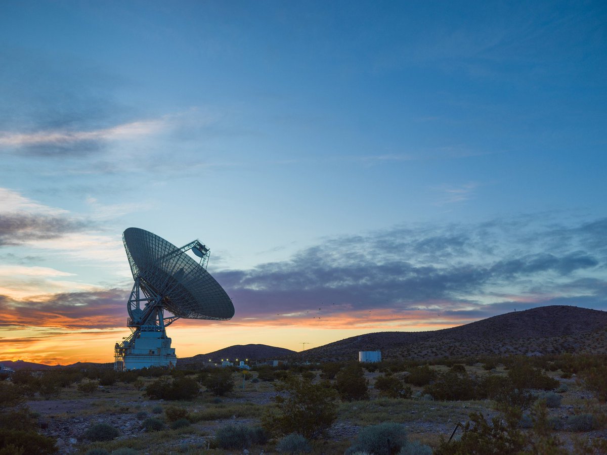
ALT This sunset photo shows Deep Space Station 14 (DSS-14), the 230-foot-wide (70-meter) antenna at the Goldstone Deep Space Communications Complex near Barstow, California, part of NASA's Deep Space Network. The network's three complexes around the globe support communications with dozens of deep space missions. DSS-14 is also the agency's Goldstone Solar System Radar, which is used to observe asteroids that come close to Earth. Credit: NASA/JPL-Caltech
SCaN recently advanced @NASA’s efforts to commercialize space communications services by issuing a Request for Information for insight into industry’s Earth proximity space relay services.
Respond to the solicitation before July 11, 2025, at 5:00 PM EDT: bit.ly/4kJOzJo.
Venturing to the Moon & Mars will require stellar comm & nav services. @NASA selected Intuitive Machines to develop commercial lunar relays. These will allow assets & astronauts on the Moon to stay in near-constant contact with Earth.
Learn more: go.nasa.gov/4aY1ZOv
PACE, AQUA, XRISM, SDO, & many more missions rely on our networks to get their data home.
How do we do it?
With a global system of gov & commercial antennas. Now, we’re adding more commercial antennas, so we can increase the Near Space Net’s capacity. go.nasa.gov/3ZTnYB5
With TDRS retiring, we’ve funded six commercial demos for near-Earth space relays. Each company is bringing their own unique approach and will demonstrate their capabilities by 2027.
Who’s participating? Viasat, Inmarsat, SpaceX, SES, Kuiper, and Telesat. bit.ly/3RRGBSq
ALT An artist's rendering of what a commercial relay network in low Earth orbit could look like. The colors scale blue, grey, white, and black. In the bottom right corner, the Earth is shown with white dots to indicate activity. Relay satellites hover "above" Earth.
But why do we need space relays?
Relays enable spacecraft that cannot see an antenna on Earth to transmit data home. Many missions transmit their data this way, including the @Space_Station, @NASAHubble, Fermi, Swift, and more.
With commercial relays, NASA will be able to support more science and exploration missions transmitting data about our planet, the Moon, Mars, and the solar system beyond.
Watch a recording of a recent town hall to learn more: go.nasa.gov/4jfP5hj
Earlier this month, we met with the aerospace industry to discuss our plans for flying out our Tracking and Data Relay Satellite (TDRS) fleet and embracing commercial satellite communications capabilities.
Watch a recording of the meeting: go.nasa.gov/4mhYA2g
0:10
7
11
703
ARCHIVED NASA Space Communications and Navigation retweeted
Upgrade achieved. ✔
The @NASASCaN team upgraded the Near Space Network to support the SPHEREx mission. SPHEREx is mapping the sky and offering new insight into what happened a fraction of a second after the big bang. Learn more: go.nasa.gov/3GPmBNU
ALT NASA’s SPHEREx observatory separates from its spacecraft after launch on March 11, 2025. The pale blue marble of Earth fills the upper right, its surface coated in clouds. A circular base with a flat, rectangular solar panel attached to it faces the camera. A large white cone extends from that, its opening facing the darkness of space. Metal hardware along the bottom edge of the image shows the portion of the launch vehicle that carried SPHEREx to orbit, where the camera is mounted. The image is watermarked “Credit: NASA.”
SPHEREx is mapping the sky & surveying over 450 million galaxies!
To support SPHEREx, SCaN partnered with a commercial company & upgraded Near Space Network antennas. Now, SPHEREx can transmit ~20 gigabytes of data each day. bit.ly/4m41bwC
0:27
4
34
137
16,030
ARCHIVED NASA Space Communications and Navigation retweeted
Let the cosmic mapmaking begin! ✨
SPHEREx has started its science mission, scanning the entire sky in 102 infrared wavelengths to chart the positions of hundreds of millions of galaxies and uncover the universe's hidden secrets. go.nasa.gov/3EPrS7u
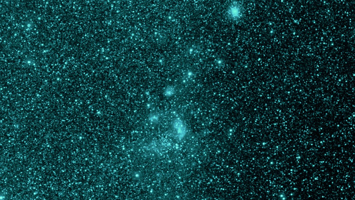
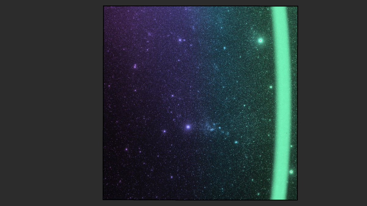
ALT A portion of the sky is shown in an infrared wavelength similar to the color teal. This was captured by the SPHEREx space telescope as it scanned the sky and began its science operations. The portion of sky is dotted with hundreds of thousands of various sized stars and galaxies.
Taters the Cat won a Webby! 🐱
@NASA transmitted a video of Taters from the Psyche mission to Earth, testing laser comm links in deep space. The video traveled over 19 million miles & demonstrated laser comm as a viable technology for future exploration. bit.ly/445iVRQ
The results are in: We won 12 #Webbys, six of which were People’s Voice Awards! Thank you for voting for us – we love sharing space with you. go.nasa.gov/42Hxo3P
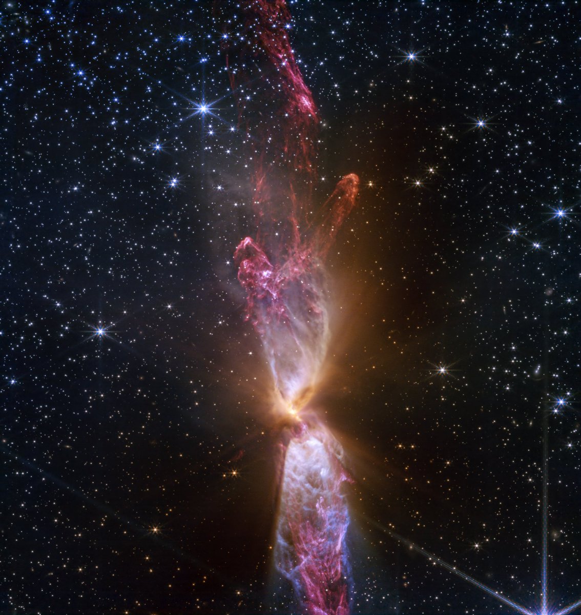
ALT At the center is a thin vertical cloud known as Lynds 483 that is shaped like an hourglass with irregular edges. At lower center are two discrete bright white, tiny blobs of light that have raced away from the hidden central stars. The top lobe shows a more prominent orange U-shape. Orange bleeds into light purple, and brighter pink at its edges. Some background stars are visible through sections of this lobe. Higher up, there is an orange arc. Some brighter pink material extends to the top edges near the center. In the lower lobe, less orange is visible. More opaque light purple is in its top third, rippling out into semi-transparent blues and pinks. The lower lobe has more texture. V-shapes left and right of the lobes are darkest, and the background stars in these areas appear orange. Elsewhere, the black background of space is clearer, speckled with tiny white stars and faint orange galaxies. Credit: NASA, ESA, CSA, STScI
3
13
26
2,335
ARCHIVED NASA Space Communications and Navigation retweeted
Thirty-five never looked better!
Take a tour through Hubble's 35th anniversary images, narrated by senior project scientist Dr. Jennifer Wiseman.
Explore more here: go.nasa.gov/4cIjrY2
Today, @NASAHubble celebrates 35 years in orbit!
The historic mission, which relies on our Near Space Network to transmit data to Earth, has transformed our understanding of the universe and led to new discoveries. Learn more here: go.nasa.gov/4lJ3kO4
On April 20th the #LucyMission flew by asteroid Donaldjohanson & surveyed the asteroid using its 3 science instruments. Lucy’s science data is transmitted home through our Deep Space Network, and will help us study how planets in our Solar System were formed! go.nasa.gov/4cHZSPL
ALT The asteroid Donaldjohanson as seen by the Lucy Long-Range Reconnaissance Imager (L’LORRI) on NASA’s Lucy spacecraft during its flyby. This timelapse shows images captured approximately every 2 seconds beginning at 1:50 p.m. EDT (17:50 UTC), April 20, 2025. The asteroid rotates very slowly; its apparent rotation here is due to the spacecraft’s motion as it flies by Donaldjohanson at a distance of 1,000 to 660 miles (1,600 to 1,100 km). The spacecraft’s closest approach distance was 600 miles (960 km), but the images shown were taken approximately 40 seconds beforehand, the nearest ones at a distance of 660 miles (1100 km).
1
7
22
1,517
ARCHIVED NASA Space Communications and Navigation retweeted
See Earth through our eyes. 🌎
NASA studies our home planet like no one else, observing Earth from land, air and space for more than 60 years. Happy #EarthDay!
It’s #EarthDay! @NASAEarth-observing mission Landsat-9 uses SCaN’s Near Space Network to transmit over 1,400 images back to Earth every day.
Now, you can use Landsat imagery to write your name. Check it out: go.nasa.gov/3Gfh0A3