This is the official page of NorCal Skywarn,N6CSW. Follow for weather and important weather related emergency announcements. Contact: info@norcalskywarn.org
Starting today flows from Keswick Dam into the Sacramento River will increase to 11,000 cfs. Keswick Dam is part of the Central Valley Project that moves water from Shasta Reservoir in the north as far south as Bakersfield. Please use caution along the river!
This is the view from Mt Rose Highway. It's another chilly day with rain and snow showers around the Sierra and western NV. Mountain roads are wet or snow covered. Warmer weather returns Monday, though it could turn chilly and wet again next weekend.
4/26/25 9:10am Update:
#Snow started shortly after midnight and we have accumulated 4.5" (11.5 cm) so far with light to moderate rates.
We expect more snow through tomorrow with the heaviest rates being overnight tonight and another 5-10" at the lab.
#CAwx#CAwater
The @kcranews weather team is growing!
Meet meteorologist Ophelia Young. She just moved back to NorCal after spending the last ten years forecasting in Las Vegas.
Weโre excited sheโs here!
May have some rain this weekend with Snow โ๏ธ in the mountains. Possible chain controls for those traveling over Interstate 80 and Highway 50. Keep them handy just in case. Heaviest rain looks like South of Highway 50. #CAWX#SierraWx
Kick off your week by checking out these free, online weather courses! The class tonight is on Severe Thunderstorms.โ๏ธ The entire #weather101 lineup can be seen here - Register today! weather.gov/ohx/weather101
Active weather is expected to continue throughout the day into the evening. Expect moderate to heavy mountain snow, with Valley and foothill rain showers and scattered afternoon to evening thunderstorms. #CAwx
ALT Model precipitation loop for today, Tuesday April 1, 2025.
Both Highway 50 and Interstate 80 are a mess with Snow and spin outs. Traffic being held in both East and Westbound directions. #CAWx#SierraTravel#TahoeWx#SierraWx
๐ฉA Beach Hazards Statement is in effect from 8 AM Sunday - 11 PM Tuesday for Pacific Coast beaches. While warm conditions can be expected on land, the Pacific Ocean is 51ยฐ-57ยฐ and will not be your friend during this time with an increased risk of sneaker waves and rip currents๐ฉ
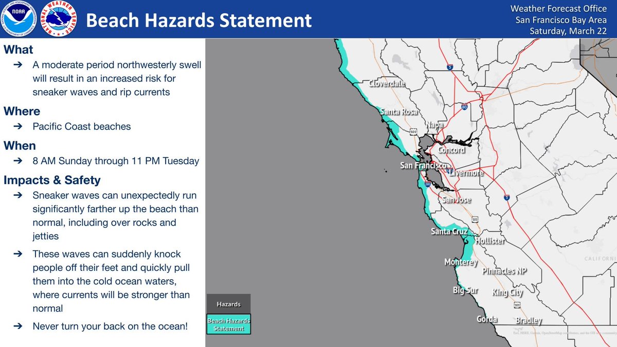
ALT What: A moderate period northwesterly swell will result in an increased risk for sneaker waves and rip currents
Where: Pacific Coast beaches
When: 8 AM Sunday through 11 PM Tuesday
Impacts and Safety: Sneaker waves can unexpectedly run significantly farther up the beach than normal, including over rocks and jetties, These waves can suddenly knock people off their feet and quickly pull them into the cold ocean waters, where currents will be stronger than normal, Never turn your back on the ocean!
Thunderstorm chances (15-35%) return on Wednesday to the northern & central Sacramento Valley, adjacent foothills, and the Sierra. Impacts will include lightning, gusty winds, brief heavy rain, and small accumulating hail. Remember, if you see a flash, dash inside! #CAwx
ALT Valid March 23, 2025. 15 to 35% probability for thunderstorms Wednesday in the northern and central Sacramento Valley and adjacent foothills, and the Sierra. Impacts: lightning, gusty winds, brief heavy rain, and small accumulating hail.