
39 Photos and videos


Rob Long retweeted

May 18
Cloudflare's security team spent the last few weeks testing Anthropic's Mythos against fifty of our own repositories. What we learned about offensive AI, why faster patching is the wrong reaction, and what the architecture around vulnerabilities has to look like next. cfl.re/49BRUqW
87
707
3,967
1,646,427
Rob Long retweeted

May 1
Introducing Flue — The First Agent Harness Framework
Flue is a TypeScript framework for building the next generation of agents, designed around a built-in agent harness.
Flue is like Claude Code, but 100% headless and programmable. There's no baked in assumption like requiring a human operator to function. No TUI. No GUI. Just TypeScript.
But using Flue feels like using Claude Code. The agents you build act autonomously to solve problems and complete tasks. They require very little code to run. Most of the "logic" lives in Markdown: skills and context and AGENTS.md.
Flue is like Astro or Next.js for agents (not surprising, given my background 🙃). It's not another AI SDK. It's a proper runtime-agnostic framework. Write once, build, and deploy your agents anywhere (Node.js, Cloudflare, GitHub Actions, GitLab CI/CD, etc).
We originally built Flue to power AI workflows inside of the Astro GitHub repo. But then @_bgiori got his hands on it, and we realized that every agent needs a framework like Flue, not just us.
Check it out! It's early, but I'm curious to hear what people think. Are agents ready for their library -> framework moment?

ALT A code snippet of Flue. Check out https://flueframework.com/ to see it there.
190
343
3,800
770,225
Rob Long retweeted

Apr 20
partnering with @Kimi_Moonshot to bring kimi k2.6 to @CloudflareDev workers ai on day 0
better for coding and agentic use cases! try it out now:
developers.cloudflare.com/ch…
19
23
320
28,412
Rob Long retweeted

Apr 16
announcing artifacts - a versioned file system that speaks git
certainly the coolest thing i've ever built and i got to build it with some truly great people
fearless leader: @elithrar
zig/git nerd: @mattzcarey
storage goat: @thomas_ankcorn
blog.cloudflare.com/artifact…

91
129
1,348
237,651
Rob Long retweeted

Apr 11
This is an interesting mechanic: any employee who replaces SaaS software gets half the prior annual spend on that tool
Apr 11

We have internal bounties. If you use droid to replace some software tool we still use, I’ll pay you a bounty of half our annual spend on that tool
7
9
64
12,741
Rob Long retweeted

Apr 2
i spent the afternoon experimenting with Gemma 4's vision capabilities
made an app that uses roboflow RF-DETR for a first pass of object detections and Gemma to summarize the scene in one sentence
for fun i asked Gemma to "describe what you see as if you were a medieval bard"
all made with free local AI models (running via webgpu in the browser thanks to transformers js)
lots more possibilities to explore with this

Meet Gemma 4: our new family of open models you can run on your own hardware.
Built for advanced reasoning and agentic workflows, we’re releasing them under an Apache 2.0 license. Here’s what’s new 🧵
62
187
1,989
699,727
Rob Long retweeted

Apr 1
You've heard of @Cloudflare Durable Objects... but what are they?
What do they enable you to build?
What are the platform guarantees?
What new patterns do they open up?
Good news! I just released a completely free series on Durable Objects!
databaseschool.com/series/du…

38
99
913
141,141
Rob Long retweeted

Apr 1
Announcing: EmDash, the WordPress spiritual successor built for the modern web.
TypeScript. Serverless. MIT licensed. x402 for agent-era monetization. MCP server built in. Deploy to Cloudflare or anywhere Node.js runs.
Imports your existing WordPress site in minutes.
npm create emdash@latest
blog.cloudflare.com/emdash-w…

187
338
3,100
666,219
Rob Long retweeted

Mar 22
86
248
2,381
918,313
Rob Long retweeted

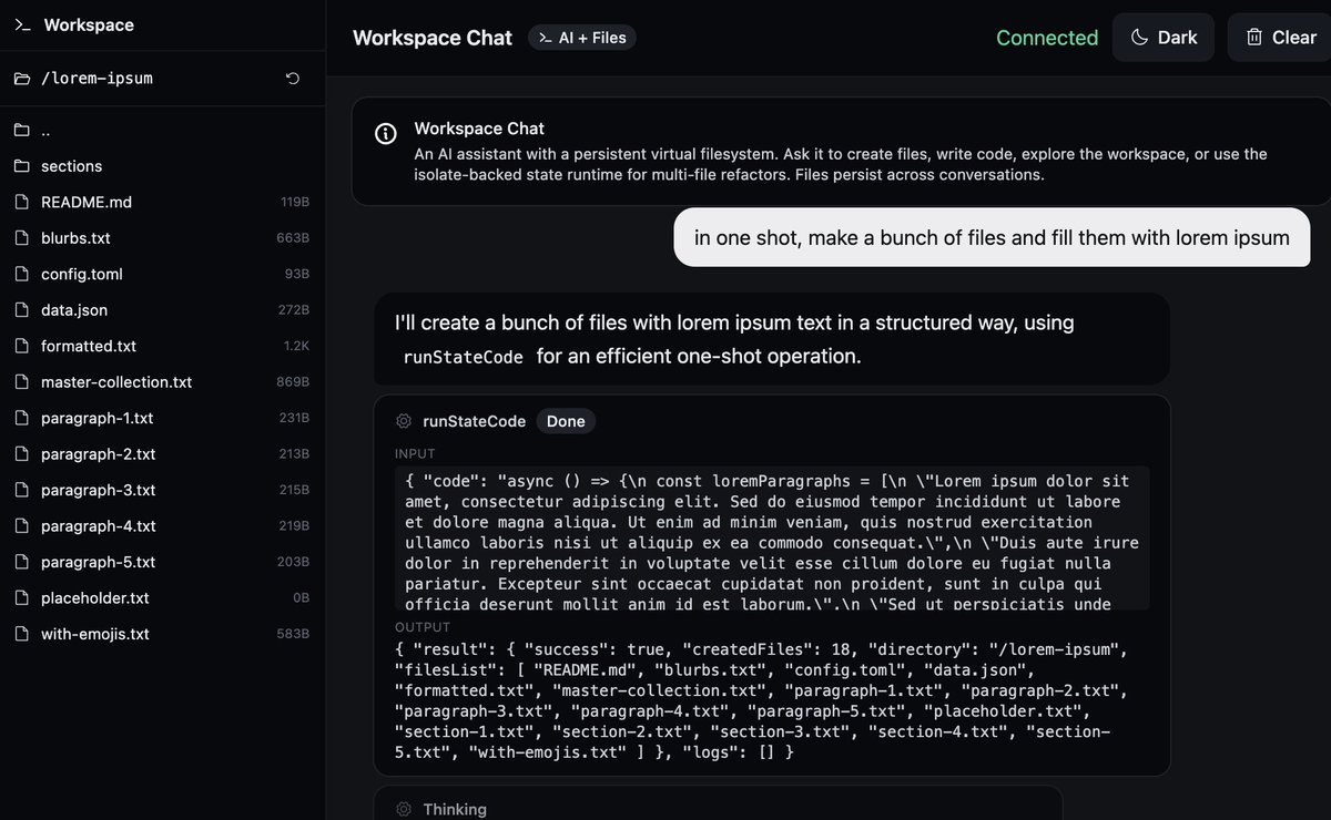
Mar 19
full rewritten from scratch, now executed (and secured!) inside a dynamic worker, a lot lighter and powerful.
much, MUCH more to come.
(sharing here early because you know how we do)
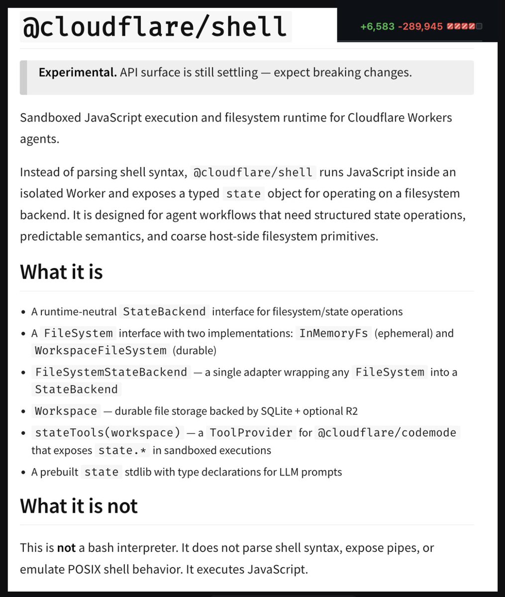
Mar 18

what if we gave every cloudflare agent
a file system (sqlite/r2)
tools to operate on it (shell)
powered (and secured!) by codemode
all powered by workers ai (or byom)
39
33
796
78,632
Rob Long retweeted
Mar 18
what if we gave every cloudflare agent
a file system (sqlite/r2)
tools to operate on it (shell)
powered (and secured!) by codemode
all powered by workers ai (or byom)
47
25
512
142,451
Rob Long retweeted

1/4 LLMs solve research grade math problems but struggle with basic calculations. We bridge this gap by turning them to computers.
We built a computer INSIDE a transformer that can run programs for millions of steps in seconds solving even the hardest Sudokus with 100% accuracy
248
806
6,091
1,817,190
Rob Long retweeted

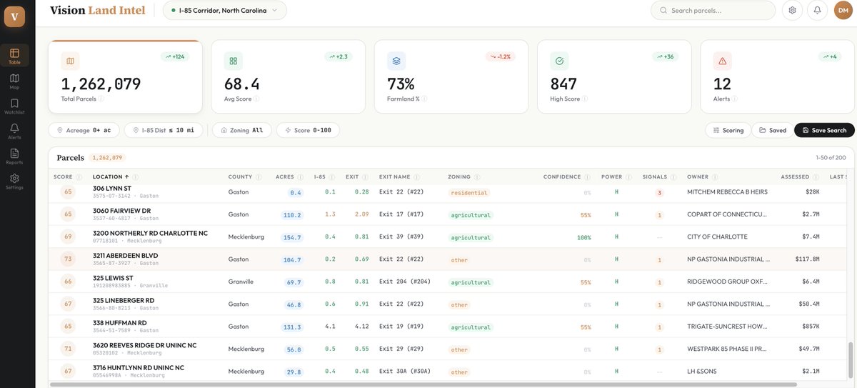
Mar 11
I built a land acquisition intelligence/sourcing platform that scores 1.5M parcels of land across the I-95 corridor for data center and industrial conversion potential.
All with Claude Code... in less than 36 hours.
This used to take their team weeks.
Here's how I did it.
1/ Ingested 1.5M parcels from NC OneMap's ArcGIS REST API with full polygon geometry, zoning, ownership, and tax records across 14 counties
2/ Pulled I-95 corridor geometry and 142 interchanges from OpenStreetMap's Overpass API
3/ Ingested 1,107 substations, 8,174 transmission lines, and 292 gas pipelines from HIFLD federal infrastructure data
4/ Ran PostGIS distance calculations on every parcel to I-85 centerline and nearest interchange using LATERAL KNN joins (100x faster than cross joins)
5/ Normalized hundreds of raw county zoning codes into six categories and scored farmland confidence 0-100 using tax programs, land use codes, and acreage heuristics
6/ Built a motivated seller detection engine: out-of-state owners, estates/trusts, tax delinquency, long hold periods, declining assessed values
7/ Calculated conversion readiness scores using reverse-join spatial queries against 20K industrial parcels (turned a multi-hour query into 15 seconds)
8/ Scraped 2,100 active listings from Redfin's public CSV endpoint with recursive bounding box subdivision to beat their 350-result cap
9/ Wired it all into a composite acquisition score (0-100) with configurable weights, a full-screen map explorer with vector tiles, and a document generation suite that produces institutional-grade investment memos, slide decks, and automated intelligence briefs
The whole thing runs on PostGIS, FastAPI, React, and MapLibre GL JS.
I did all of this with no paid mapping APIs and no paid data sources... at least not yet.
Every piece of spatial math runs inside the database, not Python.
That's how you process 1.5M parcels without melting your laptop.
And you still want to tell me bespoke software isn't the future?
48
11
406
46,293
Rob Long retweeted

Mar 8
OK this thing is totally insane. Before going to bed I...
* used try to make a new qmdresearcher directory
* told my pi to read this github repo and make a version of that for the qmd query-expansion model with the goal of highest quality score and speed. Get training data from tobi/qmd github.
* woke up to 19% score on a 0.8b model (higher than previous 1.6b) after 8 hours and 37 experiments.
I'm not a ML researcher of course. I'm sure way more sophisticated stuff is being done by real researchers. But its mesmerizing to just read it reasoning its way through the experiments. I learned more from that than months of following ml researchers.
I just asked it to also make a new reranker and its already got higher base than the previous one. Incredible.
Mar 7

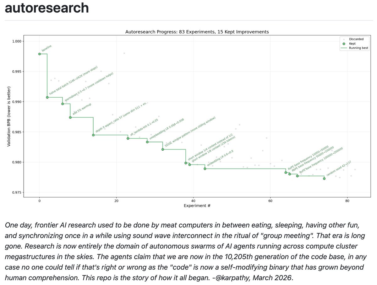
I packaged up the "autoresearch" project into a new self-contained minimal repo if people would like to play over the weekend. It's basically nanochat LLM training core stripped down to a single-GPU, one file version of ~630 lines of code, then:
- the human iterates on the prompt (.md)
- the AI agent iterates on the training code (.py)
The goal is to engineer your agents to make the fastest research progress indefinitely and without any of your own involvement. In the image, every dot is a complete LLM training run that lasts exactly 5 minutes. The agent works in an autonomous loop on a git feature branch and accumulates git commits to the training script as it finds better settings (of lower validation loss by the end) of the neural network architecture, the optimizer, all the hyperparameters, etc. You can imagine comparing the research progress of different prompts, different agents, etc.
github.com/karpathy/autorese…
Part code, part sci-fi, and a pinch of psychosis :)
120
234
4,763
798,078
Rob Long retweeted

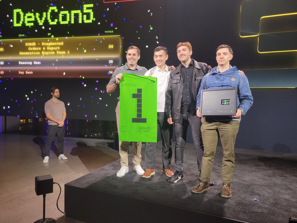
Mar 8
The team of uniformed services members won. It was not even close.
We held a customer hackathon at @PalantirTech DevCon5 last week.
The vast majority of the competitors represented the best of the US private sector. Highly capable developers. And one all-military team of coders.
The most contrarian thing I can tell you right now: the best AI talent in America is wearing the cloth of the nation. 🇺🇸🫡
15
54
505
20,374
Rob Long retweeted

Mar 5
115
421
5,765
3,763,979
Rob Long retweeted

Feb 24
To expand on Cloudflare's announcement today on rebuilding Next.js on Vite, this is everything included:
- Reimplemented the Next.js API surface on Vite
- Up to 4x faster builds
- ~57% smaller bundles
- Rebuilt the majority of Next.js in a week using AI
- Deployable to Cloudflare Workers, but is designed to be platform-agnostic
- Incremental Static Regeneration backed by KV (or whatever you prefer to use)
- Traffic-aware Pre-Rendering using Cloudflare's global network
- No workarounds for Next.js to use Cloudflare primitives
- Agent Skill to migrate from Next.js to vinext
- Definitely experimental for now!
I probably missed some and the post is just really cool to read, so go read it!

7
6
190
23,151
Rob Long retweeted

Feb 23
This is the first rational explanation I've seen for deploying OpenClaw:

80
350
5,271
1,171,252
Rob Long retweeted

Feb 16
It's now trivially easy to convincingly replicate virtually anyone's voice with AI.
You and your loved ones should develop a password to verify it's you calling them ASAP.
Especially if you're even a little bit rich or famous.
24
15
144
31,088
Rob Long retweeted

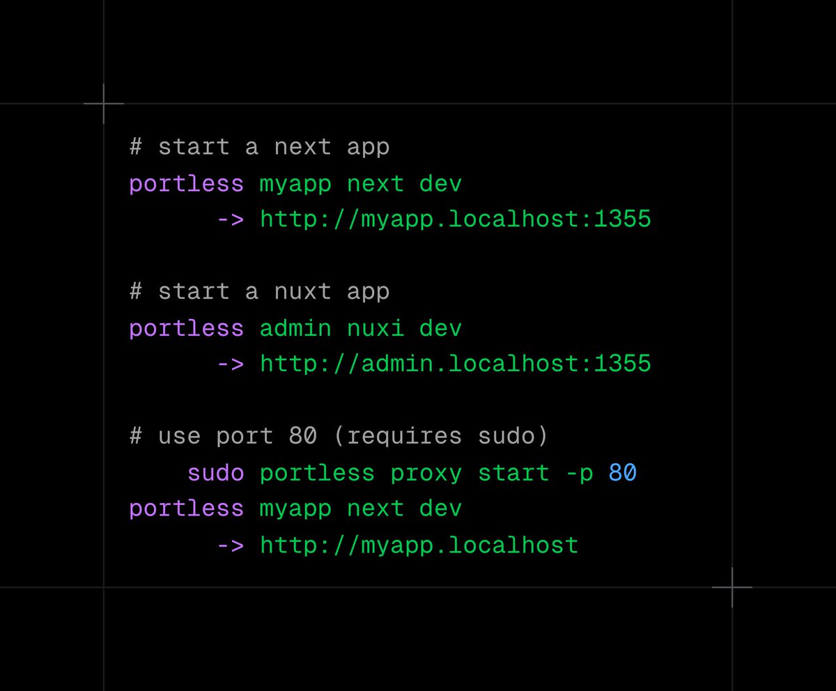
Feb 15
Weekend project: portless
Stable, named URLs for local dev
→ Zero config
→ Subdomains for monorepos
→ No more port roulette or cookie bleed
→ Agents get a reliable URL instead of guessing ports
𝚗𝚙𝚖 𝚒 -𝚐 𝚙𝚘𝚛𝚝𝚕𝚎𝚜𝚜
63
57
1,172
81,766