At the direction of Governor Newsom, Cal OES is working with local agencies to preposition firefighting personnel and equipment in six counties ahead of Red Flag fire weather to ensure assets are in place to respond quickly to new fires. Learn more: wp.me/pgM8my-12ov
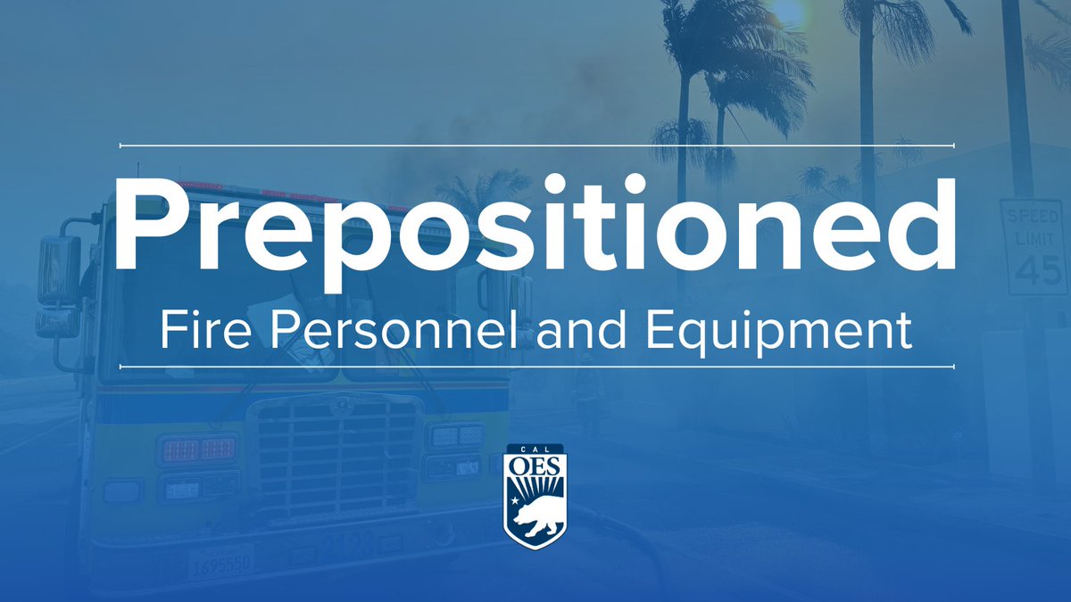
ALT A Cal OES fire engine with a palm tree blowing in the wind with smoke from a fire. Text reads prepositoned fire personnel and equipment with the Cal OES logo.
Hey @CityofSSF San Mateo County's draft Local Hazard Mitigation Plan (LHMP) is open for public comment. Tell us, what's the biggest hazard risk where you live?
- Public comment period: May 15 to June 15
- Read the draft plan and submit feedback: bit.ly/4wY9lfD
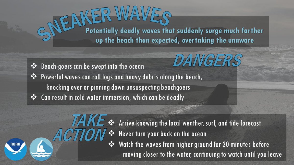
ALT Sneaker waves: Potentially deadly waves that suddenly surge much farther up the beach than expected, overtaking the unaware
Dangers: Beach-goers can be swept into the ocean, powerful waves can roll logs and heavy debris along the beach, knocking over or pinning down unsuspecting beachgoers, can result in cold water immersion, which can be deadly
Take Action: Arrive knowing the local weather, surf, and tide forecast, never turn your back on the ocean, watch the waves from higher ground for 20 minutes before moving closer to the water, continuing to watch until you leave
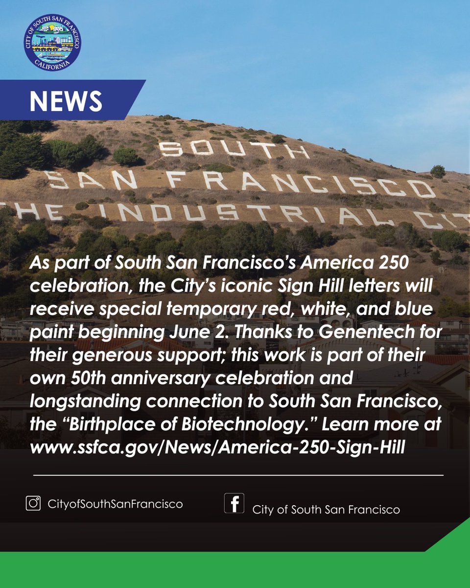
As part of South San Franciscoβs America 250 celebration, the Cityβs iconic Sign Hill letters will receive special temporary red, white, and blue paint beginning June 2. Thanks to Genentech for their generous support; this work is part of their own 50th anniversary celebration and longstanding connection to South San Francisco, the βBirthplace of Biotechnology.β Learn more at ssfca.gov/News/America-250-Sβ¦
π§οΈChances for rain continue for the next couple of days. Scattered showers are possible near interior mountains today before more widespread showers develop tonight through Thursday, particularly across the Central Coast. #CAwx
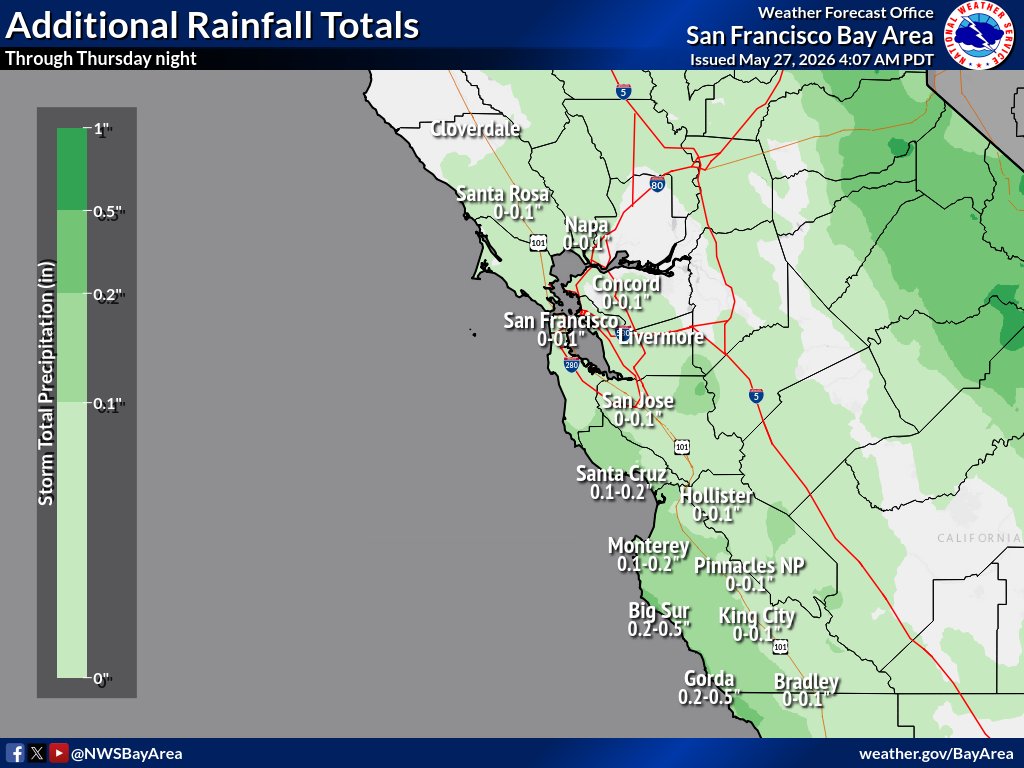
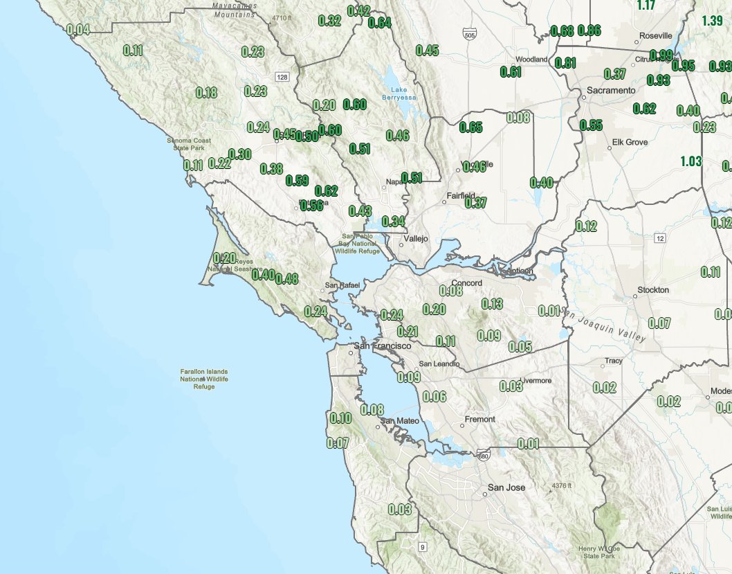
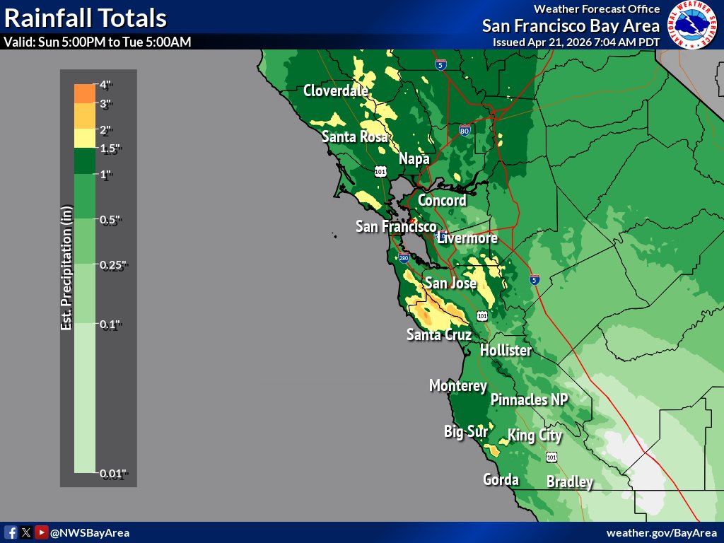
ALT Rainfall totals across the Bay Area and Central Coast through Thursday night. Coastal regions within Santa Cruz and Monterey Counties and the Santa Lucia range will see around a tenth to a quarter of an inch of rain with localized values up to half an inch possible. Elsewhere in the Bay Area and interior Central Coast, less than a tenth of an inch of rain is expected outside of favored mountain areas where higher rain totals are possible.
A Red Flag Warning has been issued for the Valley and Delta area from 5 AM Saturday to 8 PM Monday for the combination of low humidity and gusty winds.
Please review the warning for more details and exercise caution for those with plans over the next several days! #CAwx
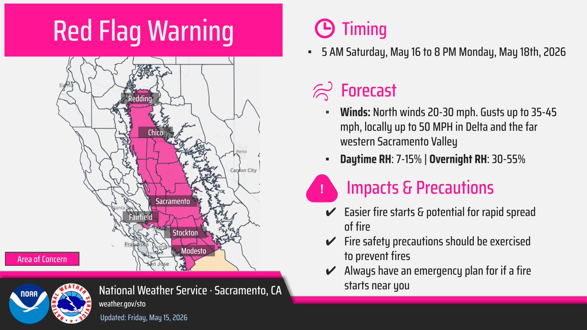
ALT A Red Flag Warning graphic with north winds 20 to 30 MPH with gusts up to 35-45 MPH, locally higher up to 50 MPH in the Delta. Daytime Humidity 7 to 15 %, Overnight Humidity is 30-55%. 5 AM Saturday to 8 PM Monday. Easier fire starts & potential for rapid spread of fire. Fire safety precautions should be exercised to prevent fires. Always have an emergency plan for if a fire starts near you
@Cal_OES is prepositioning firefighting personnel and equipment in advance of forecasted fire weather conditions in Los Angeles and Santa Barbara Counties. Beginning Friday morning and lasting through the weekend, this proactive approach has proven to be a critical component of Californiaβs wildfire response strategy, reducing response times and containing fires before they escalate into major incidents.
For more information follow the link: wp.me/pgM8my-12kw
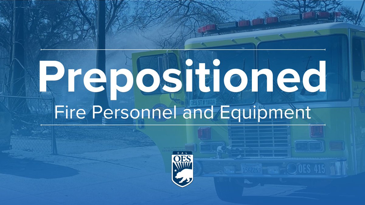
ALT Blue tint with fire truck in the background and the words Prepositioned in front.
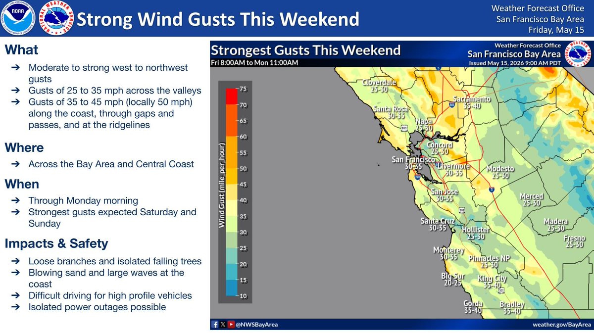
ALT Weather infographic from NWS San Francisco Bay Area titled "Strong Wind Gusts This Weekend," issued May 15, 2026. The text on the left specifies west to northwest gusts of 25-35 mph in valleys and 35-50 mph along the coast and ridges through Monday morning. Impacts include falling branches, blowing sand, difficult driving, and possible power outages. On the right, a color-coded map shows the Bay Area and Central Coast with projected wind gusts. Most inland areas (like Santa Rosa, Concord, and San Jose) are yellow/green, indicating 25-35 mph, while coastal areas and higher elevations (like San Francisco, Santa Cruz, and King City) show orange/yellow shadings for 35-45 mph gusts.
Critical fire weather conditions are expected over the weekend into Monday, with gusty winds & low humidity. Make sure to practice fire safety: Avoid outdoor burning. Avoid using equipment that creates sparks. Make sure no vehicle parts drag . Do not park over dry grass. #CAwx
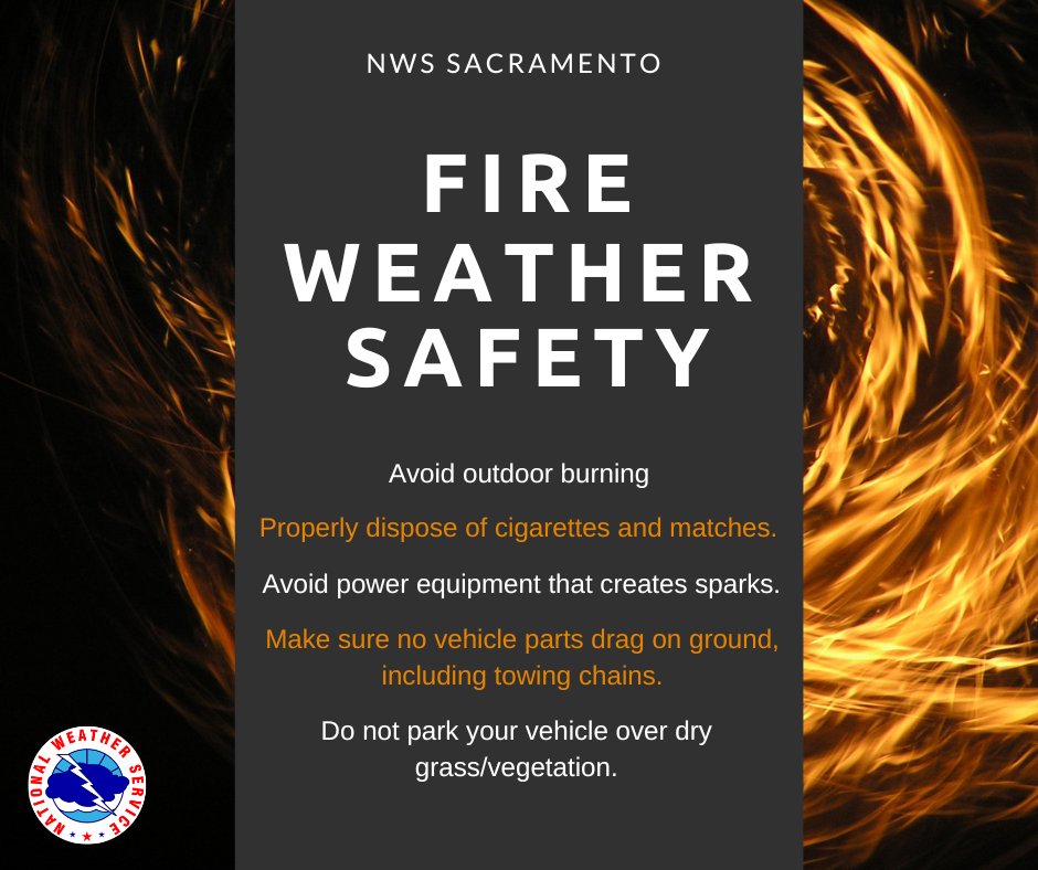
ALT
Fire Weather Safety: Avoid outdoor burning. Properly dispose of cigarettes and matches. Avoid power equipment that creates sparks. Make sure no vehicle parts drag on the ground, including towing chains. Do not park your vehicle over dry grass/vegetation.
Widespread gale force winds across the coastal waters and south SF bay are forecast through the weekend resulting in dangerous marine conditions for mariners and small crafts. If heading out to the coast this weekend, make sure to stay weather and marine aware! π¬οΈπ #CAwx
Today, 5/11, Bay Area air quality is expected to be Moderate in all regions. Tomorrow, 5/12, air quality is expected to be Good in all regions.
See the forecast at: bit.ly/AQforecast.
Radar Update [1:55 PM] - Healdsburg is officially seeing rain! βοΈ Our wx spotters on the ground have confirmed showers moving through. Radar shows the North Bay is currently the target for RA, so keep those wipers on and take it slow on the roads. π§οΈπ #NorthBay#CAwx#Healdsburg
Highs today and for the weekend will be a little on the cool side. Expect a mix of sun and clouds today and Sunday with cloudier skies on Saturday. There's also an increased chance for light rain/drizzle along the Pacific coast this morning and the weekend. #CAwx
π‘Radar Update [4:00am] - Light to moderate rain has begun to fill in out ahead of a boundary that will reach San Francisco ~5am, expect .05"-.15" of rainfall before it moves into the East Bay around 6am. Slow down and be prepared for slick roads and ponding water. #CAwx
Good Morning! βοΈ Who enjoyed the rain? π
Wondering how much rain actually hit your roof over the last 36 hours? βοΈ π
Preliminary totals are in for the Bay Area and Central Coast! See the big winners here:
π partnerservices.nws.noaa.govβ¦#CAwx#BayArea#Rainfall
π‘Radar Update [11:15 AM] - We've had a few showers, but where is the steadier rainfall? It's coming. Here's the latest radar loop showing heavier rain lurking over the coastal waters moving east. #cawx
π‘Radar Update [6:15 AM] - Rain is on the way. Already tipping some buckets over N Sonoma this morning. May need a π§₯and βοΈ for the lunch hour and evening commute. #cawx