
Joined December 2025
- Tweets 545
- Following 116
- Followers 2,186
- Likes 340
155 Photos and videos


Pinned Tweet

30 Dec 2025
🚨NEW ACCOUNT ALERT! The gray zone is going to keep getting brighter. 🔦
If you've tracked our work on @gordianknotray's personal account, you know our mission. Ray hasn't gone anywhere, but we also need our own account.
The SeaLight Foundation is officially launching this dedicated account for a reason: we are ramping up. As a recently accredited 501(c)(3) non-profit organization, we are preparing to expand our offerings of content, data and transparency operations in 2026.
Ray will keep posting his takes, but this handle is where SeaLight's work will live.
*Follow* us here for an "illuminating" 2026!
4
16
53
11,350

Fishermen from Ly Son recently spotted this Chinese navigation buoy at Irving Reef, an atoll claimed by Vietnam, the Philippines & China in the Spratlys. Manila & Beijing have, from time to time, installed buoys to assert control & sovereignty here. Hanoi yet to protest this time

1
25
1,547
SeaLight retweeted

A lengthy “rebuttal” that should be “credited” for its persistent distortion of international law, especially UNCLOS. 🤷🏻♂️

Mr. Powell's remarks are nothing more than the same old script. He attempts to substitute established principles of international law with the flawed notion that "proximity equals sovereignty," while hiding the Philippines' repeated provocations behind a carefully crafted victim narrative.
But no matter how often he repeats these talking points, they cannot change the basic fact that Huangyan Dao is China's inherent territory, nor can they justify the Philippine side's repeated infringements and provocations in the South China Sea in recent years.
A closer look at his argument reveals that it rests on several familiar misconceptions that have long been debunked.
First, under international law, territorial sovereignty is never determined by proximity, but by which state can exercise continuous and effective administration. Huangyan Dao is China’s inherent territory, over which China has continuously, peacefully, and effectively exercised sovereignty and jurisdiction. Prior to 1997, the Philippines never raised any objection to China’s sovereignty over Huangyan Dao. The Chinese side possesses solid evidence in this regard.
Second, as is widely known, UNCLOS does not address questions of territorial sovereignty. Even in the so-called arbitration award repeatedly invoked, is there a single sentence stating that Huangyan Dao belongs to the Philippines?
Third, it is the Philippine side that has continued to stir up trouble and made provocations. On April 10, 2012, the Philippines dispatched the warship BRP Gregorio del Pilar to waters near Huangyan Dao, where it illegally detained Chinese fishermen and fishing vessels operating in the area and subjected them to serious inhumane treatment, deliberately provoking the Huangyan Dao incident. China was compelled to strengthen control measures over Huangyan Dao.
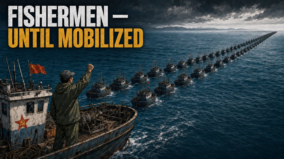
Since the second half of 2023, the Philippines has repeatedly organized coast guard vessels, government ships, and so-called fishing vessels to intrude into China’s territorial sea of Huangyan Dao, forcing China to take further measures in protection of its rights. When Philippine coast guard and government vessels failed to achieve their objectives, the Philippines pushed fishermen to the front line as political tools, to repeatedly charge into sensitive waters.
In 2025, China announced the territorial sea baselines of Huangyan Dao and established a national-level nature reserve there. China’s exercise of jurisdiction over Huangyan Dao and its adjacent waters in accordance with relevant domestic laws fully conforms with international law.
Last but not least, maritime provocations and media grandstanding by certain individuals contribute nothing to the resolution of the dispute and peace and stability in the South China Sea. China will take firm and necessary measures to safeguard its territorial sovereignty and maritime rights and interests.
——Deputy Spokesperson of the Chinese Embassy Guo Wei
8
18
651
🚨BASHI BREAKOUT: On June 7, a 🇨🇳Chinese maritime task force pushed past the Bashi Channel and into the open Pacific.
None were warships. They were coast guard, maritime safety and rescue vessels. The kinds of ships Beijing uses when it wants its presence read as an assertion of lawful jurisdiction over its neighbors' waters.
Hours later, the #CCP-run @globaltimesnews called the operation "a sovereignty declaration with both legal significance and political signaling."
They did not bury the lede. We shouldn't either.
The target was not 🇹🇼#Taiwan alone. It was a maritime delimitation negotiation between 🇯🇵#Japan and the 🇵🇭#Philippines, two 🇺🇸US treaty allies trying to settle their overlapping maritime claims under the 1982 🇺🇳UN Convention on the Law of the Sea, in waters Beijing's own maps don't even claim.
Beijing decided the talks were "completely illegal and void," then ran a multi-agency paramilitary operation to make the point. Coast guard cutters. Provincial Maritime Safety Administration ships. A specialized ocean rescue vessel.
All white-hulled. None of them warships. By design.
Then Beijing had its own state media label the operation a sovereignty declaration, accused the peaceful negotiators of provocation, then cited that label as justification for its own escalation.
This is how China's #grayzone strategy actually works. Not aircraft carriers, not destroyers. A paramilitary force flying civilian colors, advancing a law-enforcement vocabulary, in which patrols like this one first become routine, then become the basis for sovereignty claims the world is expected to accept.
#America's 2026 National Defense Strategy commits to "a strong denial defense along the #FirstIslandChain." The first real test of that doctrine has not come from PLA Navy warships. It has come from white-hulled civilian ships flying a law-enforcement banner, in waters belonging to America's allies.
Allied doctrine needs to grow up.
The First Island Chain has been breached, not by a gray-hulled navy fleet but by white hulls and a vocabulary.
The question now is whether Washington, Tokyo, Taipei and Manila treat this as one more isolated incident to manage, or as the paramilitary challenge to a free and open Indo-Pacific that it actually is.
🔗 Link in the reply below.
4
7
12
428
2/📍 Bashi Breakout — full piece, with maps, sources and the receipts: sealight.live/posts/bashi-br…
1
5
200
📍 Bashi Breakout: full piece, with maps, sources and the receipts:
sealight.live/posts/bashi-br…
19
SeaLight retweeted

@TheStudyofWar’s latest China–Taiwan, co-published with @AEI, uses Starboard’s data to map the PRC’s “law enforcement” surge east of Taiwan — into waters where Japanese and Philippine EEZ claims overlap.
@SeaLightFound independently tracked the same operation on Starboard.
Jun 9

🚨THE BASHI BREAKOUT: 🇨🇳#China has, for the first time, pushed a paramilitary sovereignty assertion past its own "10-dash line" & beyond the First Island Chain to challenge a maritime negotiation it isn't party to.
On May 28, 🇯🇵#Japan & the 🇵🇭#Philippines announced they would delimit their overlapping exclusive economic zones as prescribed by #UNCLOS. Beijing's answer was to send a flotilla through the Bashi Channel & into the open Pacific east of 🇹🇼#Taiwan, into waters that even its own most expansive maps don't (yet) claim.
The key is in which ships Beijing sent: China uses its navy to assert capability--what it can do by force. It uses its coast guard & other government ships as a paramilitary force to assert sovereignty--what it claims.
Not one ship in this flotilla was a warship, because this was a sovereignty claim.
That's what's really new here. For over a decade China used these same gray-zone tactics to assert sovereignty inside its South China Sea "nine-dash line". This week's action pushed somewhere new--going past even the 10th "dash" Beijing added to its 2023 map.
Beyond the First Island Chain.
This assertion was aimed not at Taiwan alone, but at two 🇺🇸US treaty allies. @China_MFA branded the Japan-Philippine talks "completely illegal and void", while a June 1 @globaltimesnews editorial called the idea "an extraordinary and almost unprecedented absurdity… akin to two neighbors sitting in your living room and discussing how to divide your backyard."
Note how China's "backyard" continues to expand. So, in fact, does its "living room".
What SeaLight's tracking shows:
🔹 From 1-5 June, CCG cutters Daishan (2502) & Baita (2304) ran the first clockwise patrol over 200nm east of Taiwan's easternmost island--well past the 10th "dash" on Beijing's 2023 map.
🔹 Late on June 7th, a second wave of 3 provincial Maritime Safety Administration cutters & a rescue tug pushed into the Bashi Channel. The formation entered Taiwan's restricted waters ~30nm off the southern tip, drew a 7-ship Taiwan Coast Guard standoff, then also pushed east.
Beijing's state media left no doubt about what it all meant, first with an official @XHNews/@globaltimesnews announcement, then a June 7 Global Times viewpoint column naming the operation "a sovereignty declaration with both legal significance and political signaling."
Taiwan's NSC chief @josephwutw named it "expansionism in disguise," Defense Minister Koo said it was "cognitive warfare." Both are quite correct.
But the deeper target is Tokyo, Manila & Washington DC, since if Beijing can run a paramilitary sovereignty assertion directly against two US allies' lawful EEZ talks in waters far beyond even its own claim lines, the real message is that China's maritime claims are not just expansive and ambiguous, they are unbounded.
📊 Tracking by @StarboardIntel
1
5
255
Jun 13
🚨PRELUDE TO MORE
SeaLight Executive Director Ray Powell was invited for an interview by the Bilyonaryo News Channel yesterday. Powell told Bilyonaryo that 🇨🇳#China’s recent action of placing a floating structure in Scarborough Shoal represents a tactical shift in how Beijing asserts its expansive claims. According to Powell, this "salami slicing" strategy is designed to set the stage for building more structures in Scarborough and to test the resolve of the 🇵🇭#Philippines and its allies without triggering a military response.
Source: Bilyonaryo News Channel
6
35
84
2,166
SeaLight retweeted

Jun 13
SURPRISE: 🇨🇳@Chinaembmanila is calling its new platform at #ScarboroughShoal a "scientific expedition" & accusing the 🇵🇭#Philippines of "stirring up trouble" for bringing it up.
Wait ... let me show you my "shocked" face: 😲
Scarborough sits about 125 nm from Luzon, roughly 4 times closer to the Philippines than to #China. It's inside the Philippine exclusive economic zone, where Filipino fishermen worked its waters for generations until China seized the shoal in 2012 & began restricting access.
But now the embassy reminds us again about China's "indisputable" & "inherent" right to whatever it claims. Golly, where have we heard that before? 🙄
(Bizarrely, Beijing also describes this as a "dispute" that should be resolved diplomatically--one of those two lines of argument is doing an awful lot of work.) 🤔
Over the past two years, Beijing has doubled its coast guard & militia presence at the shoal, and it now enforces an undeclared & illegal 30 nm exclusion zone that violates UNCLOS' freedom-of-navigation clauses (and thus the 2002 Declaration on the Conduct of Parties in the #SouthChinaSea, which Beijing signed) & keeps Philippine vessels out.
Most marine scientists don’t arrive with a large paramilitary cordon and a stack of talking points.
If this is an environmental survey, at least we can understand why it's necessary. The damage done by over a decade of destructive PRC giant clam harvesting at Scarborough is depressingly well documented -- except by Beijing, which publishes glossy tributes to its environmental stewardship while denying access to anyone who might want to check its work.
🔥 What we have here is a classic case of gray-zone gaslighting: seize your neighbor’s fishing ground, blockade it -- oh, and while you're at it cause a high‑speed collision between two of your own ships while chasing a much smaller Philippine patrol boat operating in waters it used to sail freely -- and then scold your neighbor for being "provocative" when it has the temerity to point out what you’ve done.
We all know this isn’t really about science. Sorry, but China has, by its actions, forfeited the benefit of the doubt.
It's about expansionism. Full stop. 🛑
Wrapping a maritime occupation in the language of "science" and "conservation" doesn’t make it any less of an occupation.
It does make for cute AI-generated social media rebuttals to @jaytaryela. So well done on that.
1. Huangyan Dao is China's inherent territory, and China has indisputable sovereignty over Huangyan Dao and its adjacent waters. China's activities, including scientific research, in the relevant waters are normal actions within the scope of its sovereignty, which are beyond reproach.
2. In recent years, the Philippine side has continuously stirred up trouble and provoked China in and around Huangyan Dao under the pretext of "transparency." The Philippine military and coast guard have even clamored for "retaking" Huangyan Dao, which is the very root cause of the escalation of tensions at sea.
3. The so-called "transparency" initiative is nothing but a pretext Mr. Tarriela uses to cherry-pick facts, manipulate public opinion and attack and smear China. China has repeatedly pointed out that if "transparency" is what Mr. Tarriela truly wants, then every time he goes on an attack, post the full facts that China has laid out right alongside it. But Mr. Tarriela plays deaf and dumb on that, never daring to respond, because presenting the full picture would instantly expose its fake "transparency" ploy.
4. China's position on addressing the maritime disputes with the Philippine side is consistent and clear. China remains committed to settling differences and managing the situation at sea through dialogue and consultation, and rejecting the amplification of differences through megaphone diplomacy.
——Deputy Spokesperson of the Chinese Embassy Guo Wei

15
141
258
8,610
SeaLight retweeted
Jun 12
🚨The Chinese Embassy’s Midnight Hate Attack
Filipina journalist Regine Cabato recalled her experience when the Chinese Embassy attacked a social media post made by the Philippine Center for Investigative Journalism (PCIJ), labeling it “Pro-China Propaganda.”
Strangely enough, Regine observed that some Filipino partisan bloggers bandwagon on the hate train with PCIJ parroting China-aligned narratives.
If you want to learn more about this interview - click here to watch the full interview: youtu.be/s3zVOo8J0XY
1
29
82
2,633
SeaLight retweeted

In the latest episode of “Why Should We Care About the Indo-Pacific?,” Ray Powell, Jim Carouso and Lisa Curtis talk about why the United States, Japan and the Philippines are emerging as the backbone of deterrence in the Western Pacific.
youtu.be/ufWkRGXXO1Y?si=47hr…
2
2
5
653
SeaLight retweeted

Jun 11
The Silent Mapping of Sarawak: China’s Grey-Zone Fleet Tightens Its Grip
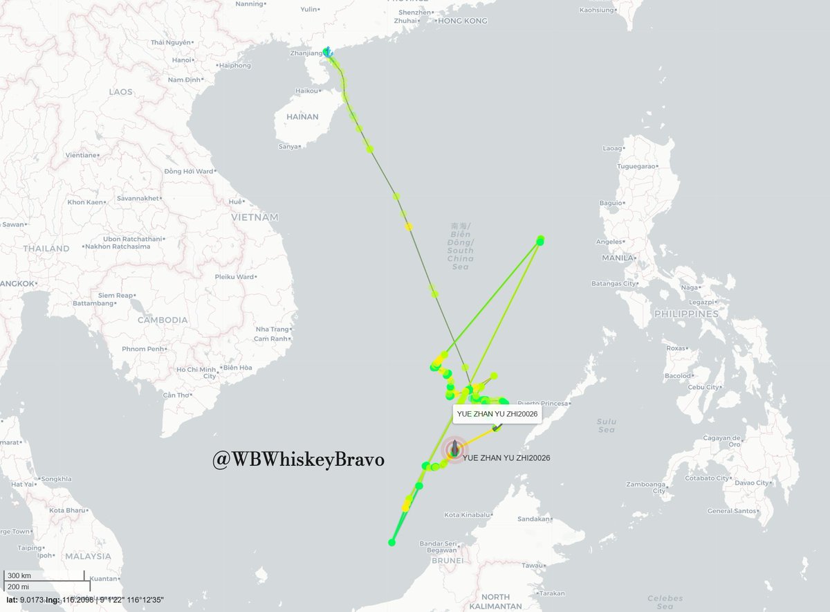
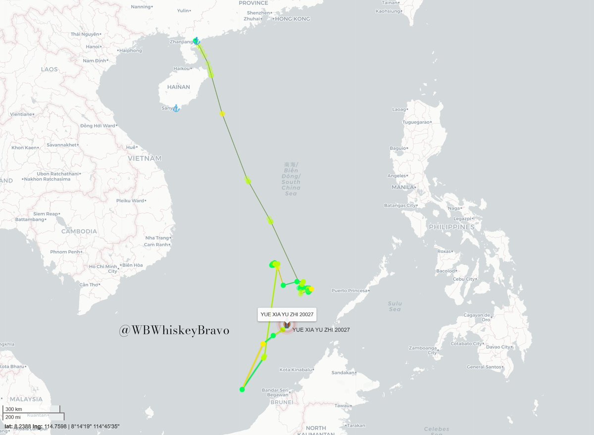
Right now, a quiet but deeply troubling shift is happening just off the coast of Sarawak. Tracking data up to June 10, 2026, reveals that China Coast Guard (CCG) vessels are practically making themselves at home inside the Malaysian Maritime Zone (MMZ). If you look at the paths taken by CCG 5302 and CCG 5403, these ships sailed straight down from Hainan and immediately settled into slow, overlapping patrol loops around South Luconia Shoals (Gugusan Beting Patinggi Ali) and North Luconia Shoals (Gugusan Beting Raja Jarum). They aren't just passing through on a normal transit; they are loitering at speeds as slow as 1 to 8 knots. This places them right in the backyard of Malaysia's vital offshore oil and gas fields, hanging over local operations like a permanent shadow. Meanwhile, CCG 5309 is tightly patrolling around Ardasier Bank (Permatang Ubi), and the massive 12,000-ton "Monster Ship" (CCG 5901) is holding its ground near Vanguard Bank, keeping intense pressure on the western edges of the eastern MMZ.
What makes this situation truly alarming is how seamlessly China is pairing these coast guard escorts with specialized research and survey vessels. The data shows that the advanced research ship XIANG YANG HONG 33 traveled all the way down from Guangdong, working its way through the West Philippine Sea before pushing deep into the waters off Sarawak. Alongside it, support vessels like YUE ZHAN YU ZHI 20026 and YUE XIA YU ZHI 20027 are believed to have been busy conducting surveys, marine research or water sampling around Gugusan Semarang Peninjau (GSP). Under international maritime law (UNCLOS), no foreign country is allowed to map the seabed or conduct marine research inside another nation's EEZ without explicit permission. By completely ignoring this rule, these ships are freely mapping the ocean floor, collecting sonar data, and tracing underwater topography. It is an unauthorized intelligence-gathering operation happening right under Malaysia's nose.
This isn't a random, one-off scientific expedition either; it is a highly coordinated, rotating pattern. Before heading over to Terumbu Peninjau (Investigator Shoal), this exact same trio—XIANG YANG HONG 33, YUE ZHAN YU ZHI 20026, and YUE XIA YU ZHI 20027—spent a significant amount of time mapping the complex underwater environment around Luconia Shoals. This entire fleet, acting under the close protection of the CCG, originally targeted the reefs of the West Philippine Sea before moving smoothly southward into East Malaysia’s waters. By floating seamlessly across these maritime borders, Beijing is essentially treating the shared waters of Southeast Asian nations as one giant, continuous research laboratory, methodically mapping the region’s continental shelf block by block.
If there was ever any doubt about how closely these ships work together, satellite imagery from June 6, 2026, strips it all away. Captured at Terumbu Laya (Dallas Reef), the image provides undeniable "ground truth" proof of a physical gathering at sea. You can clearly see the survey vessels YUE ZHAN YU ZHI 20026 and YUE XIA YU ZHI 20027 bunched tight against the research ship XIANG YANG HONG 33 right along the edge of the reef, while CCG 5309 sits perfectly positioned nearby to act as an armed shield. This snapshot proves these aren't independent civilian science boats that accidentally drifted off course. They are operating as a single, unified unit, using the muscle of the China Coast Guard to lock down the area and secure their illegal mapping operations.
This situation puts a spotlight on the massive contrast in how regional neighbors handle these "grey-zone" tactics. Manila has adopted a policy of "assertive transparency"—they openly confront CCG ships, embed journalists on patrol vessels, and fire off immediate diplomatic protests the second a Chinese research ship slips into their EEZ. Kuala Lumpur, on the other hand, has stuck to its traditional "quiet diplomacy," preferring behind-the-scenes talks and avoiding any public call-outs or friction on the water. But this difference in pushback has created a lopsided reality: while Chinese fleets face intense public exposure and friction in Philippine waters, they find a path of much less resistance in the MMZ, allowing them to map Malaysia's seabed with almost zero operational risk.
Ultimately, this ongoing silence from the federal government is a gamble with Malaysia's maritime future. In diplomacy, staying quiet for too long can easily be misread as "tacit acquiescence"—a silent thumbs-up. Because Beijing is facing zero public pushback or official diplomatic friction from Putrajaya, it slowly normalizes their presence. Without any real opposition, China will only grow bolder. It is a slippery slope that could eventually lead to Chinese assets openly interfering with PETRONAS or foreign drilling company operations, aggressively pushing back local Royal Malaysian Navy (RMN) or Maritime Enforcement Agency (MMEA) patrols, or harassing local fishermen trying to make a living.
To make matters worse, there seems to be a serious disconnect between the federal government and the state of Sarawak. Because national security and foreign policy are strictly handled in Putrajaya, the true scale, intensity, and sheer frequency of these daily incursions are likely not being fully shared with Sarawak's leadership. It leaves the local government largely in the dark about a massive grey-zone threat operating right on their doorstep. This is a critical blind spot, especially when you consider that if things ever escalate out at sea, it is Sarawak’s offshore energy lifelines and maritime sovereignty that are directly on the line.

ALT The images above display the tracking data of Chinese survey vessels encroaching into Malaysian waters off East Malaysia

5
49
95
55,863
SeaLight retweeted
Jun 11
The Silent Takeover: How China is Quietly Rewriting the Borders Off Sarawak’s Coast
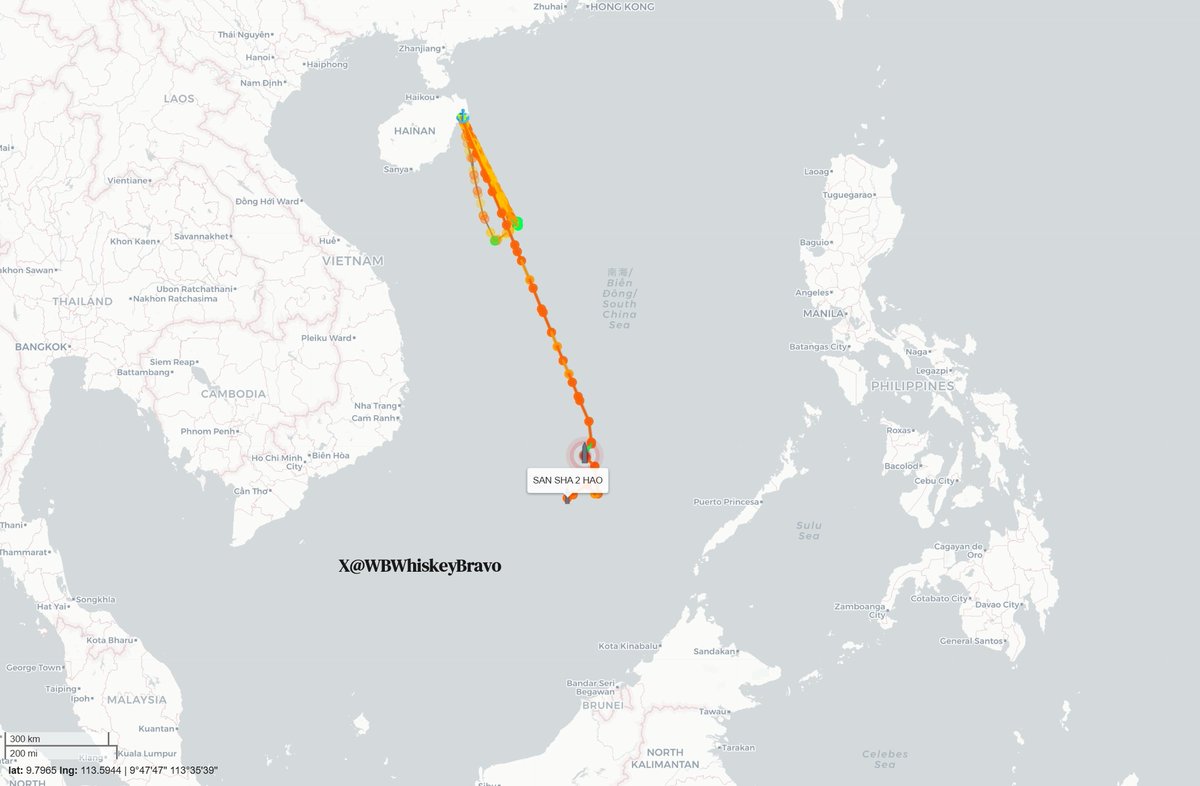
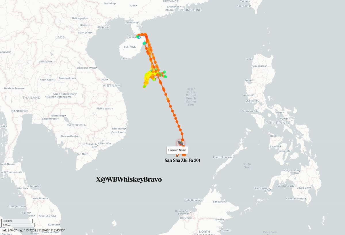
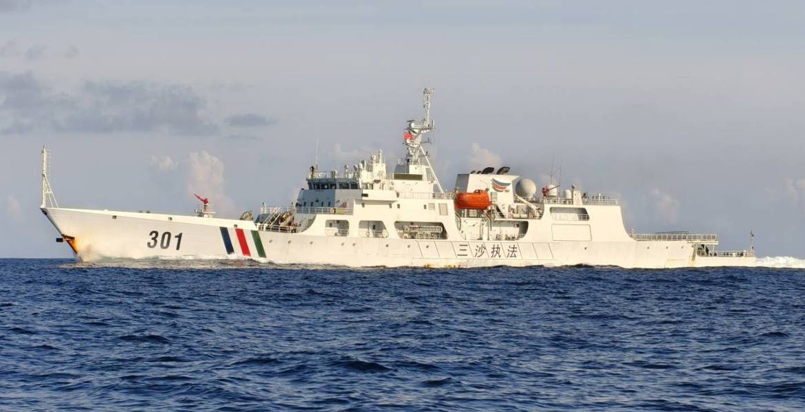
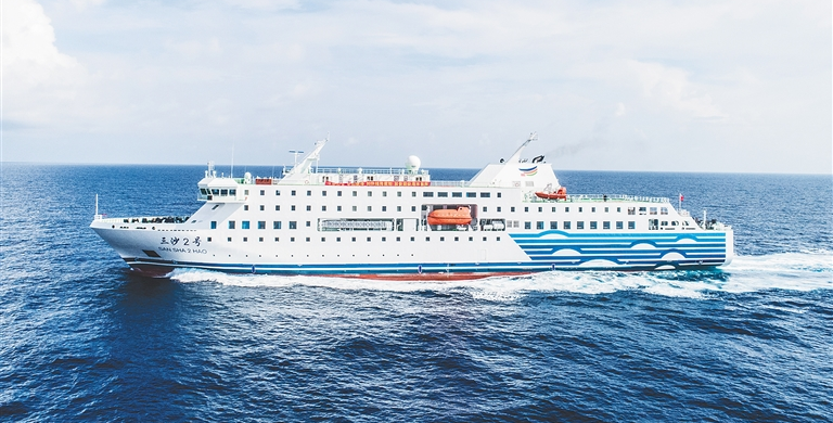
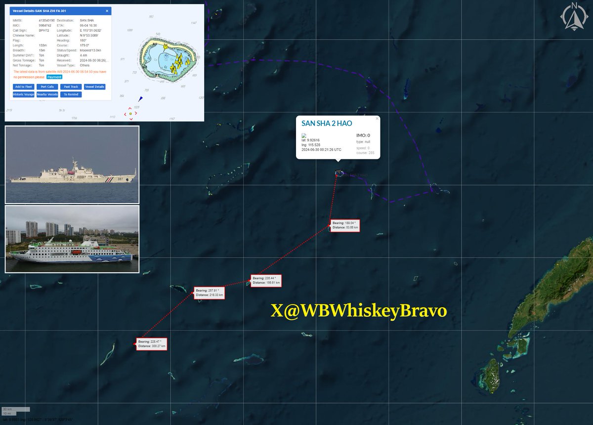
While most of us go about our daily lives, a quiet but deeply troubling game of chess is playing out just off the coast of Sarawak, where fresh ship-tracking data reveals that China’s massive 8,000-ton supply ship, the Sansha 2 Hao, along with its armed escort cutter, the San Sha Zhi Fa 301, has packed up and left Hainan. This fleet is steaming directly south toward Beting Serupai (James Shoal / Seahorse Breakers), a completely submerged reef sitting just 45 nautical miles—about 80 kilometers—northwest of Bintulu, placing it squarely in Sarawak’s backyard. This voyage fits perfectly into Beijing's broader grey-zone tactics, which are designed to aggressively change realities on the water while staying just below the threshold of open military conflict. To enforce its sweeping nine-dash line without triggering an international military outcry, China masterfully relies on "white hull"—coast guard and municipal vessels—instead of navy warships, allowing them to bully local maritime zones under the guise of routine domestic and administrative patrols.
The reason Chinese delegates and municipal fleets execute this voyage on a strict, annual basis comes down to a calculated symbolic ritual designed to manufacture legal and historical "evidence" of ownership. Because Beijing historically and geographically defines Beting Serupai (Zengmu Ansha) as the absolute southernmost point of Chinese national territory, it holds massive nationalistic and political significance. Since the feature is completely submerged about 22 meters underwater, China cannot build an artificial military island on it; instead, they send annual delegations on these white hulls to conduct "sovereignty ceremonies" above the reef. In past rituals, Chinese naval personnel and officials have literally dropped sovereignty steles (stone markers) into the water and stood on the decks to swear collective oaths of allegiance to defend the motherland's outer limits. By sending the Sansha city fleet down every single year, Beijing is attempting to satisfy the international legal criteria of "continuous and effective administration." They are intentionally creating an annual paper trail that falsely claims a local Chinese city has been successfully governing a piece of the seabed just 80 kilometers from Bintulu.
This annual municipal voyage is just the crowning piece of a massive, multi-tiered machinery that builds upon the homework done by older research ships like the Nan Feng and Zhong Shan Da Xue, which originally gathered resource intelligence in the Malaysian Maritime Zone (MMZ). Today, that legacy is carried forward by modern high-tech spies like the XIANG YANG HONG 33, YUE ZHAN YU ZHI 20026, and 20027, which were caught on satellite imagery on June 6 tightly bunched together at Terumbu Laya (Dallas Reef), updating underwater maps under the protective shield of armed white hulls like CCG 5302, 5403, 5309, and 5901. By dropping the Sansha municipal fleet directly alongside this ongoing scientific and military grid, Beijing is essentially using the annual trip to lock down East Malaysia’s richest economic zones, posing a direct threat to Sarawak’s multi-billion dollar offshore oil and gas fields. Yet, while neighbors like the Philippines push back through "assertive transparency" by openly exposing these incursions, Putrajaya has stuck to its strict playbook of "quiet diplomacy," preferring behind-the-scenes talks to avoid public friction. This heavy silence risks being misread by Beijing as "tacit acquiescence," giving them a path of least resistance to slowly turn a fictional map into a permanent reality. Furthermore, because national security is tightly controlled by the federal government, this quiet approach leaves the local Sarawak state leadership dangerously in the dark about a creeping grey-zone threat operating just a stone's throw away from its vital economic lifelines and maritime sovereignty.
30 Jun 2024

Just another year. The PRC conducts an annual event in which high-ranking CCP delegates travel to the southernmost part of their claim. The participant transport was the luxurious passenger ship SAN SHA 2 HUO, escorted by SAN SHA ZHI FA 301, which had just departed Mischief Reef.
8
53
104
18,207
Jun 11
🚨 What is the Philippines Enhanced Resilience Act? (PERA)
Despite a general pullback on foreign aid, the Philippine Enhanced Resilience Act secures $2.5B in US military grants through 2030.
Retired U.S. Ambassador to the Philippines
@MaryKayCarlson joins SeaLight Executive Director Ray Powell (@GordianKnotRay) and @IndoPacPodcast
Co-host Jim Carouso to discuss U.S.-Philippines relations. In this clip, Amb. Carlson explains the PERA act and what drives this robust bipartisan support from the U.S. Congress to the Philippines
1
14
57
1,916
SeaLight retweeted
Jun 11
Sorry but no. There has been nothing like a truce at Scarborough Shoal these last 2 years sealight.live/posts/china-s-…
3
8
44
1,357
SeaLight retweeted

Jun 10
For the first time ever, China has effectively made a sovereignty claim to a portion of the Pacific Ocean.
Jun 9
🚨THE BASHI BREAKOUT: 🇨🇳#China has, for the first time, pushed a paramilitary sovereignty assertion past its own "10-dash line" & beyond the First Island Chain to challenge a maritime negotiation it isn't party to.
On May 28, 🇯🇵#Japan & the 🇵🇭#Philippines announced they would delimit their overlapping exclusive economic zones as prescribed by #UNCLOS. Beijing's answer was to send a flotilla through the Bashi Channel & into the open Pacific east of 🇹🇼#Taiwan, into waters that even its own most expansive maps don't (yet) claim.
The key is in which ships Beijing sent: China uses its navy to assert capability--what it can do by force. It uses its coast guard & other government ships as a paramilitary force to assert sovereignty--what it claims.
Not one ship in this flotilla was a warship, because this was a sovereignty claim.
That's what's really new here. For over a decade China used these same gray-zone tactics to assert sovereignty inside its South China Sea "nine-dash line". This week's action pushed somewhere new--going past even the 10th "dash" Beijing added to its 2023 map.
Beyond the First Island Chain.
This assertion was aimed not at Taiwan alone, but at two 🇺🇸US treaty allies. @China_MFA branded the Japan-Philippine talks "completely illegal and void", while a June 1 @globaltimesnews editorial called the idea "an extraordinary and almost unprecedented absurdity… akin to two neighbors sitting in your living room and discussing how to divide your backyard."
Note how China's "backyard" continues to expand. So, in fact, does its "living room".
What SeaLight's tracking shows:
🔹 From 1-5 June, CCG cutters Daishan (2502) & Baita (2304) ran the first clockwise patrol over 200nm east of Taiwan's easternmost island--well past the 10th "dash" on Beijing's 2023 map.
🔹 Late on June 7th, a second wave of 3 provincial Maritime Safety Administration cutters & a rescue tug pushed into the Bashi Channel. The formation entered Taiwan's restricted waters ~30nm off the southern tip, drew a 7-ship Taiwan Coast Guard standoff, then also pushed east.
Beijing's state media left no doubt about what it all meant, first with an official @XHNews/@globaltimesnews announcement, then a June 7 Global Times viewpoint column naming the operation "a sovereignty declaration with both legal significance and political signaling."
Taiwan's NSC chief @josephwutw named it "expansionism in disguise," Defense Minister Koo said it was "cognitive warfare." Both are quite correct.
But the deeper target is Tokyo, Manila & Washington DC, since if Beijing can run a paramilitary sovereignty assertion directly against two US allies' lawful EEZ talks in waters far beyond even its own claim lines, the real message is that China's maritime claims are not just expansive and ambiguous, they are unbounded.
📊 Tracking by @StarboardIntel
22
41
135
16,914
SeaLight retweeted

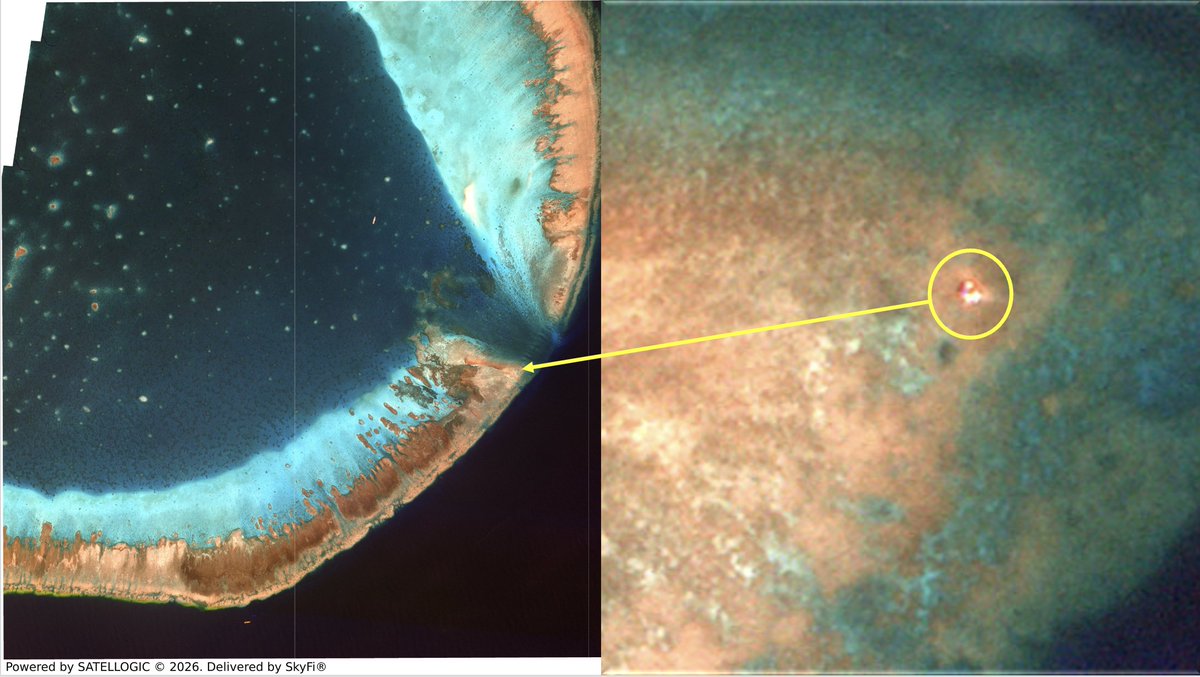
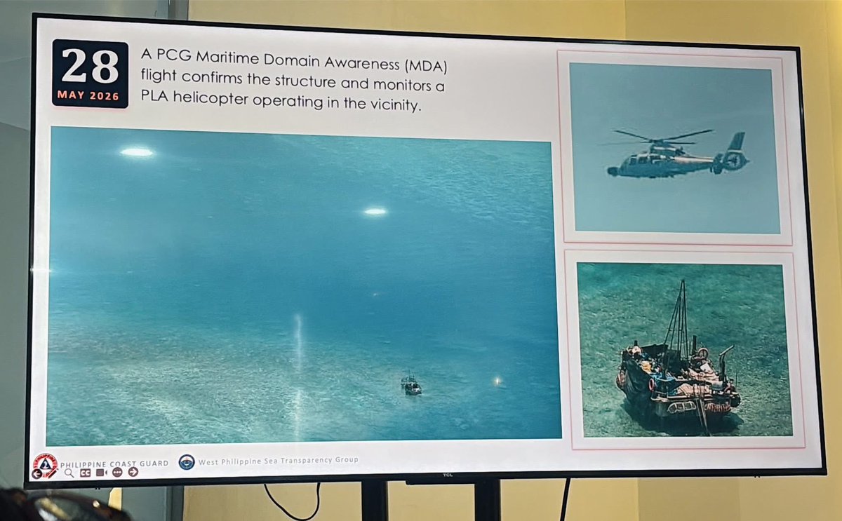
Jun 10
🚨CHINA’S NEW MOVE IN THE WEST PHILIPPINES SEA IS RAISING ALARMS | The presence of Chinese nationals on a floating platform inside Bajo de Masinloc, coupled with the coordinated deployment of PLA Navy warships, China Coast Guard vessels, maritime militia units, and rotary-wing aviation assets, reflects a calculated campaign to entrench China’s influence and establish a persistent footprint within Philippine waters.
These actions are indicative of an ongoing gray-zone operation aimed at transforming temporary presence into perceived control, undermining Philippine sovereignty while advancing China’s strategic objective of consolidating dominance in the West Philippine Sea.
📢 The World is Watching. Share and Expose the deception. Defend the truth.
#BRPSierraMadre #WestPhilippineSea #ScarboroughShoal #BajoDeMasinloc #DefendTheTruth #KnowTheFacts #RulesBasedOrder #ProtectWhatIsOurs #MaritimeRights #FactsOverPropaganda


8
96
158
3,175
SeaLight retweeted

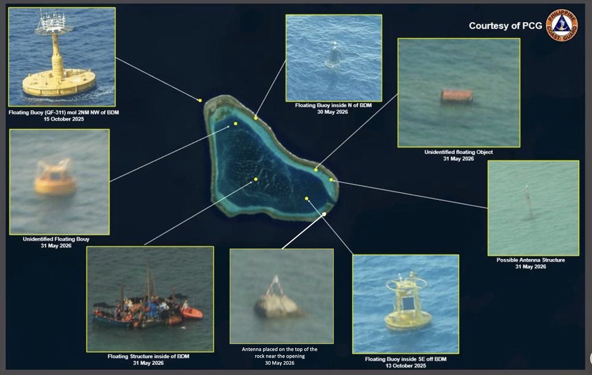
Jun 10
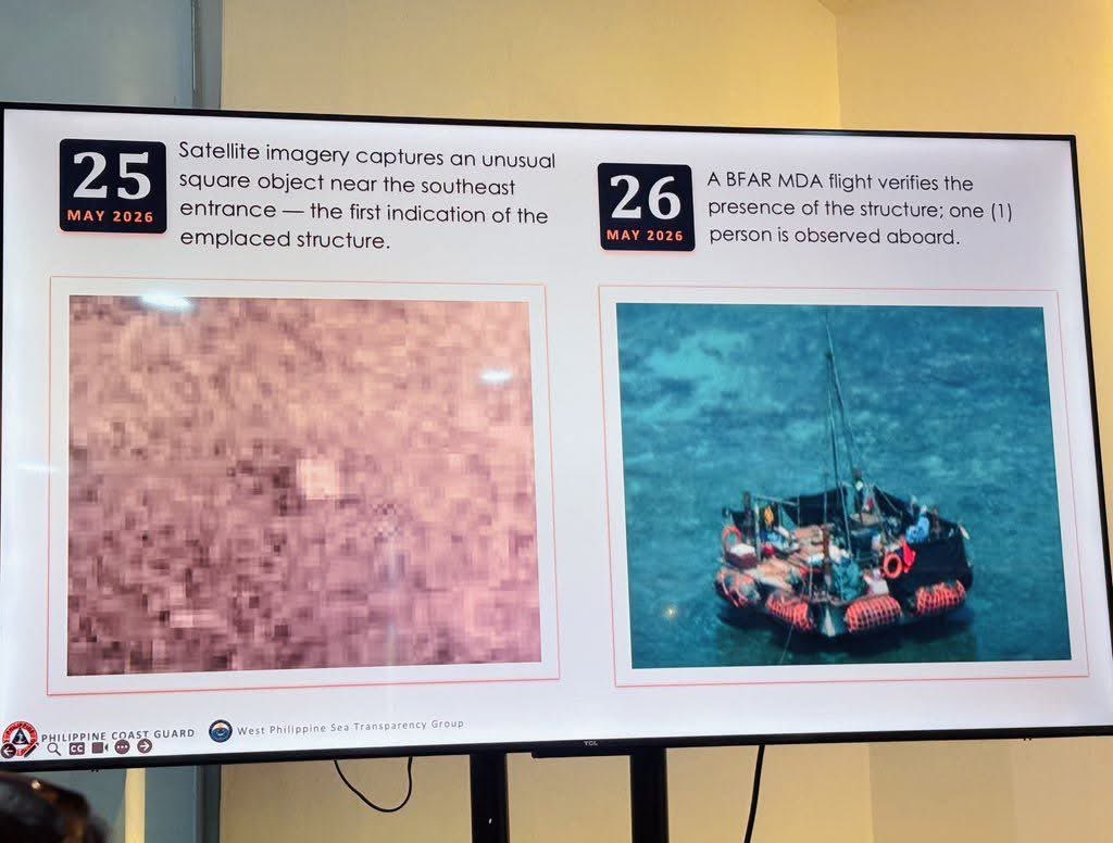
To date, the Philippine government have documented the PRC’s movable floating platform, three newly installed floating buoys on top of the two dropped last October, an unidentified floating spherical object, and two antennas — all unlawfully placed.
85
264
1,177
593,572