
Leading the largest CTO operation - BILLISH 💎 Founder of @respawnring & $DOUGH 🇺🇸
Joined July 2022
- Tweets 41,595
- Following 421
- Followers 3,203
- Likes 43,644
5,956 Photos and videos


Pinned Tweet

Jun 2
5.6m bled through 2 collections.
Only 1 person stood in the way.

6
8
18
499
ShilliBilli retweeted

Jun 12
Elon Musk became the first trillionaire today. Someone do a wellness check on Bernie Sanders.
1,269
565
11,461
161,558
ShilliBilli retweeted

Just swept a @BunniesNHomies and @degensx from @respawnring for a $Dough bounty! All staked for more! Thanks to @ShilliBilli!


17
18
20
146
Jun 12
Congrats! @elonmusk 🎉
Jun 12

Elon Musk officially becomes the first TRILLIONAIRE in human history.


1
21
Jun 12
Would you pfp?
• Share ♻️
• Like 👍
• Tag your gang 🤝
GO 🏁 🐰 🧹

1
3
8
125
ShilliBilli retweeted

Jun 11
Ominous green sky.
Maxwell filmed this dark storm structure in Kenosha, Wisconsin, a few moments ago right before a tornado came through.
66
390
3,233
128,527
Jun 11
EVERYONE FILL UP YOUR GAS TANKS NOW! - W IRAN SHUTTING DOWN THE STRAIT ONCE AGAIN WE WILL SEE AN EASY $1.00 / $1.35 INCREASE IN UNLEADED ⛽️
WE JUST BROKE UNDER $4 (average $3.90 / maxed out at $4.65 in WISCONSIN)
BUY THE BARRELS NOOOWWW
77
Jun 11
Be safe out there Midwest!
Jun 10

Here is a 6 hour loop of the likely Derecho we just had through the Midwest impacting Madison, Wisconsin and Chicago, now moving through Michigan. Check out all the reports of wind damage and measurements that have come in so far!
Round 2 is brewing in Eastern Iowa and will make its way across some of the same areas that were impacted just hours before.
More rounds of significant storms are also expected in the same area tomorrow...
57
Jun 10
Dis bihgah

Someone on Reddit built a game where you ride a dirt bike on top of any company's stock chart.
1
2
118
ShilliBilli retweeted

Jun 9
417
1,206
14,800
548,034
ShilliBilli retweeted

Jun 10
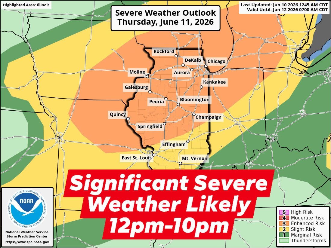
Thursday will be a classic destructive wind and qlcs tornado fest across northern Illinois. Also concerning about prefrontal supercells capable of tornadoes across far northern Illinois and southern Wisconsin near/south of the warm front. The environment will be primed for all hazards from midday and on. #ilwx
Jun 10

**An even more concerning severe weather outbreak is on the table for Thursday across northern Illinois**
- Thursday looks like the real deal for northern Illinois as models last night and this morning show a rather volatile environment tomorrow late morning and afternoon. Storms will likely be ongoing tomorrow morning across Iowa and these will progress east towards northern Illinois by midday. Thursday afternoon will be the start of the severe weather threats as storms evolve across northwest Illinois. All hazards will be on the table including destructive wind gusts greater than 75 mph, destructive hail potential larger than golf balls, and tornadoes, cant rule out a strong tornado. There could be a couple waves of severe weather tomorrow afternoon and evening but an organized squall line will be the main event which will move through late afternoon and evening.
- The ceiling for destructive winds and at least embedded qlcs tornadoes tomorrow are rather elevated. A tornado outbreak could occur as well across southern Wisconsin and potentially northern Illinois near the warm front. An upgrade to a moderate risk is likely in the near future for northern Illinois into southern Wisconsin.
- It will surely be a day to monitor the radar and be prepared to seek shelter indoors when storms arrive. Travel plans in and out of Chicago from 4pm-9pm will be heavily effected by storms. #ilwx
4
10
98
19,774
ShilliBilli retweeted

Jun 9
Stay tuned for the going public announcement... 🟣
Jun 9

Status update: Orbis is up, running, and ready.
Just saying. 🟣
Relist On Orbis today..

18
31
98
3,451
ShilliBilli retweeted
Jun 9
Status update: Orbis is up, running, and ready.
Just saying. 🟣
Relist On Orbis today..
38
60
144
8,836