
NOAA's Cooperative Institute for Meteorological Satellite Studies (since 1980) at the University of Wisconsin-Madison, the birthplace of satellite meteorology.
Joined July 2014
- Tweets 13,088
- Following 317
- Followers 27,977
- Likes 36,722
8,547 Photos and videos


Jun 12
1-minute Mesoscale Sector @NOAASatellites #GOESEast (#GOES19) Vis (top) and IR images with time-matched plots of SPC Storm Reports showed a supercell thunderstorm Thursday 6/11 that produced a possible long-track tornado ( winds and hail) across northeast #ILwx. @NWSChicago
1
5
719
Jun 7
1-min @NOAASatellites #GOES19 Vis & IR imagery with GLM Flash Points show a supercell thunderstorm that developed in far eastern Saskatchewan and moved across southern Manitoba Saturday producing large hail & heavy rain & prompted the issuance of a tornado warning. #mbstorm #mbwx
3
8
1,846
Jun 4
The @NOAASatellites SUVI on GOES-18 and GOES-19 detected solar flares that produced Coronal Mass Ejections, which prompted the issuance of a G3 Geomagnetic Storm Watch. More on the CIMSS Satellite Blog: cimss.ssec.wisc.edu/satellit…
2
7
684
Jun 1
The @NOAASatellites #GOES19 #GLM instrument detected a bolide over eastern Massachusetts on Saturday 5/30/2026. More on the CIMSS Satellite Blog: cimss.ssec.wisc.edu/satellit…
1
11
22
1,851
May 25
The launch of SpaceX Starship Test Flight 12 (on 22 May), True Color RGB images from @NOAASatellites
#GOES16 and #GOES19 showed the rocket booster's condensation cloud as it drifted eastward away from the Starbase launch site on the S. Texas coast. More: cimss.ssec.wisc.edu/satellit…
3
10
1,117
May 19
With @NOAASatellites #GOES16 briefly out of storage for testing, here is a 3-GOES Water Vapor imagery depiction of a "leeside cold frontal gravity wave" as it propagated southward across the central and southern Plains today (19 May 2026)...
5
13
975
May 18
1-minute @NOAASatellites #GOES19 Sandwich Product imagery from yesterday evening (5/17/2026) showing multiple tornado warnings, mostly across Nebraska. #NEWX @NWSOmaha
4
11
924
May 18
1-minute Vis and Shortwave Infrared images from @NOAASatellites #GOESEast (#GOES19) showed a fast-moving grass fire that prompted the issuance of an Evacuation Immediate order 5/17/2026 for residents near Campo in far SE Colorado. More: cimss.ssec.wisc.edu/satellit… #COwx @NWSPueblo
5
14
1,469
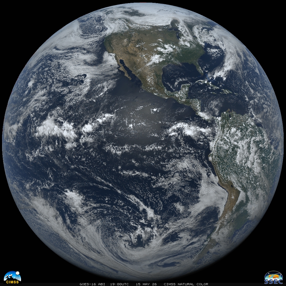
May 15
Here's @NOAASatellites #GOES16 today at local satellite noon (19:00UTC) with the CIMSS Natural Color enhancement. GOES-16 is out of storage for testing for about 2 weeks. Happy #FullDiskFriday!
2
5
23
2,337
May 7
30-second Infrared imagery from @NOAASatellites #GOESEast (#GOES19) with time-matched plots of SPC Storm Reports showed an outbreak of tornadoes across southern Mississippi, in addition to large hail and damaging winds across parts of Mississippi and Alabama yesterday (May 6).
10
12
862
Apr 29
1-minute Mesoscale Domain Sector @NOAASatellites #GOESWest (GOES-18) GeoColor RGB images with/without an overlay of NGFS Fire Detection polygons showed the thermal signature, smoke plume and dark burn scar of the wind-driven #SparksFire in Quay County, New Mexico. @NWSAlbuquerque
5
19
1,458
Apr 29
Overlapping 1-min Mesoscale Domain Sectors provided images at 30-sec intervals on 27 April; #GOESEast Visible imagery with time-matched plots of SPC Storm Reports showed hail as large as 4.00" in diameter & a wind gust to 60 mph southwest of @NWSStLouis.
1
3
25
1,791
Apr 27
1-min GOES-19 Infrared images w/ time-matched plots of SPC Storm Reports showed severe thunderstorms that produced hail as large as 4.00" in diameter in southern Kansas & the EF4-rated tornado (& 107 mph wind gust) near #Enid, Oklahoma on 23 April. More: cimss.ssec.wisc.edu/satellit…
7
31
2,528
Apr 23
Here's our local noon composite for #EarthDay made from 5 geostationary imagers (2 USA, 2 EUMETSAT, 1 JMA). Where were you at noon? Unless you were off planet or in the arctic/antarctic circle, you must be in this image somewhere! About local noon images: ssec.wisc.edu/data/composite…
1
3
13
917
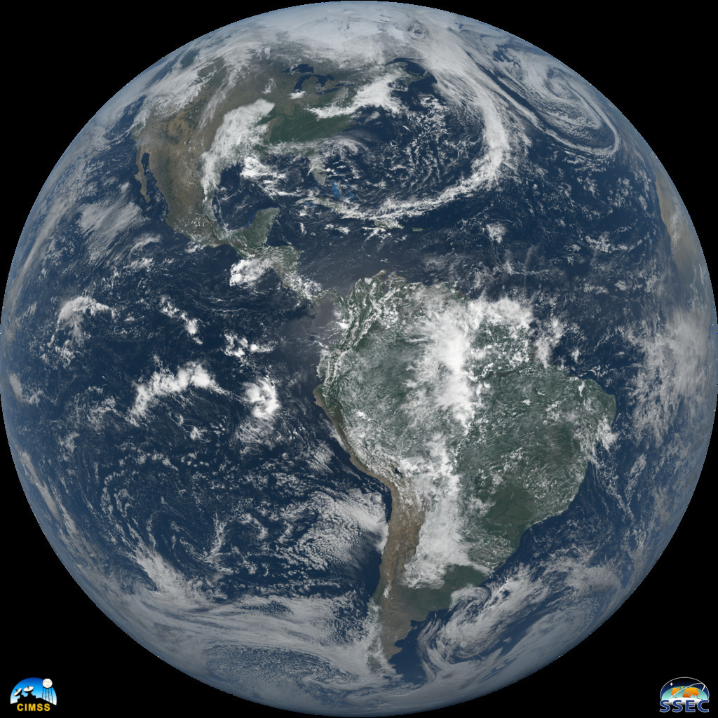
Apr 22
Now that the sun has set on the @NOAASatellites #GOESEast subpoint, here is an animation from sunrise to sunset for #EarthDay with the "CIMSS Natural Color" enhancement:
10
18
1,502
Apr 22
We did not forget that today is #EarthDay! Here is @NOAASatellites #GOES19 Full Disk at local satellite noon. More images and animations will be added to this CIMSS Satellite Blog post: cimss.ssec.wisc.edu/satellit…
3
10
1,009
Apr 21
From @NWSSPC: A small cluster of elevated tstorms has persisted into early afternoon in SE WI, aided by forcing for ascent attendant to an upstream shortwave trough. This animation shows what we saw from @NOAASatellites #GOESEast and our rooftop cameras as it appeared overhead.
2
5
18
1,121
Apr 21
The @NWSSPC mesoscale discussion: spc.noaa.gov/products/md/md0…
and our realtime GOES-East imagery combined with our rooftop cameras website: cimss.ssec.wisc.edu/goes/rtc…
and @NWSMilwaukee issued thunderstorm and special marine warnings this afternoon. Stay safe!
1
462
Apr 17
1-minute @NOAASatellites #GOESEast Infrared images with plots of 1-minute GLM Flash Points show lightning activity in the general vicinity of Pewaukee, Wisconsin during the 10-minute period leading up to the reported time of the fatality (0043 UTC). #WIwx cimss.ssec.wisc.edu/satellit…

We are sad to report the first U.S. lightning fatality of 2026.
Details are scarce at the moment, but it occurred last night in Wisconsin.
6
17
4,128
Apr 15
There's about 1 hour left to donate to our #DayoftheBadger fundraiser for scholarships for high school seniors going to a UW school. More on last year's recipients in the comments. You can donate here: dayofthebadger.org/campaign/…
1
1
3
572
Apr 15
There is a 1-to-1 dollar match up to the first $10,000 donated. Check out last year's 5 student recipients of the Suomi Scholarship: ssec.wisc.edu/news/articles/…
2
449