Physical Oceanographer at the Netherlands Institute for Sea Research (NIOZ). I am a human as well as a scientist. Views my own. @fmkdejong@fediscience.org
Mostly stopped posting here, but still looking for a good alternative. Mastodon isnโt quite it. If anyone has an invite code to the blue place Iโd like to give it a try. DM me
Deliberate tracer release experiments (TREs) are needed for MRV of ocean COโ removal (CDR). We need to develop the expertise.
If you are a Ph.D. student or recent Ph.D. and interested in joining a cruise to the Labrador Sea in Nov/Dec 2023 to assist with a TRE, please email me.
Where does that leave us? (2)
- #GulfStream transport is large, and contributes to gyres and overturning.
- #AMOC is smaller, but dominates heat transport.
Review from Jackson et al. (2022) on AMOC since 1980 shorturl.at/dnFY6
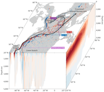
ALT 3d schematic in the North Atlantic showing ocean velocities at the surface and across 20ยฐN (red is northward), and an integrated overturning stream function on the right face. Arrows are overlaid to show the gyre/overturning branches.
Where does that leave us? (1)
- #GulfStream spans Florida to Boston.
- #AMOC spans South Africa to Arctic.
Southern AMOC review (no Gulf Stream needed) from Chidichimo et al. (2023) shorturl.at/kyFNQ@mpc_ocean
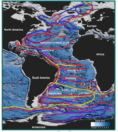
ALT Schematic of the Atlantic circulation patterns, including complexity in the South Atlantic.
Major difference #2: Heat transport
At 26ยฐN, the #gyre moves little heat. ~0.2 PW (0.2 x 10^15 watts).
The #AMOC transports almost all the heat (1.2 PW), even though it only claims a fraction of the #GulfStream.
Johns et al. 2011 (shorturl.at/wADKV)
What about the #AMOC?
No simple theory explains its existence! In fact doesnโt *need* to exist at all (cf. the Pacific, or an AMOC โshut downโ state).
And we canโt write down an equation that describes the flow.
Talley et al 2010 (shorturl.at/cOUV0)
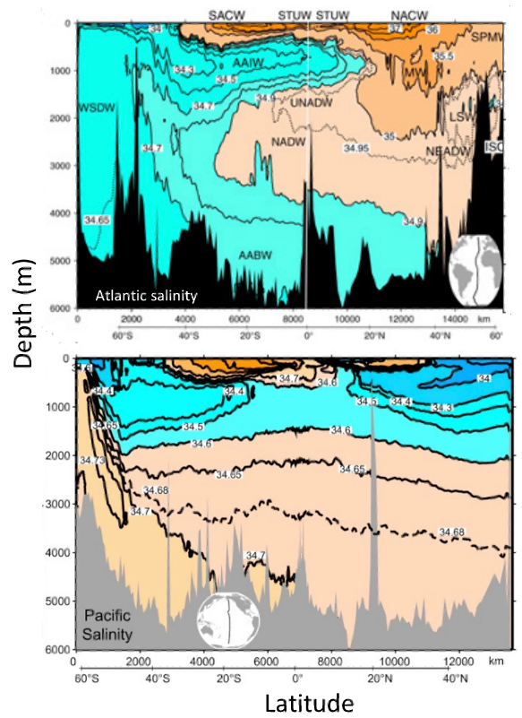
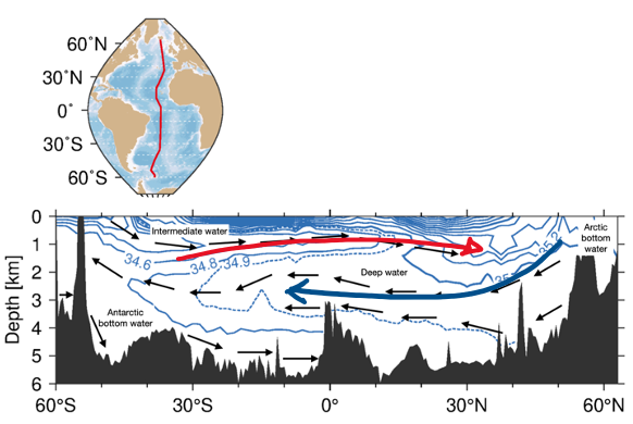
ALT Vertical-latitude sections of salinity in the Atlantic (top) and Pacific (bottom). In the Atlantic, you can see the deep penetration of northern origin waters to 2000-3000m, from which we infer southward flow. In the Pacific, no such connection exists from the surface at northern latitudes to the mid-depth.
Major difference #1: #GulfStream v #AMOC
The gyres are nicely described by theory. We can write an equation for them.
As long as the wind blows and the earth rotates, a gyre will exist. A #GulfStream is essentially unavoidable.
Image from Stommel 1948 (shorturl.at/dfvR0)
Where is the #GulfStream in all this?
Itโs part of both the horizontal and vertical circulations!
It contains the western boundary current of the gyre and the northward limb of the #AMOC in the northern subtropics.
Image from IPCC FAQ 9.3 shorturl.at/ehLR6
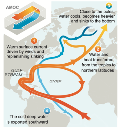
ALT Schematic representation of circulation in the Atlantic where the Gulf Stream (along the east coast of the USA, flowing northwards) splits somewhere offshore of the Atlantic, with one 'branch' flowing northwards as part of the AMOC and the other branch flowing southwards as part of the return circulation of the subtropical gyre.
The overturning goes up and down.
Itโs a vertical circulation (seen in the yz-plane), and described in a integrative sense (across x-dir) where the net effect is to โtipโ the waters over (= overturning).
Only found in the Atlantic. (Ok, the A in #AMOC gives it away.)
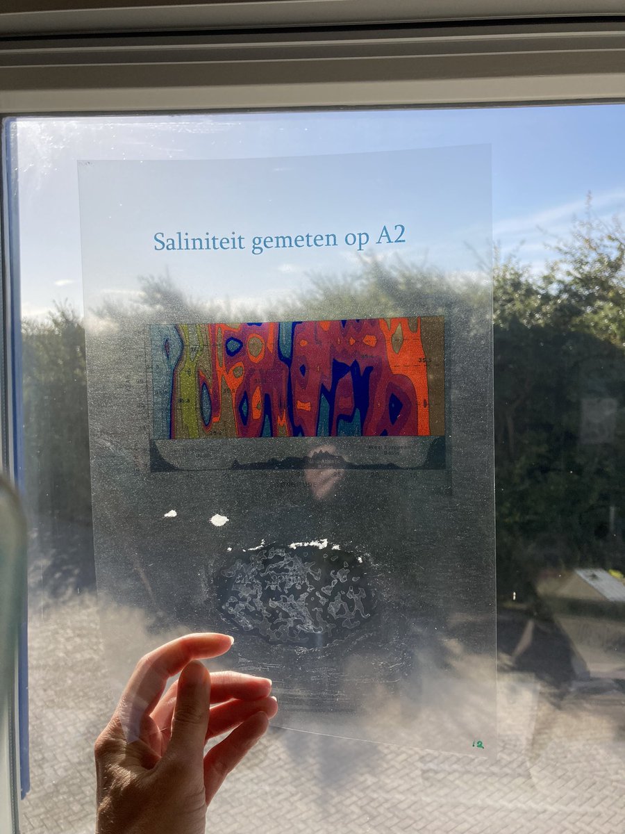
ALT Map showing the position of a north-south track in the Atlantic, and lower panel with salinity section in yz direction. Arrows overlaid show the net direction of circulation (northwards in the top 1000m and southwards from 1000-4000m, and northwards at the bottom).
In the Atlantic Ocean, there are two main large-scale circulations: the gyres and the overturning.
#Gyres go round-and-round.
They are a โhorizontalโ circulation (xy-plane) and are found in multiple oceans.
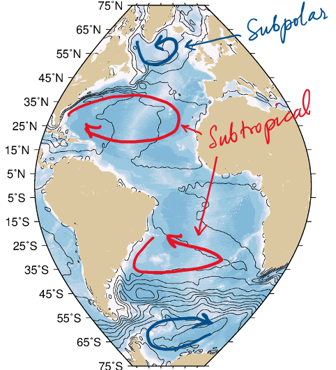
ALT Map of the Atlantic from Antarctica to the Arctic, showing bathymetry in the ocean basins, and contours of dynamic topography. Overlaid are sketched arrows showing clockwise circulation in the northern subtropical gyre and Weddell gyre, and counter clockwise in the southern subtropical gyre and northern subpolar gyre.
Whatโs the difference between the #GulfStream and the #AMOC?
Isnโt it just โyou say potato, I say potahtoโ?
A ๐งต
Image from NASA 2009 (shorturl.at/giw78)
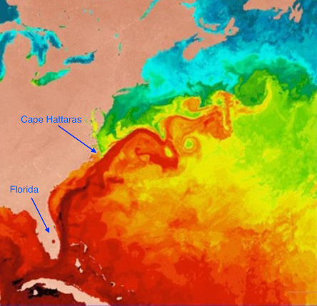
ALT Map of sea surface temperature off the western North Atlantic showing Florida to St. Johns. Strong red colours indicate warm areas and are hottest in the Caribbean and in the Gulf Stream (a warm band just offshore of the east coast of the USA).
Vandaag voorin de krant:Volgens Deense onderzoekers komt de machtige oceaanstroming in de Noord-Atlantische Oceaan, die het klimaat over een groot deel van de wereld regelt, mogelijk al binnen enkele decennia abrupt tot stilstand. @NIOZnieuws@fmkdejongnrc.nl/nieuws/2023/07/26/motโฆ
Will the #AMOC collapse by 2025? Hereโs what we know from direct observations (since 2004).
Image from Srokosz & Bryden (2015) shorturl.at/ryB34
A ๐งต
Summary report in progress. Sneak peak:
- A need to reconcile missing key processes
- New approaches for basin-scale #AMOC understanding
- Compound impacts of AMOC with carbon and cryosphere
- Articulation of societal impacts
Maybe education too. AMOC is not the Gulf Stream.
The world just had the hottest week on record, according to preliminary data. It follows the hottest June on record, with unprecedented sea surface temperatures and record-low Antarctic sea ice extent. #StateOfClimate
๐ bit.ly/44BysFX
After this month of climate extremes worldwide it is appropriate to remember Wally Broeckerโ remark โThe climate system is an angry beast and we are poking it with sticksโ. It is now time to stop pokingโฆ