
You can practically draw the old empires just from the words on this map.
(by @AmazingMaps)

ALT Colour-coded map titled 'How to Say Money in Different European Languages' by Amazing Maps. Germanic languages cluster in yellow/gold (Geld, Penge, Pengar, Penger); Romance languages in red/brown (Dinero, Dinheiro, Argent, Denaro, Dinar); Slavic languages in green/teal (Pieniadze, Penize, Novac, Para); Baltic/Finnish in orange (Raha, Nauda, Pinigai); Russian: Dengi; Ukrainian: Hroshi/Hryvna area. English and Irish both use 'Money'. Greek: Chrimata.
7
2,313


Feb 17
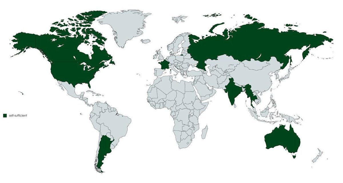
Food self-sufficient countries produce enough food domestically to meet their total national consumption over time. Very few exist!
Domestic production equals or exceeds consumption when measured across all major food categories.
#AmazingMaps
(India's map shown incorrectly)
2
6
22
833

Jan 11
The polling is completely wrong for France, I can't say for other countries but "amazingmaps. shop" is not really an accurate place to get data.
4
230

Jan 2
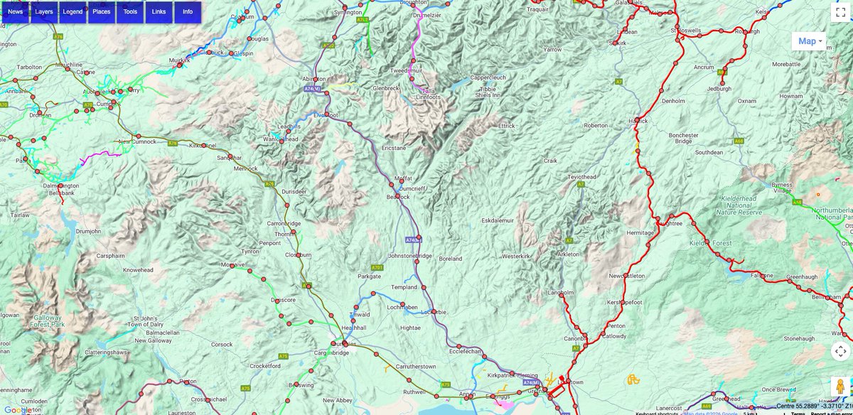
We need to get investment into Dumfries and Galloway area for the railway
Beattock station reopened
Thornhill station reopened
Eastriggs station reopened
A railway link to the ferry again
Electrification of the Dumfries via Kilmarnock line
Location of Stranraer station.
2
76

A profound and long-lasting impact on local, west-to-east and general rural connectivity for huge areas of Dumfries & Galloway and the Scottish Borders @amazingmaps @transportgovuk @transcotland
Excellent historic online mapping resource @Railmaponline
railmaponline.com/UKIEMap.ph…
31 Dec 2025

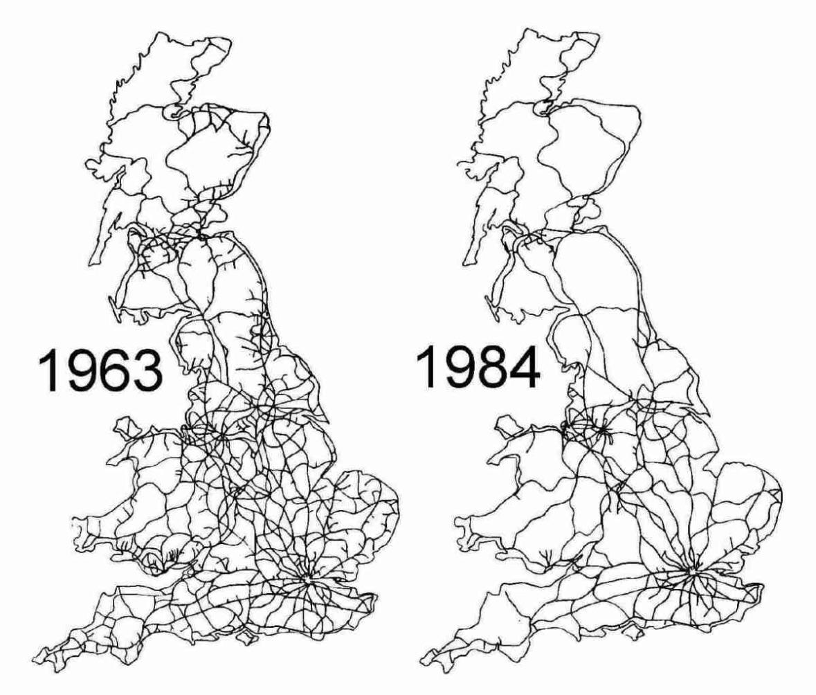
The British railway network before and after the Beeching cuts
In the early 1960s, Britain possessed one of the densest railway networks on Earth. Lines reached deep into rural counties, coastal towns, and industrial districts, reflecting a Victorian system designed for freight, local travel, and a pre automobile economy. By 1963, however, the network was widely viewed by policymakers as financially unsustainable.
That year, Dr Richard Beeching published reports that fundamentally altered British transport policy. Thousands of miles of track and more than two thousand stations were identified for closure. The objective was to concentrate resources on profitable intercity and commuter corridors while eliminating lightly used rural and branch lines.
By the mid 1980s, the results were fully visible. Large areas of England, Scotland, and Wales had lost direct rail access altogether. Road transport expanded rapidly, reshaping commuting patterns, freight logistics, and regional development in ways that still define Britain today.
This map comparison captures more than disappearing lines. It illustrates a national decision to prioritize efficiency over coverage, and a transport legacy that remains debated amid modern efforts to revive rail, reduce emissions, and reconnect isolated communities.
1
1
2
114


This will turn out to be the most accurate map
cc @amazingmaps

2
103


19 Aug 2024
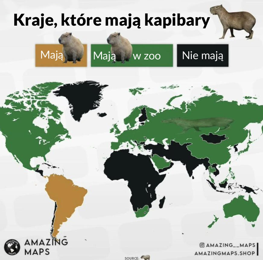
Mapa kapibar: które państwa je mają, a które nie. W Polsce są na przykład w zoo w Poznaniu.
Źródło: AmazingMaps
8
26
2,525

19 Apr 2024
Wow.
Great Britain really kicked some ass in their day. I mean, look at that map! They kicked ass far and wide.
3
225

18 Apr 2024
Hatred in inherent of humanity. It's part of human nature.
Now matter what Ivory Tower Secular Humanists try to claim.
1
24

18 Apr 2024
Interestingly enough, compare this map with present day flashpoints and frozen conflicts. 🇬🇧 did plenty of damage on its way out of places…
1
6
989

18 Apr 2024
United States kicked the Brit’s out 200 years before other nations. Nice
1
461

18 Apr 2024
Important graphic. Too bad the Kurds can't do it, having had the French and the Brits dissolve their country (the Kurds would be a 'problem', don't you know) shortly after WW I. They remain the largest ethnic group in the world without a nation to call their own.
6
1,528

18 Apr 2024
No, certainly not. I'm simply pointing out the reason that Ireland doesn't celebrate independence, not suggesting this is a good or bad thing
1
2
34


18 Apr 2024
yes on their knees = better off. White people will take really good care of them like slaves. that's better off for sure.
3
26

18 Apr 2024
Huge L that these are all on separate days. We all need to coordinate on a single day for a global Fuck England holiday. I’d suggest July 4 of course, but it could also be a floating date that always attaches to the death of the most recent monarch.
3
293