HUMINT or human intelligence as the thing we usually think about as espionage, SIGINT or signals intelligence as the thing that usually is intelligence, and also all the abbreviated forms of intelligence – COMINT, GEOINT, FININT, IMINT, MASINT, OSINT
1
1
3

Job Listing: Geospatial Intelligence (GEOINT) Analyst - Mid: Geospatial Intelligence (GEOINT) Analyst - Mid
Amentum
Newport News, VA mygisjobs.com/job-listing-ge…
27

-___- alright alright. I was hoping for geoint or another espionage related bureau in the Future Country but I will keep it pushing o7o7
2
16

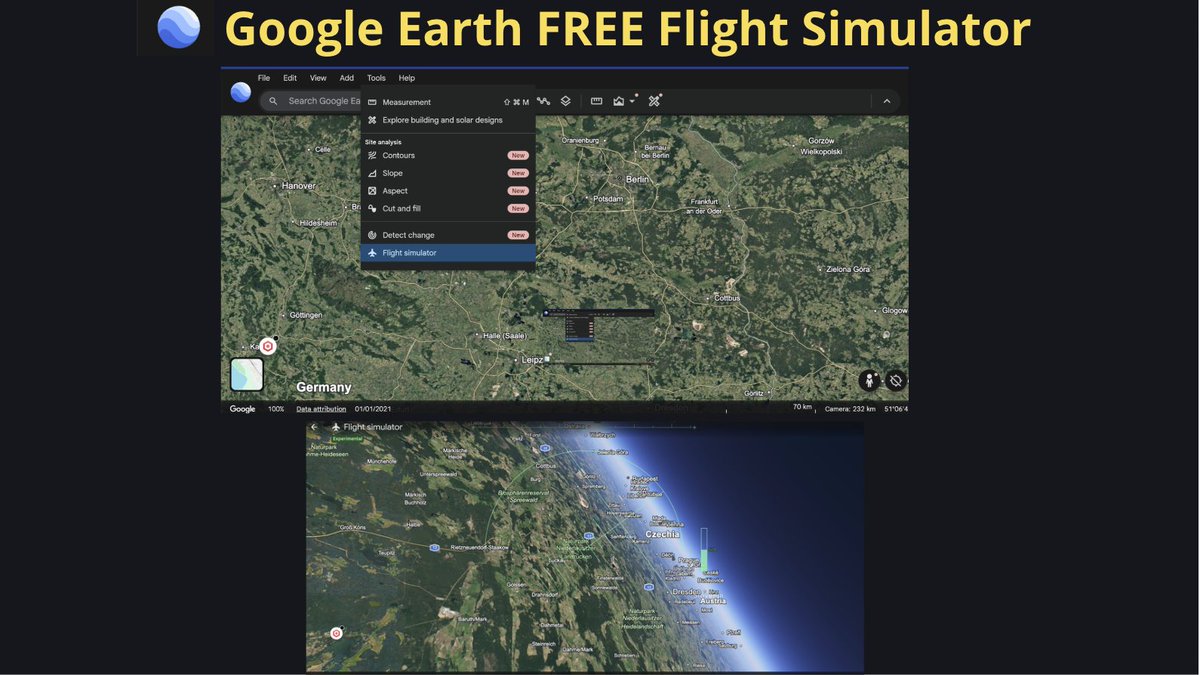
The long-awaited update was released on Google Earth a couple of days ago. Flight Simulator, which was previously available only in the PRO version, is now available in the free online version.
Click Explore Earth -> Tools -> Flight Simulator
earth.google.com/web/
#geoint
6
21
1,834
TELEPORT
Collection of photorealistic 3D captures of different places around the world.
teleport.varjo.com/discover/
To search by location or username, use any search engine and the 'site:' operator.
#geoint

12
30
1,735

Jun 13
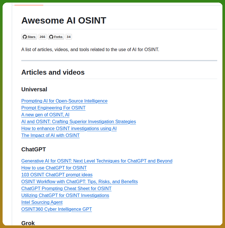
Awesome AI OSINT: One Repository Tracking the Entire AI-Powered Intelligence Ecosystem 🤖💀
AI OSINT = Faster Investigations
Awesome AI OSINT brings together the best AI-powered tools, prompts, guides, GEOINT platforms, face-search tools, and intelligence workflows in one place.
🔗 github.com/ubikron/Awesome-A…
#OSINT #ThreatIntel #AI #CyberSecurity #GEOINT #SOCMINT #OpenSourceIntelligence
2
18
80
2,865

Jun 12
What do YOU think — rigged game or coincidence? Drop your take below. #GEOINT #AmericaFirst
1
5
Jun 12
This isn’t innovation — it’s a coordinated heist at the expense of real national security wins in GEOINT and orbital superiority.
1
3
EarthPartyOn retweeted

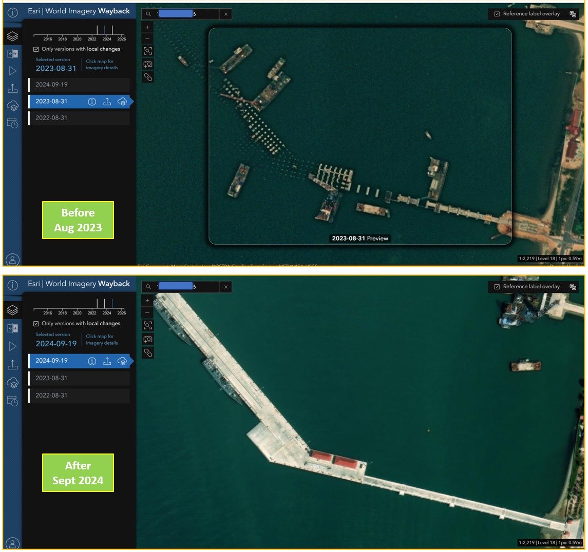
livingatlas.arcgis.com/wayba…
𝐖𝐨𝐫𝐥𝐝 𝐈𝐦𝐚𝐠𝐞𝐫𝐲 𝐖𝐚𝐲𝐛𝐚𝐜𝐤
This OSINT/GEOINT tool lets you compare historical satellite imagery of the same location across different dates.
Useful for spotting changes in infrastructure expansion, site development, port activity, runway changes, construction progress and more.
Enter an address or coordinates, then use the left panel to explore imagery changes over time.
#OSINT #GEOINT #Geolocation
2
28
146
7,465

Jun 12
Planning another CTF competition for the @Limitless_OSINT platform.
This one takes place inside Syria.
Operation Al-Sham will place players inside a fictional intelligence operation built around real geography, real language complexity, real research, and the kind of ambiguity that makes OSINT both difficult and meaningful.
Players will be guided through the mission by SCPO Laura, their handler on the ground, while receiving fragments from Maya, a Syrian civilian source whose voice notes may be the difference between progress and failure. They will also encounter Avin, a Rojava contact who understands the borderlands in a way no map ever fully captures.
This will not be a conventional CTF.
There will be no easy reliance on hidden metadata, simple strings, or challenges that can be solved through one search. Players should expect to work through Arabic, Kurdish, and Turkish place names, real border crossings, Syrian geography, audio intel, and the uncomfortable uncertainty surrounding the intelligence tradecraft in theaters such as Syria.
Why Syria?
Because Syria is one of the most complex intelligence environments I have ever studied. It is a place where geography, language, history, conflict, displacement, ideology, borders, and human survival intersect in ways that force you to become sharper.
Studying Syria and its amalgamation of different elements pushed me to become better at the tradecraft of intelligence. It taught me that a map is never just a map, a name is never just a name, and a source is never just a source.
That is the spirit behind this CTF.
More details soon.
-> limitless-osint.com
#OSINT #GEOINT #CTF #Intelligence #Syria #Rojava #Tradecraft #Turkey

1
101

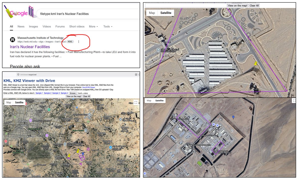
kmlviewer.nsspot.net/
𝗞𝗠𝗟 𝗧𝗿𝗶𝗮𝗴𝗲 𝗪𝗶𝘁𝗵𝗼𝘂𝘁 𝗚𝗼𝗼𝗴𝗹𝗲 𝗘𝗮𝗿𝘁𝗵
During targeted research, if you find a KML/KMZ file, you can view it directly in the browser without opening Google Earth Pro.
No signup required.
Useful for quick OSINT/GEOINT triage.
#OSINT #GEOINT #GoogleDorking
1
6
15
1,138

Jun 12
how close are existing GEOINT capabilities to your skywatch constellation? 80/20?
1
1
121

Jun 12
In the session, @nthgnx covered OPSEC, facial recognition, Google dorking, GEOINT, and SOCMINT before applying the skills to real NCMEC investigations.
Read the full training log here 👇
osint.industries/training-lo…
5
1,438

Learn how #GeoAI can benefit automated workflows like ship or aircraft detection in this engaging and educational blog. The main example given covers detection and classification of grounded aircraft for an entire state as a daily task. #GEOINT
ow.ly/h3ia50Z8XzI
20

Jun 12
June 10, 2026
Strike on a Command Post of the 88th Separate Motorized Rifle Brigade by pilots of the 20th Separate Brigade of Special Unmanned Systems "K-2" in the settlement of Sentianivka, Luhansk region
📍48,6693540, 38,7428349
@GeoConfirmed @Osinttechnical
#GEOINT #OSINT

2
6
144

Most job posts tell you the requisition. They rarely tell you the job.
Great GEOINT analysts notice what others scroll past, explain it so someone can act, and stay honest about confidence.
Sound like you? We're hiring.
#GEOINTjobs

ALT Geo Owl recruiting graphic: headline 'What great GEOINT analysts actually do' over a mission-ops scene, with three traits: notice what others scroll past, explain so a decision-maker can act, be honest about confidence.
16

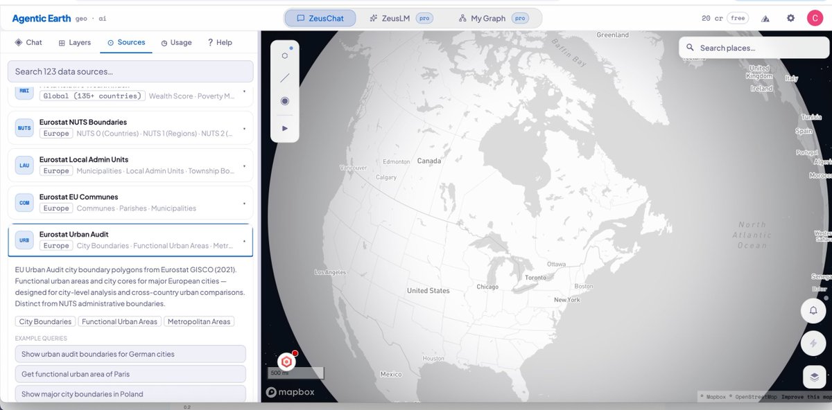
AgenticEarth
An AI assistant with access to 123 geospatial datasets. It allows you to gather a wealth of information about any location on Earth and visualise the results on a map.
Free trial.
agenticearth.app/
#geoint
13
83
3,176