
Googleが「Groundsource」という新しいAI技術を発表しました。これ、都市部のゲリラ豪雨による洪水を最大24時間前に予測できるシステムなんです。
どういう仕組みかというと——
→ 過去の公的な報告書や記録を数百万件単位で集める
→ Google Mapsのデータと組み合わせる
→ Gemini(GoogleのAI)で「いつ・どこで洪水が起きたか」の歴史データベースを作る
→ そのデータでAIモデルを訓練し、未来の洪水を予測
つまり、過去の膨大な「洪水レポート」をAIに学習させることで、これから起こる洪水パターンを見抜けるようにしたわけです。
従来の洪水予測って、河川の水位や降雨量データに頼ることが多かったんですが、都市部の「急な冠水」はなかなか予測が難しかった。でもGroundsourceは、実際に起きた洪水の記録を大量に読み込むことで、都市特有の浸水リスクも捉えられるようになったのがポイントです。
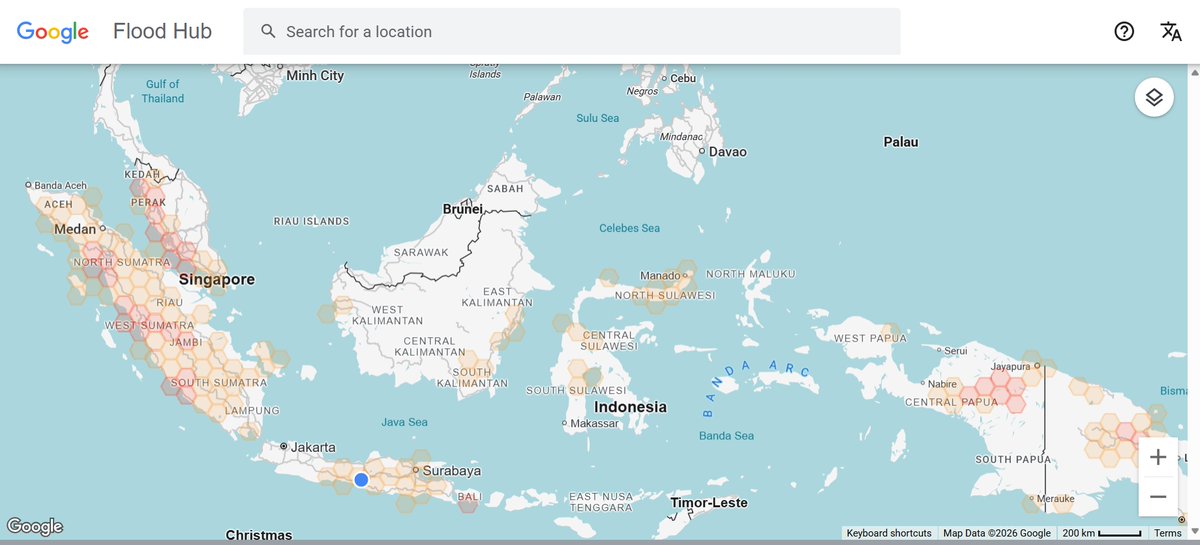
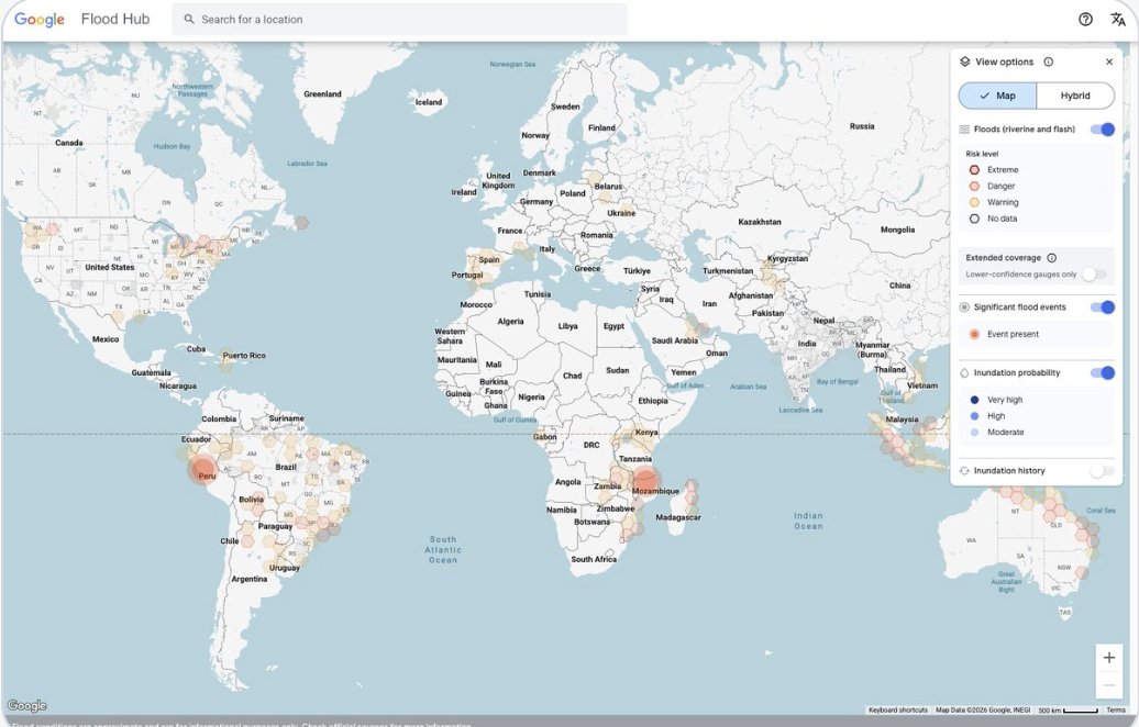
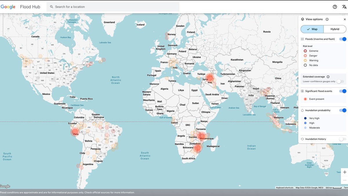
予測結果はGoogleの「Flood Hub」で公開されるので、誰でもアクセス可能。スマホで「明日この地域、洪水リスクあり」って事前に分かれば、避難準備や移動ルート変更もできますよね。
個人的には、AIが「過去の災害記録」を学習材料にするアプローチが面白いなと思いました。データさえあれば、他の自然災害(土砂崩れや山火事とか)にも応用できそう。あなたの地域でも、こういう予測システムがあったら安心ですか?
#AI防災 #自然災害予測 #GoogleAI
blog.google/innovation-and-a…
2
67

Apr 15
Groundsource, la inteligencia artificial de Google capaz de predecir inundaciones con 24 horas de antelación dozz.es/oijr44
2
2
1,151

Apr 14
Del microscopio del Sabio a la inteligencia artificial de GroundSource
santiagoramonycajal.org/2026…

1
1
4
67

The tool, Groundsource, is free to the public, and the goal is to help municipalities prepare for the possibility of a flash flood. Watch AI Explained now on the free WPRI 12 smart TV app. @KaitLouiseWalsh wpri.com/aiexplained/how-goo…
2
1,274

Im with you on these four principles, took the same philosophy but added one more:___5. Verified. The memory artifact isn't just explicit and inspectable, it's cryptographically signed. When multiple models contribute to knowledge, you need proof of who said what, when, and whether it's been tampered with since___
The "File over app" and "BYOAI" principles are especially important, my Knowledge Units are just JSON with Ed25519 signatures so any tool can read them, any model can contribute, and anyone can verify the chain offline without trusting the operator.
The gap in personal wikis (including Farzapedia) is that one model compiles everything. One model's blind spots become the wiki's blind spots. Having multiple models cross-critique surfaces disagreements that a single model would silently smooth away.
The Farzapedia approach is great for personal context, a natural extension is applying same pattern to shared knowledge, where verification matters because you're not the only one relying on it and need objective groundsource truth not controlled by anyone...
acta.today/wiki : same pattern, multi-model, verified
1
2
5
327

New Tutorial: Working with the newly released Google Groundsource flood archive data derived from news articles spanning 25 years and containing over 2.6 million records. Learn how to efficiently work with this data using #Python youtube.com/watch?v=lJHKkLKb…
1
23
122
7,967

Mar 25
2.6 million flood events were hiding in plain sight inside the news. Google just turned them into a training set.
Satellites and traditional databases are too slow to catch urban flash floods. The United Nations disaster database holds about 10,000 high-impact events. You can't train a global AI model on 10,000 data points. Accurately modelling climate resilience requires massive historical baselines that simply didn't exist.
Google researchers built a pipeline called Groundsource to fix this data desert. They pointed Gemini at decades of unstructured global news reports across 80 languages. The LLM translated the text and ran a strict verification process. It separated actual past floods from future warnings. It anchored relative dates to publication timestamps. Then it extracted granular street-level locations and mapped them to standardised spatial polygons.
They essentially turned unstructured text into a structured geospatial dataset. Groundsource generated 2.6 million verified flood events spanning 150 countries. Manual reviews showed 82% of these extracted events were accurate enough for real-world spatial analysis.
This historical baseline immediately upgrades urban flood forecasting. Google is now rolling out near-global urban flash flood forecasts up to 24 hours in advance.
Physical sensor networks take decades to build and deploy. Advanced data engineering provides a massive shortcut.
The world's local news is a perfectly valid historical sensor network...

3
13
85
4,611

Mar 24
Groundsource, powered by Google’s Gemini AI, could alert communities of flash floods a full day ahead. coingeek.com/google-groundso…
10
53

Mar 23
Google 'Groundsource' AI tool promises 24-hour flood alerts
coingeek.com/google-groundso…
1
1
10
309

Mar 19
Tulisan saya di @hariankompas tentang proyek Groundsource dari Google yang memanfaatkan AI untuk menguatkan sistem mitigasi bencana.
Proyek ini menggunakan jutaan data kejadian banjir selama puluhan tahun di ratusan negara untuk melatih model AI yang bisa memprediksi banjir di suatu wilayah selama 24 jam ke depan.
Saya juga mewawancarai Mas @faizkrisnadi yang membuat platform Peta Banjir Indonesia dari data Groundsource.
Semoga data ini bisa dimanfaatkan berbagai pihak agar mitigasi banjir di Indonesia makin baik.
kompas.id/artikel/mengolah-j…
1
13
58
1,965

Mar 18
Beberapa hari terakhir sedang mencermati platform Peta Banjir Indonesia yang dibuat Mas @faizkrisnadi.
Platform ini menampilkan data historis peristiwa banjir yang terjadi di wilayah Indonesia sejak April 2000 sampai Februari 2026. Datanya diambil dari proyek Groundsource yang dikembangkan Google.
Dari data di platform ini, kita bisa dengan mudah mengetahui seberapa sering banjir terjadi di suatu wilayah. Kita juga bisa filter berdasarkan wilayah provinsi, kabupaten/kota, dan kecamatan.
Data seperti ini sangat berguna untuk beragam keperluan, dari cari rumah di lokasi yang gak rawan banjir sampai membangun sistem mitigasi bencana.
Yang mau lihat petanya bisa cek di sini: flood.faizkrisnadi.com/
2
4
15
569

Mar 18
Google built an AI that predicts flash floods 24 hours before they happen.
It's free. It covers your city. Here's how to use it:
Flood Hub is Google's disaster prediction platform. It combines satellite imagery, weather data, and a custom ML model trained on 2.6 million historical flood events across 150 countries.
The coverage: 80 countries, 460 million people in flood-prone areas.
How to set it up:
1. Go to floodhub .google .com
2. Search your location or allow GPS access
3. Check the 7-day flood forecast for nearby rivers and watersheds
4. Enable alerts for your specific area
What you'll see:
- Color-coded risk levels from green to red
- Predicted water levels with timestamps
- Inundation maps showing exactly which streets could flood
- Historical flood patterns for context
The real value: 24-hour advance warning for urban flash floods. That's enough time to move vehicles to higher ground, sandbag doorways, or evacuate entirely.
For developers and researchers: Google open-sourced Groundsource, the dataset powering this. 2.6 million flood events you can use to train your own models. Available on Google Research.
Who should bookmark this:
- Anyone living in flood-prone areas
- Property managers and landlords
- Event planners with outdoor venues
- Logistics companies routing deliveries
- Emergency response teams
The model runs on Gemini 3 and updates continuously with new weather data.
Urban flash floods kill more people than any other weather-related disaster. Most deaths happen because people don't evacuate in time.
A free tool that gives you a full day's warning is genuinely worth knowing about.
Bookmark floodhub .google .com before you need it.
9
26
59
1,107

Mar 17
Del microscopio del Sabio a la inteligencia artificial de GroundSource santiagoramonycajal.org/2026…
2
3
115

Mar 16
AI tool looks to improve flash flood preparedness
Google's Research division has introduced Groundsource, an AI-powered dataset that compiles information on flash floods from millions of news articles to chart rainfall patterns worldwide. ....
3
9
Mar 16
Beberapa hari lalu, Google memperkenalkan sebuah proyek yang dinamai Groundsource. Ini adalah proyek yang memanfaatkan AI untuk mengolah informasi publik menjadi data historis bencana.
Pada tahap pertama Groundsource, Google menyajikan data historis mengenai banjir di berbagai negara. Dalam proyek tersebut, para peneliti menggunakan Gemini untuk menganalisis berita dan laporan publik terkait banjir selama beberapa dekade.
Hasilnya, ada lebih dari 2,6 juta peristiwa banjir yang berhasil diidentifikasi di 150 negara lebih. Para peneliti kemudian menggunakan Google Maps untuk menentukan batas geografis yang presisi untuk setiap peristiwa banjir tersebut.
Dataset mengenai peristiwa banjir selama beberapa dekade itu kemudian digunakan oleh para peneliti di Google untuk melatih model AI yang bisa memprediksi banjir dalam waktu 24 jam ke depan. Sistem prediksi banjir dari Google itu bisa dicek di sini: sites.research.google/floods…
Di sisi lain, Google juga membuka dataset yang berisi 2,6 juta lebih peristiwa banjir di 150 lebih negara. Dataset itu bisa diakses di sini: zenodo.org/records/18647054. Adapun penjelasan lebih lanjut soal Groundsource bisa diakses di sini: research.google/blog/introdu…
Dataset peristiwa banjir historis dan sistem prediksi banjir itu sangat berguna untuk mendukung penelitian dan mitigasi banjir. Para peneliti, jurnalis, lembaga pemerintah, LSM, sukarelawan bencana, dan pihak-pihak lain bisa memanfaatkan data ini.
2
9
17
624

Ada 3 parameter menarik yang bisa digabung/dimasak untuk solusi regional (pemda).
Model forecast (misal dari groundsource ini, udah ready, ga perlu training).
Live data (misal curah hujan harian/mingguan - harusnya bmkg juga ada).
Terakhir historical impact trigger.
Mar 15

cc-kan ke pemda tempat kamu tinggal
biar ga alesan mulu nyalahin takdir
padahal ngaku muslim tapi ga bisa bedain qadha dan qadar
1
1
2
421

Datanya apakah sama dengan yang di Groundsource-nya Google ya, Mas? Di filter hanya untuk Indonesia?
zenodo.org/records/18647054
1
1
7
1,276


Mar 15
Predicts city flash floods 24 hours ahead
Flash Flood Predictions Across 150 Countries
x.com/Mlearning_ai/status/20…
Google released Groundsource, an AI-powered methodology that extracts ground truth from 5 million news articles to create a dataset of 2.6 million historical flood events spanning 150 countries. The dataset trains an LSTM model that predicts urban flash floods up to 24 hours in advance using weather forecasts and geographic data

Cursor Automations vs OpenClaw ACP / Skills vs Claude Code Hooks / Loops
🦞
60 Tips to Build AI That Codes While You Sleep ($0 to $20/mo)

1
1
3
211