
I shared the photo with Grok and asked if they were barnacles. This answer came back… so maybe bryozoans (moss animals) 😊
No, this heart shape is unlikely to be created by barnacles.15
Barnacles are common in intertidal zones on rocks (including man-made concrete/cement structures like seawalls or “cement rocks”) at low tide. They typically appear as small, hard, volcano- or acorn-shaped bumps with plates that can cluster densely, sometimes forming rough patches or even outlining shapes on rocks or shells. However, they don’t usually create smooth, branching, vein-like, or net-like patterns like what’s visible in your image.64
The pattern in the photo—a lighter, interconnected, branching or tubular network on a darker background—looks more consistent with other intertidal encrusting organisms, such as:
•Bryozoans (colonial “moss animals”) — These form flat, lace-like, or branching colonies that can look veiny or net-like.
•Encrusting sponges or tunicates — These create thin, irregular sheets or networks on hard surfaces.
•Tube worms (e.g., calcareous tubes) or similar colonial invertebrates that build interconnected structures.
•Possibly coralline algae or other encrusting growth, though less likely for this exact look.
These organisms thrive in the low-tide intertidal zone on stable hard substrates like your cement rock, where they filter feed when submerged.55
Similar “heart” finds on beaches are often natural erosional shapes, mineral patterns, or growths enhanced by organisms (including barnacles in some cases), but the specific texture here points away from barnacles as the primary creator.63
If you can share the location (e.g., specific beach or coast) or more details/close-ups, it could help narrow it down further—marine life varies a lot by region! Cool find either way; nature loves pareidolia (seeing hearts in random patterns).
1
1
11

⚠️ Sunset on Canvas 🧜🏻♂️
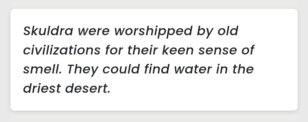
Searching for "Skuldra"
And apart it being a Swedish word for "Shoulder",
It's a character (a tame-able monster) from a game called Coromon- who senses for water in the deserts.
Reminded me of Rafayel (Intertidal Zone) & Abysswalker instantly.
1
4
33
2,508

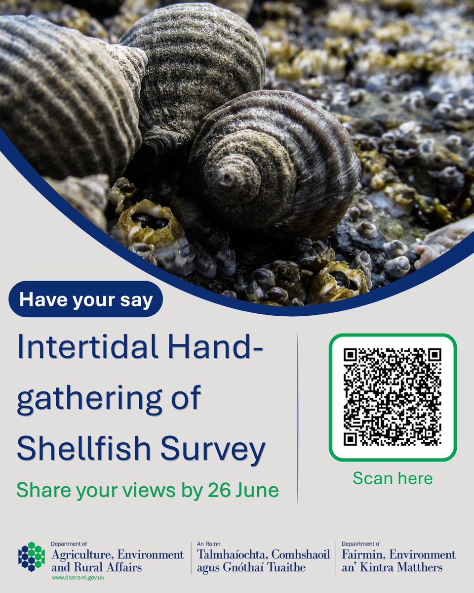
Do you gather shellfish from the NI intertidal area? You can help us get a better understanding of this activity, particularly around the gathering of periwinkles.
🐚Take part in the survey: consultations2.nidirect.gov.…
@nifpo @anifpo @NIMTF @AFBI_NI @cedarrecordsni
104
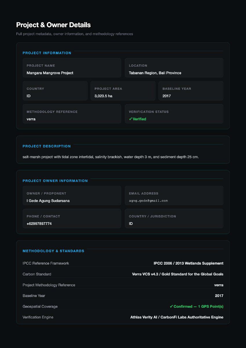
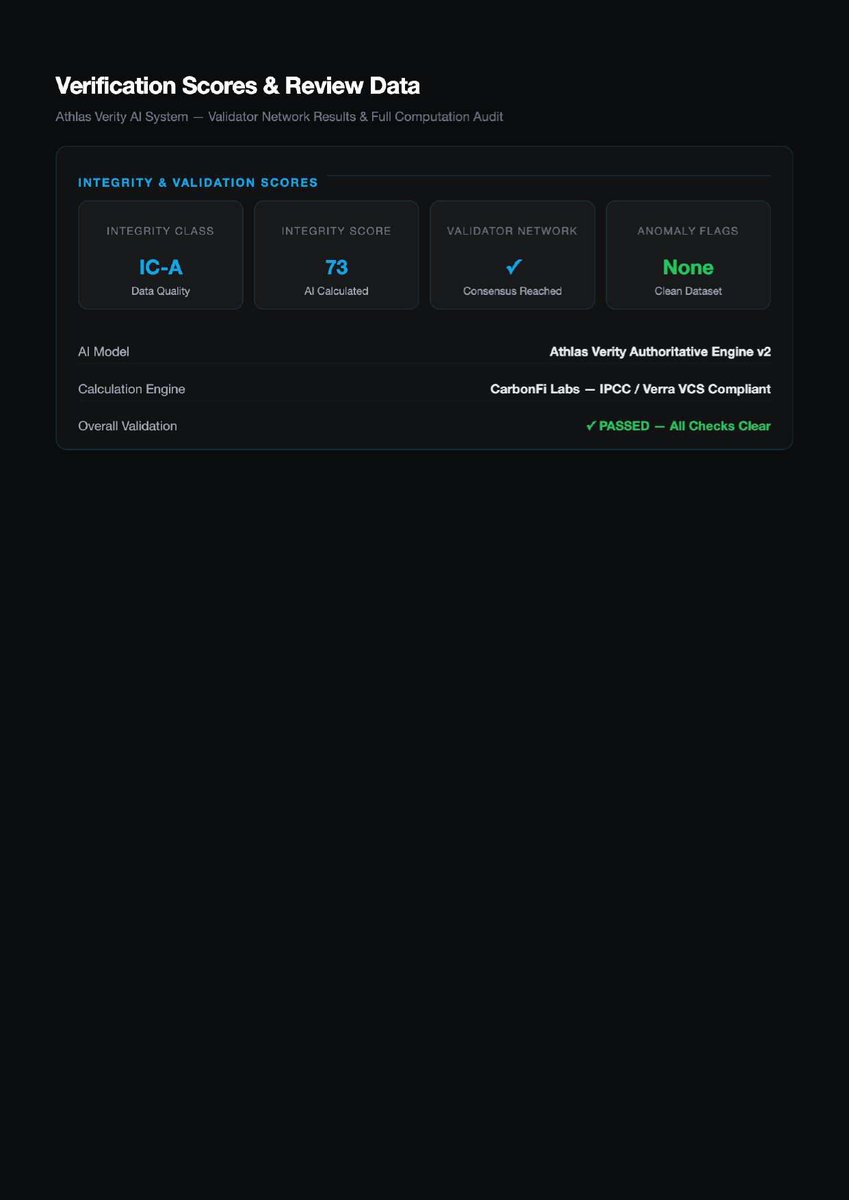
Verified by the Gold Standards of Blue Carbon
The Mangara Mangrove Project report doesn’t cut corners on methodology. It explicitly cites the holy trinity of blue carbon verification:
IPCC 2013 Wetlands Supplement – The international scientific baseline for coastal wetlands, including specific guidance on AGB, BGB, and SOC in mangroves, seagrass, and salt marshes.
Verra VCS v4.3 – The most widely used voluntary carbon standard, with a dedicated Blue Carbon methodology (VM0033 or equivalent).
Gold Standard for the Global Goals – Emphasizes sustainable development co-benefits, including biodiversity and community resilience.
Athlas Verity’s AI engine automatically aligns your blue carbon project data with each framework’s specific rules – including the critical 20% buffer pool deduction for non-permanence risk (storms, sea-level rise, land-use change).
For project developers, this means one submission, one verification report, and multiple pathways to credit issuance (Verra, Gold Standard, or both). For buyers, it means confidence that your blue carbon credits meet the highest global standards.
Mangara proved it works for complex intertidal ecosystems. Now it’s your turn.
Athlas Verity supports IPCC Wetlands, Verra Blue Carbon, Gold Standard, and more.
👉 Join the multi-framework blue carbon future at athlasverity.xyz
@MangaraMangrove @Verra_Standard @GoldStandard @IPCC_CH @BlueCarbonInitiative @RamsarConv @UNEP @ConservationIntl @TheOceanAgency @MangroveEcology
#BlueCarbonMethodology #MangaraMangrove #VerraVCS #GoldStandard #IPCCWetlands #dMRV #AthlasVerity #MultiFramework #HighIntegrity #CoastalCarbon


15
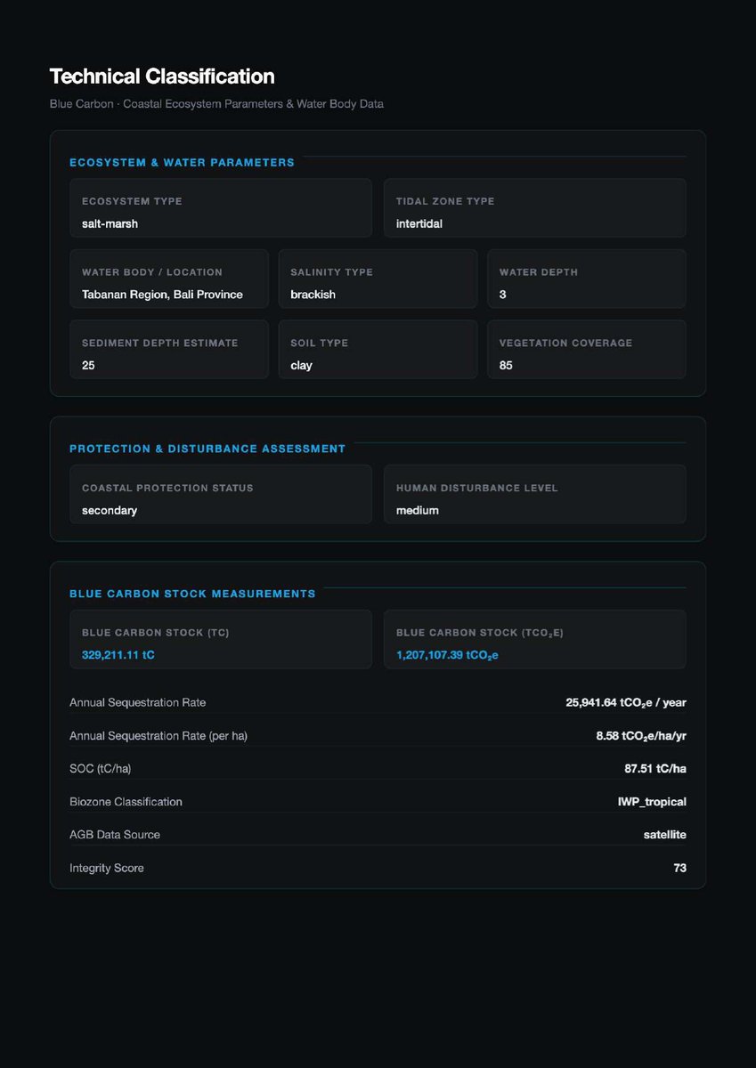
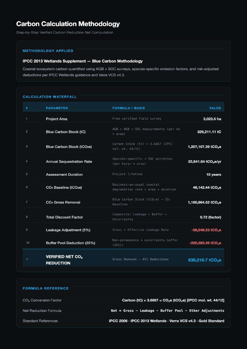
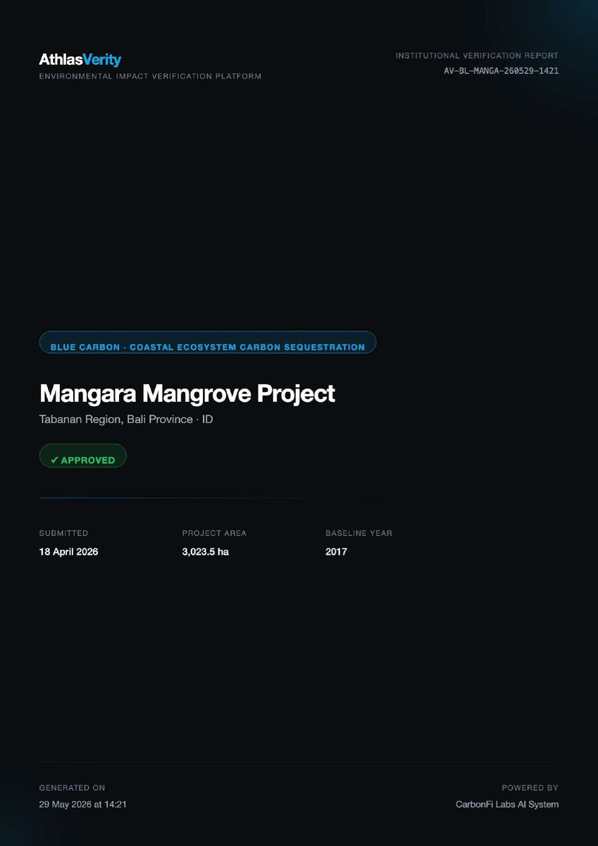
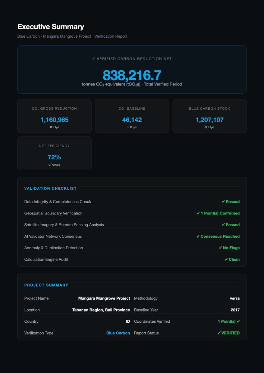
Small Area, Big Impact – How 3,023 Hectares of Mangrove Deliver 838,216 tCO2e
The Mangara Mangrove Project is not the largest blue carbon project by area – 3,023 hectares is modest compared to some forest projects. Yet its carbon density is extraordinary.
Compare:
Tropical forest: ~250–350 tCO2e/ha (above ground only)
Mangara mangroves: ~276 tCO2e/ha above ground – but with SOC included, total blue carbon stock reaches ~399 tCO2e/ha.
That’s 1.5x to 2x denser than many forests. And over 10 years, after applying leakage (5%) and buffer (20%), the net verified reduction is 838,216.7 tCO2e – equivalent to taking 180,000 cars off the road for a year.
Verifying a blue carbon project of this complexity manually would require:
Tidal-adjusted sampling across 3,000 hectares
Soil coring to measure SOC at dozens of points
Species identification for emission factors
Months of analysis
Athlas Verity did it in days. The AI processed tidal filtering, species matching, SOC modeling, and baseline calculations automatically.
If dMRV works for Mangara’s complex intertidal ecosystem, it works for your coastal project – regardless of size or location.
Don’t let complexity delay your blue carbon credits.
👉 Verify your high-density coastal carbon at athlasverity.xyz
@MangaraMangrove @BlueCarbonLab @OceanSolutions @ConservationOrg @WWF @TNC @UNEP @GlobalMangroveAlliance @TheNatureConservancy @CoastalCarbon
#HighDensityCarbon #MangaraMangrove #BlueCarbonImpact #dMRV #AthlasVerity #MangroveDensity #CoastalCarbon #SmallAreaBigImpact #NetZero #ClimateAction


12

Jun 17
MAINLAND urgency dissolves as the road narrows and water edges closer. Canals catch the light. Mangroves replace concrete. Even the air seems to slow, moving at its own pace.
youtu.be/fJF8q3xXfpw
Carey Island lies just off Selangor’s west coast, low and flat against the Strait of Malacca. More than a century ago, this was a mangrove swamp - tidal, waterlogged and inhospitable. In the early 1900s, the land was gradually reclaimed, transforming an intertidal landscape into one of Malaysia’s most enduring agricultural estates.
1
1
28
藁山 retweeted

Jun 17
Gooseneck barnacles (Pollicipes polymerus), a species of stalked barnacle found in the intertidal zone. The red coloration on their stalks is caused by high levels of hemoglobin, particularly in specimens living in areas with strong currents. They are highly regarded as a gourmet delicacy, particularly in Spain and Portugal, where they are known as percebes.

5
24
514

Jun 17
Beyond Validation – How Athlas Verity’s AI Engine Verified Mangara’s Mangroves
The Mangara Mangrove Project report explicitly states: "Verification Engine: Athlas Verity AI / CarbonFi Labs Authoritative Engine." For blue carbon, this AI engine does far more than simple biomass calculations:
Tidal filtering: Automatically selects satellite images captured at lowest tide to expose maximum mangrove vegetation and sediment – critical for accurate AGB and SOC estimates.
Species-specific emission factors: Matches spectral signatures to known mangrove species (Rhizophora, Avicennia, Sonneratia, etc.) and applies appropriate carbon fractions.
Soil Organic Carbon modeling: Combines satellite-derived vegetation indices with optional in-situ sediment samples (when available) to estimate SOC across the entire intertidal zone.
Salinity & water depth classification: Uses Sentinel-2 bands to map brackish/freshwater transitions and water depth zones.
Multi-framework alignment: Runs consensus across IPCC 2013 Wetlands, Verra VCS v4.3 Blue Carbon methodology, and Gold Standard requirements.
For Mangara, this meant verifying 3,023.5 hectares of intertidal ecosystem with only one GPS point and public satellite archives. The AI detected no boundary conflicts, confirmed the tidal zone classification, and validated the 25 cm sediment depth against regional SOC databases.
Your blue carbon project – whether 100 hectares or 10,000 – can leverage the same AI.
👉 Let our blue carbon AI verify your coastal project at athlasverity.xyz
@MangaraMangrove @CarbonFi @AIforGood @ClimateAI @BlueCarbonAI @RestoreCoast @MangroveAction @GlobalMangrove @OpenOcean @EarthObservatory
#BlueCarbonAI #AthlasVerityAI #MangaraMangrove #MachineLearning #dMRV #ClimateTech #SatelliteAI #SmartVerification #CoastalCarbon #MangroveAI


1
37

Jun 16
Meet the black oystercatcher! A bird that eats… limpets? Despite their name, black oystercatchers primarily eat limpets, chitons, whelks, and bivalves that aren't oysters 🤓 They are also monogamous and nest in the intertidal zone!

3

@joshual951 - this temperate intertidal marine zoologist will defer to you on this; especially as I can’t see if the leaves are spotted! @photo_cj (@Lancswildlife has had left X.)

This is probably a common spotted Orchid (noy up on such), seen yesterday in reasonable numbers along the Lancashire Coastal path. @VisitLancashire
@lawt_d @dunnjons @Lancswildlife
Captured from a distance on @OMSYSTEMcameras supplied by @OlympusUK

4
46

Jun 16
Instant follow !
Here’s mine, if there is some intertidal nerds in the audience 🤓
open.substack.com/pub/thelim…
1
91
Jun 16
Added actual seabird sounds to one of my favorite songs 🤓 featuring black oystercatchers and some intertidal sea creatures I found recently in the tide pools
8
Jun 16
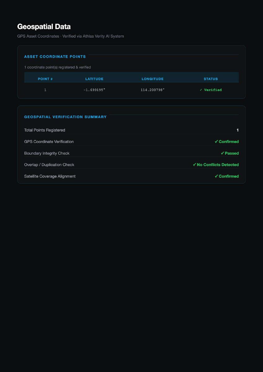
One GPS Point, 3,023 Hectares of Mangrove – Verified from Space
In the Mangara Mangrove Project validation report, a single GPS coordinate was registered and verified: latitude -1.699195°, longitude 114.200798°. That one point, combined with multisource satellite analysis (Sentinel-2, Landsat, MODIS), enabled Athlas Verity to:
Confirm the entire 3,023.5 ha project boundary
Verify intertidal zone classification (salt-marsh, brackish water)
Check for boundary overlaps with neighboring projects or protected areas
Validate satellite coverage alignment across tidal cycles
Pass boundary integrity checks with no conflicts detected
This is the power of geospatial dMRV for blue carbon. Mangroves are dynamic – tides rise and fall, sediment shifts, biomass changes seasonally. Manual ground audits capture a single moment. Satellites capture every moment, every 5 days, across 100% of the project area.
For project developers in coastal regions like Bali’s Tabanan area, this is transformative. No more expensive boat trips, no more mosquito-ridden transects, no more waiting for low tide to measure plots. Just continuous, objective, satellite-backed verification.
Mangara proved it works for blue carbon. Your coastal project can too.
Athlas Verity is production-ready for mangroves, seagrass, and tidal marshes. Upload your boundary. Let our engine verify your blue carbon assets with the same rigor that validated 838,216 tCO2e for Mangara.
👉 Get your blue carbon project verified at athlasverity.xyz
@MangaraMangrove @NASAEarth @ESA_EO @Planet @Maxar @AirbusSpace @BlueCarbonLab @OceanFoundation @RestoreAmerica @WetlandsIntl
#BlueCarbonMRV #SatelliteVerification #MangaraMangrove #CoastalCarbon #dMRV #RemoteSensing #AthlasVerity #MangroveMonitoring #ClimateTech #TidalWetlands


27

Jun 16
Carey Island lies just off Selangor’s west coast, low and flat against the Strait of Malacca. More than a century ago, this was a mangrove swamp - tidal, waterlogged and inhospitable. In the early 1900s, the land was gradually reclaimed, transforming an intertidal landscape into one of Malaysia’s most enduring agricultural estates.
Brought to you by SD GUTHRIE
thestar.com.my/starpicks/202…
thestar.com.my/starpicks/202…
1
1
379
Jun 16
Blue Carbon, Verified: The Mangara Mangrove Project, Bali
Nestled in the Tabanan Region of Bali, Indonesia, the Mangara Mangrove Project spans 3,023.5 hectares of intertidal salt-marsh and mangrove ecosystem. With brackish salinity, water depth of 3 meters, and sediment depth of 25 cm, this coastal wetland is a powerhouse of carbon sequestration – often storing 3–5 times more carbon per hectare than tropical rainforests.
Yet without rigorous verification, its climate value remains invisible to the market.
Thanks to Athlas Verity, project owner I Gede Agung Sudarsana submitted the Mangara project for digital MRV (Monitoring, Reporting, Verification). Using the IPCC 2013 Wetlands Supplement – Blue Carbon Methodology and Verra VCS v4.3 / Gold Standard, Athlas Verity’s AI engine analyzed satellite data, confirmed vegetation classification, tidal zone boundaries, and computed carbon stocks with precision.
The result? A verified net CO₂ reduction of 838,216.7 tCO2e over a 10-year assessment period – derived from a total blue carbon stock of 1,207,107.39 tCO2e after applying leakage (5%) and buffer pool (20%) adjustments.
This wasn’t guesswork. This was geospatial certainty for a coastal ecosystem.
Your blue carbon project – whether mangroves, seagrass, or tidal marshes – deserves the same integrity. Athlas Verity automates the entire verification workflow: upload your boundary, let our satellite-AI engine run multi-framework consensus (IPCC Wetlands, Verra, Gold Standard), and receive an audit-ready report like Mangara’s.
Athlas Verity is live. Blue carbon verification is now automated.
👉 Start verifying your coastal carbon at athlasverity.xyz
@MangaraMangrove @Verra @GoldStandard @BlueCarbonLab @OceanSolutions @ConservationOrg @HighTide @WWF @TNC @ClimateTrade
#MangaraMangrove #BlueCarbon #MangroveRestoration #CarbonCredits #dMRV #Geospatial #AthlasVerity #CoastalCarbon #NetZero #ClimateAction


1
1
48