
May 8
A Look Back at Indian Democracy 🇮🇳
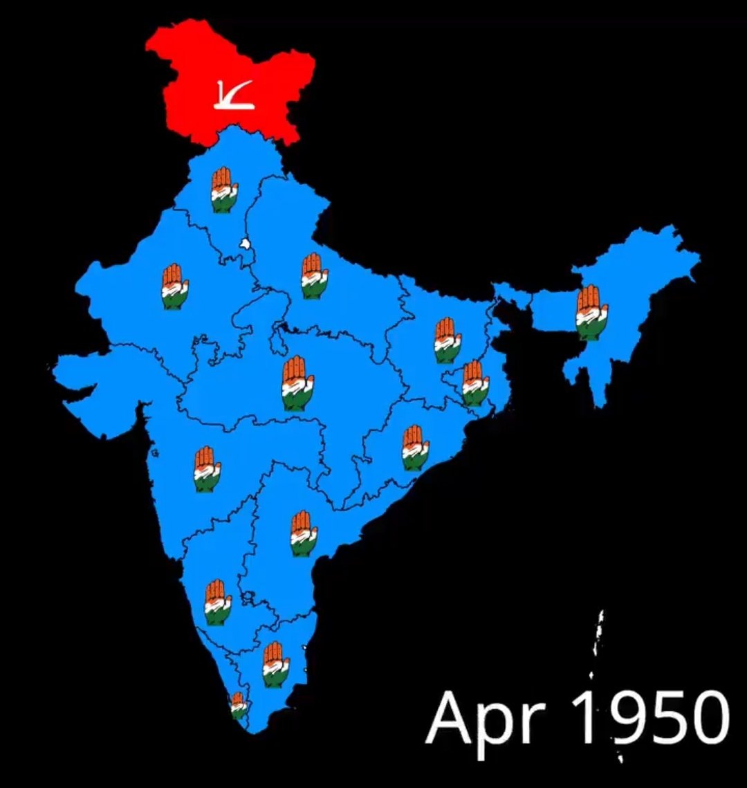
The political landscape of India in April 1950. Following the first Republic Day, the Indian National Congress held a dominant presence across the newly formed states, while the Jammu & Kashmir National Conference (represented by the plough symbol) led in the north.
A fascinating snapshot of a young nation finding its feet. 🗺️🗳️
#IndianHistory #Democracy #1950s #MapHistory
2
4
291

Apr 17
The American population map is shifting — and the movement is anything but random. This map of “U.S. Population Growth by State (2020–2025)” reveals a clear regional pattern: strong gains across much of the South and Mountain West. Slower growth — or even decline — in parts of the Northeast and West Coast.
States like Texas ( 8.8%), Florida ( 8.8%), Idaho ( 10.4%), Utah ( 8.2%), and Arizona ( 6.5%) stand out as major growth leaders. Meanwhile, states such as California (-0.5%), New York (-0.9%), Illinois (-0.8%), Louisiana (-0.9%), and Hawaii (-1.5%) show population losses during the same period. The national average sits around 3.1%, but the variation from state to state tells a much bigger story.
A few things that make it especially fascinating:
- The South has added more residents since 2020 than all other U.S. regions combined, continuing a decades-long “Sun Belt” shift.
- Idaho’s double-digit growth highlights how smaller states can see dramatic percentage increases even with modest raw population gains.
- Population loss in large states like California and New York reflects a mix of domestic migration, housing costs, remote work flexibility, and slower international immigration during the early 2020s.
- States with no income tax, lower housing costs, and warmer climates have been particularly attractive to movers.
- Regional growth differences can reshape political representation, since congressional seats are apportioned based on population.
Maps like this show that America isn’t just changing — it’s relocating. Economic opportunity, climate, affordability, and lifestyle preferences are quietly redrawing the country’s demographic landscape.
#Texas #Maps #Cartography #USPopulation #Demographics #SunBelt #MigrationTrends #AmericanGeography #DataVisualization #PopulationGrowth #MapHistory #GeographyMatters

1
4
376
Apr 12
Y'all Texas is tops!
How fast can you legally drive depends entirely on which state line you just crossed. This map of maximum speed limits across the United States reveals how transportation policy varies from coast to coast — and how geography shapes driving culture.
While the federal government sets certain highway safety standards, individual states determine their own maximum posted speed limits. In much of the Northeast and parts of the Pacific Coast, top limits tend to remain at 65 or 70 mph. Move into the wide-open spaces of the Great Plains and the Mountain West, and limits climb to 75 or even 80 mph. Texas stands out with an 85 mph stretch — the highest posted speed limit in the country.
A few things that make it especially fascinating:
- Western states with long, sparsely populated highway corridors often allow higher limits due to road design and lower traffic density.
- The 85 mph limit in Texas applies to a specific toll road near Austin, reflecting how engineering standards influence legal limits.
- Historically, the U.S. once had a national maximum speed limit of 55 mph during the 1970s energy crisis, showing how federal policy can temporarily override state control.
This map shows how speed is geographically negotiated — where open landscapes, infrastructure design, and state policy combine to determine how fast America moves.
#Texas #Maps #Cartography #MapHistory #UnitedStates #SpeedLimits #TransportationGeography #PoliticalGeography #Infrastructure #HighwayHistory #GeographyMatters

6
7
21
1,021

Mar 16
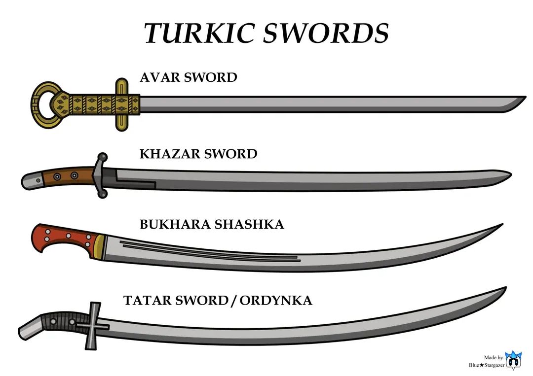
Turkic & Timurid Swords: Colored Charts
What can a sword tell us about history?
Across the vast landscapes of Central Asia, Persia, and Anatolia, Turkic and Timurid warriors carried weapons that were not only tools of war—but also symbols of craftsmanship, culture, and power. Today, colored charts and diagrams of Turkic and Timurid swords allow historians and enthusiasts to visualize how these weapons evolved across centuries.
From the curved elegance of early Turkic sabers to the refined blades used during the Timurid Empire under Timur (Tamerlane) in the 14th–15th centuries, these swords reflect a fascinating blend of steppe traditions and Persian metallurgy. Their distinctive curvature made them highly effective for cavalry combat, perfectly suited to the fast-moving tactics of steppe armies.
Charts comparing these blades often highlight differences in blade curvature, hilt design, guard shape, and decorative elements. Some swords emphasize practicality and battlefield efficiency, while others display intricate inscriptions, gold inlays, or symbolic motifs that reflect the prestige of their owners.
For historians and map lovers alike, these weapons are more than artifacts—they represent the military networks and cultural exchanges that stretched from Mongolia to the Middle East and Eastern Europe. Just as trade routes connected cities and empires, technologies of warfare also traveled across this vast Eurasian landscape.
When visualized through detailed charts, the evolution of these swords becomes almost like a map of cultural influence, showing how ideas, craftsmanship, and military traditions spread across continents.
Question for the community:
If you could hold one historical weapon connected to a great empire, would you choose a Timurid saber, a Roman gladius, or a Viking sword?
#HistoricalMaps #TimuridEmpire #TurkicHistory #Cartography #MilitaryHistory #AtlasBookshelf #MapHistory #SteppeEmpires #WorldHistory #HistoricalWeapons

8
278

9 Nov 2025
Day 9 — Analog 🪶
Scenographia Systematis Copernicani — a 16th-century depiction of the heliocentric world system. Nicolaus Copernicus placed the Sun near the center of the Universe, forever changing our cosmic map. ☀️🌍✨
#30DayMapChallenge #Analog #MapHistory #Cartography

ALT Scenographia Systematis Copernicani
2
132

8 Oct 2025
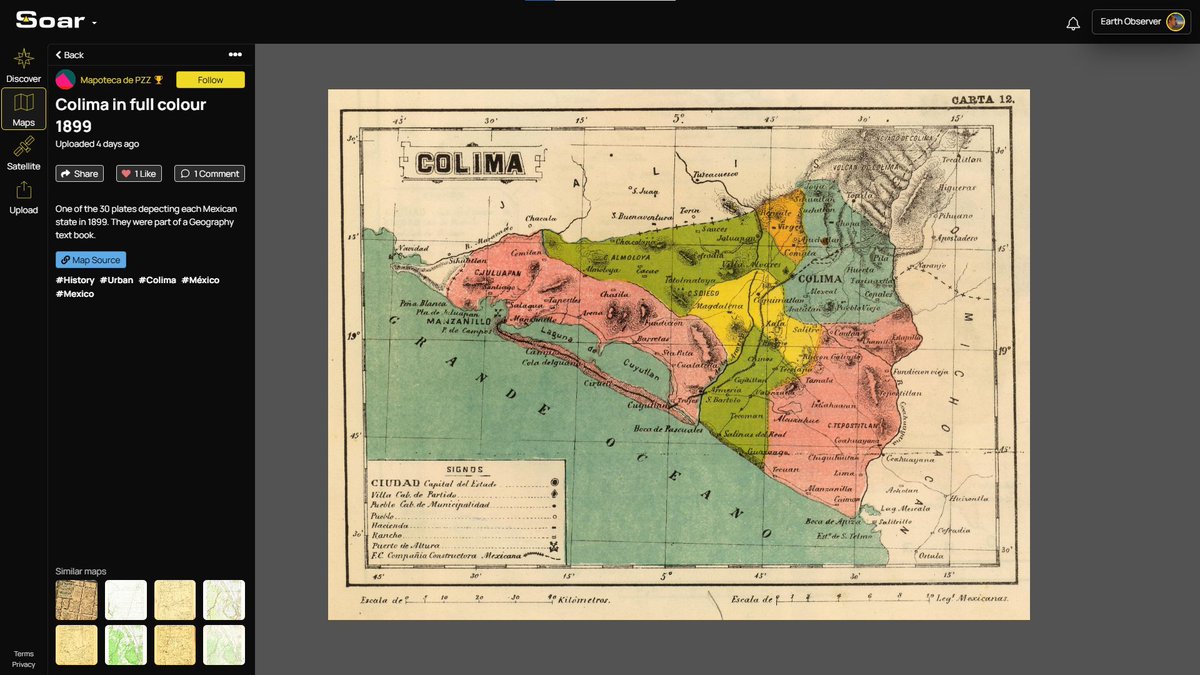
🗺️ Colima in full colour, 1899.
One of 30 beautiful plates depicting each Mexican state. In 1899, Colima was a much smaller, rural place, mostly coastal lowlands rising into mountainous interior.
Explore the map on Soar: soaratlas.com/maps/colima-in…
#VintageMaps #Cartography #HistoricalMaps #MapHistory
3
357

4 Oct 2025
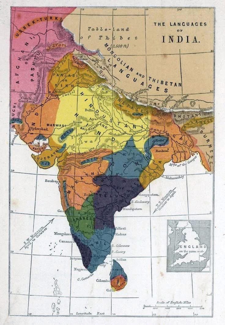
Linguistic Map of India, 1862 — A Colonial-Era Vision of Diversity
The 1862 linguistic map of India is a fascinating historical document — one of the earliest attempts to chart the immense linguistic diversity of the subcontinent. 🇮🇳✨
Created during the British colonial period, this map reflects how 19th-century scholars viewed India’s languages through the lens of empire and emerging linguistics.
🧭 What It Shows:
• Major language families such as Indo-Aryan, Dravidian, Tibeto-Burman, and Austroasiatic
• Broad zones rather than precise boundaries — reflecting limited data and colonial classification
• The colonial interest in mapping language as part of administration and ethnographic study
📜 Historical Context:
• Part of early philological efforts influenced by figures like Sir William Jones and the discovery of Indo-European links
• Reflected British efforts to understand India’s peoples for governance, but often oversimplified complex linguistic realities
Today, we recognize that India’s linguistic landscape is even richer and more fluid — with hundreds of languages and countless dialects, shaped by history, migration, and cultural exchange. 🌍💬
The 1862 map stands as both a testament to diversity and a window into colonial knowledge-making.
#LinguisticMap #India #HistoricalMaps #LanguageHistory #ColonialIndia #Philology #Toponymy #IndoAryan #Dravidian #LinguisticHeritage #MapHistory #CulturalDiversity
11
505

7 May 2025
9/ Fun fact: The Ottoman Empire called it the "Gulf of Basra" in the 16th century, and some maps used local names like "Mare El Catif." But "Persian Gulf" always returned as the standard. #MapHistory
#PersianGulf
#persiangulfforever
1
2
57

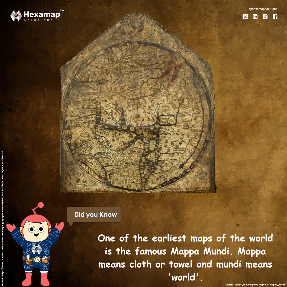
27 Jan 2025
The Mappa Mundi, one of the earliest world maps, where "Mappa" means cloth or towel, and "Mundi" means world, showcasing historical cartographic art.
.
#MappaMundi #HistoricalMaps #Cartography #AncientGeography #MapHistory #HexamapSolutions #MappingTheWorld #DidYouKnow #Hank
2
33

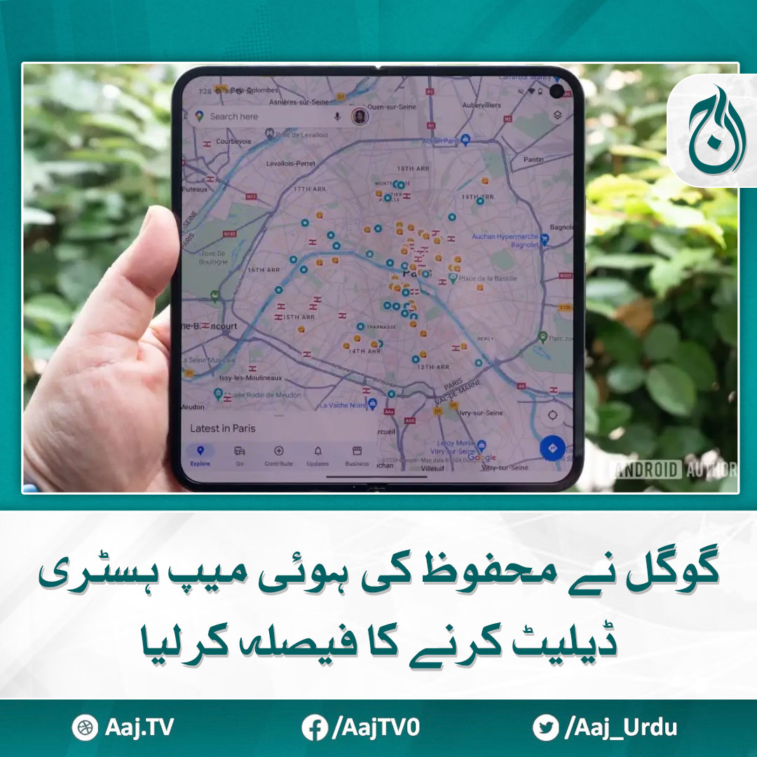
28 Nov 2024
یوزرز کو تین ماہ سے زیادہ پرانی لوکیشن ہسٹری محفوظ کرنے کا مشورہ دیا گیا ہے۔
مزید پڑھیے : aaj.tv/news/30425434/
#AajNews #google #maphistory #privacy #datadelet
1
668

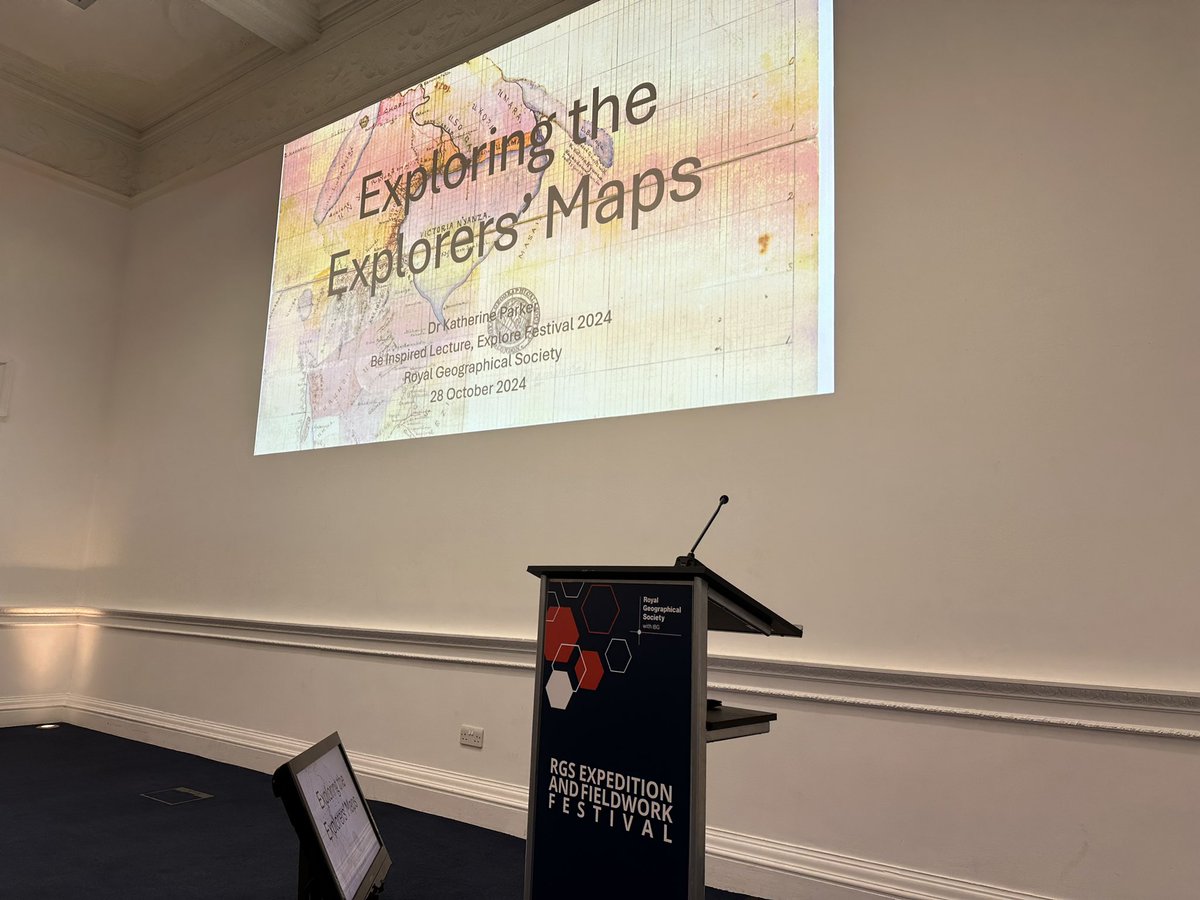
28 Oct 2024
Had a great time kicking off #ExploreFestival @RGS_IBG with a lecture on the types of questions we ask of maps tied to the history of exploration.
The audience had compelling questions and I look forward to seeing some of them in the reading room soon! #maps #maphistory
1
1
10
310

24 Oct 2024
📢For those interested in #RuralHistory, #EnvironmentalHistory, #LandscapeArchaeology, #ArchaeologicalSurvey & #MapHistory, our new paper “Marginal Mounds and Maritime Shepherding” @JnlWetlandArch covers all those topics.
👉Check it out doi.org/10.1080/14732971.202…
🧵below (1/8)
1
2
2
498
10 Oct 2024
Finally out: new research on Pieter #Pourbus, a mid-16th-century artist and mapmaker, who produced highly accurate maps of the coastal area around Bruges (Belgium). How did he achieve such a precision? Find out in this 🧵or in the 📰👇 #MapHistory #cartography (1/7)
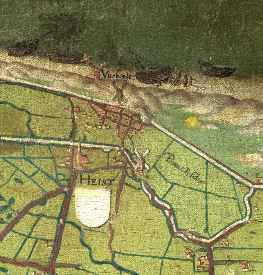
ALT Pieter Pourbus' map of the Liberty of Bruges, Musea Brugge 0000.GRO0220.I , https://dam.museabrugge.be/iiif/3/1619/manifest.json
2
2
10
633

️Maps are portals you can hold
Mapping breathes life into the invisible.
Where will your map (@dp_proto)take you today? #MapHistory #TravelTuesday #ExplorationMode
2
5
108
30 Jun 2024
Started the #mappy times with a curator meeting @laBnF Richelieu. Amazing to see the site emerge from construction. Am of course in awe of their stores and collection. #maphistory #ichc2024


3
8
560
9 Dec 2023
Most of the articles from the latest issue of @imagomundiijhc are now online! This issue focuses on maritime charting, with articles covering the 13th to the 19th centuries. #maps #maphistory
Check out the articles here: tandfonline.com/action/showA…
3
8
564
6 Dec 2023
. #twitterstorians, share with prospective #PhD students! #mapping #maphistory
“Ethnographies of border mapping” is a Collaborative Doctoral Award project between @durham_uni & @RGS_IBG starting autumn 2024
Project: northernbridge.ac.uk/media/s…
Application: northernbridge.ac.uk/applyfo…
4
3
430

29 Nov 2023
Check out the 1st talk of RBS’s Summer ‘23 Lecture Series w/ @maxedelson of @UVA_History on survey knowledge in #maps from empire to independence: youtu.be/qGJ9g24I7lA?feature…
#maphistory #cartography #americanhistory #printinghistory #britishhistory #colonialhistory #twitterstorians

1
5
684
25 Oct 2023
Very excited that the theme for @RGS_IBG’s 2024 Annual Conference will be mapping! Will be working with @Stephenlegg11 to ensure our collections and map scholars are part of the wonderful event. #maps #maphistory
rgs.org/research/annual-inte…
4
10
6,770
17 Oct 2023
The deadline for the J. B. Harley Research Fellowships in the History of Cartography is fast approaching! Get those applications in by 1 Nov for those wanting to do #maps research in UK collections! #fellowships #research #maphistory
For more info here: maphistory.info/application.…
7
6
1,306