
20 Feb 2022
See the before and after of the Olympic Park in Stratford. This development was captured multiple times throughout the construction process in the OSMM Topography Layer.
Celebrating the 20th anniversary of the MasterMap Topography Layer: ow.ly/I2es50HYt8m
#OSMasterMap
3
10
7 Feb 2022
Looking back at our data from the last 20 years, we've compared different features which made up the landscape of Great Britain in 2001, and then in 2021.
Discover what the Topography Layer archive can tell us about our changing nation: ow.ly/iuR650HLoSb
#OSMasterMap
3
14
2 Feb 2022
We're celebrating 20 years since we launched the OS MasterMap Topography Layer - the most detailed and geographically complete dataset of Great Britain.
See how it has been used over the last two decades:
ow.ly/QATh50HIgQ0
#OSMasterMap #DigitalMapping #SeeABetterPlace
1
6

22 Apr 2021
Yes, this is about our work!
Read about how we used missing #GPS signals to build #3D #maps of #cities -
Thanks to our #ukriflf project's partner @OrdnanceSurvey #data (#OSMasterMap #OpenData API) we can build & evaluate accuracy of our #3DModel
bit.ly/3tHiR5v

21 Apr 2021

'As well as using OS MasterMap information internally for our algorithms, we hope to use our results and the OS OpenData APIs in our app to generate a 3D representation.'
Find out more about this @UofGlasgow project from @lines_terry👉 ow.ly/ea5V50EueiY

6
17

20 Sep 2019
#foss4guk2019 #FOSS4GUK Michael Gordon from @OrdnanceSurvey now talking about opening up #OSMasterMap

2
6

18 Sep 2019
Great explanation by @maddiemoate about the #surveying and #cartography work of @OrdnanceSurvey to create and update the #OSMasterMap® often used by students in @Digimap4Schools and @ArcGISOnline incl #GPS and #GIS 07.29-14.10 @EYPPC_GA @GIS4Schools @geogologue
18 Sep 2019
As part of @CBeebiesHQ’s programme Do You Know?, @maddiemoate visited our HQ to learn how maps are made🗺️
ICYMI catch up on @BBCiPlayer: ow.ly/lXtE50wdC3T
2
3
8

14 Jun 2018
Key parts of the #OSMasterMap will be made openly available for the public and businesses to use. Join @Geovation if you want to see how this data could grow your #PropTech & #GeoTech #startup. Find out more on our blog social.os.uk/osmastermapstat…

14
17

23 Feb 2018
Back to @ODILeeds today to find out more about the Geospatial Commissions plans to drive economic growth by making #OSMasterMap data more accessible.
I look forward to hearing what they have in mind.
3
5

23 Nov 2017
When it eventually happens this will be great news for OSMM derived #geospatial data publishers and onward use of derived data products by innovators/developers #opendata #osmastermap #Budget2017
22 Nov 2017

UK government commits £40m/year for 2 years to support opening OS MasterMap! gov.uk/government/publicatio…
6
4

12 Jun 2017
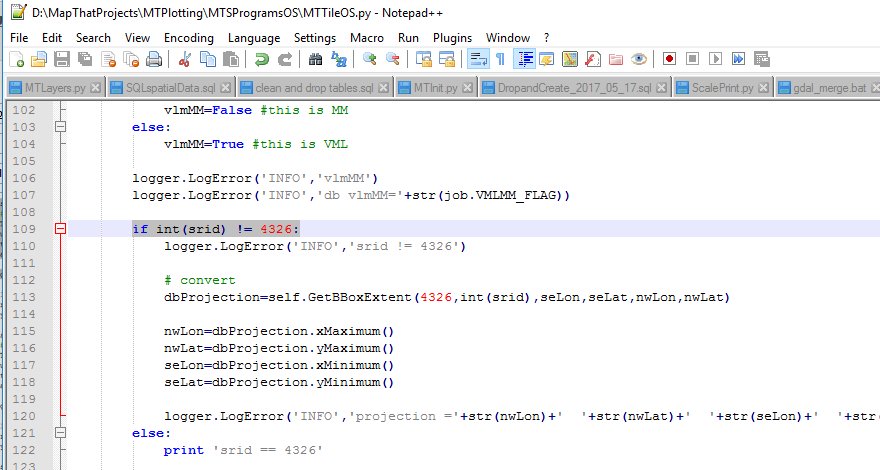
#MapThat Admin – Scale Printing using WGS 84 (Long Lat) 4326 ow.ly/KzYo30cvLPa #OSMasterMap #DynamicMaps


25 Nov 2016
Happy to support OSMasterMap schema9 in OSTranslatorII for @QgisUK if @OrdnanceSurvey become @QGIS gold sponsors #QGIS3NeedsYou
6
6

Here are some fast facts about out most popular product, OS MasterMap, for any stats fans out there @OrdnanceSurvey #OSMasterMap #stats
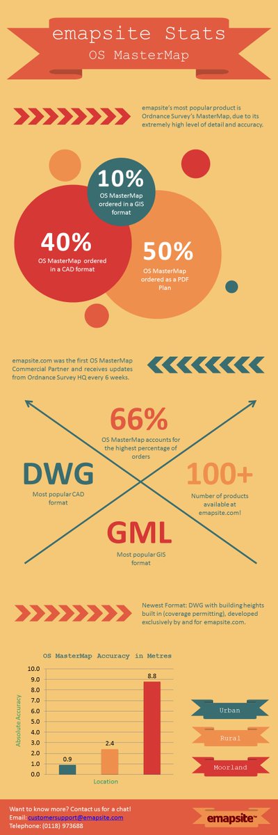
2
2

28 Jul 2016
Member News: @OrdnanceSurvey partners @emapsite & @LeicaGeoUK launch #OSMasterMap on demand for field workers social.os.uk/FebEQ
1
1
19 Jul 2016
OS partners @emapsite & @LeicaGeoUK launch new service to give field workers access to #OSMasterMap on demand. social.os.uk/FebEQ
1
4
New partnership with @LeicaGeoUK enables field workers to access @OrdnanceSurvey #OSMastermap on-demand. emapsite.com/news/viewnews.a… #survey
1
3

23 Oct 2014
4
1