
Tech Tuesday | Dharmavana Nature Ark
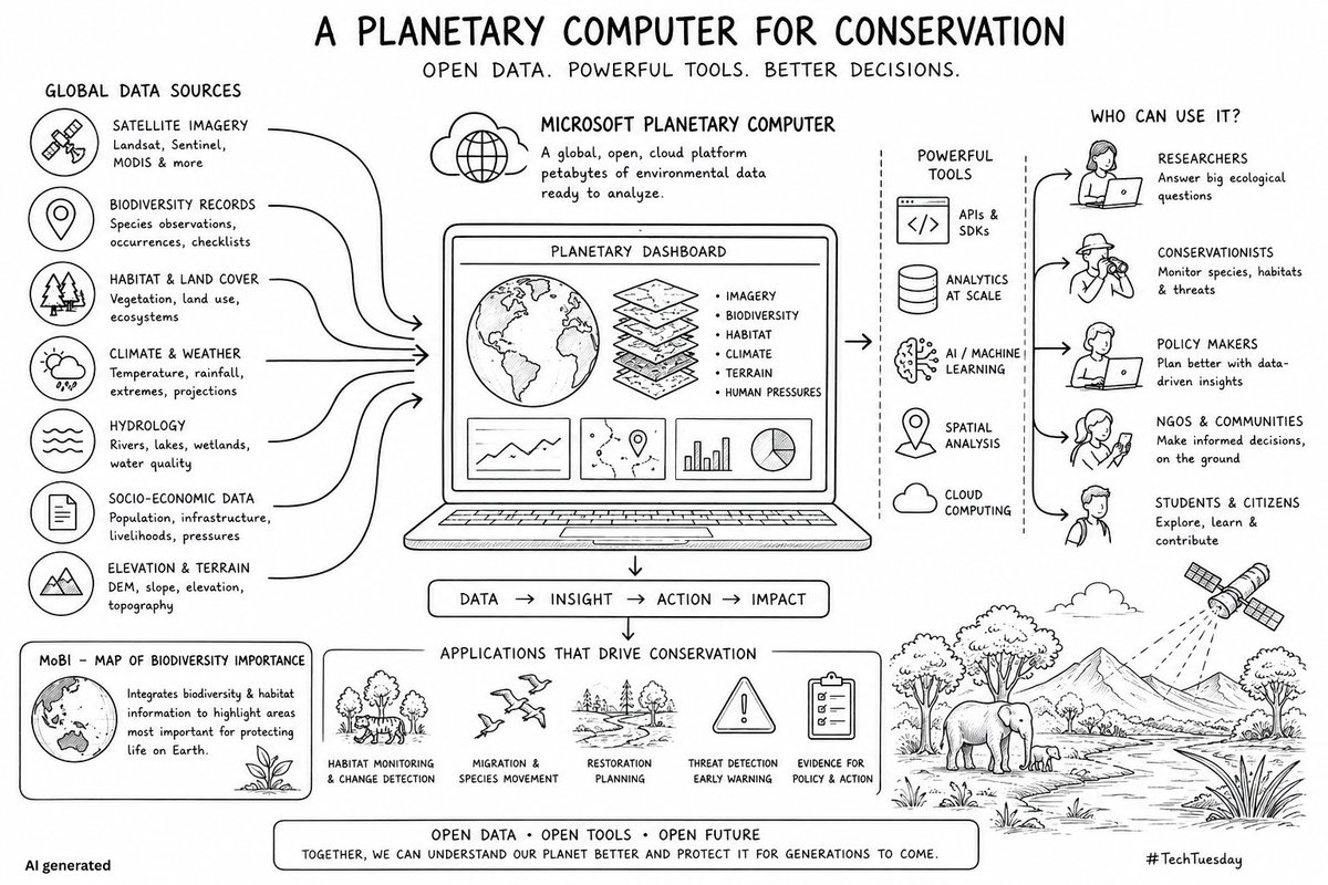
What if every conservationist had access to a planetary-scale computer?
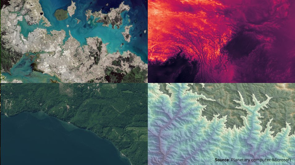
Not a supercomputer sitting in a research lab. A shared digital infrastructure containing petabytes of satellite imagery, biodiversity records, climate data, land cover maps, weather information, and ecological datasets from around the world.
This is the idea behind Microsoft's Planetary Computer.
At first glance, it looks like a massive environmental data repository. But its real significance lies elsewhere. It is attempting to solve one of the biggest challenges in conservation today: access.
For decades, valuable environmental data existed in silos. Researchers spent months finding datasets, cleaning them, converting formats, and building workflows before they could even begin answering ecological questions. The Planetary Computer flips that model. Instead of bringing data to the scientist, it brings the scientist to the data.
A biodiversity researcher can combine satellite imagery with species occurrence records. A conservation planner can overlay habitat maps, climate projections, and land-use change data. A student can access datasets that were once available only to large institutions.
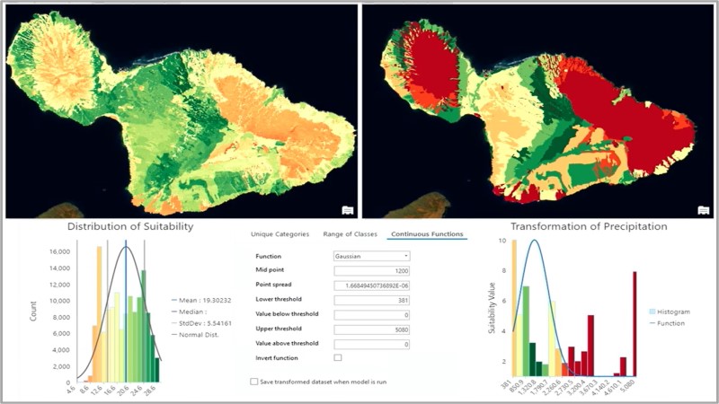
One dataset that caught our attention is MoBI (Map of Biodiversity Importance). It brings together habitat information and biodiversity priorities into a format that can directly support conservation planning.
lnkd.in/gBCUx2Ta
While MoBI currently serves the United States, it offers a compelling model for countries like India to develop their own biodiversity intelligence platforms tailored to local ecosystems and conservation priorities.
What is fascinating is not the technology itself. It is the philosophy behind it.
The future of conservation may depend less on discovering new data and more on making existing data accessible, interoperable, and usable by everyone. Imagine if India had a similar open platform.
Forest inventories. Species records. Wetland maps. Camera trap datasets. Restoration projects. Herbarium records. Climate projections. Satellite imagery.
All searchable. All connected. All available to students, researchers, policymakers, startups, NGOs, and citizens.
The next breakthrough in conservation may not come from a new satellite or a new sensor. It may come from a young researcher who suddenly gains access to information that was always there but impossible to connect.
The future of conservation is about protecting nature AND building the tools & infrastructure that helps us understand it.
#TechTuesday #Dharmavana #PlanetaryComputer #OpenData #ConservationTechnology #Biodiversity #CitizenScience #ClimateAction #GIS
34

20 Oct 2025
🎯 AI Agents for Microsoft Planetary Computer: Explore Satellite Data with Zero Code
Unlock satellite data without writing a single line of code! 🌍 In this step-by-step tutorial, you’ll discover how to harness the power of AI agents to search, filter, and visualize geospatial datasets from the Microsoft Planetary Computer — all using natural language. Perfect for researchers, developers, and environmental professionals who want fast, intuitive, code-free access to massive Earth observation datasets like Sentinel-2, Landsat, NAIP, and DEM.
Learn how to:
✅ Use zero-code AI agents in Jupyter Notebooks
✅ Search satellite imagery by date, location, or cloud cover
✅ Visualize data instantly using Leafmap
✅ Integrate STAC data catalogs into your GeoAI workflow
Full video tutorial available on YouTube: youtube.com/@giswqs/videos
#geospatial #GeoAI #opensource #PlanetaryComputer
2
44
216
10,344

13 Aug 2024
Retiring the Hub on June 6th, 2024 · microsoft/PlanetaryComputer · Discussion #347 github.com/microsoft/Planeta… Microsoftは既にセキュリティの厳格化で,ユーザが自由に計算を実行できるPlanetary Computer Hubをすでにディスコンにしていたと.それでHubのチームをリストラしたのか…
1
4
4,819

17 Jun 2024
New blog post: Accessing Planetary Computer STAC files in @duckdb - see blog.rtwilson.com/accessing-…
I struggled a bit with authentication and had to use some extra libraries, but got it working :)
#geospatial #python #duckdb #PlanetaryComputer
3
12
515

29 Oct 2023
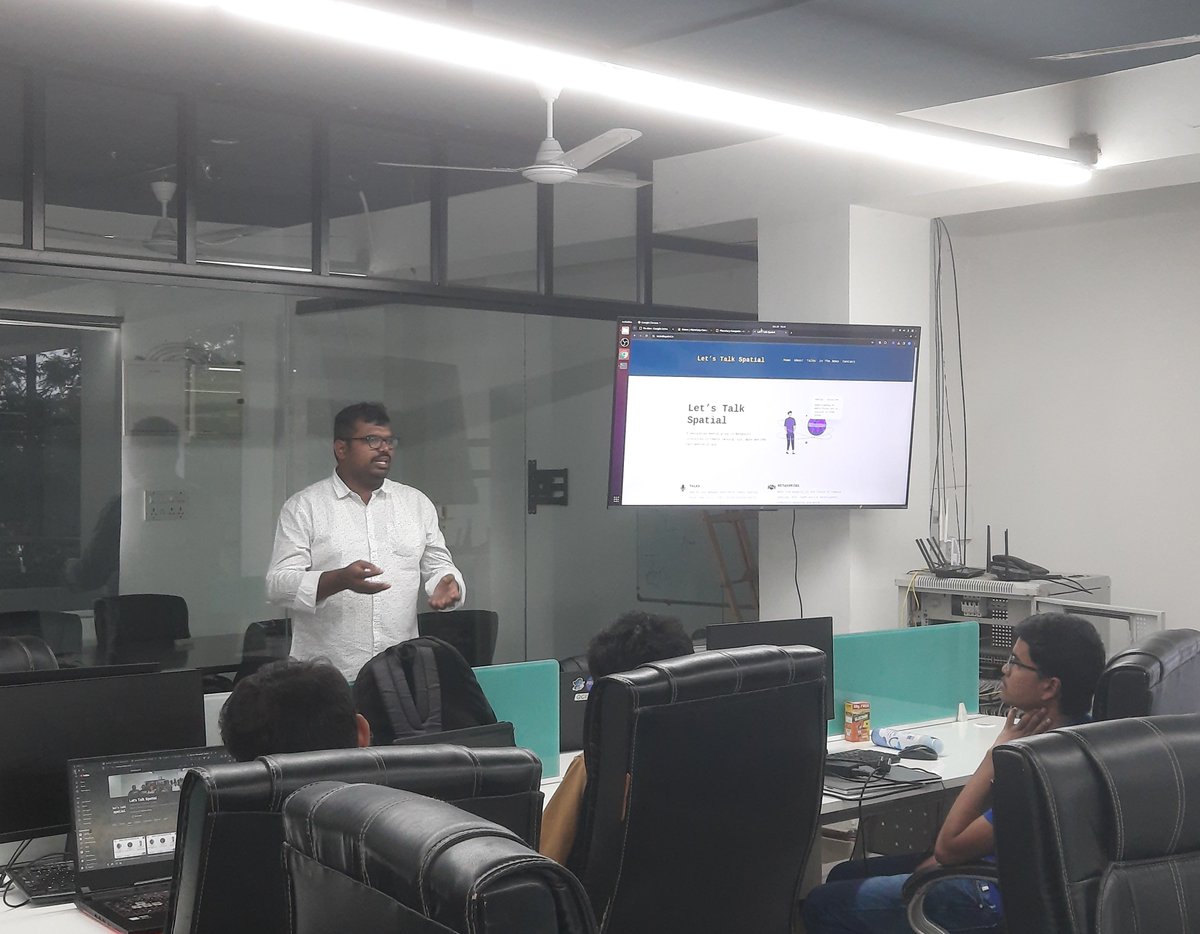
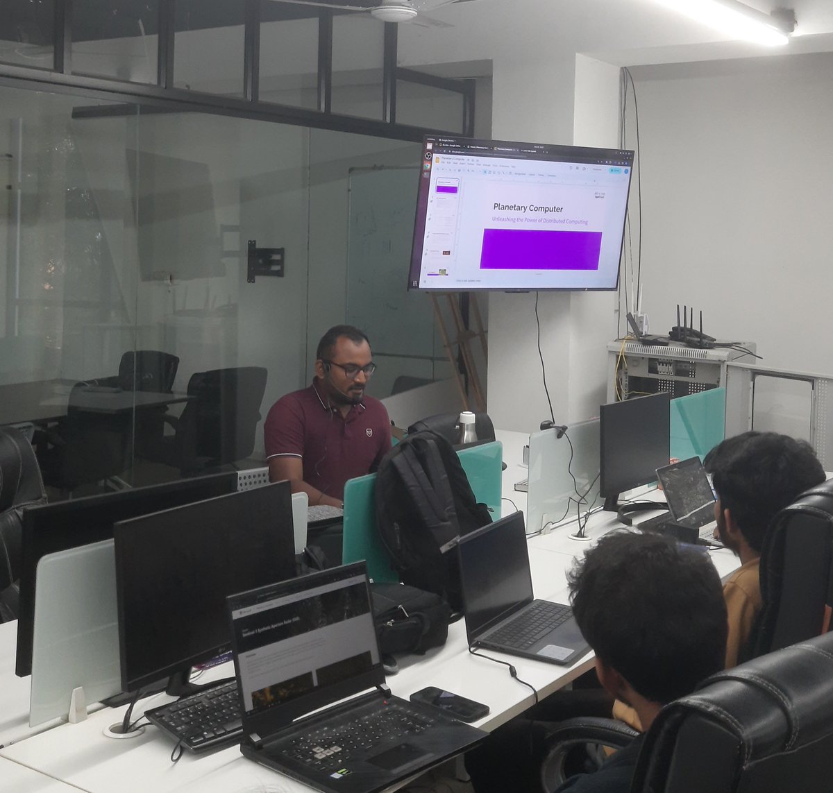
We had our 12th meetup today, exploring the intricacies of @STACspec and Microsoft’s #PlanetaryComputer . With comprehensive examples and a deep dive into the specification, we aimed to empower professionals and enthusiasts alike in leveraging these powerful tools.
1
5
7
1,858

29 Oct 2023
Starting Now!
Introduction to #planetarycomputer and #stacapi (@STACspec) by @letstalkspatial
Join us on YouTube live below: youtube.com/live/lUMjcau7JAs…
This event is jointly organised by @ieeegrss_blr and @letstalkspatial hosted at @satyukt

4
24
1,894

14 Sep 2023
In that case, it should probably be the role of @awscloud via their open data program to index all their static @STACspec catalogs and provide search capabilities on top, eventually via earth-search right?
Same for @microsoft #PlanetaryComputer and @googleearth #EarthEngine
1
2
87

2 Jul 2023
Are YOU interested in learning more about the major #EO cloud platforms? 🤔 Then check out the following @MindsBehindMaps episodes:
#7: #PlanetaryComputer
#12: #EarthEngine
#42: @Sentinel_hub
#44: Earth on @AWScloud
1 Jun 2023

Here's my conversation with @jedsundwall.
We talk about his work creating AWS's Open Data Registry, building open data programs that people actually use, what's new for @OurRadiantEarth and what Large Language Models like ChatGPT mean for Open Data policies
(Link in thread)
1
5
15
4,574
2 Jul 2023
Today I'm catching up on back episodes of @MindsBehindMaps and I'm finding the early episode w/ Dr. @BrunoSan (formerly of the #PlanetaryComputer team) an insightful entertaining listen.
The biggest 🤯 moment [for me] was Bruno's elaborating on "knowledge vs. skills." #EOchat
2 Oct 2021

Ep 7 is out!
My guest is @brunosan: we talk about his book "Impact Science", Education, entering Data Science & his work at @Microsoft on the Planetary Computer
Google Podcast: tinyurl.com/u8ybsw
Spotify: tinyurl.com/333smjhv
Apple Podcast: tinyurl.com/366jv65b
1
3
6
3,078

25 May 2023
If you haven't read our blog from @petegadomski focused on the components of Microsoft's #PlanetaryComputer and how it connects with STAC, what are you waiting for?
Check it out! ⬇️
10 May 2023

@Microsoft's #PlanetaryComputer is built on the @STACspec and the open system of tools around that specification. Read Pete's latest blog to learn more about Planetary Computer's various components, how MS uses #STAC & how this work benefits the larger community
#geospatial👇🏽
1
424

10 May 2023
@Microsoft's #PlanetaryComputer is built on the @STACspec and the open system of tools around that specification. Read Pete's latest blog to learn more about Planetary Computer's various components, how MS uses #STAC & how this work benefits the larger community
#geospatial👇🏽
9 May 2023

I gave a talk about on the Planetary Computer @STACspec at PECORA last December, and the companion blog post just got published: element84.com/blog/how-micro…
3
8
1,022
9 May 2023
🚨New blog alert! 🚨
In our latest post, we're covering:
- The components of the #PlanetaryComputer
- Demonstrating how it's based on both #cloud-optimized formats & the @STACspec
- & Discussing how this work benefits the larger community
Learn more: element84.com/blog/how-micro…
7
11
1,210

9 May 2023
In partnership with @Vizzuality and with support from @Microsoft, we're excited to share this new dataset on Biodiversity Intactness using IO's global land cover data with @NHM_London PREDICTS data. You can learn more at the link below, or see the data on #PlanetaryComputer
9 May 2023

Newly released on the @Microsoft #PlanetaryComputer:
Vizzuality & @ImpactObserv's new high resolution spatial models on biodiversity intactness combining @NHM_London #PREDICTS data, @esa @CopernicusEU imagery, & other data.
Find out more: bit.ly/3nQ9EKq
1
3
200

9 May 2023
Newly released on the @Microsoft #PlanetaryComputer:
Vizzuality & @ImpactObserv's new high resolution spatial models on biodiversity intactness combining @NHM_London #PREDICTS data, @esa @CopernicusEU imagery, & other data.
Find out more: bit.ly/3nQ9EKq
4
8
593

18 Apr 2023
Esri and @Microsoft empower scientists and researchers to observe and monitor our planet through Microsoft PlanetaryComputer , a massive catalog of global environmental data available to #ArcGISPro users. ow.ly/m8EZ50NJrR5 #EsriPartner

10
1,237

17 Apr 2023
Esri and @Microsoft empower scientists and researchers to observe and monitor our planet through Microsoft PlanetaryComputer , a massive catalog of global environmental data available to #ArcGISPro users. ow.ly/P1FJ50NKLkA #EsriPartner

9
43
2,632

10 Apr 2023
Esri and @Microsoft empower geographers, data scientists, and researchers to observe and monitor our planet through Microsoft PlanetaryComputer — a massive catalog of global environmental data available to #ArcGISPro users. #EsriPartner
Learn more 👇
esri.social/TR5K50NF6fM
7
20
1,481

21 Mar 2023
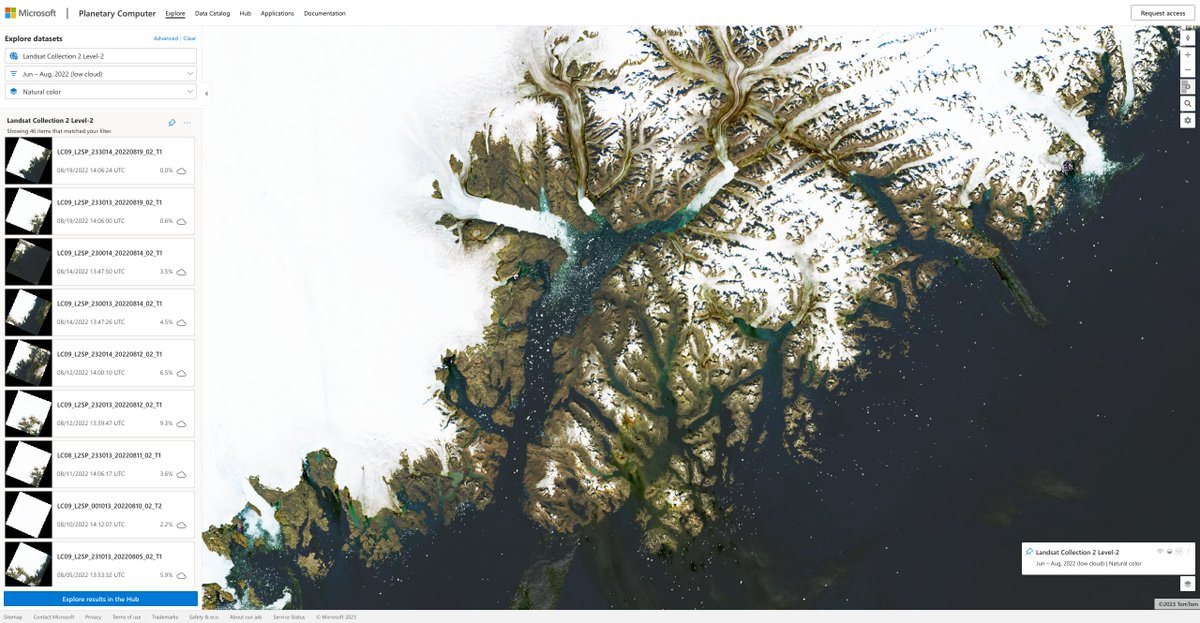
#PlanetaryComputer users can use a #QGIS instance directly in the Hub. We offer an experimental Linux desktop image that is preloaded with QGIS and is located in the same data center that the Planetary Computer datasets and APIs are hosted in
planetarycomputer.microsoft.…
10
43
4,052

3 Mar 2023
Yes! With #cubo you can use any collection from a @STACspec catalog as long as it is @cogeotiff 😉
Here is an example with @USGSLandsat 8 Collection 2 Level 2 from the @Microsoft's #PlanetaryComputer endpoint 🚀
#RemoteSensing #EOchat #GISchat #GeoPython #DataViz
1
12
20
3,209
3 Feb 2023
#Leafmap v0.16.0 has been released. It supports searching and visualizing open #geospatial datasets interactively from public #STAC API endpoint (e.g., #AWS, #PlanetaryComputer). Search results can be returned as a GeoDataFrame, list, dict.
Notebook: leafmap.org/notebooks/64_sta…
2
101
367
48,177