
📢{duckspatial} v0.9.0 is now on CRAN !! 🚀 If you work with big spatial data in #rstats, duckspatial brings the power of @duckdb to spatial analysis in R. It is dozenz
- 📦website cidree.github.io/duckspatial…
- Blog post: adrian-cidre.com/posts/014_d…
#duckspatial #rspatial
1
2
11
598
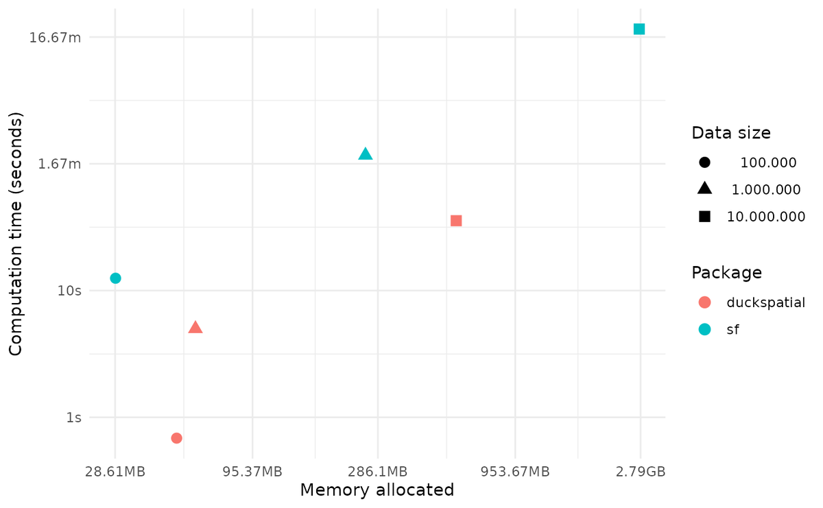
In a benchmark performing a spatial join between 10 million points and 257 polygons, {duckspatial} was 9x faster and used 5x less RAM than {sf}.
#duckspatial is bringging the power of #duckdb to #rspatial
2
395

28 Dec 2025
impressionante que tudo que é pra python tem uma aura de picaretagem e lero lero
jamais serão #rspatial
1
3
279

26 Nov 2025
Learning Resources 📚
Big shoutout to @milosmakesmaps for the excellent tutorial that guided this workflow!
YouTube: youtube.com/watch?v=k7xWK4rp…
His #rspatial tutorials are 🔥 for anyone wanting to level up their cartography game!
1
2
264

14 Nov 2025
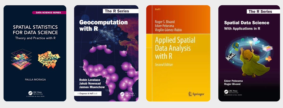
🎉 Top Libros de Análisis Espacial con R (con acceso online gratuito) 🗺️
Si trabajas con SIG y quieres potenciar tus habilidades de análisis de datos geoespaciales, R es una excelente opción.
#rstats #datascience #rspatial #analytics #AnalisisEspacial #GIS #SIG #Geoespacial
6
112
426
13,222

12 Nov 2025
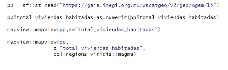
#30DayMapChallenge
'10 minutes map' Viviendas habitadas por municipio.
Mapa en 4 líneas de código.
Desde @INEGI_INFORMA puedes leer cualquier geometría con datos de población y vivienda a nivel Ent, Mun y Ageb, así como sus vialidades
noeosorio-pk.quarto.pub/mapa…
#Rspatial #rstats
2
298
12 Nov 2025
#30DayMapChallenge
Día 11 Minimalista Matrices de contigüidad municipal por Estado.
Mi favorito el 28 (Tamaulipas), parece un elefante y el 25 un papalote. #Rstats #Rspatial
Código: github.com/useReconomist/30D…

1
2
7
623
12 Nov 2025
Añade un minimapa de navegación con addMiniMap() al trabajar con mapas interactivos.
👉 ¿Has usado leaflet o sf en tus proyectos?
#DataScience #RSpatial #DataVisualization #GeospatialAnalysis #Epidemiología #OpenData


1
1
7
727
11 Nov 2025
👇 Quiero hacer esto en #RStats 🤩
¿Alguien sabe cómo?
#Help #SOS #DataScience #Leaflet #GIS #RSpatial #DataVisualization #GeospatialAnalysis #Epidemiología #OpenData #30DayMapChallenge

#30DayMapChallenge Day 10 — Air
Today’s striking air-quality map from @ClimateTRACE visualizes PM2.5 pollution plumes from thousands of industrial sources around the world. The underlying data show how more than 1.6 billion people live within 10 km of these emissions-intensive facilities.
Explore the map here: climatetrace.org/air-polluti…
#BuiltWithMapbox #AirQuality #EnvironmentalData
2
15
99
6,741


R Consortium ISC Grant Applications are OPEN w/a deadline of Oct. 1st! Get funded to contribute to the 🐇 R ecosystem.
At Esri, we're a proud member of the R Consortium and the ISC's Grant program has been pivotal in growing the Rspatial ecosystem.
esri.com/arcgis-blog/product…
1
4
267

1 Aug 2025
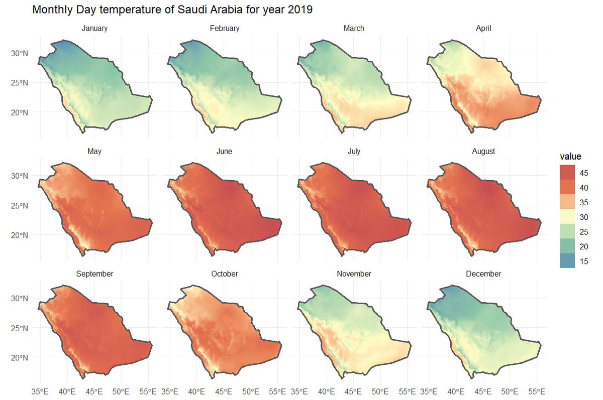
#Thread (Mini) So Last year I crafted another climateR🌤️🌧️ tutorial using R programming which In this tutorial I've tried to make a shinyapp which non coders could use to quickly visualize annual map #gischat #cartography #GIS #climate #geospatial #dataviz #R #rspatial
20 Mar 2024

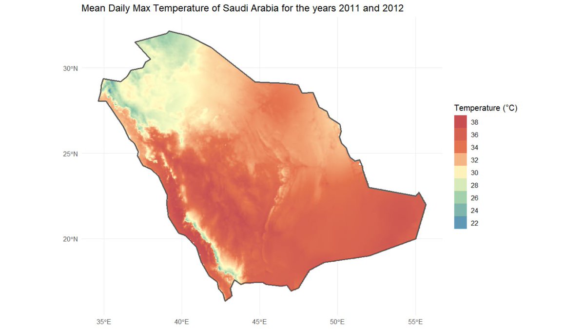
#Thread [Update] So Last year I crafted a climateR🌤️🌧️ tutorial using R programming which In this tutorial I'm still going to use The Kingdom of Saudi Arabia 🇸🇦 and one of It's Province, I'll share GitHub link (1/4) #gischat #cartography #GIS #geospatial #dataviz #R #rspatial

1
13
59
7,725
{r5r} good news: now it's possible to adjust car speeds in #r5rstats to simulate different scenarios of traffic congestion and road closures. This feature is available in the dev version and will be included in the next release:
ipeagit.github.io/r5r/dev/ar… #rstats #rspatial #r5rstats
33
162
12,524

23 Jun 2025
TOMORROW! Scaling the r-spatial ecosystem for the modern composable data pipeline - with Dewey Dunnington, Senior Software Engineer at Wherobots
Tues, June 24, 1pm ET
Sign up now! r-consortium.org/webinars/sc…
#RStats #rspatial #OpenSource @paleolimbot @wherobots

3
7
567
1 May 2025
Amigos, impartiré un curso en línea de 'R para análisis espacial y datos ( espacial)' Va a estar genial, si quieres más información mándame un DM o regístrate en este link, igual anda el temario ahí.
forms.gle/TLbRAyznEUjmFYnX7
#RStats #Rspatial #maps
inicia el 12 de mayo :)
16
52
303
22,043


21 Feb 2025
Actualización de Infografía de Grandes Incendios Forestales en España con datos de 2010 a 2023. Código disponible en github.com/dieghernan/gifs #rstats #rspatial
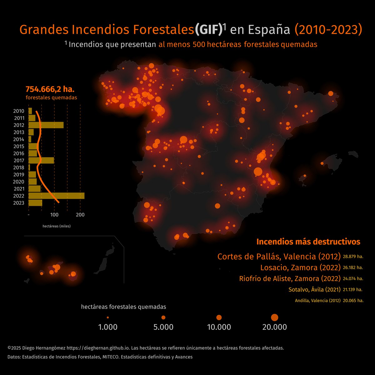
ALT Infographics depicting largest forest fires in Spain in the period 2010-2023, including a map an several additional statistics as the surface burnt by year and the top 5 largest single fires recorded
25 Mar 2022

Mi primera infografía con #rstates Grandes Incendios Forestales en España (2010-2020) con datos del @mitecogob cc: @IncendiosES #rspatial #iiff #IncendiosForestales
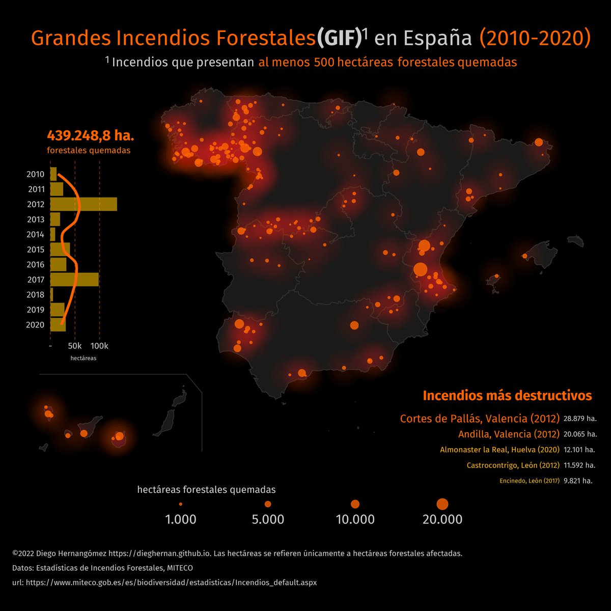
ALT Mapa con la distribución de grandes incendios forestales (más de 500 hectáreas afectadas) en España en la última década
1
1
10
475

4 Feb 2025
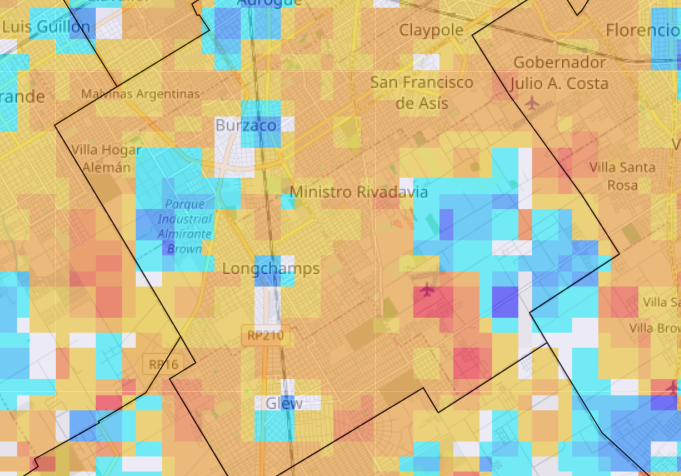
#30DayMapChallenge Day 16 - Choropleth
Interactive map of median household income distribution in Hong Kong, made with #RStats
Challenging myself to create a non-static and non-QGIS map, despite a late submission 🤐
#RSpatial
19
114
6,501

19 Jan 2025
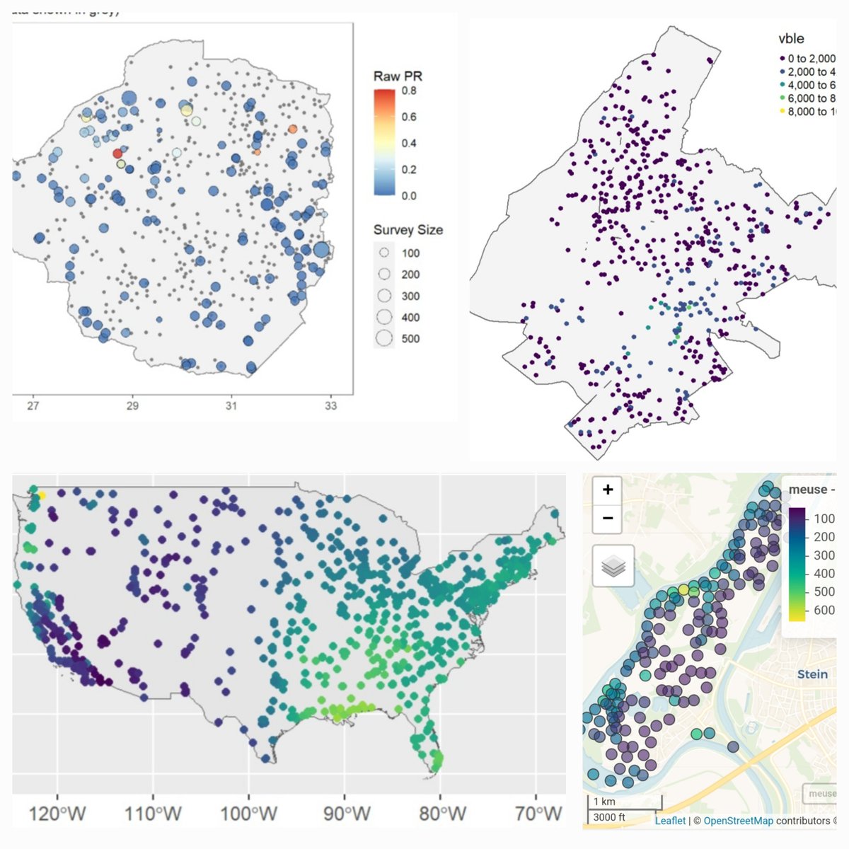
Spatial prediction methods for geostatistical data such as disease prevalence 🪰, precipitation 🌧️, contaminants 🏭, household prices 🏡
🔗paulamoraga.com/book-spatial…
#rstats #rspatial #GISChat
115
495
24,547
8 Jan 2025
🗺️ Making maps with R 🗺️
Examples of static and interactive maps and mobility flows using {ggplot2}, {leaflet}, {mapview}, {tmap} & {flowmapblue}
👉 paulamoraga.com/book-spatial…
#rstats #rspatial #GISchat #datascience
76
290
13,361