
🚌📍 Never miss your bus again!
With *TGSRTC Gamyam*, track buses in real time, discover nearby bus stops, and plan your journey effortlessly. Travel smart, faster, and with greater convenience.
#TGSRTC #Gamyam #SmartMobility #TrackYourBus #RealTimeUpdates #TravelSmart

4
7
521

Jun 9
Stay ahead with real-time updates on the new BAANKNET app.
Get instant alerts for:
✔ New property listings
✔ Bid updates
✔ Auction reminders
✔ Property status changes
Never miss your dream property’s auction.
#BAANKNET #PropertyAuction #RealTimeUpdates #PSBAlliance

22

Jun 5
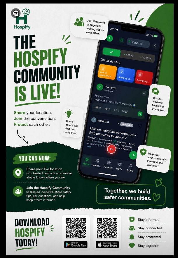
One app. One network. Thousands of people helping each other stay informed when it matters most. 📲🌍
HospifyApp #CommunitySafety #StayConnected #SafetyFirst #RealTimeUpdates #EmergencyAlerts #LocationSharing #SaferCommunities
2
4
13

May 18
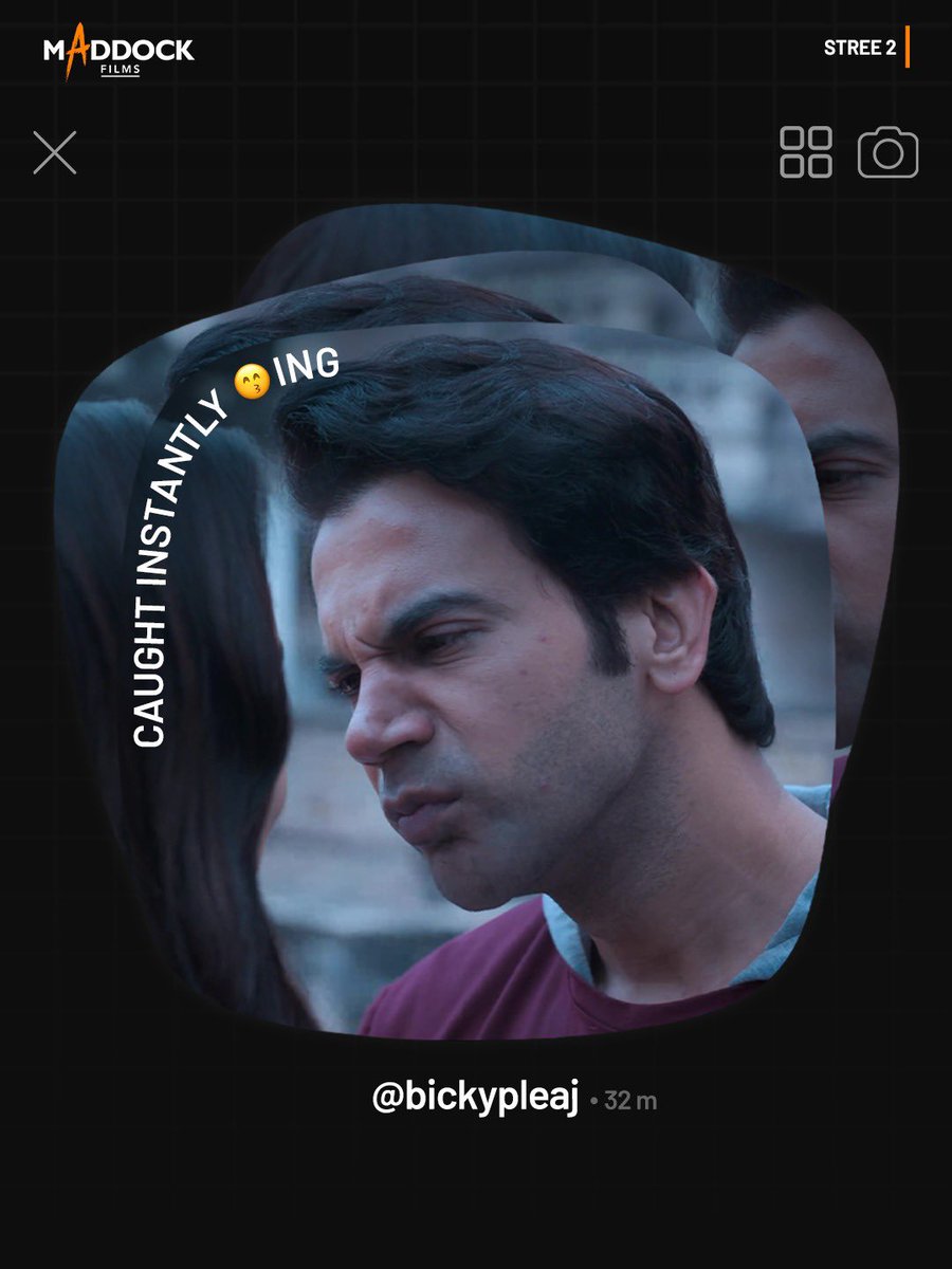
Instants pe kaand ho gaya 🐺
#Trending #Instants #Trend #InstantsFeature #RealTimeUpdates #Fun #Comedy #Stree2 #Cocktail #GoGoaGone #Bala #LukaChuppi #ZaraHatkeZaraBachke #Bhediya #ParamSundari #DineshVijan #MaddockFilms


1
2
41
2,187

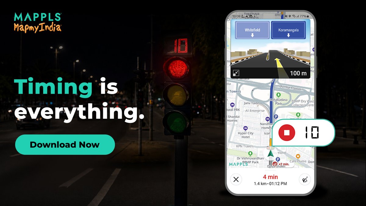
Are you even driving in India if you’re not stuck at a random signal?
With the Mappls App, at least you’ll see it coming.
Live signal timers and real-time alerts, so you’re always one step ahead.
Kyunki samay wapas nahi aata ⏳
Download the Mappls App now: mappls.com/getapp
@rakeshverma1950 | @RashmiNext | @_rohanverma
#Mappls #MapmyIndia #LiveTraffic #TrafficUpdates #SmartNavigation #DriveSmart #RealTimeUpdates #NavigationApp #TrafficAlert
4
23
537
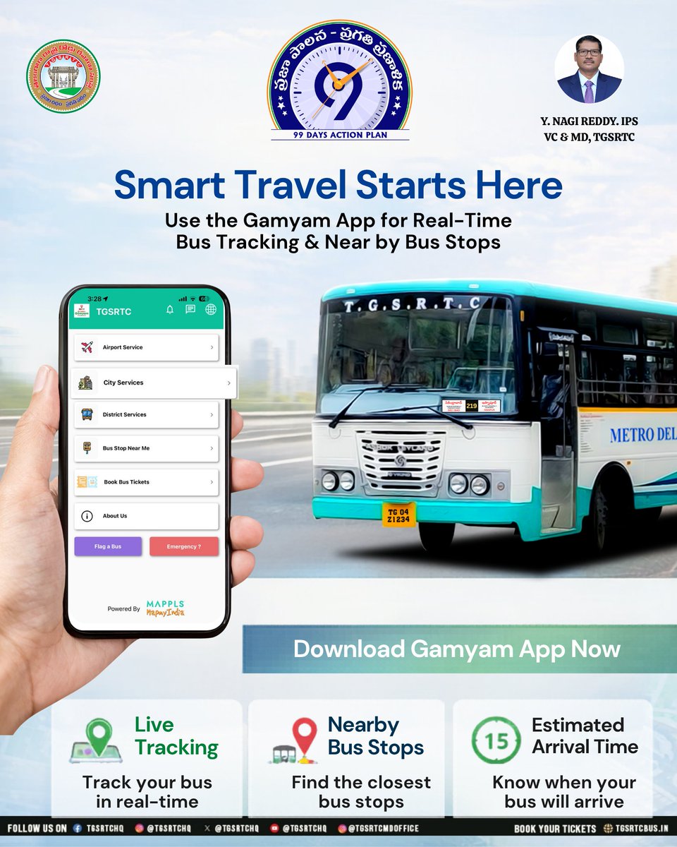
Smart travel begins with smarter choices! 🚌📱
Track your bus live, find nearby stops, and never miss your ride with the Gamyam App.
Your journey, now in real-time!
#TGSRTC #GamyamApp #SmartTravel #LiveTracking #PublicTransport #CityCommute #DigitalIndia #RealTimeUpdates
6
6
15
985

अब हर अपडेट पाएं सबसे तेज़! UPPCL के X हैंडल से जुड़ें और रहें हर जानकारी से अपडेट।
Follow करें: : x.com/UPPCLLKO
#UPPCL #TwitterX #RealTimeUpdates
@CMOfficeUP
@EMofficeUP
@aksharmaBharat
@mduppcl

40
7
20
3,017


Apr 6
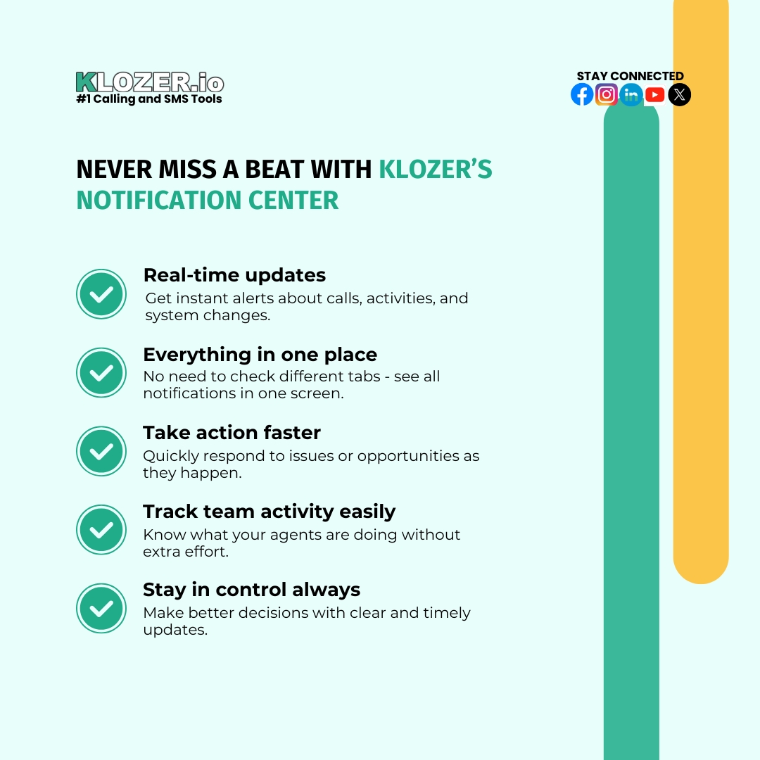
Never miss what matters.
With 𝐊𝐥𝐨𝐳𝐞𝐫’𝐬 𝐍𝐨𝐭𝐢𝐟𝐢𝐜𝐚𝐭𝐢𝐨𝐧 𝐂𝐞𝐧𝐭𝐞𝐫, you get real-time updates, clear visibility, and everything in one place - so you can act faster and stay in control at all times.
#Klozer #CallCenter #SalesTools #Dialer #RealTimeUpdates
17
17
149

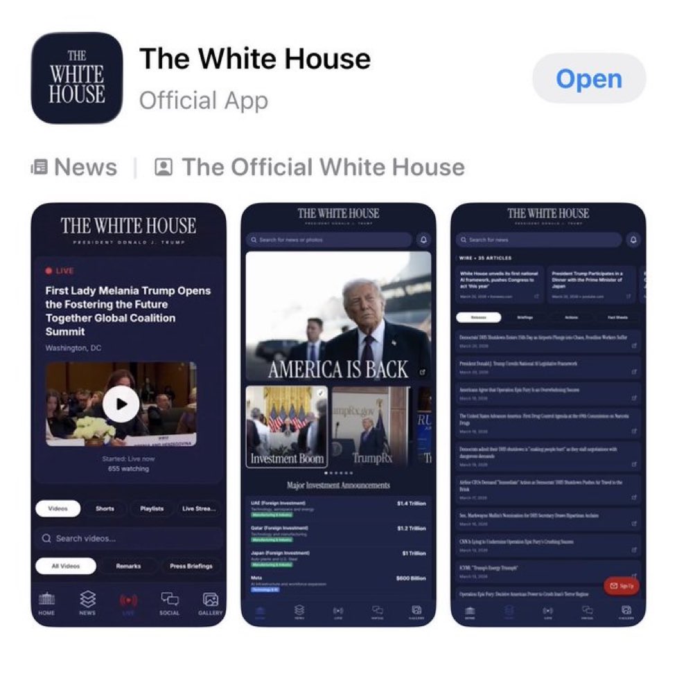
🚨 WHITE HOUSE LAUNCHES OFFICIAL APP FOR REAL-TIME UPDATES
#WhiteHouse #BreakingNews #AppLaunch #RealTimeUpdates
1
5
280

Check out the must-see talk by Kristopher Baumgartner on optimizing React apps for real-time updates at 120fps. #React #RealTimeUpdates
gitnation.com/contents/react…

2
222

Feb 16
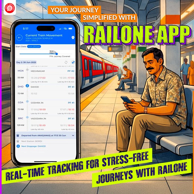
Running late? Or just curious? 👀
Track your train in real-time with RailOne App.
Travel smart. Travel stress-free.
#RailOne #TrainTracking #SmartTravel #DigitalRailways #RealTimeUpdates #StressFreeTravel #indianrailways
👉 Download the RailOne App now👇
play.google.com/store/apps/d…
2
81

With the Spring & Summer sports season approaching, we are ready to help you raise funds for your Programs more efficiently than ever.
Our platform offers a variety of high-impact fundraiser options!
#OneHourEvents
#TeamBuilder
#LifeSkills
#PlayerAccounts
#RealTimeUpdates

1
5
120

🚨California: 98 Earthquakes In 24 Hours | Major Fault Zone
Southern California’s live USGS map is showing 98 earthquakes in the last 24 hours in the region I am tracking, with many of those tiny tremors lining up along major fault trends. On the surface, 98 sounds extreme, but this is where the deeper story starts.
USGS estimates that Southern California averages around 10,000 earthquakes every year. That is roughly 25–30 quakes per day on average, and most of them are so small that nobody feels them. They exist only on seismograph screens. With better instruments and new detection methods, scientists have found that there are actually far more microquakes than the older catalogs ever showed. That means seeing dozens or even close to a hundred tiny events in one 24 hour window is not automatically a sign that “the Big One” is about to hit, but it is absolutely a sign that the fault network is active and slipping right now.
At the same time, this is not some random calm area. Southern California sits on a tangled plate boundary that includes the San Andreas, San Jacinto and many other faults capable of producing magnitude 7 and 8 earthquakes. History has already delivered events like the 1971 San Fernando, 1994 Northridge, 1992 Landers and 2019 Ridgecrest sequences. Those were all preceded by “just small quakes” on maps that looked a lot like today’s, until one of them suddenly was not small anymore.
I am monitoring the same USGS and Caltech feeds seismologists use, in real time. If this turns into a swarm, if we see a stronger mainshock, or if any official statements change, I will break it down for you within minutes, not days.
#california #southerncalifornia #californiaearthquake #earthquake #earthquakes #earthquakeupdate #24hours #explore #viralvideos #sanandreas #faultline #seismicactivity #seismic #usgs #ringoffire #naturaldisaster #disasterwatch #preparedness #californianews #losangeles #sandiego #tectonic #plateboundary #realdata #realtimeupdates #breakingnews #worldnews #fyp #viralreels #divyafindsyou
5
17
1,271

Jan 15
What’s the latest on Iran right now?
Protests escalating, reported crackdowns, airspace closures, Trump statements on executions & potential US action, events moving fast.
Text Ping AI for instant real-time updates: “Latest news on Iran” or “Summarize Iran protests today”
Get clear, up-to-date info straight to your phone — no app, no scrolling.
Tap here → go.textping.ai/text
#PingAI #IranNews #RealTimeUpdates #TextAI
What’s your go-to question for breaking news? 👇
1
1
1
148


9 Dec 2025
Day 124 – Full Blocking System Rebuild, Privacy Compliance & New App Store Submission 🚀
🔹 Rebuilt the Entire Blocking System (Fully Compliant Bidirectional)
Resolved every issue raised in the latest App Store rejection.
Previously, blocking worked only on the HomeScreen and only one-way →
If User A blocked User B, B could still see A’s memes and profile.
This inconsistency was a major privacy concern.
Now the blocking system is fully rebuilt to work like a standard, platform-compliant block flow:✔ Bidirectional Blocking:
If A blocks B → B also loses access to all of A’s content.✔ New BlockService:
Manages both:
“Users I blocked”
“Users who blocked me”
Ensures all logic stays consistent across the app.✔ Real-Time Privacy Enforcement Across Modules:
DiscoveryProvider: Filters out blocked users instantly.
MessagesProvider: Removes blocked users from message lists in real time.
ChatService: Prevents sending or receiving messages with blocked users.
UserService: Blocks profile access completely, even through deep links or cached navigation.The entire app now behaves as a fully privacy-compliant system, matching App Store expectations.
🔹 New App Store Build Submitted
After implementing all changes and validating the flow across Android and iOS devices, submitted a new build to the App Store.
Now awaiting review.
#MemeMates #FlutterDev #AppStoreReview #PrivacyCompliance #BlockingSystem #MobileAppSecurity #StateManagement #BuildingInPublic #StartupLife #TechFounder #CleanArchitecture #RealTimeUpdates #AppDevelopment #IndiaStartups #DailyProgress #UXImprovements #ChatService #ProductUpdate
1
3
53

28 Nov 2025
#WATCH गुजरात: i-Pragati ने बदल दी पुलिस से जुड़ी जानकारी पाने की प्रक्रिया।
#IPragati #GujaratPolice #RealTimeUpdates #FIRTracking #SmartPolicing #CitizenFriendly #TechForGood #BhupendraPatel #TransparentPolicing #GrievanceRedressal
1
6
1,570
#WATCH | I Pragati: Gujarat’s new system for real-time police case updates
#IPragati #GujaratPolice #RealTimeUpdates #FIRTracking #SmartPolicing #CitizenFriendly #TechForGood #BhupendraPatel #TransparentPolicing #GrievanceRedressal
1
3
21
8,623