
3 Dec 2025
12/2(火) に急遽開催した東南アジア各地での洪水対応のクライシスマッピングイベント Humanitarian Mapathon のレクチャー動画を YouTube に公開しました。興味はあったけど、時間が合わなかった方、建物1軒でもかまいませんので、ぜひご協力いただければ幸いです! 対象のプロジェクトURLはコメント欄に貼ります。
youtu.be/hrp2PDo1Ngk
#Flood #CrisisMapping #HOTOSM #麗澤大学 #青学 #QMP #UNMappers #UNOpenGIS #SmartMaps #CrisisMappersJapan #DRONEBIRD #FuruhashiLab #古橋研究室 #AoyamaGSC #地球社会共生学部
1
4
7
2,108
2 Dec 2025
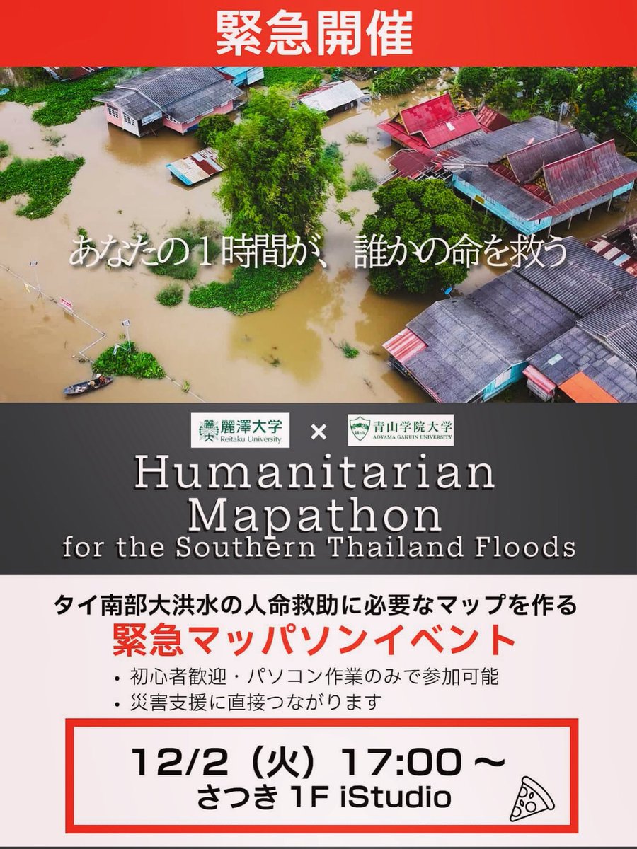
本日(12/2)17:00 JST 〜、リアル&オンラインのハイブリッドで東南アジア各地での豪雨・洪水クライシスマッピング Mapathon を麗澤大学と青学合同で開催します。初心者向けにレクチャーもやります。興味のある方大歓迎です。
zoom.us/j/91064385064?pwd=t2…
#CrisisMapping #HOTOSM #QMP #UNMappers #UNOpenGIS #SmartMaps #CrisisMappersJapan #DRONEBIRD #FuruhashiLab #古橋研究室 #AoyamaGSC #地球社会共生学部 #青学
6
6
2,222
1 Dec 2025
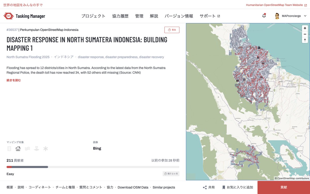
インドネシア北スマトラでも洪水が発生しています。今年はどうなっているのか、いつも以上に世界各地での災害報告がやってきています。
今回の洪水は北スマトラ州の12の地区・都市に広がっています。北スマトラ地方警察の最新データによると、死者は34人に達し、52人が依然として行方不明となっているとのこと。
タイ・スリランカ・インドネシアの他、ジャマイカでもハリケーン被害が報告されています。引き続きのマッピング支援よろしくお願いいたします。
Disaster Response in North Sumatera Indonesia: Building Mapping 1 | HOT Tasking Manager
tasks.hotosm.org/projects/36…
#Indonesia #Flood #CrisisMapping #HOTOSM #QMP #UNMappers #UNOpenGIS #SmartMaps #CrisisMappersJapan #DRONEBIRD #FuruhashiLab #古橋研究室 #AoyamaGSC #地球社会共生学部 #青学
3
10
1,850
30 Nov 2025
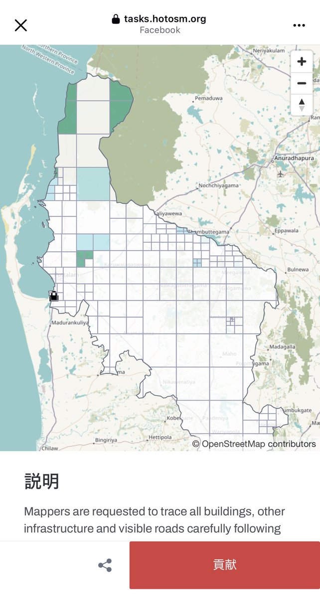
スリランカでもサイクロンDITWAHの影響による洪水被害が広がっています。あちこち大変な状況ですが、こちらのクライシスマッピングもご支援どうぞよろしくお願いいたします!
tasks.hotosm.org/projects/36…
#SriLanka #Flood #CrisisMapping #HOTOSM #QMP #UNMappers #UNOpenGIS #SmartMaps #CrisisMappersJapan #DRONEBIRD #FuruhashiLab #古橋研究室 #AoyamaGSC #地球社会共生学部 #青学
1
6
884
29 Nov 2025
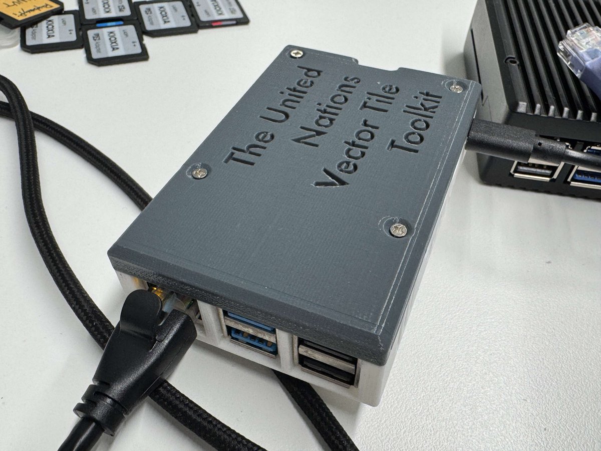
FOSS4G SHINSHU 2025 での発表資料を公開しました!
#UNVTportable #UNOpenGIS #SmartMaps #FOSS4G #foss4gj #RaspberryPi #FuruhashiLab #古橋研究室
完全オフライン地図サーバ UNVT Portable を フィールドに持っていこう!
speakerdeck.com/mapconcierge…

6
27
2,192
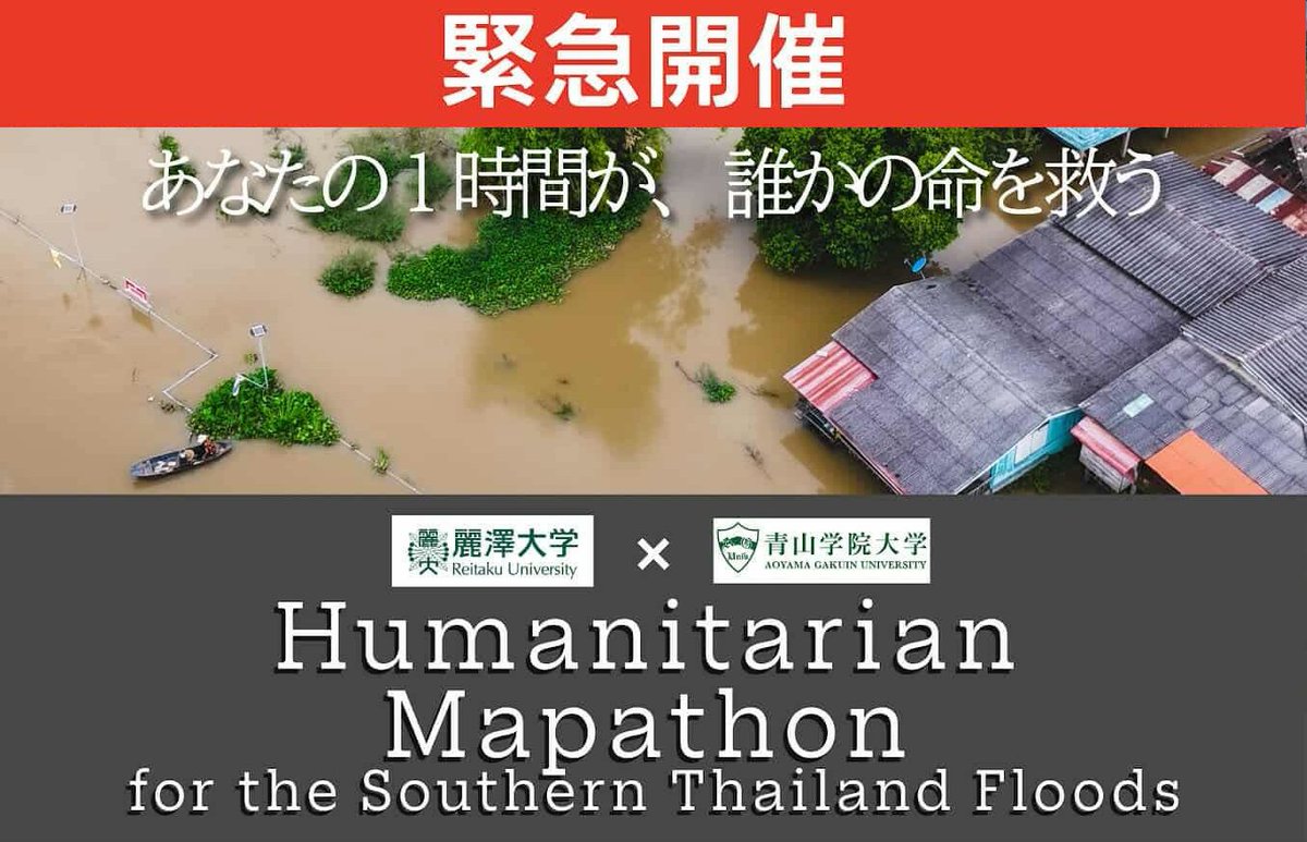
28 Nov 2025
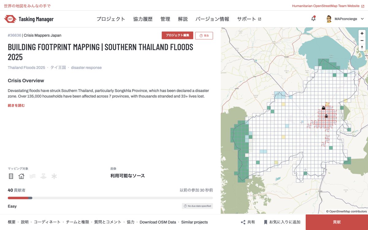
壊滅的な洪水がタイ南部を襲い、特にソンクラー県(Songkhla)は災害地域に指定されました。7県にまたがる13万5000世帯以上が被災し、数千人が孤立し、33人以上が亡くなりました。FOSS4G Thailand メンバーの Pongsakorn Udombua 氏から緊急のクライシスマッピング依頼があり、UN OpenGIS Initiative の Smart Maps チーム 藤村 英範 さんと連携して、急遽 HOT Tasking Manager にて建物・道路マッピングプロジェクト立ち上げ支援を行いました。確かに、このエリアはまだまだ建物マッピングが進んでおらず、多くのボランティアマッパーのサポートが必要です。ぜひご支援いただければ幸いです。
tasks.hotosm.org/projects/36…
#Thailand #Songkhla #Flood #CrisisMapping #HOTOSM #QMP #UNMappers #UNOpenGIS #SmartMaps #CrisisMappersJapan #DRONEBIRD #FuruhashiLab #古橋研究室 #AoyamaGSC #地球社会共生学部 #青学
7
15
2,683

27 Jul 2025
2/2
📍Life2App isn’t just a map — it’s a lifestyle layer.
• Get rewarded for daily actions
• Find smarter places
• Help improve maps
• Let businesses find you through movement
It’s not clicks. It’s connection.
🌐 life2app.com
#SmartMaps #BNBChain #Web3Life
4
33
25 Jun 2025
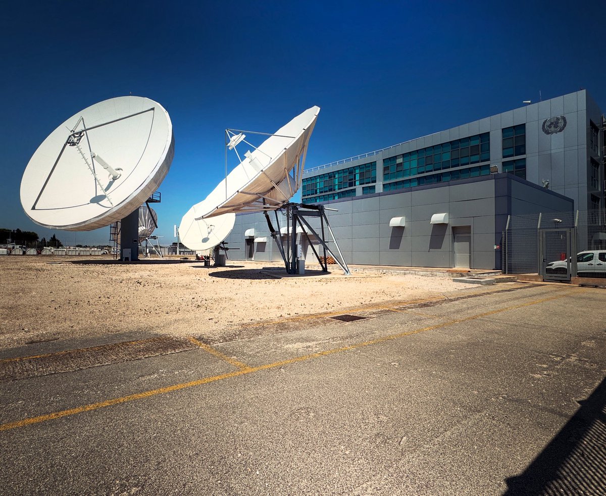
いつもプレゼンではよく見ていた国連 UN GSC の衛星通信用パラボナアンテナ群をリアルで観れた!!Brindisi Airport併設の施設なので空港降り立ったらすぐにお迎えに来てもらえました。
#UNGSC #UNMAPPERS #UNOpenGIS #UNVTportable #SmartMaps #FuruhashiLab #古橋研究室 #AoyamaGSC #青学 #GEOlab #PoliMI
1
14
505
25 Jun 2025
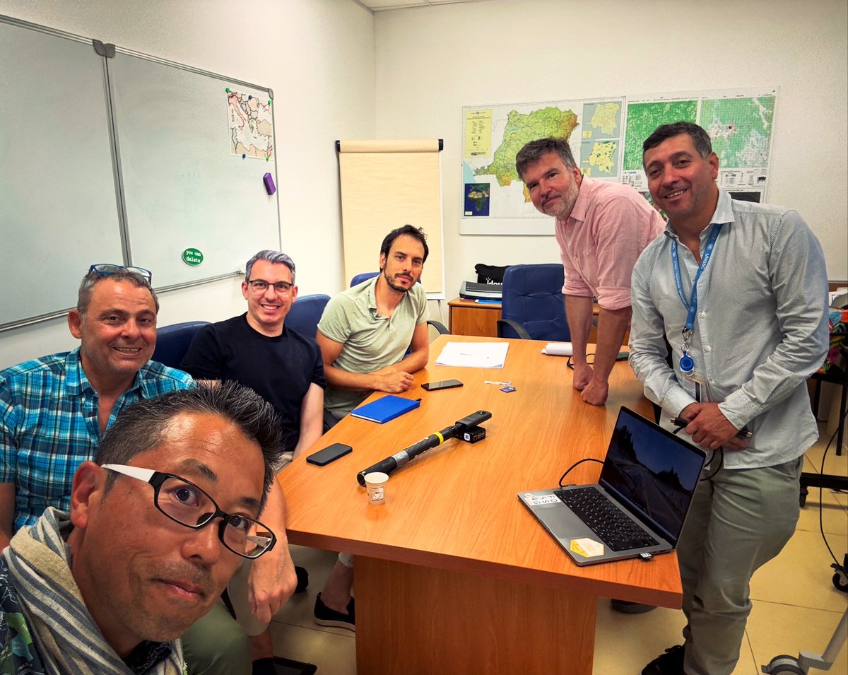
国連 UN GSC の地理空間情報チームとUNVT Portable を含めたこれからの国連業務での最先端技術の取り込みについて熱い議論。思いの外、THETA X によるストリートレベル画像の利活用が刺さって嬉しい。
#UNGSC #UNMAPPERS #UNOpenGIS #UNVTportable #SmartMaps #THETA360 #Mapillary #FuruhashiLab #古橋研究室 #AoyamaGSC #青学 #GEOlab #PoliMI
9
491

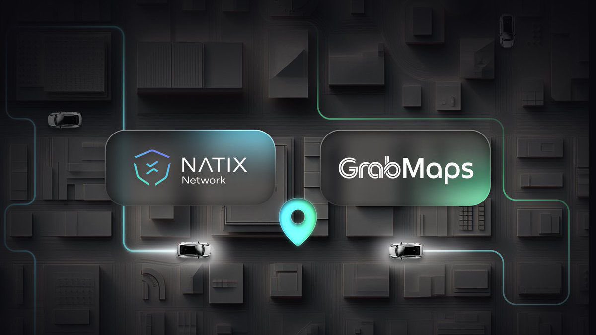
10 Jun 2025
🌍 Buckle up, tech explorers!
Picture a world where your city streets become a giant treasure hunt, powered by the coolest gadgets and brainy AI.
That’s exactly what’s happening when Grab teams up with NATIX the ultimate map-making duo! 🗺️🤝
Grab, a pioneer in crowdsourced street imagery, brings its top-tier cameras (including award-winning 360° marvels and Tesla plugins) and cutting-edge AI to the table.
Meanwhile, NATIX’s Internet of Cameras turns everyday street cameras into a global data goldmine, incentivizing drivers to share their footage via blockchain magic.
It’s like turning your daily commute into a revenue stream! 💸🚗
Together, they’re crafting the future of mobility think autonomous cars navigating seamlessly, maps that are smarter than ever, and a world where Physical AI is just the beginning.
Whether you’re a tech geek, a city dweller, or an adventurer, this partnership is a peek into the next-gen transportation revolution.
Stay tuned big things are rolling out soon! 🌐✨
#FutureOfMobility #SmartMaps
6 May 2025

📢 DEPIN MEETS SUPERIOR MAPPING TECHNOLOGY 📢
We’re excited to announce our collaboration with Grab, Southeast Asia’s leading super app, to reshape the mapping industry 🗺️
By joining forces, we’re making high-fidelity, freshly updated maps a global reality 💪
42
40
57
9,148

3 Jun 2025
4/ ⚠️ This is not financial advice. Always DYOR.
3DMapFi is for those building the next frontier of onchain intelligence.
Let’s map the future.
#3DMAPFI #Solana #AI #DePIN #Geospatial #Web3 #Crypto #ForwardDotFun #SmartMaps #LaunchDay
2
48

30 May 2025
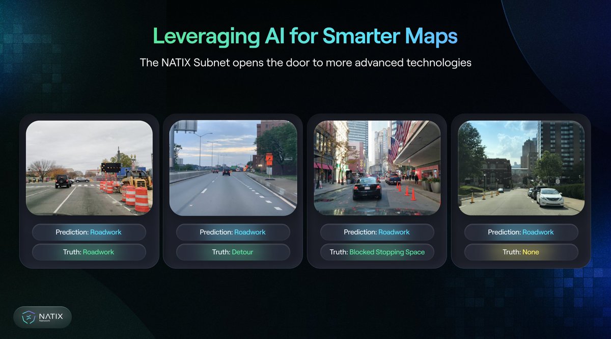
✨ What if every time you drove, you were helping make the world’s maps smarter, and getting rewarded for it?
That’s exactly what @NATIXNetwork is doing. They’re using the power of AI smartphones to create real-time, intelligent maps that update themselves as people drive. No fancy hardware. Just your phone.
📲 Using the Drive& app, your phone’s camera detects things like:
Traffic signs
Potholes
Road conditions
Accidents
...all anonymously and safely, with AI doing the work right from your device.
🌍 Instead of waiting months for maps to be updated, NATIX builds a living, breathing map powered by everyday people. It’s community-powered mapping that gets smarter every day.
And the best part?
You earn rewards (crypto) for simply driving and contributing useful data. So you're not just driving—you’re driving smarter, helping cities, and earning while at it.
This is what the future of mapping looks like—and it’s already here.
🔗 Dive in at natix.network
#AI #DriveToEarn #SmartMaps #NATIXNetwork
8
6
31
3,118

29 May 2025
🚨 BREAKING: @NATIXNetwork x Grab Partnership! 🚨
We’re thrilled to announce that NATIX Network has officially partnered with Grab — Southeast Asia’s $20B super app — in a game-changing move to revolutionize the future of AI-powered digital mapping. 🌍✨
🔍 Here’s what this means:
🚗 Grab joins as a key data partner, leveraging the power of NATIX’s VX360 platform to supercharge their geospatial capabilities — all powered by decentralized infrastructure.
🤖 More than just data — Grab is also stepping in as a tech collaborator, contributing cutting-edge AI tools and hardware to accelerate the development of real-time, intelligent maps.
💥 This partnership is a massive milestone — not just for us, but for the entire decentralized mapping movement.
We’re building the future — smarter, faster, and more open.
And this is only the beginning. 🌐
👉 Follow us to stay ahead of the curve.
#NATIX #Web3Mapping #AI #SmartMaps #Grab #GeospatialTech #DePIN
42
31
1,184
13 Mar 2025
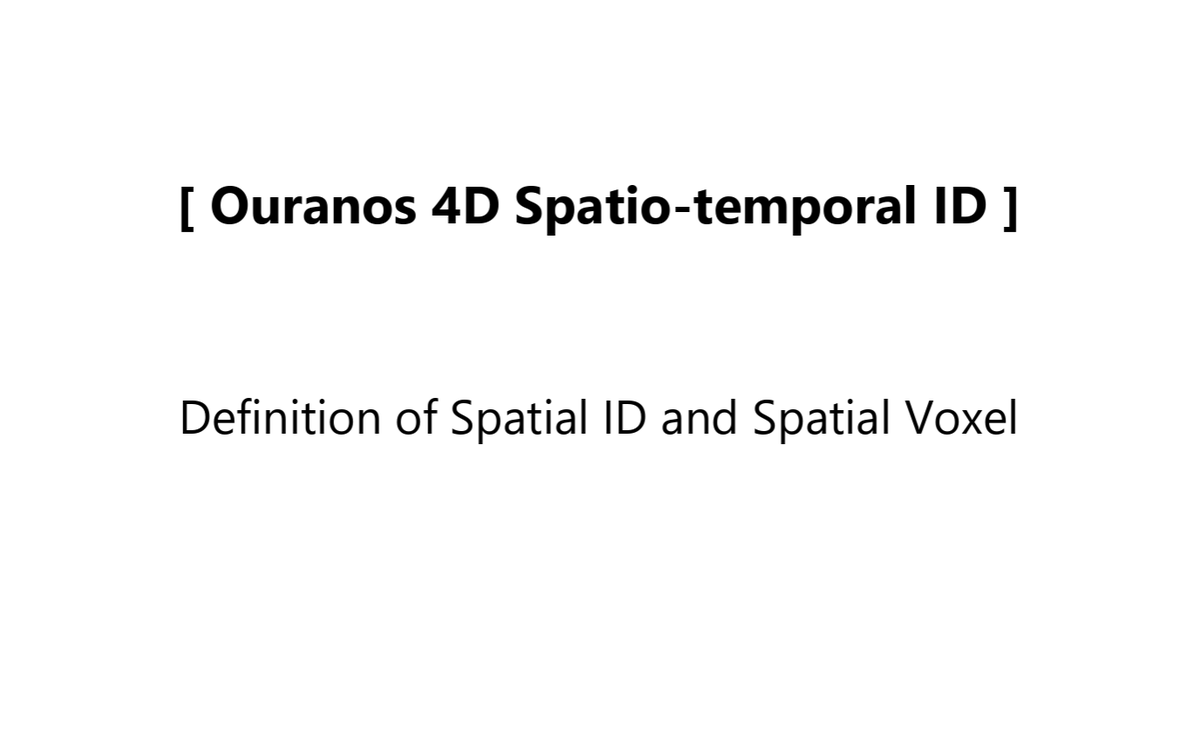
The Japanese government has been publishing the **3D Spatial ID Architecture Guidelines**, which enable the unique (non-overlapping) identification of specific spatial regions. Recently, the **English version** summarizing its overview and definitions has been released.
The official English name is **"Spatial ID and Spatial Voxel"**, but since this name is somewhat cumbersome as a proper noun, I personally refer to it as **"ZFXY Spatial ID"**, inspired by the **zfxy voxel** algorithm from the **UN OpenGIS Initiative**.
To implement **3D digital twins of cities** in society, it is essential to conceptualize **spatial IDs that define voxel regions in three-dimensional space with zoom level concepts**. I hope that this spatial ID will evolve into a **key infrastructure** supporting the distribution of geospatial information.
日本政府は、空間上の特定の領域を一意に(重複なく)識別するための3次元空間IDアーキテクチャガイドラインを公開してきました。このたび、その概要と定義をまとめた英語版が公開されました。
正式な英語名称は "Spatial ID and Spatial Voxel" ですが、この名称は固有名詞として扱いにくいため、アルゴリズムの基盤となっている UN OpenGIS Initiative の zfxy ボクセル にちなんで、個人的に 「ZFXY空間ID」 という愛称で呼ぶことにします。
都市の3次元デジタルツインを社会実装するためには、三次元空間におけるボクセル領域をズームレベルの概念を持つ空間IDとして定義できる発想が求められます。この空間IDが、地理空間情報の流通を支える重要なインフラとして発展していくことを期待しています。
* Definition of Spatial ID and Spatial Voxel:
ipa.go.jp/digital/architectu…
* zfxy-spec: ZFXY specifications
github.com/unvt/zfxy-spec
#DigitalTwin #SpatialID #zfxy #UNOpenGIS #SmartMaps #OuranosEcosystem #PLATEAU #FuruhashiLab #古橋研究室 #AoyamaGSC #青学 #GEOlab #PoliMI

7
377
15 Feb 2025
SotM Japan でのオンライン登壇発表だん。
後半 #UNVTPortable のデモが共有できなかったので、デモ動画を共有します。スマホでサクサク動きます。このあとプレゼン資料も公開します。
youtube.com/shorts/ANw9HeE4q…
#SotMJapan #OpenStreetMap #sotm #OSMjp #UNOpenGIS #SmartMaps #FuruhashiLab #古橋研究室 #AoyamaGSC #地球社会共生学部 #青学 #GEOlab #PoliMI

3
9
1,122
12 Feb 2025
今週末に発表予定の #UNVTportable 128GB/256GB/512GBバージョンほぼ完成!
プレゼン資料はこれからつくる :-)
#SotMjp #UNOpenGIS #SmartMaps #FuruhashiLab #古橋研究室 #AoyamaGSC #地球社会共生学部 #GEOlab #PoliMI

1
6
397
20 Oct 2024
チケット販売開始日時の設定に問題があったので、修正しました!
mapboxjpmeetup17.peatix.com/
#Documentation #Docusaurus #UNOpenGIS #SmartMaps #mapboxjpmeetup #Markdown #Milano #AoyamaGSC #地球社会共生学部 #PoliMI #FuruhashiLab #古橋研究室
20 Oct 2024

青学 古橋研究室のモットー「Publish or Die」をテーマに、オンラインドキュメンテーション、#Mapbox、そして #OpenStreetMap について熱く語る Online Meetup を 11/1(金)19時JSTから開催します!
特に、@Mapbox のドキュメントサイトがメジャーアップデートされ、英語と日本語の多言語対応が始まりました。さらに、ゲストとして、Mapbox と同様に Docusaurus を採用し、多言語ドキュメンテーションに取り組んでいる国連 UN OpenGIS Initiative / WG7 Smart Maps チームのドキュメンテーション担当、Albert 氏の登壇も決定しました。ノウハウや苦労話を共有していただきます。
まさか、まだ .docx ファイルをメールでやり取りしているなんてことはないですよね? これからのAI前提社会において LLM との会話で、Markdown を使わない選択肢があるのでしょうか。これからのオンラインドキュメンテーションの未来について、みなさんと熱く語り合いましょう!
#Documentation #Docusaurus #UNOpenGIS #SmartMaps #mapboxjpmeetup #Markdown #Milano #AoyamaGSC #地球社会共生学部 #PoliMI #FuruhashiLab #古橋研究室
イベント申込はこちら!
mapboxjpmeetup17.peatix.com/

5
660
20 Oct 2024
青学 古橋研究室のモットー「Publish or Die」をテーマに、オンラインドキュメンテーション、#Mapbox、そして #OpenStreetMap について熱く語る Online Meetup を 11/1(金)19時JSTから開催します!
特に、@Mapbox のドキュメントサイトがメジャーアップデートされ、英語と日本語の多言語対応が始まりました。さらに、ゲストとして、Mapbox と同様に Docusaurus を採用し、多言語ドキュメンテーションに取り組んでいる国連 UN OpenGIS Initiative / WG7 Smart Maps チームのドキュメンテーション担当、Albert 氏の登壇も決定しました。ノウハウや苦労話を共有していただきます。
まさか、まだ .docx ファイルをメールでやり取りしているなんてことはないですよね? これからのAI前提社会において LLM との会話で、Markdown を使わない選択肢があるのでしょうか。これからのオンラインドキュメンテーションの未来について、みなさんと熱く語り合いましょう!
#Documentation #Docusaurus #UNOpenGIS #SmartMaps #mapboxjpmeetup #Markdown #Milano #AoyamaGSC #地球社会共生学部 #PoliMI #FuruhashiLab #古橋研究室
イベント申込はこちら!
mapboxjpmeetup17.peatix.com/
6
13
4,381
25 Sep 2024
来週までに GitHub の #UNVTPortable 公式リポジトリもインストールマニュアルを大幅に更新します!
github.com/unvt/portable
#UNOpenGIS #SmartMaps #PoliMI #GEOlab #FuruhashiLab #DRONEBIRD #JapanFlyingLabs #古橋研究室
3
287
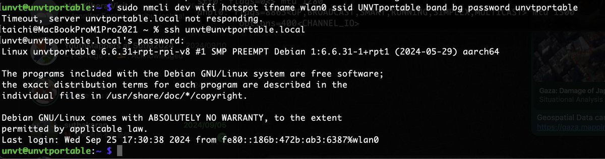
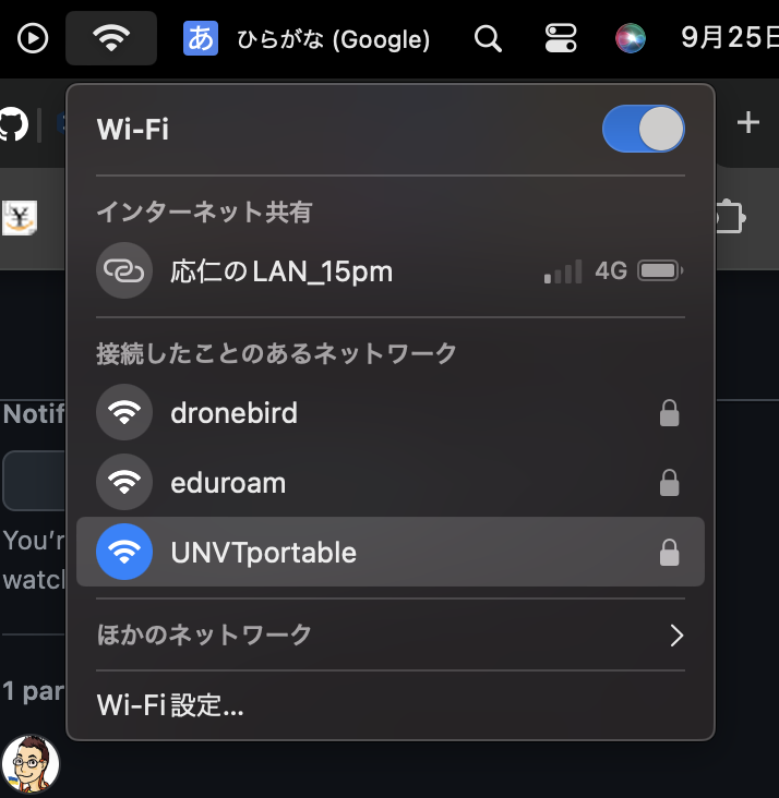
25 Sep 2024
インターネットが寸断された被災地でも利用可能なオフライン地図サーバ #UNVTPortable を、RaspberryPi OSデフォルトになったWi-Fi管理ツール NetworkManager に合わせて設定してみたら、今まで以上に簡単にWi-Fiアクセスポイント化できた。これは便利だ。 UNVT Portable 2024 はこれでいこう。あとはドローン空撮データ投入までのプロセスを簡便化するのが次のステップ。
#UNOpenGIS #SmartMaps #PoliMI #GEOlab #FuruhashiLab #DRONEBIRD #JapanFlyingLabs #古橋研究室
1
2
14
733