Tutorial About Ecological Evaluation Using UTFVI to Measure City Heat Levels
Registration link: studyhacksgeospatial.com/pro…
#GoogleEarthEngine
#RemoteSensing
#GIS
#Geospatial
#GeospatialAnalysis
#EarthObservation
#SpatialAnalysis
#GeoAI
#MachineLearning
#ArtificialIntelligence
5
16
777
🔥 Your City is Heating Up! Map Urban Heat with UTFVI 🌍
👉 Full Tutorial Link: UTFVI: youtu.be/OWQrmtVa7KA?si=mx4B…
Registration link: studyhacksgeospatial.com/pro…
#UTFVI #UrbanHeatIsland #GoogleEarthEngine #RemoteSensing #GIS #ClimateChange #LST #Geospatial #satellitedata
1
23
1,064
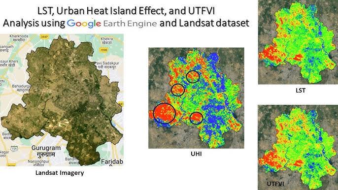
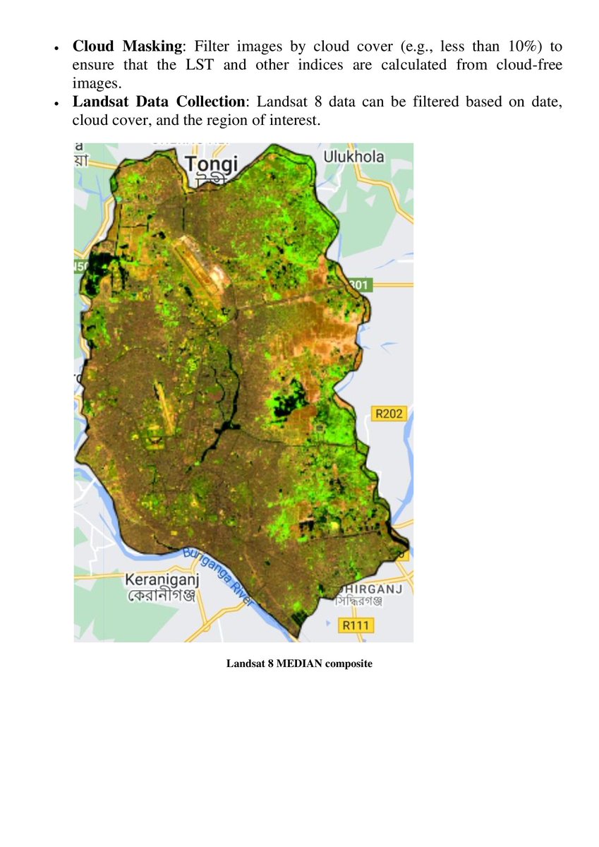
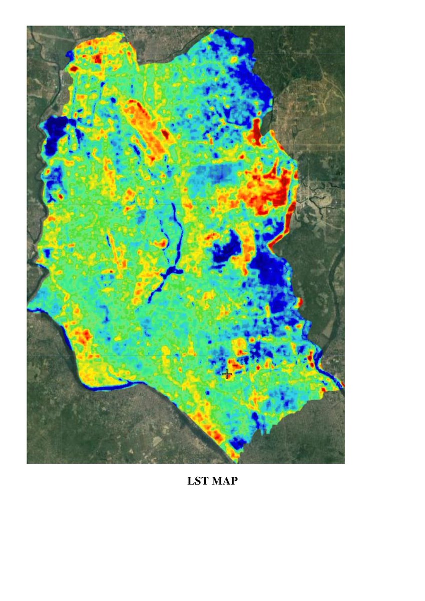
Tutorial about LST, Urban Heat Island Effect, and UTFVI Analysis using Google Earth Engine and Landsat dataset. To get tutorial link comment #GEE
Registration link: studyhacksgeospatial.com/pro…
#googleearthengine #GEE #GIS #remotesensing

1
2
27
1,086
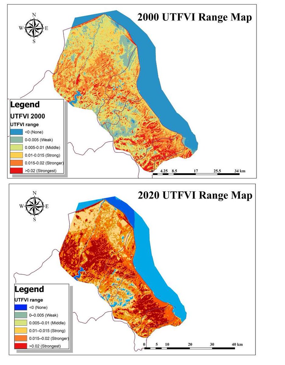
Tutorial: How to Calculate UTFVI for Urban Thermal Stress Mapping?
Tutorial Link: youtu.be/rbY39kLgeXM?si=4Pc4…
Registration Info link: studyhacksgeospatial.com/goo…
#googleearthengine #remotesensing #GIS #geospatial #GeospatialAnalysis #GeoAI
5
24
835
🔥 Is Your City Silently Overheating? 🔥
Most people talk about Urban Heat Island (UHI) —
but very few know about UTFVI (Urban Thermal Field Variance Index) 🌡️
Full Tutorial Link: youtu.be/rbY39kLgeXM?si=5rCx…
Registration Link:
studyhacksgeospatial.com/goo…
#googleearthengine #GIS #GEE
1
7
47
2,139
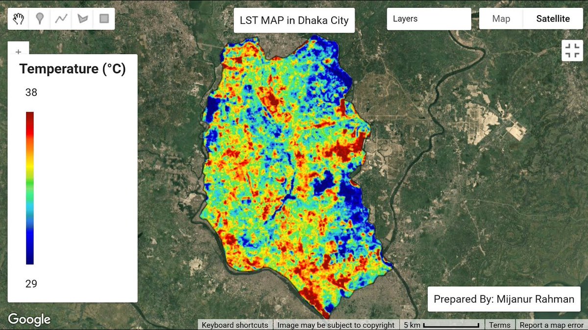
Interested in learning how to compute Land Surface Temperature (LST) using Landsat and MODIS satellite imagery, analyze Urban Heat Island (UHI), and derive the Urban Thermal Field Variance Index (UTFVI)?
Registration Info: studyhacksgeospatial.com/goo…
#googleearthengine #GIS
5
60
2,255
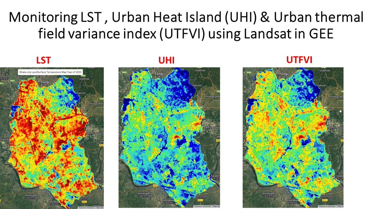
How to Calculate UTFVI for Urban Thermal Stress Mapping (GEE Tutorial)
Tutorial Link: youtu.be/rbY39kLgeXM
Registration Info: studyhacksgeospatial.com/goo…
#GISLearning
#ResearchTools
#climatescience
#datasciencetraining
#urbanstudies
#ClimateResilience

2
25
916
Tutorial about Estimating Land Surface Temperature, UHI, UTFVI Landsat
Tutorial Link: youtu.be/tcXHgpT9ttY
Reg Info: studyhacksgeospatial.com/goo…
#GoogleEarthEngine #RemoteSensing #UHI #GIS #Training #MachineLearning #Landsat #GeospatialAnalysis #Python
1
7
58
1,678

31 Aug 2025
Tutorial about Monitoring Urban Heat Islands with LST & UTFVI
Tutorial Link youtube.com/live/zmS_KBmXEzs…
Reg. Info:
studyhacksgeospatial.com/goo…
#RemoteSensing #GIS #Geospatial #Geoinformatics #EarthObservation #GeospatialAnalysis #SatelliteImagery #ClimateChange #EnvironmentalMonitoring

21
82
3,353
3 Aug 2025
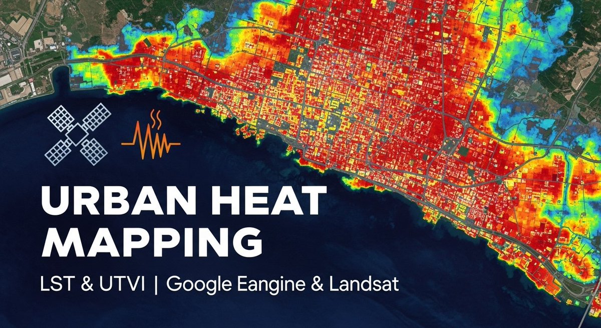
Mapping Urban Heat Islands with LST & UTFVI | Google Earth Engine & Landsat
Tutorial link: youtube.com/live/p9HIfKJ4Nws…
For more information about registration, visit our website: studyhacksgeospatial.com/goo…
#UrbanHeatIsland #LST #UTFVI #GoogleEarthEngine #Landsat #RemoteSensing
1
38
200
8,280
27 Apr 2025
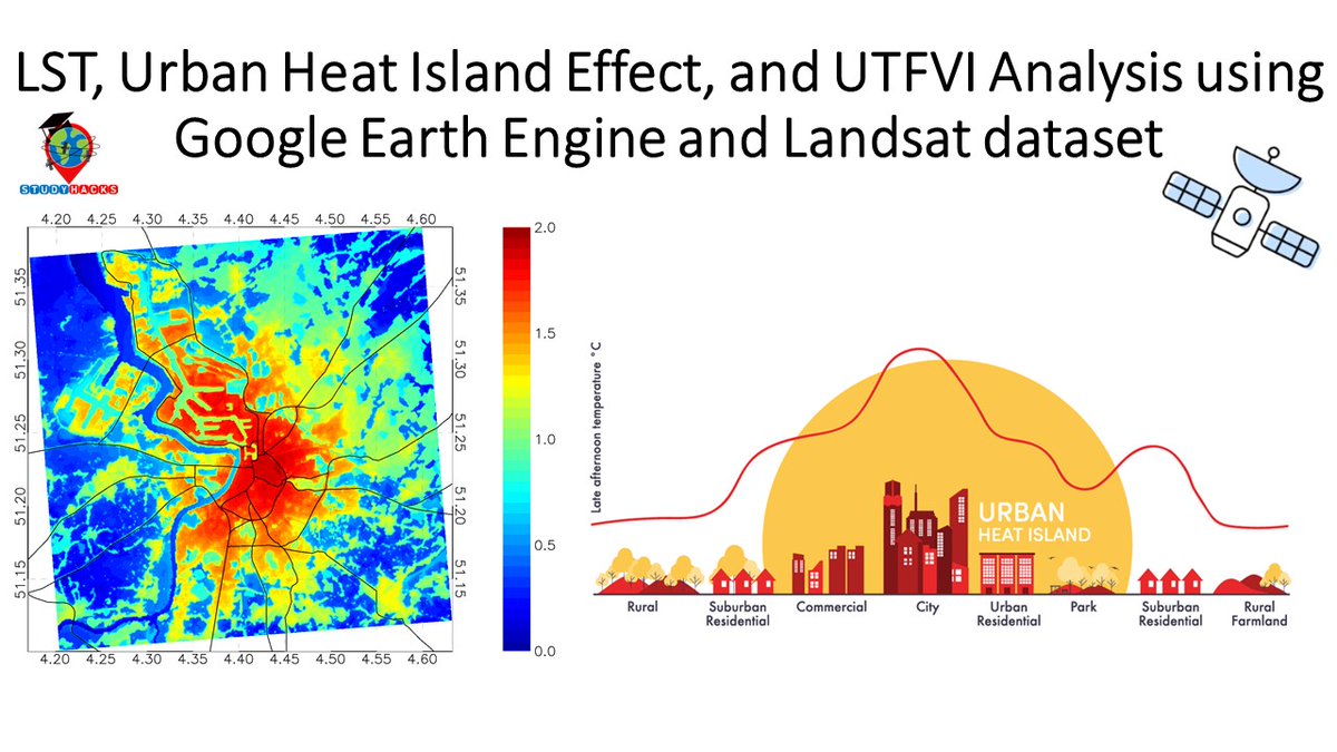
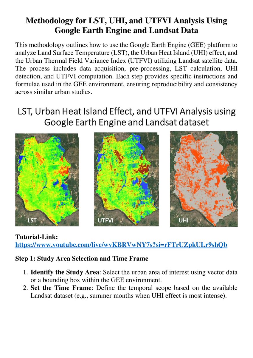
LST, Urban Heat Island Effect, and UTFVI Analysis using Google Earth Engine and Landsat dataset
Tutorial Link: youtu.be/WUghFT0UeXY?si=k4r2…
The Registration details: studyhacksgeospatial.com/goo…
#googleearthengine #gis #remotesensing #gis #geospatial #LST #GIS #geoscience
14
75
3,425
3 Apr 2025
LST, Urban Heat Island Effect, and UTFVI Analysis using Google Earth Engine and Landsat dataset: Part-1
Tutorial Link: youtube.com/live/MxdmfA1rruk
For more details visit our website: studyhacksgeospatial.com/goo…
#googleearthengine #gis #remotesensing
15
81
2,451
1 Apr 2025
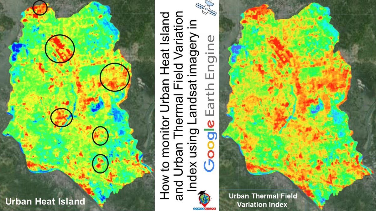
How to monitor LST ,Urban Heat Island (UHI) and UTFVI using Landsat imagery in Google Earth Engine?
Tutorial Link: youtu.be/OWQrmtVa7KA?si=aGkR…
The Registration details: studyhacksgeospatial.com/goo…
#googleearthengine #gee #EarthEngine #remotesensing #EE #geoscience #LST #UHI #UTFVI
14
64
2,078
14 Mar 2025
🌍 Master Google Earth Engine (GEE) for Remote Sensing & GIS Analysis! 🛰️ 🔎 Do you want to assess Land Surface Temperature (LST) and Urban Thermal Field Variance Index (UTFVI) using Landsat imagery in Google Earth Engin e? Check out youtu.be/OWQrmtVa7KA?si=R4TR…
#googleearthengine

12
46
1,812
18 Feb 2025
Monitoring Urban Heat Island (UHI) Urban thermal field variance index (UTFVI) using Landsat in Google Earth Engine
Tutorial link: youtube.com/live/lc-NqHXDvyE…
📜 Full Syllabus & Details: studyhacksgeospatial.com/goo…
#googleearthengine #gee #earthengine #gis #geospatial #arcgis #arcmap

1
15
63
2,920
2 Feb 2025
Assessing land surface temperature and urban thermal field variance index using Landsat imagery using Google Earth Engine.
Tutorial Link: youtube.com/live/cRQI0NNAVzg
The Full Course syllabus from this link: studyhacksgeospatial.com/goo…
#LST #googleearthengine #UTFVI #GEE #AI

1
14
63
3,026
30 Nov 2024
LST, Urban Heat Island Effect, and UTFVI Analysis using GEE and Landsat dataset
Tutorial Link: youtube.com/live/YQEID59LHkI…
Registration Open for 7-Day Online Live Training on Google Earth Engine for Remote Sensing & GIS Analysis
Registration Info: studyhacksgeospatial.com/goo…
#GEE
12
72
3,635
27 Oct 2024
LST, Urban Heat Island Effect, and UTFVI Analysis using Google Earth Engine and Landsat dataset
Tutorial Link: youtube.com/live/wvKBRVwNY7s…
Registration Info: studyhacksgeospatial.com/goo…
#EnvironmentalScience
#SmartCities
#ClimateTech
24
87
4,262
29 Sep 2024
LST, Urban Heat Island Effect, and UTFVI Analysis using Google Earth Engine and Landsat dataset
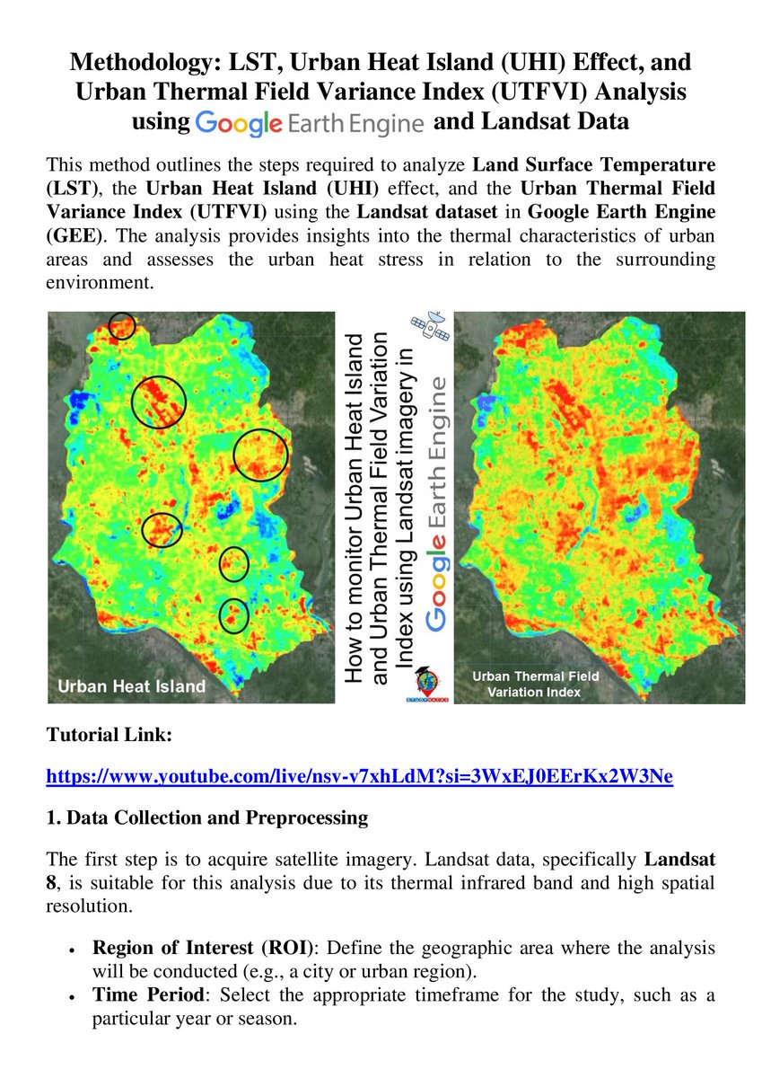
Tutorial Link: youtube.com/live/nsv-v7xhLdM…
For more details visit our Registration website: studyhacksgeospatial.com/goo…
#UrbanHeatIsland #LST #UTFVI #RemoteSensing #GoogleEarthEngine #Landsat8
16
83
3,372

3 Jun 2017
UIOAEGVAEIUOSGH(*!&)!)JHSUAIGBSPOAJSYG!POHS)!_)IULASHSPOJ!UTFVI!%¨$E@!SIJAG manoooooooo, hj vai se locooo
1