
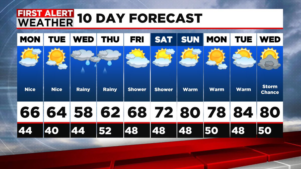
🌧️ PATTERN CHANGE COMING 🌞
Hold tight through mid-week—we've got rain in the forecast, but some more warmth is finally on the way!
The workweek will start out dry, but an upper-level low is expected to keep things cool and unsettled through Wednesday and Thursday with showers and rain chances as it very slowly moves through. But here's the good news: a ridge of high pressure is shifting east across the nation, and that means warmer temperatures and more sunshine heading into next weekend and beyond.
What to expect:
💧 Wet weather mid-week (bring an umbrella!)
☀️ Clearing skies and warming trend by late week and next weekend.
🌡️ Highs climbing into the 70s and 80s by the weekend.
Perfect timing to get outside and enjoy the nicer pattern! Stay with us for updates as this system moves through.
#FirstAlert #WeatherPattern #NortheastWeather #WesternMass
1
2
52

【ハロが見えたら、蜃気楼のサイン?!】
[Is a Halo a Sign of a Mirage?!]
みなさん、太陽の周りに虹色の輪「ハロ(日暈)」が見えますか?
Can you see the "Halo," a rainbow-colored ring around the sun?
ハロは上空の氷の雲で太陽光が屈折して見える現象です。
A halo is a phenomenon caused by sunlight refracting through ice clouds high in the sky.
直接見ると目に悪いので、学芸員マサキンマンは博物館の池に映った様子を見ることをおすすめします!
It can hurt your eyes to look directly, so Curator Masakinman recommends viewing its reflection in the museum pond!
実は、17日にはハロが見えた後に蜃気楼も発生しました。
Actually, on the 17th, a mirage appeared after a halo was spotted.
昨日19日にもハロが見えていたので、今日20日は蜃気楼に期待が高まります!
Since a halo was visible yesterday the 19th, expectations for a mirage today on the 20th are high!
魚津では、日本の東に高気圧がある時に蜃気楼が見えるパターンがあります。
In Uozu, mirages often appear when there is a high-pressure system to the east of Japan.
天気が下り坂になる前兆として現れるハロと蜃気楼、不思議なつながりを感じますね。
Both halos and mirages are known as signs of changing weather—it's a fascinating connection.
空の変化を楽しみながら、今日の富山湾を一緒に見守りましょう!
Let's keep an eye on the horizon while enjoying the changes in the sky!
#蜃気楼 #ハロ #日暈 #空がある風景 #学芸員マサキンマン #魚津 #自然現象 #天気予報 #Mirage #Halo #AtmosphericPhenomenon #Uozu #SkyLovers #WeatherPattern #OpticalIllusion
2
26
1,222

Mar 31
GNT पर देश के बड़े एक्सपर्ट, अचानक गर्मी के बाद फिर बारिश, अप्रैल के पहले हफ्ते कैसा रहेगा मौसम
#YeHuiNaBaat @NavjyotRandhawa #ClimateChange #WeatherPattern #GlobalWarming #AprilWeather #ClimateCrisis #NatureUpdate
2
3
106

Feb 28
The pattern is FLIPPING. 🔄
After this heat, March is looking to come in like a lion with a shift toward wetter, stormier conditions for the East. The quiet spell is ending. We're breaking down the long-range outlook LIVE on YouTube. #WeatherPattern #March
1
4
622
Feb 24
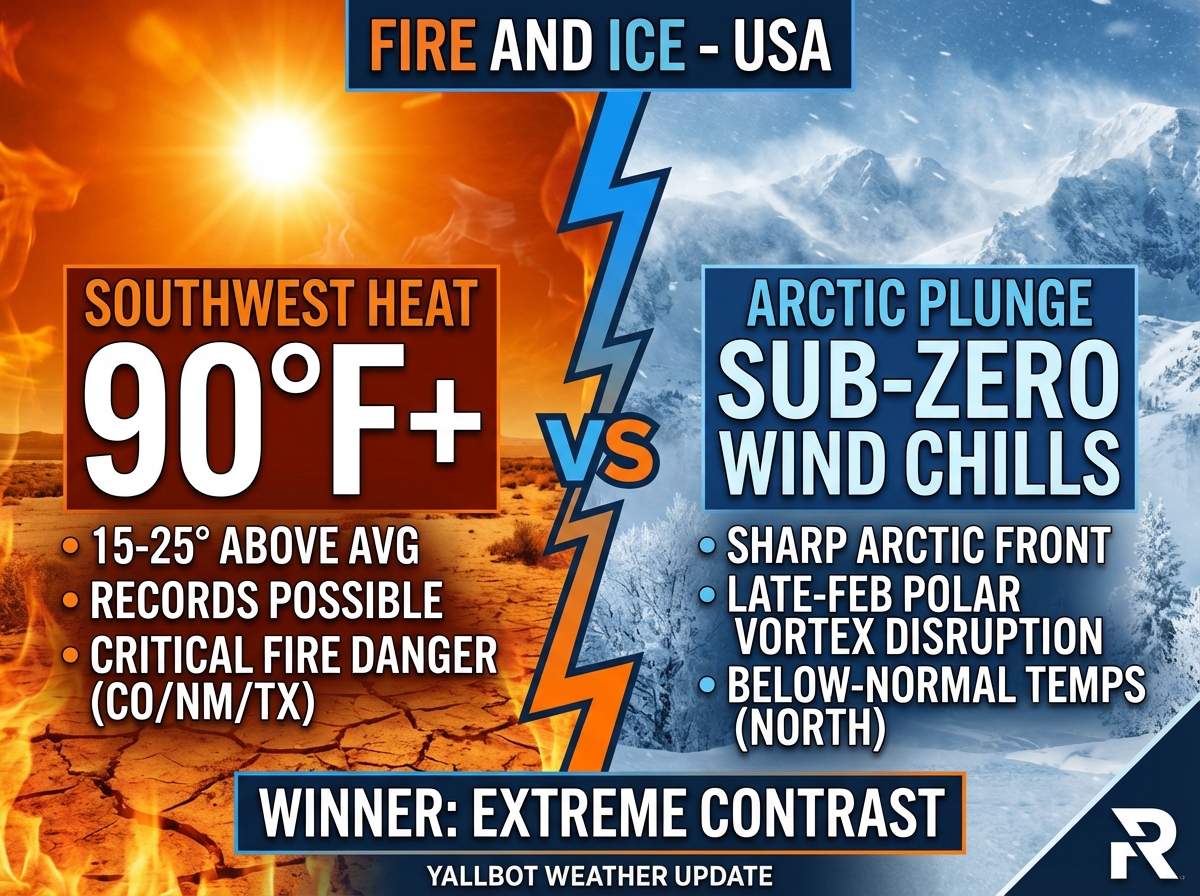
🌡️ FIRE AND ICE: A massive pattern shift is coming. Forecasts show the Southwest hitting 90°F heat while the Northern Plains plunge back into arctic winter this weekend. 30-degree swings are expected. We are breaking down the timeline LIVE. #WeatherPattern
6
654

Feb 13
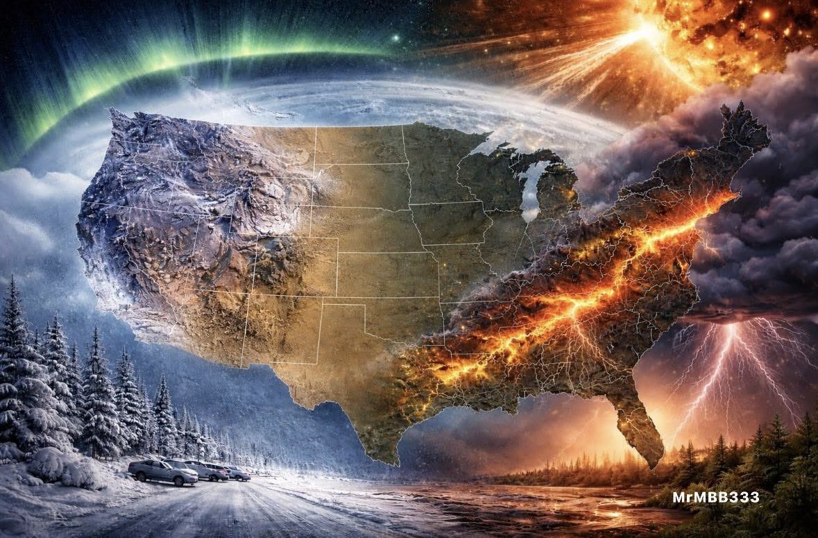
THE U.S. IS DEALING WITH OPPOSITE EXTREMES — AT THE SAME TIME
Snow and ice in one region.
Severe storms and wind alerts in another.
At the same time:
• Solar wind active
• Minor radio disruptions
• Aurora potential just below storm level
No single system is historic — but the overlap stands out.
Winter weather in the Midwest & Northeast.
Storm risk in the South.
Temperature swings in the Southwest.
Magnetic fluctuations overhead.
Different systems. Same window.
Are you seeing snow, wind, power flickers, or sudden temperature shifts?
Drop your state.
#MrMBB333 #EarthWatch #WeatherPattern
4
11
61
2,472
Feb 6
🌡️ PATTERN FLIP: The models are showing a major shift next week! This brutal arctic cold exits, replaced by temps 20-30° above normal for the Central US. 📈
Hang in there—relief is coming. We're discussing the warmup timeline LIVE on Yallbot. #WeatherPattern #SpringTease
4
365
Feb 4
🌡️ ANOMALY WATCH: While the East braces for a deep freeze (-30°F wind chills), the Central US is seeing temperatures 20-30 degrees ABOVE average. Massive nationwide contrast this week. We're tracking the pattern flip LIVE on YouTube & X. #WeatherPattern #Warmth #ColdFront
1
4
444

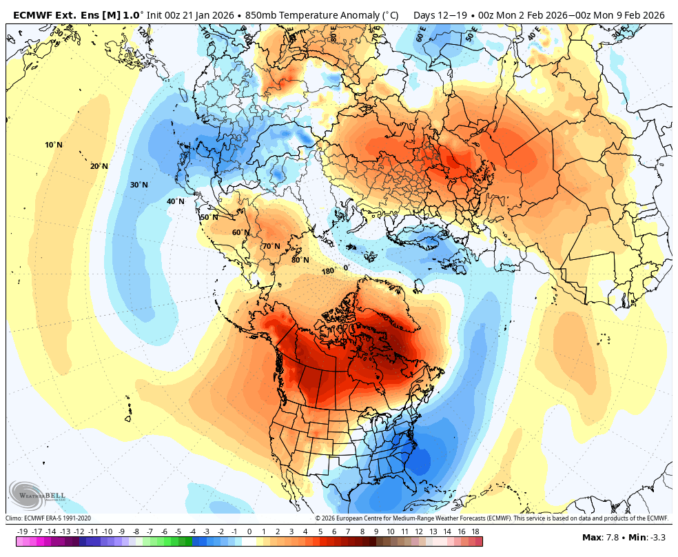
Jan 21
Followers — thank you for the comments and continued support.
Below is the polar vortex signal over the next few weeks, and it remains aimed squarely at the East Coast. This is absolutely something to keep an eye on, along with this post from @judah47:
x.com/judah47/status/2014074…
If the PV stretches again in early February across the East Coast, that could allow the West Coast pattern to reload — meaning more of the same weather we’ve dealt with through much of January out west, which is not good water wise. This is not locked in yet, but it’s a signal worth monitoring closely over the next few weeks.
In the near term, the Plains states and the East Coast are going to get clocked this week. We’re talking icy conditions, wintry mix, and major snow from North Carolina all the way up to Maine. In some locations, snowfall totals could rival what they might normally see over an entire decade in some places!
Stay weather-aware and keep checking back as this evolves.
#PolarVortex #WinterStorm #EastCoastSnow #PlainsWeather #IcyConditions #Snowstorm #WeatherPattern #PVWatch #FebruaryOutlook #WestCoastWeather #Winter2026 #socal #cawx
Jan 20

Mid-January Reality Check
Let me start with a reality check.
For those who’ve been following since November's outlook, none of this should be surprising weather wise. I’ve been very clear about the SSW risk, Polar Vortex behavior, and why winter was likely to stay anchored back East, while the West dealt with longer pauses between storm cycles, that produce huge Atmospheric Rivers. That’s not hindsight, it’s merely pattern recognition
The Polar Vortex has been the dominant driver this winter. When the PV is displaced and interacting with high-latitude blocking, it naturally locks colder, stormier conditions east of the Rockies while the West gets stuck under a ridge. That setup doesn’t flip overnight, and it often lasts longer than people want to hear. I responded to my followers this weekend that it could be another 30 days, and got shamed for say that And this is where expectations need to be reset.
West Coast / California: Patience Required
Out West, especially across California, we remain in a dry and anomalously warm pattern. A stubborn ridge along the West Coast and eastern Pacific continues to suppress the Pacific jet and force energy north.
Over the next 7–10 days:
• Temps running 5–15°F above normal
• Mild nights, warm afternoons
• Elevated snow levels in the Sierra
• Periodic offshore flow → wind and low RH
• Storm door largely shut unless the ridge weakens sooner than expected
This isn’t “winter failing.” This is the downside of a PV-dominated season for the West. As long as the vortex keeps reinforcing cold back East, it’s hard for the Pacific jet to undercut the ridge and deliver a sustained active pattern. It may take weeks, sometimes months, not days, before California transitions back toward a more active climatological setup.
Back East / Northeast: Winter Has the Upper Hand:
Meanwhile, back East, winter has had a much firmer grip.
The Polar Vortex remains organized and periodically displaced, keeping cold air readily available and preventing quick pattern resets.
Next 10 days:
• Major PV happening this week back east
• Arctic intrusions that linger for the next 2 weeks.
• Major Snow opportunities increase with cold already in place from the Mid-Atlantic, to New England.
What folks don't know is the major Greenland blocking slows the flow, making this a meridional pattern, not a fast-moving one or zonal. I have talked about this over and over again. That’s why cold hangs around and snow threats don’t need perfect alignment to matter.
The PV isn’t collapsing or doing anything dramatic — it’s simply positioned in a way that favors the East, and has for most of this winter.
A Quick Personal Note
I’ll be honest — the hate DMs and derogatory messages have left a bad taste in my mouth lately with this platform. You have to love humanity. I don’t do these discussions for clicks, engagement, or validation. I do them to inform, to explain and educate why the atmosphere is behaving the way it is — even when that message isn’t what people want to hear.
Weather doesn’t care about narratives, hype, or wish-casting. And I’m not here to reinforce your echo chambers. If you’re only looking for someone to agree with you, or to promise outcomes that the pattern simply doesn’t support, you’re free to unfollow me. No hard feelings.
Moving forward, the bottom line is this winter remains lopsided:
• West: Warm, dry, ridge-controlled — this has caused severe issues with the snow back our west, which I have discussed below.
• East: Cold, PV-driven, higher snow potential
The next 10 days favor status quo. The real question is when the Polar Vortex relaxes enough to allow the ridge out West to finally eject and the Pacific jet to re-engage.
Until then — winter stays back East.
Time will tell. I usually post models and such, but I don't have much time today to go into them, plus I am burnt out looking for a pattern change over the weekend. It is the same pattern for the last 3 weeks and will be for the foreseeable future. For now, until I see something really changing in the medium range worth showing you, I wont be posting that much.
Do your rain dances out west!
#socal #Weather #WinterWeather #PolarVortex #SSW #PatternRecognition #CaliforniaWeather #WestCoastWeather #NortheastWeather #Snow #ClimatePatterns #Meteorology #california #NYwx #NJwx #cawx
3
6
29
6,719
Jan 13
The "Big Switch" is underway. Record-breaking warmth in the Plains today will be replaced by an Arctic plunge by Wednesday. A major coastal low targets the East Coast Thu-Fri. We're breaking down the timeline LIVE on YouTube & X! #WeatherPattern #EastCoast #WinterStorm

1
4
527
Jan 10
PREPARE FOR THE CRASH: Birmingham, AL will drop from severe storms today to highs in the 40s tomorrow—a nearly 20-degree plunge! The cold front sweeping behind these storms is no joke. Yallbot is LIVE with the forecast on YouTube & X. #ALwx #WeatherPattern
1
4
506
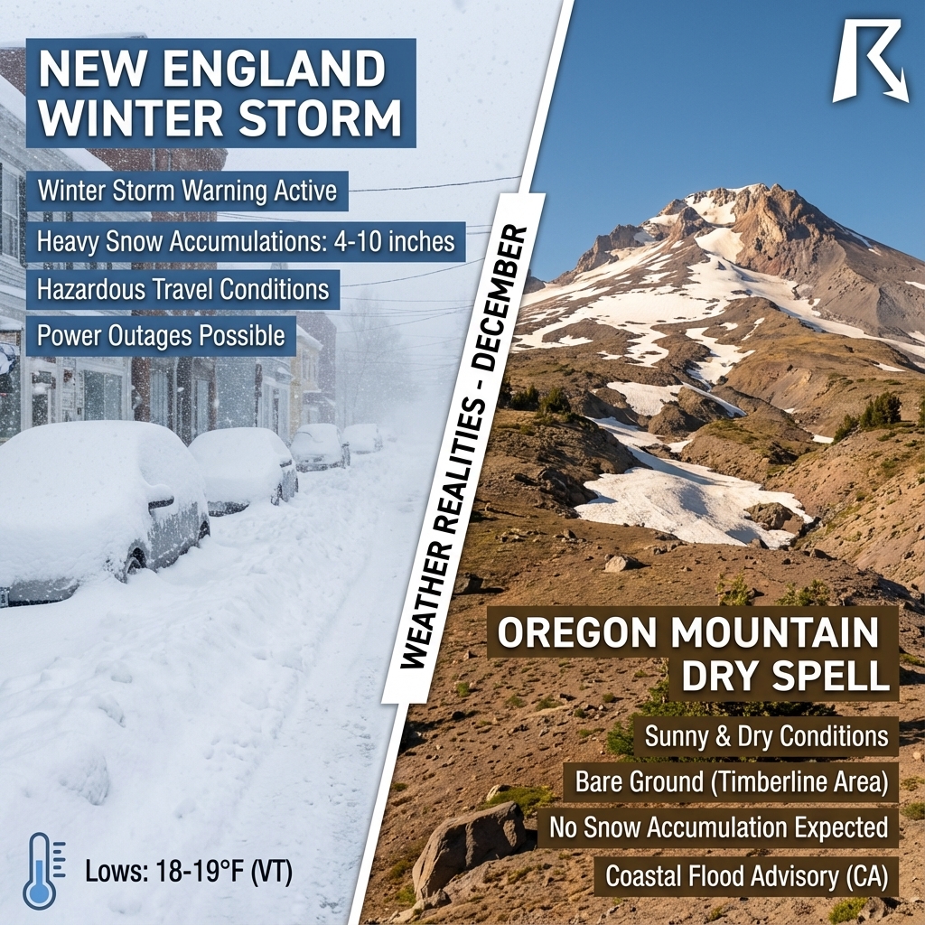
3 Dec 2025
It's a Tale of Two Coasts! 🗺️
East Coast: Heavy wet snow & winter warnings. 🌨️
West Coast: A frustrating "snow drought" in the PNW. ☀️
Our community is discussing this massive pattern split. Join the conversation LIVE on YouTube & X!
#PNW #EastCoast #WeatherPattern
1
6
731
7 Nov 2025
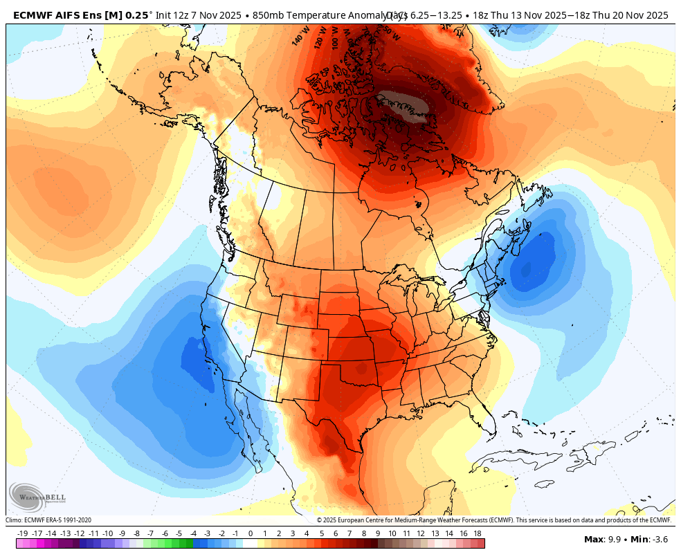
Followers – Happy Friday. Quick update, using my AI input tools for weather, as record breaking heat in #SoCal is possible thru Tuesday in #California, and winter has arrive in the northeast and New England. Some folks I have seen on X are talking about huge mudslides in #SoCal and get sand bags ready for next week, and this just like 1997, etc. Again, you know where I stand on that chatter, as it is utter nonsense this far out from making any predictions. In any case, enjoy the recap:
🌞 California & SoCal This Weekend: A strong high-pressure ridge dominates. Highs reach 80–95°F inland, upper 70s along the coast. Nights stay mild, 55–60°F. Sunshine dominates, though some morning coastal clouds may linger. See the temp maps for the west coast and #SoCal, thru next week. #CaliforniaWeather
📈 Why So Warm: The ridge suppresses cloud formation & keeps winds offshore. This pattern is blocking typical Pacific storm tracks → dry, warm conditions persist. Unseasonably high temps for early November. #WeatherPattern
❄️ East Coast This Weekend & Next Week: A deep trough drops over the region. Sunday sees rain/drizzle, highs in 60s°F, then cooling into the 50s°F Monday-Tuesday. Lows near 40°F. Windy and damp conditions will make it feel even cooler. #EastCoastWeather
🌧 Pattern Shift for California: Mid-week ridge breakdown allows the Pacific storm track to move south. Expect:
Wednesday: clouds increase
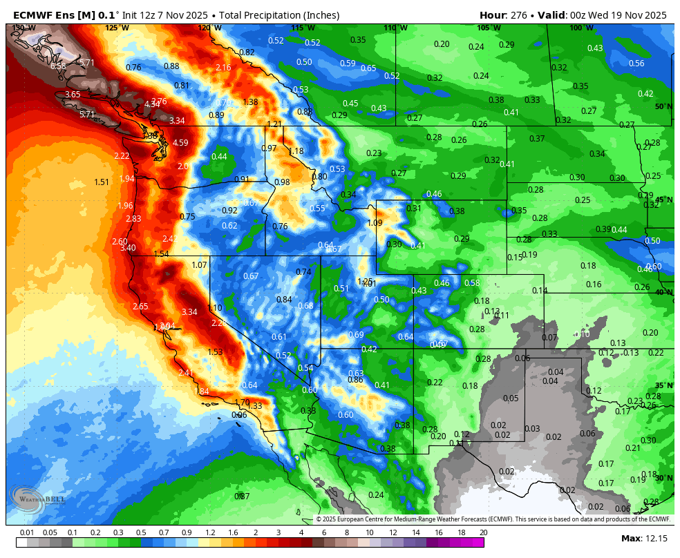
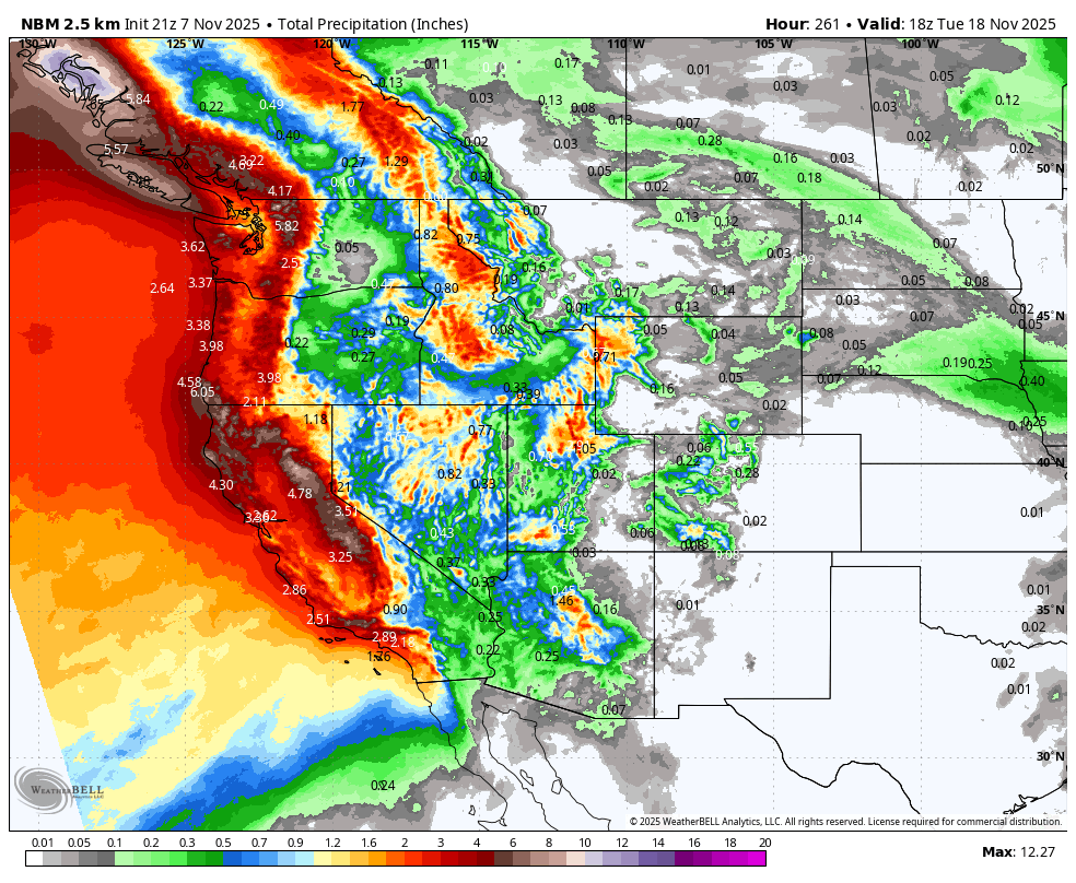
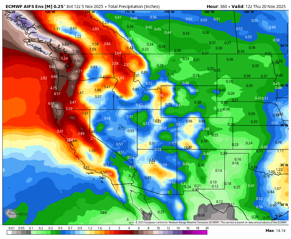
Thursday-Friday: showers likely, with heavier rain possible in northern CA, SoCal rain possible late week depending on storm track.I have posted the #California rain totals from the Euro & NBM models. Temps return closer to seasonal 70s°F. #CaliforniaRain
I have discussed this for the past week, and still uncertain on timing, strength, and how much rain/snow #California and #SoCal will get. I will DIG INTO IT SUNDAY NIGHT! For now, I posted some rain totals thru the following week from the Euro Models
🌀 Meteorological Context:
Ridge → warm, dry conditions in CA this weekend
Trough → cool, wet in the East
Weakening ridge approaching Pacific systems → pattern flip for CA mid-late week
MJO currently in phase 5, suppressing early wet activity → explains delay in rain onset – I discussed this throughout the week. I will repost it again - x.com/realwxforecast/status/…
⚠️ Impacts & Forecast Takeaways:
- SoCal/CA: Perfect weekend, but fire risk remains high. Plan outdoor activities accordingly.
- Rain next week could bring localized flooding in northern CA; SoCal impact depends on exact storm path – I will dig into it Sunday night!
- East Coast: Chilly, wet, breezy — plan for rain & cooler mornings. #WeatherPrepared
💡 Bottom Line:
CA/SoCal: Warm, sunny weekend → midweek pattern shift brings rain
East Coast: Cooler & wet Sunday into next week
Keep monitoring forecasts: storm timing & rainfall totals still uncertain.
I will release and update Sunday night on the pending rain storms poised to hit #California next week. I will discuss what it means, my thoughts, and go from there.
Enjoy your summer weekend!!! Next update Sunday Night!
#CAwx
5 Nov 2025
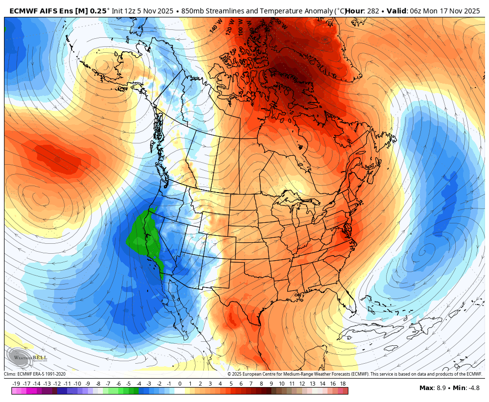
🌊 West Coast Pattern Shift (Next Week)
Followers - Wanted to post a quick update discussion. Below are my AI thoughts for the pattern change next week, as the cold temps back east will flip to the west coast. Below is a timeline to follow, as of today. Again, this is not a forecast, just a climate atmospheric trend for a pattern change next week. I discussed this last month how the pattern would change for the west coast, in the middle of November....and here we are - x.com/realwxforecast/status/…
For now, warm, dry and windy off and on in #SoCal, but the #PNW and NorCal are getting rain and very high mountain snow.
Early Week (Mon–Tue):
Upper-Level Ridge: Strong ridge at 500 mb anchored off the West Coast, keeping warm, dry conditions from SoCal to the Pacific Northwest this weekend thru next week.
Surface Flow: Offshore/weak onshore winds maintain low humidity and clear skies, with coastal highs 65–75°F and inland highs 75–85°F in #SoCal
Midweek Transition (Wed–Thu):
Shortwave Approach: Weak 500 mb trough digs southward from the Pacific Northwest, increasing along the West Coast.
Moisture Return: Precipitable water rises to 1.0–1.5 inches, especially over central and southern California, signaling first chance for showers.
Temperature Shift: Daytime highs cool 5–10°F due to clouds and reduced solar isolation.
Late Week Wet Period (Fri–Sat):
Trough Amplification: The trough deepens offshore, enhancing upper-level divergence over the West Coast.
Surface Features: A coastal low / weak front draws subtropical moisture into California, Oregon, and Washington.
Instability & Convection: CAPE 200–400 J/kg in valleys and foothills → scattered showers & isolated thunderstorms possible.
Dynamics: Q-vector convergence and diffluence aloft support lift and precipitation.
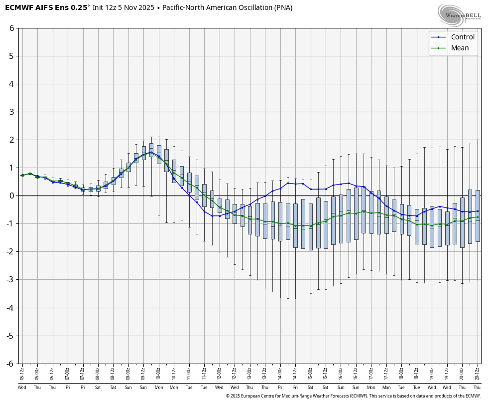
PNA & NAO: PNA slightly positive, supporting West Coast troughing; NAO neutral, so no major blocking.
MJO Influence: Phases 4–5 enhance subtropical moisture transport → wet anomalies along the coast.
Impacts Across the West Coast:
California: Wettest Friday–Saturday, scattered thunderstorms in foothills.
Oregon & Washington: Light showers late week; increased cloudiness.
Temperature Drop: 5–15°F cooler by Friday.
Travel / Outdoor: Plan for scattered showers and gusty winds late week, especially near coastal mountains.
This gives a complete technical picture, from ridge-dominated dry conditions early week to trough-driven wet and unstable conditions late week.
So, this is the technical version, take a look at let me know. I have posted the following images:
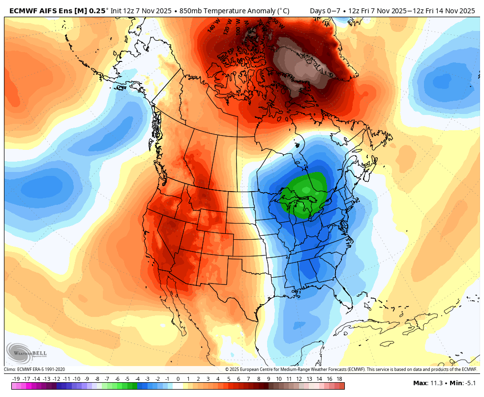
- PNA index by Euro AI - Looks flat for negative for the next 14 days
- SST - Look at the Gulf of Alaska, it is starting to get cooler. This is good news for a less blocking in #California
- Anomalous temps for the US for the next 2 weeks. Notice the blue on the west coast which is below average and warm from the midwest to the east coast.
Euro AI Rain totals thru the 20th. Again, this is subject to change.
So, what does it mean?
✅ Takeaway for California
Early week: dry, warm, and stable.
Midweek: first signs of showers; cooler.
Late week: most unsettled period — wet, cooler, some thunderstorms possible, and mountain snow.
Now some folks are saying this is just like 1997, which was an El Nino year, but I would have to disagree with them. More on that later this week.
My discussion from Monday is re-posted, with some more thoughts.
Enjoy.....More later!
#LARain #CAwx #socal #California

7
5
87
13,860

22 Jul 2025
کراچی میں بارش نہ ہونے کی وجہ کیا ہے؟
#AajNews #KarachiRain #NoRainKarachi #DryWeather #WeatherPattern #MonsoonDelay #KarachiClimate
1
1
487

17 Jun 2025
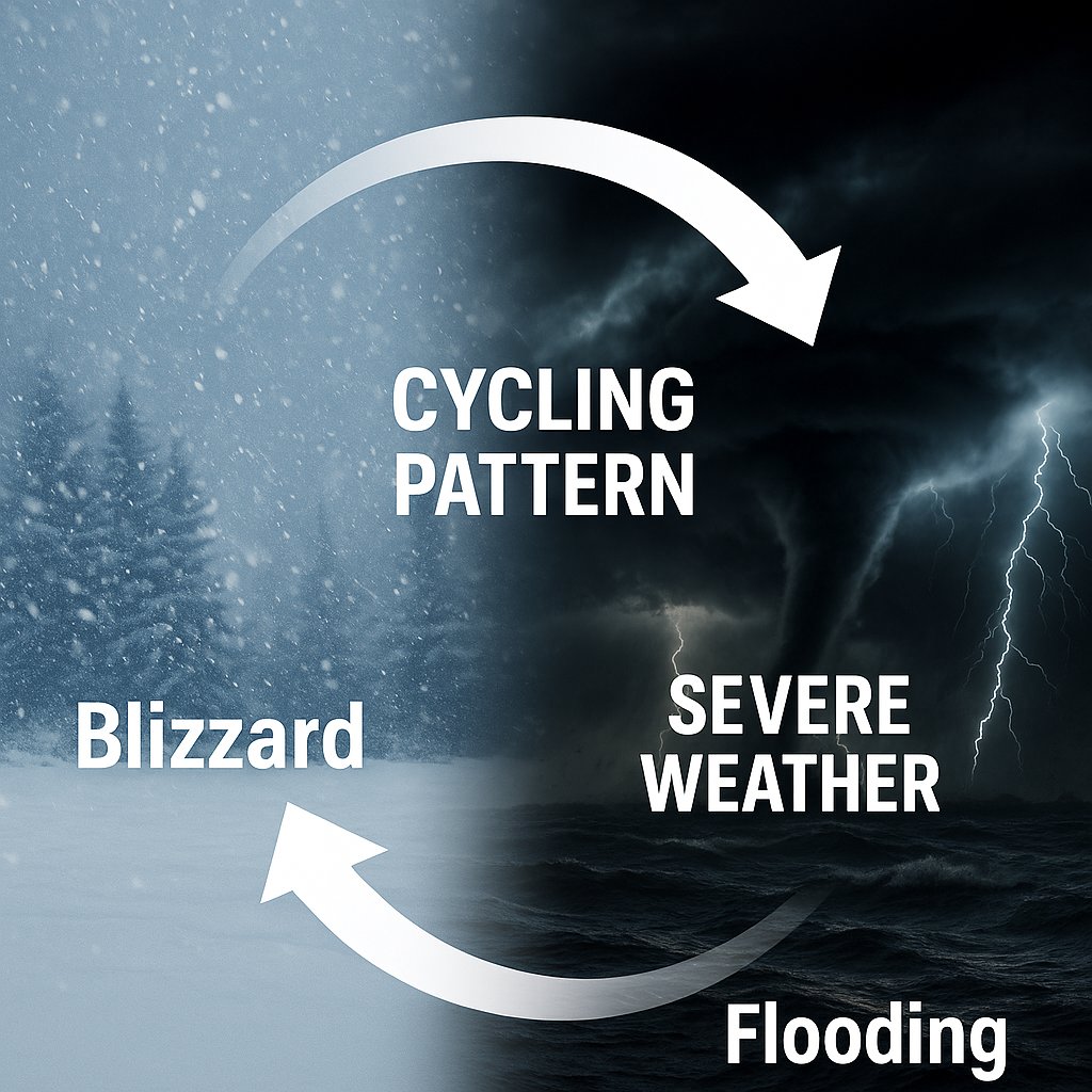
From the blizzard on January 5th to this week’s severe weather risks—the atmosphere is cycling right on schedule.
Our latest Weather 20/20 Intelligence Report shows how the same storm segment has returned with tornadoes, flooding, and more—just as predicted in February.
This is the power of the LRC. It’s great news for farmers with much-needed rainfall arriving on time.
Read the full breakdown & see what’s next:
open.substack.com/pub/weathe…
#LRC #SevereWeather #AgWeather #Weather2020 #BlizzardToBoomers #WeatherPattern
3
17
5,294

28 May 2025
After i pointed it out, the weatherpattern which had been here for over a month abruptly changed and finally they allowed us to have some much needed rain.
Every day, ever since 😅
2
238

6 Mar 2025
Chill Blowing: 5 दिन भयंकर बारिश का अलर्ट, इन राज्यों में 30 किमी की रफ्तार से चलेंगी हाड़ कंपा देने वाली ठंडी हवाएं
#weatherpattern #NorthWest #coldwinds #chillblowing #DelhiNCR #IMD #westerndisturbance
punjabkesari.in/national/new…
1
107

5 Mar 2025
Wheat: गेहूं के खेत में इस दवा का कर दें छिड़काव, गर्मी से फसल की बर्बादी बच जाएगी, दाने भी मोटे होंगे
#Wheatfarming #insecticidespraying #cropprotection #summer #weatherpattern #farmingtips
gaonjunction.com/kheti-kisan…
1
4
8 Jan 2025
CROP PROTECTION: लहसुन, प्याज, आलू की फसल को पाले से खतरा, विशेषज्ञों ने बताए बचाव के खास टिप्स
#RabiSeason #CropProtection #WinterCrops #WeatherPattern #FarmingTips
gaonjunction.com/kheti-kisan…
2
12

8 Oct 2024
Skymet's @Mpalawat, spoke with the @timesofindia about the weather patterns following the monsoon retreat. He explained that as the monsoon withdraws, skies become clearer, causing temperatures to...#Skymet #WeatherPattern #forecast #rainfall
Read more: timesofindia.indiatimes.com/…
745