
je schelden helpt je niet, die mails worden door niemand ontkent. nahja. jij dan toch. maar zn advocaten hebben niemand aangeklaagd. ze zijn er. en echt. dat digitale spoor viel niet te wissen. de flightdata zouden we t nog over kunnen hebben? (ik zeg dat die is weggemaakt)
1
1
6

🚨✈️ The delay in the final report is not unusual.
What matters is why investigators still need more time.
The preliminary findings pointed to one of the most extraordinary and controversial sequences in modern aviation:
⚠️ Both engine fuel control switches reportedly moved from RUN to CUTOFF within seconds of each other shortly after takeoff.
That immediately expands the investigation beyond the engines themselves and into the entire chain of events:
🔹 Human factors
🔹 Cockpit procedures
🔹 Switch design and ergonomics
🔹 Engine Management Unit (EMU) logic
🔹 Electronic command pathways
🔹 Data recording integrity and sequencing
🔹 Potential system anomalies
The fact that investigators conducted engine testing and traveled to France to examine the Engine Management Unit suggests they are trying to answer the most important question of all:
❓ Was the fuel cutoff commanded, triggered, induced, or recorded incorrectly?
Until that question is answered conclusively, any final report risks being incomplete.
Aviation accident investigations are not criminal trials or media events.
They are engineering exercises designed to ensure the next crew never faces the same chain of failures.
📊 A rushed report may satisfy headlines.
✈️ A thorough report may save lives.
The deadline matters.
The truth matters more.
Until investigators can explain with confidence how both engines were deprived of fuel seconds after takeoff, the central mystery of Flight 171 remains unresolved.
⚖️ Aviation safety is built on facts, evidence, and certainty—not speculation or calendars.
— Grippan65Momi / Topgun0512 ✈️📊⚙️⚫
#AirIndia171 #B787 #Aviation #FlightSafety #AirCrashInvestigation #AviationSafety #EngineFailure #Boeing787 #PilotTraining #FlightData #AviationAnalysis #Grippan65Momi #Topgun0512 🚀✈️📈
2
1
407

May 27
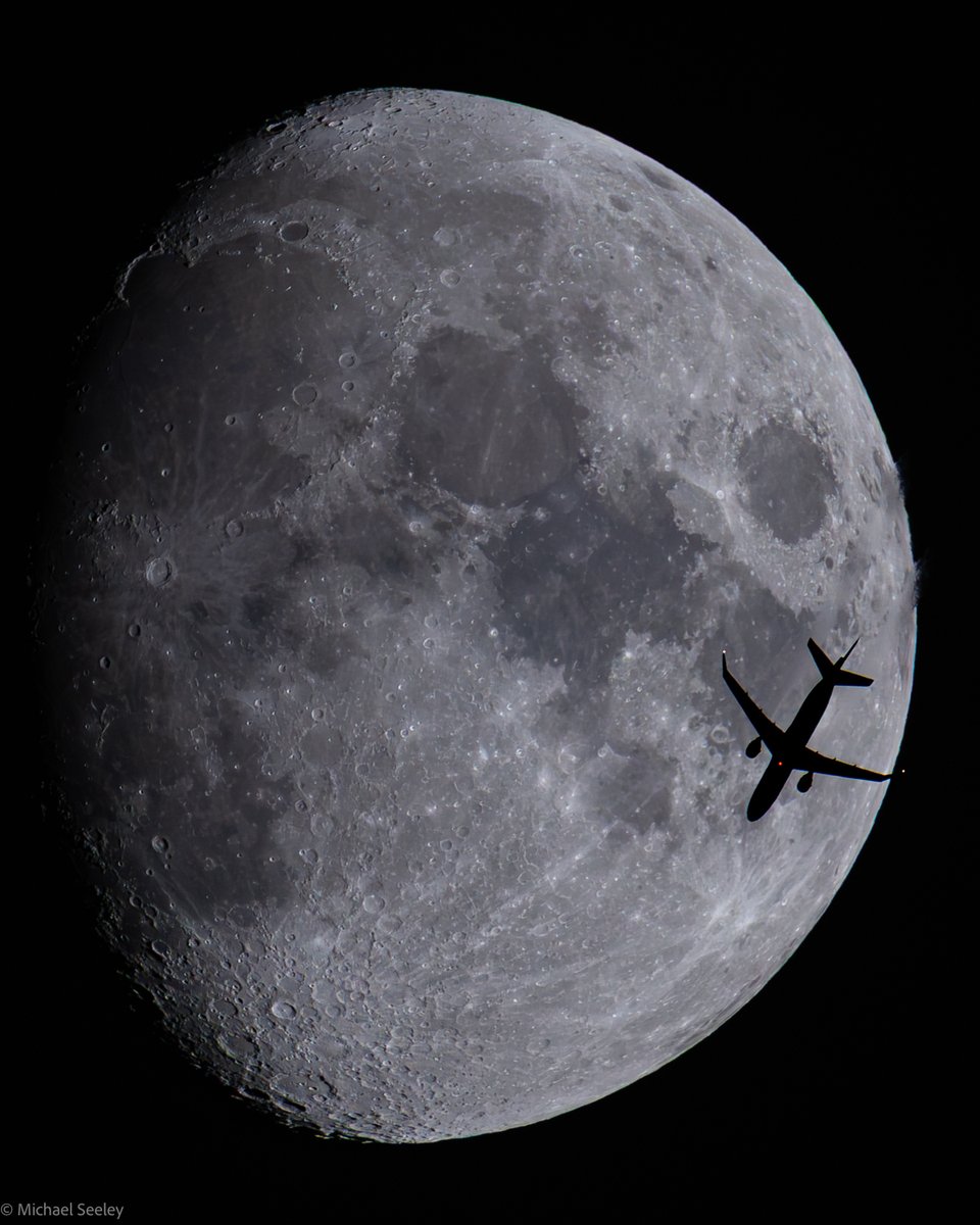
American Eagle, now with trips to the Moon?
Operated by Envoy, @AmericanAir 4057 was traveling from Cleveland (CLE) to Miami (MIA) as it passed in front of the Moon Tuesday night over the Space Coast of FL.
The Embraer E175LR (reg N341MB) was flying at 36k ft & 450 kts.
(📷:me, flightdata:@flightradar24)
4
3
49
3,616

May 9
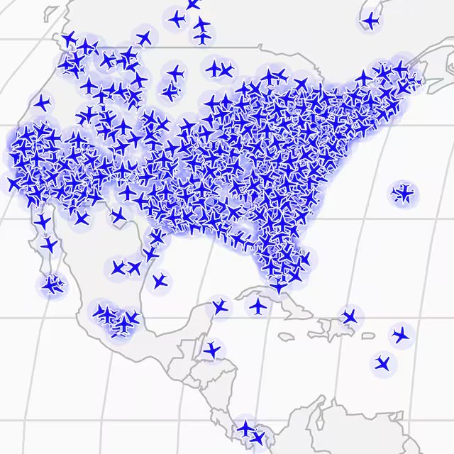
EARLY WARNING SYSTEM: Want to track the apocalypse? Follow The World's Richest Man, @ElonMusk, And The Other Billionaires’ Jets...
DOOM DASHBOARD: An artist made a warning system to notify you if the ultra-rich flee city centers en masse.
SKY SURVALENCE: They have endless amounts of money. Sophisticated bunkers. Private jets. Might the oligarchs of the world know — or be warned — in advance of a nuclear apocalypse?
So goes the theory underpinning the newest project from Los Angeles artist and coder Kyle McDonald, who has created what he calls an Apocalypse Early Warning System by tracking private jets around the world.
If a large number of jets suddenly flee city centers, transporting their likely affluent passengers to bunkers and isolated resorts, he figures it might be a warning sign for the rest of us.
McDonald’s project uses publicly available flight data to track the locations of private and business charter jets, planes often boarded by the super rich, and chart a “historic emergency level.”
It looks at how many planes are flying at one time compared to a baseline and rates it on a scale of 1 to 5.
If the level spikes, McDonald’s system can warn followers by text or email.
The apocalypse tracker hits on a growing divide and sense of resentment between working and middle-class Americans and the very, very rich.
In the U.S. alone, the top 1 percent of the population holds 31.9 percent of total wealth, according to the Federal Reserve.
The bottom half holds 2.5 percent. The richest person in the world, @SpaceX, @Tesla, @xAI, @Grok, X.com. @Neuralink and the @BoringCompany mogul Elon Musk, has increased his wealth by more than $50 billion this year alone....
washingtonpost.com/business/…
FILED UNDER:
#ApocalypseTracker, #BillionaireJets, #EarlyWarningSystem, #EliteFlight, #DoomsdayPrep, #PrivateJets, #UltraRichFlee, #ApocalypseAlert, #BunkerBillionaires, #JetTracker, #KyleMcDonald, #WealthInequality, #OligarchEscape, #NuclearApocalypse, #RichFleeCity, #FlightData, #EmergencyLevel, #ElonMusk, #MuskJets, #BillionaireBunkers, #ClassDivide, #TopOnePercent, #WealthGap, #EndTimesWarning, #TrackingTheRich, #SurvivalSignal, #AffluentExodus, #DoomWatch, #PrivateAviation, #EliteEvacuation, #Apocalypse2026, #RichRadar, #BillionaireWatch, #FlightSurge, #PanicPlanes, #WealthWarning, #JetMigration, #OligarchAlert, #EndOfWorldTracker, #BillionaireExodus, #SkySurveillance, #DoomDashboard, #ApocalypseSystem
5
216

Apr 25
@lufthansa just cut 20,000 flights through the fall.
@KoreanAir_KE is in emergency management.
Philippine Airlines has fuel secured only through June.
This is what a supply shock looks like when it hits an industry with thin margins, no fuel hedging, and limited operational flexibility.
The carriers in the best position right now share one thing: they know exactly where their aircraft are, what they're burning, and how to reroute before it costs them.
Real-time ADS-B data isn't the whole answer. But without it, you're making expensive decisions on delayed information.
#IranWar #Lufthansa #AviationCrisis #JetFuel #FuelHedging #ADSB #AirlineOps #FlightData
1
3
172

Apr 15
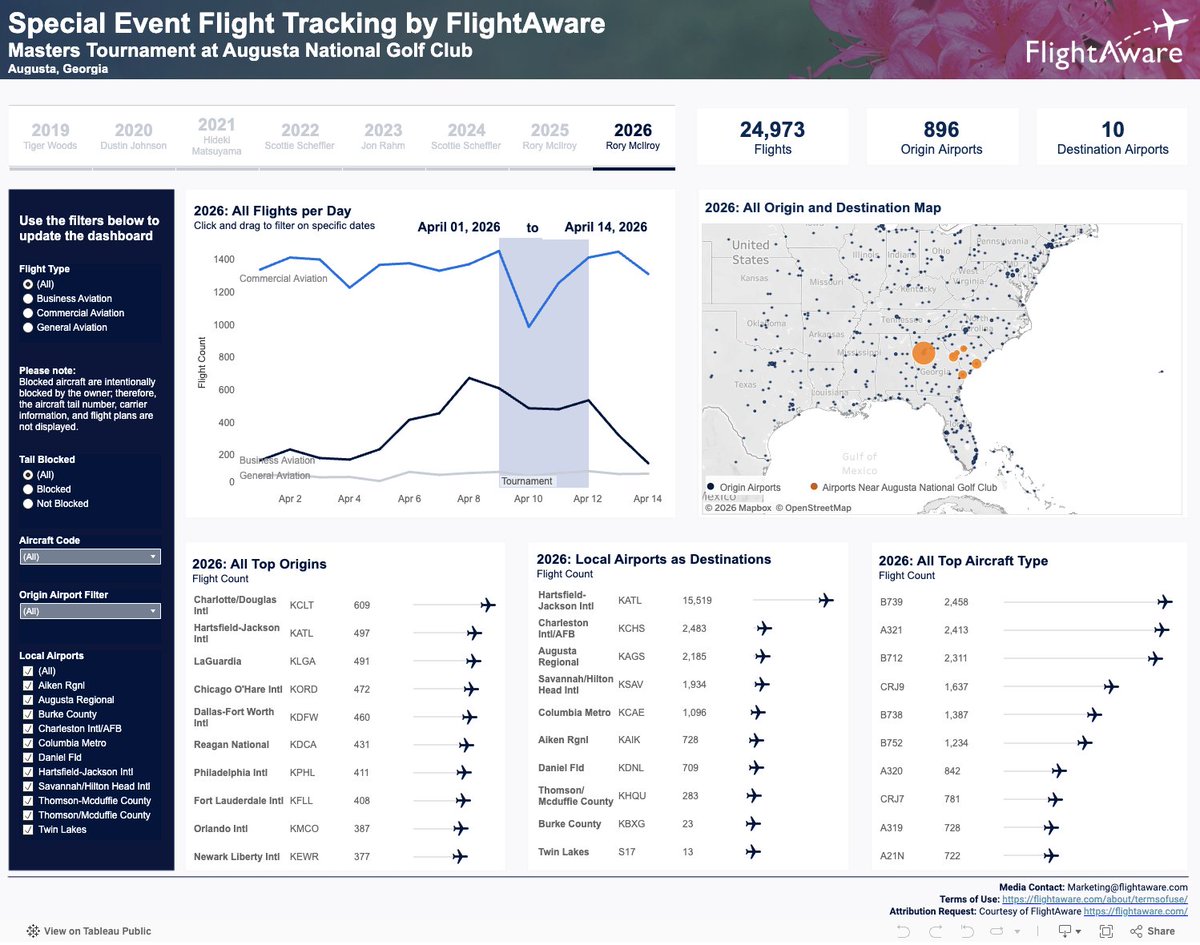
The annual surge of air traffic during the #TheMasters Tournament shows how closely #aviation and global events are connected.🏌️⛳
Check out the data here: hubs.li/Q04c9G9N0
#AvGeek #FlightData #BigData
14
2,127

Mar 31
Qatar Airways hits a post-crisis peak with 172 flights on March 30, a 41% jump in one week. Operations are recovering after the sharp decline earlier this month.
Source: Al Jazeera Open Source Unit.
#QatarAirways #Aviation #FlightData #Qatar #TravelNews

2
338

Mar 26
Final hours at the NBAA Schedulers & Dispatchers Conference 2026.
If you’re still around, stop by Booth 1268 to explore our flight tracking data solutions.
We’ve been showcasing FlightWatch, demonstrating how AirNav Systems turns real-time flight data into actionable operational intelligence. Designed for airlines and fully scalable across business aviation, it delivers the visibility today’s fleets require.
Let’s connect before the event wraps up.
#NBAA #NBAASDC #SDC2026 #FlightData #Aviation


1
3
870


Feb 28
अजित पवार प्लेन क्रैश मामले की जांच की जा रही है। AAIB आज प्रारंभिक रिपोर्ट जारी कर सकता है। ब्लैक बॉक्स डेटा से दुर्घटना के नए तथ्य सामने आएंगे।
#AjitPawarDeath #planecrash #AAIBReport #BlackBox #FlightData #rohitpawar #SunetraPawar #cbiinvestigation
4
15
693
80 KIAS… then CUTOFF?! 😳
Before you jump to conclusions: “maximum RECORDED speed” often just means the highest IAS sample in the recorder trace (a peak), not a different data source.
Events = “as per EAFR.” Peaks = “recorded.”
#B787 #FlightData #Aviation @MoCA_GoI @DGCAIndia
youtu.be/FRhCLO5YRqQ
1
1
3
963

Jan 17
The unspoken rules of flying, backed by data 📊✈️ 1,000 travelers weighed in on what's acceptable and what's not. Turns out, most people are pretty reasonable!
What else would YOU add to this list?
#Airfarewatchdog #TravelTips #FlightData #TravelSmart #AirplaneEtiquette

2
4
4,425


23 Nov 2025
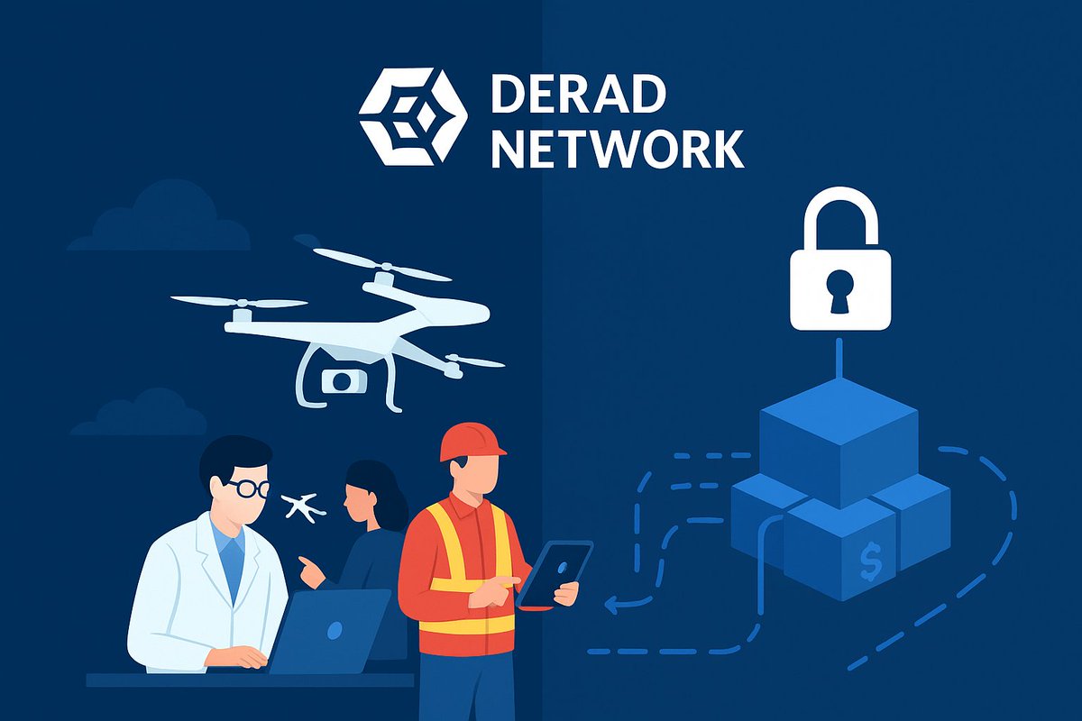
Can A Decentralized Ground-station Network Fix The World’s Aviation Blind Spots?
Have you ever noticed how flight maps show smooth, perfect routes yet huge parts of the sky remain completely unmonitored?
Pilots know it. Drone operators feel it and anyone in logistics or emergency response discovers it the hard way.
The world depends on real-time aviation data, but many regions still operate in partial darkness. A single missing ground station can make an entire area disappear from tracking. Traditional systems rely on expensive infrastructure, overloaded volunteers & outdated models that can’t meet modern airspace demands.
When visibility breaks, everything breaks — safety, coordination, response time, and trust.
This is the challenge @deradnet is built to solve.
What Is Derad Network?
Derad Network is a decentralized aviation data infrastructure that collects, validates, and distributes ADS-B signals through a global network of independent ground stations. These low-cost antennas capture aircraft position, altitude, speed, and motion.
Node operators earn rewards based on accuracy, uptime, location, and data value.
In simple terms: Derad is building a community-powered global radar system.
How Derad Solves the Aviation Blind Spot Problem
1. Eliminating Coverage Gaps
Derad incentivizes deployments in underserved regions, expanding coverage instead of concentrating nodes in easy areas.
2. Improving Data Reliability
Stations earn for delivering accurate, clean signals. Derad cross-checks data across the network to ensure reliability.
3. Scaling Without Central Gatekeepers
Its decentralized model removes reliance on costly corporate or government infrastructure, allowing fast, organic growth.
4. Making Aviation Data Accessible and Verifiable
Derad avoids restrictive paywalls by prioritizing open, transparent flight data.
What Makes It A Game Changer
1. Community-run infrastructure
2. Automated accuracy validation
3. Incentives for underserved regions
4. Low-cost antennas anyone can deploy
5. Open, verifiable real-time flight data
Derad blends #DePIN, aviation tracking, and data integrity into one accessible system.
Why It Matters & The Bigger Picture
Aviation now includes drones, delivery fleets, rescue aircraft, private flights, and new mobility vehicles. As skies grow busier, real-time visibility becomes essential for safety, compliance, drone routing, and logistics. Traditional tracking wasn’t built to scale this quickly.
Derad shifts the model from centralized control to global participation. By distributing ground stations, it moves ownership of critical airspace data to communities, enabling organic expansion, transparency, and innovation. This represents a future where visibility is shared rather than siloed.
How People Can Benefit
✅ Node Operators – Earn rewards for deploying and maintaining stations.
✅ Aviation & Logistics Companies – Access broader, more accurate coverage.
✅ Drone Operators – Gain dependable low-altitude tracking.
✅ Developers & Researchers – Use open datasets for analytics and modelling.
My Takeaway
The more I explore Derad, the clearer it becomes: aviation’s future can’t rely on a few centralized systems.
Decentralization brings resilience, expands visibility, & democratizes access. @deradnet is shaping a future where communities help maintain transparency across the sky.
Final Call
If you believe aviation data should be global and accessible, explore Derad Network, learn how the nodes work, and consider joining the ground-station ecosystem. Your antenna might illuminate a region the world has never seen clearly.
#DeradNetwork #FlightData #AviationTech

5
40
139

11 Nov 2025
Bir C-130 düşünce ülkede herkes bir anda;
Uçak mühendisi,
Füze radar uzmanı,
Derin analizci moduna geçiyor…
Oysa askeri uçak kazalarında ilk 24 saat kesin bilgi çıkmaz. Şu an konuşulanların �’ı yorum. %1’i kopyala yapıştır teknik terim.
Üstelik C-130’ların büyük kısmı 40 yıllık ve yoğun görev temposunda.
Her kaza komplo değildir. Bazen yorgun uçak, bakım yükü ve görev şartları aynı anda çakışır.
Bekleyelim, veri gelsin…
Sonra konuşuruz…
#C130 #TSK #HavaKuvvetleri #Asker #Savunma #Türkiye #Haber #Gündem #Kaza #AcilDurum #FlightSafety #Aviation #MilitaryAviation #AirForce #Aerospace #Pilot #Uçuş #Güvenlik #SivilAskeriHavacılık #Havacılık #Ankara #İstanbul #TürkiyeGündem #BreakingNews #Turkey #TurkishAirForce #AviationSafety #Crash #AviationNews #Breaking #Defense #Aircrew #SearchAndRescue #EmergencyResponse #Investigation #AviationCommunity #MilitaryNews #GlobalAviation #LiveUpdate #Developing #MediaWatch #AvGeek #FlightData #RadarTrack #ADSb #AviationAnalysis

3
841

22 Oct 2025
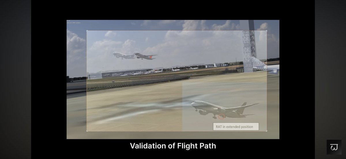
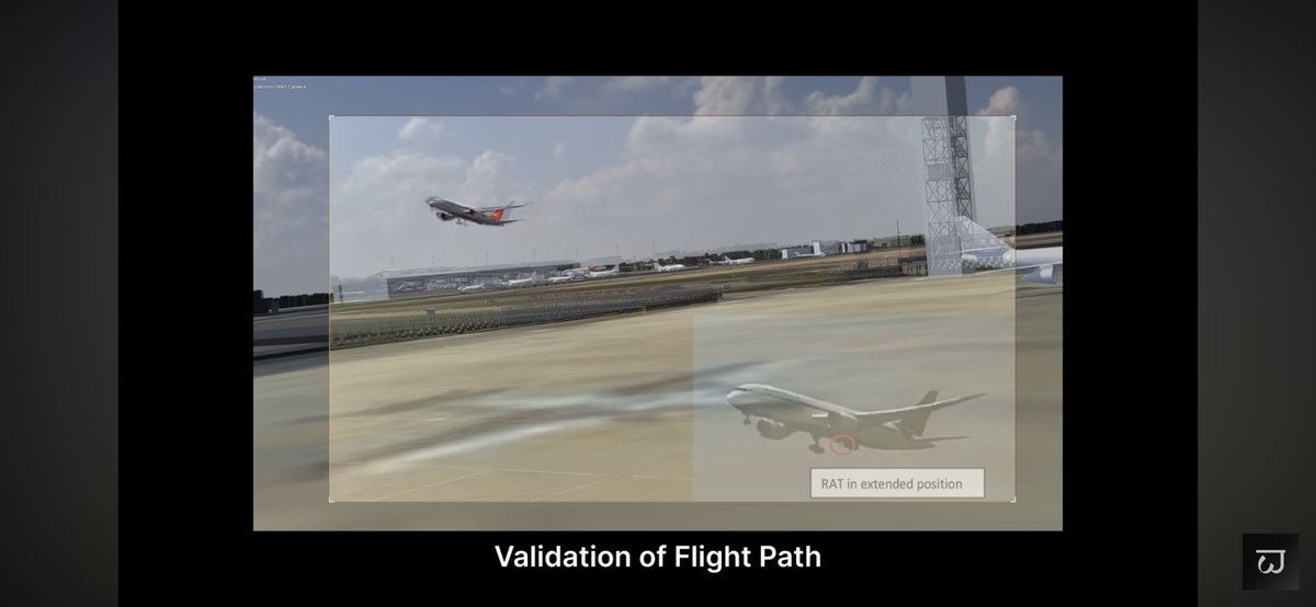
8️⃣
🧠 The RAT tells the truth when the data doesn’t.
Visible in CCTV, it reveals when the aircraft’s heart — its electrical core — failed first.
#AI171 #B787 #AviationSafety #AirIndia #HumanFactors #RAT #FlightData #ElectricalFailure #SafetyMattersFoundation
2
3
5
1,401
22 Oct 2025
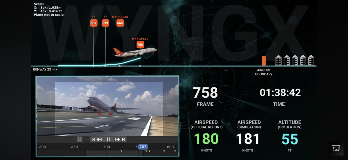
🚨 AI171 | RAT Deployment Before Fuel Cutoff — A Critical Clue
1️⃣
The simulation of Air India Flight AI171 (VT-ANB) perfectly matches the CCTV frame shown in the preliminary report.
Altitude ≈ 50 ft, Airspeed ≈ 180 knots, Time: 08:08:42 UTC.
At this point, the report notes — “fuel control switches transitioned to CUTOFF.”
But the CCTV shows something else. 👇
@MoCA_GoI @DGCAIndia #AAIB @SafetyMatters6 @NTSB
#AI171 #B787 #AviationSafety #AirIndia #HumanFactors #RAT #FlightData #ElectricalFailure #SafetyMattersFoundation @FAASafetyBrief @EASA @icao @aaibgovuk
4
12
59
11,420

22 Sep 2025
#CourtCorner | #AirIndia Crash PIL
SC agrees to hear PIL seeking independent probe into #AirIndia #AhmedabadCrash, issues notice to Centre, @DGCAIndia , AAIB on PIL
#PIL questions preliminary report suggesting pilot error, says one cryptic sentence in report on ‘fuel switch’ has cause speculation about pilot being suicidal
PIL seeks disclosure of #FlightData Recorder info, says we are no wiser on cause of crash
4
14
10,046

11 Sep 2025
@deradnet is democratizing aviation data. Researchers, drone delivery firms, drone logistics, and emergency responders gain access to reliable, historic and real-time flight data, all secured on Arweave and blockchain. Decentralized, permanent, transparent. #FlightData #Web3
2
42