
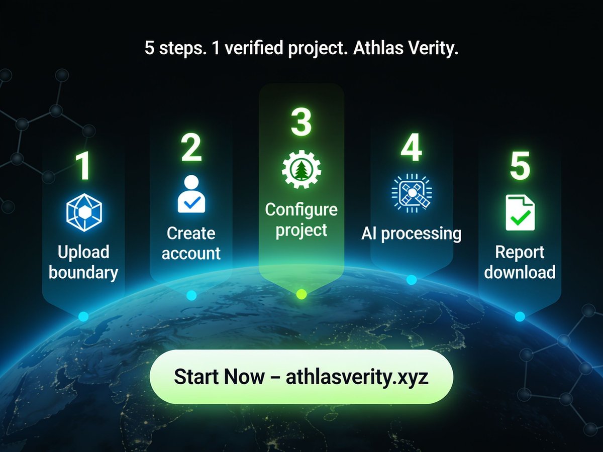
5 Steps to Your Own Amarora-Style Verification Report
Inspired by the Amarora Carbon Project? Here’s exactly how you can get the same quality verification for your carbon project using Athlas Verity.
Step 1: Prepare your project boundary.
Export your project area as GeoJSON, KML, or shapefile. Don’t have one? Use our built-in drawing tool on the platform.
Step 2: Create your Athlas Verity account.
Go to athlasverity.xyz/signup. No free trial currently, but affordable pay-as-you-go plans start at $0.25 per verified credit (minimum $99/month for small projects).
Step 3: Upload and configure.
Upload your boundary file. Select your project type (green carbon, blue carbon, renewable energy, or NBS hybrid). Choose your preferred methodologies (Verra, Gold Standard, IPCC, etc.). Our AI will suggest defaults based on your location and ecosystem.
Step 4: Let AI work.
Athlas Verity automatically pulls satellite imagery, runs biomass models, calculates carbon stocks, applies leakage and buffer deductions, and generates a waterfall calculation – just like Amarora’s.
Step 5: Download your verification report.
Within hours (or days for very large projects), you’ll receive a PDF report identical in rigor to Amarora’s – complete with geospatial verification, methodology references, and audit trail.
That’s it. No PhD in carbon accounting required. No months of waiting. No budget blowouts.
The carbon market is moving to dMRV. Move with it.
👉 Start your 5-step verification at athlasverity.xyz
@AmaroraCarbon @Verra @GoldStandard @ClimateTrade @CarbonDirect @WeAreCarbonCredits @MossEarth @CoolEffect @CarbonBetter @SouthPole_Group
#5Steps #CarbonVerification #AmaroraCarbon #AthlasVerity #dMRV #GetVerified #CarbonProject #ClimateAction #EasyMRV #JoinTheFuture
34

Has anyone used aguaceroWX for auto updating weather graphics on a website? I think you need a geoJSON but I dont know where to find that. Also, is there a way to have a logo on every graphic without having to re do it every time? @aguacerowx
2
207
地図ぼうけんラボ retweeted

Jun 9
\チャンミー(台風)の行方🌪️/
かなりアバウトなのはお許しください、、、
チャンミーの経路を
GeoJson Maker(geolonia.github.io/geojson-m…)で作成したどらせてみました👀
chizubouken-lab.jp/project/e…
#台風 #チャンミー #地図ぼうけんラボ
3
3
265

14h
New in GeoAlgeria 🇩🇿 - every civil airport in #Algeria, as data you can install.
33 airports across 31 wilayas: official names, ICAO codes, phones, websites, GPS, wilaya linkage. Straight from ANAC.
JSON · CSV · GeoJSON · TS · MIT
npm i @geoalgeria/aviation
1
11

18h
I am using my tool to find a place to live in SF using AI Agents
I hover over neighborhoods that give the right vibe, and Hermes by @NousResearch instantly knows where I'm pointing.
No copy-pasting coordinates, no describing anything.
SupaMaus saw I was on a map, read the center coordinates from the URL, turned what I drew into geojson, and handed it to the agent.
Then Hermes does the heavy lifting.
And that is the whole idea!
Your mouse pointer gestures are full of meaning. When you say "this," "here," "there," you're gesturing at something. SupaMaus captures that intent locally so an agent actually understands what you mean.
Working hard on getting all the bugs out with my buddy @BuildwithOmkarr .
Thanks for everyone who downloaded it!
I promise there is so much more coming. Watch me as we build it into the perfect harness which lives on your Mouse Pointer
Download link in the comments!
5
3
19
1,319


Jun 14
Got called out on TraceReady: "for a paid EUDR cleanup product, the proof doesn't carry enough weight — half the samples show no issues, so I can't even tell what it does."
Fair. Here's what changed:
→ First screen now shows ONE clear before/after: messy coffee/cocoa rows in, the exact blockers it catches, cleaned buyer pack out
→ Every sample (CSV, KML, GeoJSON) now surfaces real blockers — no more "no issues found" dead ends
→ Downloadable sample pack, clearly labeled a fictional fixture
→ A methodology page that says what TraceReady will never invent
The part I'm proudest of: zero fake proof. No invented testimonials, no fake order counts. Just inspectable output and a clear upgrade path once real permissioned customer proof exists.
Live: traceready.online
#buildinpublic #shiporDIE #EUDR #indiehackers #SaaS
20

Need the actual streets files OpenStreetMap .osm.pbf, can easily use OpenStreetMap JSON or GeoJSON for live navigations. How are you solving the switch between walking and driving (or other modes of transportation)? Fixed stops? Also have ways to solve stop optimization for switch between walking and driving. Because it’s Rust it can run in the browser (already live demo of that), or as part of Android or iOS app.
2
113

Jun 14
Made this with Fable 5 & Opus
Design your own Malaysian map 🇲🇾
Then download it FREE.
For devs and vibe coders building something with a Malaysia map, or designers who just want a clean one to drop into their work.
Export as SVG, GeoJSON, embed, or React component.
👉 maps.krackeddevs.com
9
20
178
8,474


GeoJSON overlay & local spatial data youtu.be/Y93BbSloXZU?si=DTX6… via @YouTube
26

Jun 13
This is so nice to play - tried to re route my paragliding flight's preview that I did today 🪂
Finally Google Earth supports uploading flight records like KML, GeoJSON. I've used several tracking apps in the past but none has such view so you can have irl like previews with best earth model.
Jun 12

Prepare for takeoff. ✈️ Flight simulator is now available globally on web to all users. goo.gle/4fBYnWO
We've recently added many our most powerful professional desktop features to web. Elevation profiles, new import types, but there's always been one other feature you've been asking us to add to the web version of Google Earth, just for fun...
Where will you fly? Share your best maneuvers, views, and flyovers with us!
4
607

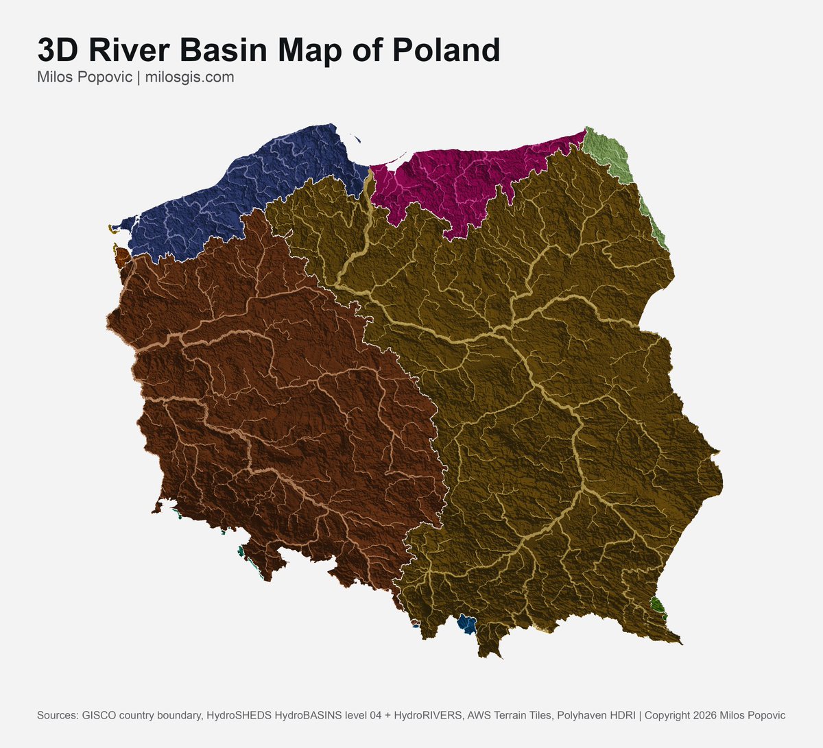
Built a 3D River Basin Map of India using this tool (forge3d)
Sample project (Poland):
github.com/milos-agathon/for…
India GeoJSON:
github.com/datameet/maps/blo…

May 6

Python🐍 can now render high-quality 3D river basin maps in seconds.
I built this map of Poland🇵🇱with forge3d to show how basins, rivers and terrain belong together: not as flat lines, but as water systems carved into the land.
Try forge3d 👉 github.com/milos-agathon/for…
1
4
29
2,618

Jun 13
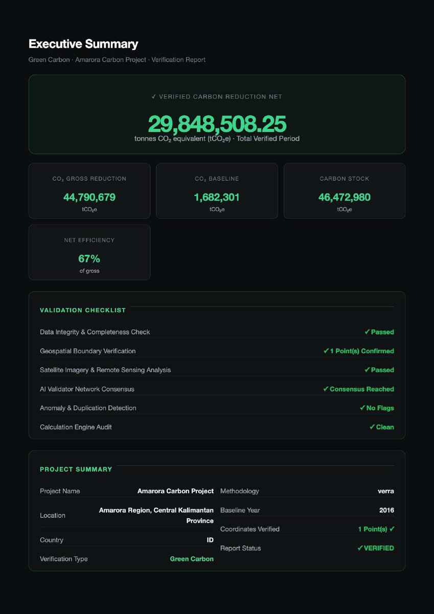
The Amarora Carbon Project Did It. Now It’s Your Turn.
The Amarora Carbon Project validation report is proof of concept. Proof that geospatial dMRV works. Proof that AI can handle complex carbon accounting at scale. Proof that a single project owner with a vision can get verified without a small army of consultants.
But here’s the most important part: Athlas Verity is open to everyone.
Forest project in the Amazon? Yes.
Mangrove restoration in Southeast Asia? Yes.
Soil carbon in the American Midwest? Yes.
Renewable energy in Africa? Yes.
The same engine that verified Amarora’s 93,461 hectares can verify your 500-hectare agroforestry plot. The same AI that computed 29.8 million tCO2e can compute your 10,000 tCO2e. The same transparency that earned buyer trust for Amarora can earn trust for you.
What you need to do:
Go to athlasverity.xyz
1. Create your account (no more free trial, but affordable plans start at $0.25/credit)
2. Upload your project boundary (GeoJSON, KML, or shapefile)
3. Let Athlas Verity run satellite analysis, AI scoring, and report generation
4. Download your verification report – just like Amarora’s
The carbon market is moving toward dMRV. Be on the right side of history.
👉 Start your verification journey at athlasverity.xyz
@AmaroraCarbon @Verra @GoldStandard @ClimateTrade @CarbonDirect @WeAreCarbonCredits @MossEarth @CoolEffect @CarbonBetter @SouthPole_Group
#YourTurn #AmaroraCarbon #VerifyNow #CarbonCredits #dMRV #AthlasVerity #ClimateAction #ProjectVerification #JoinTheMovement #CarbonMarkets


3
30

if there's an existing map on the web, I could probably pull the geojson out
1
36
