Aneeque Javaid retweeted

Jun 13
GeoLibre v1.2.0 is here!
GeoLibre is a free and open-source, lightweight, cloud-native GIS platform for visualizing, exploring, and analyzing geospatial data. One application that runs everywhere: in your web browser, as a native desktop app, on your phone, and inside a Jupyter notebook. No account, no server, no cost. Everything runs locally and your data stays private.
This release packs in 35 pull requests of new capabilities. A few highlights:
- Run SQL right in the browser. The SQL Workspace pairs DuckDB Spatial with a new in-browser PostGIS engine (PGlite), so you can query layers, local files, and remote URLs without a server.
- A smarter attribute table. Add fields, run a field calculator, and explore your data with a built-in Charts panel (histogram, scatter, bar, line, and box plots).
- More ways to add data. OpenStreetMap PBF extracts, Cloud-Optimized NetCDF/HDF via kerchunk, georeferenced video overlays, authenticated 3D Tiles, and a deck.gl Layer builder for custom overlays.
- Better visualization. Heatmap rendering, point clustering, and H3 hexagonal grids for spatial binning.
- New analysis and routing. A Directions plugin, plus Spatial Join, Select by Value, and Select by Location vector tools.
- Print and share. A print layout composer that exports your map to PNG or PDF.
- Work faster. A command palette (Ctrl/Cmd K), global keyboard shortcuts, and undo/redo for layer and style operations.
- Built for everyone. New internationalization framework, an accessibility pass with automated axe checks, an installable offline-capable PWA web build, React error boundaries, and Playwright end-to-end tests.
Try the live demo: viewer.geolibre.app
Star it on GitHub: github.com/opengeos/GeoLibre
Docs and roadmap: geolibre.app
Release notes: github.com/opengeos/GeoLibre…
#GIS #OpenSource #Geospatial #MapLibre #WebGIS #DuckDB #GeoLibre
9
102
657
33,715
pj retweeted

Just a reminder that our Native Senator who hates the oligarchs flies private.
334
2,866
17,551
286,691
Cherry’s Not Complying. retweeted

Does she let Sudanese men into her country that behead native citizens?
“I don’t think she does mate”

5
3
77
904
Arachnid retweeted

Ok everyone. This Native family from the U.S. has been having it very hard. They are also facing online harassment. They reached out for help with their phone bill & they need some food urgently. $300 USD needed. Please help. Let’s get them fed PayPal/etransfer tgtf1972@gmail.com
18
21
1,167
Clayhams retweeted

Don’t know the guy but these of course should be the bare minimums of any native European and their descendants.
13h

We didn't want to be vocal.
We didn't want to rise.
We simply wanted peaceful Sunday mornings..
There is nothing wrong with wanting to be around ones own people. Around those with similar beliefs, similar values, similar views.
Especially when those who are imported, and forced upon us, are so openly hostile towards us.
My entire life I have seen it pushed down everyone's throats that it is not okay to be white. You can have pride in ANYTHING and EVERYTHING except being white.
Wanna be proud to worship Satan? there is a week for that. LGBT? Gets a whole month. Every heritage and culture that is not white, gets weeks, and months to celebrate.
However being white and proud of it? Man oh man this is the most evil of evils.
We can not continue to care about their labels. We must protect our people. Our values. Our cultures.
If we do not stand and unite now. Our children will never have a chance. Never have a voice.
Our daughters will be used and abused, our sons sacrificed in the streets.
I for one will never be silent again. My daughter, My sons, their futures matter much more than these labels tossed around so freely.
1
1
10

25s
A good AI investment would be to become AI native as well. These tools are incredibly powerful and can genuinely be a wealth creator


Ya zalameh until when will we keep thinking it's possible to "negotiate" with any part of the system that ethnically cleansed the native population of the land they colonized? Just like they negotiated with Sitting Bull

I’ve said it before but the WHOLE of the Americas was a lot more black and native before the massive wave of euros came in the late 1800s/early 1900s, the Americas have only gotten whiter, they aren’t make more natives and Africans haven’t massed moved the Americas since colonial times

33s
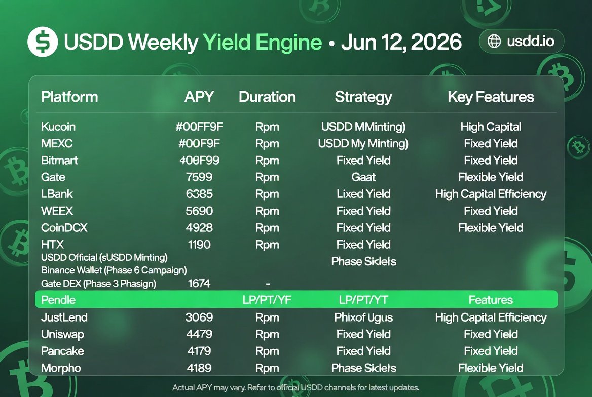
𝗜𝗡 𝗗𝗘𝗙𝗜, 𝗧𝗛𝗘 𝗕𝗜𝗚𝗚𝗘𝗦𝗧 𝗖𝗛𝗔𝗟𝗟𝗘𝗡𝗚𝗘 𝗜𝗦𝗡’𝗧 𝗙𝗜𝗡𝗗𝗜𝗡𝗚 𝗬𝗜𝗘𝗟𝗗 — 𝗜𝗧’𝗦 𝗦𝗨𝗦𝗧𝗔𝗜𝗡𝗔𝗕𝗟𝗘 𝗖𝗔𝗣𝗜𝗧𝗔𝗟 𝗨𝗧𝗜𝗟𝗜𝗭𝗔𝗧𝗜𝗢𝗡 💰🌐
In DeFi, the biggest challenge isn’t finding yield.
It’s finding sustainable yield without locking up your capital, chasing complex strategies, or constantly moving funds between protocols.
That’s where the growing USDD ecosystem stands out.
From simple earning products to advanced DeFi strategies, users now have multiple ways to put stablecoins to work based on their risk appetite and investment goals.
📈 𝗧𝗛𝗜𝗦 𝗪𝗘𝗘𝗞’𝗦 𝗢𝗣𝗣𝗢𝗥𝗧𝗨𝗡𝗜𝗧𝗜𝗘𝗦 𝗜𝗡𝗖𝗟𝗨𝗗𝗘:
🔹 Up to 7.94% APY via Binance Wallet Phase 6
🔹 Up to 7.82% APY through the Gate DEX Campaign
🔹 Pendle PT, YT, and LP strategies with fixed-yield and leveraged yield options
🔹 Native sUSDD yield generation
🔹 Additional earning opportunities across exchanges, wallets, and DeFi protocols
𝗪𝗛𝗬 𝗠𝗢𝗥𝗘 𝗨𝗦𝗘𝗥𝗦 𝗔𝗥𝗘 𝗣𝗔𝗬𝗜𝗡𝗚 𝗔𝗧𝗧𝗘𝗡𝗧𝗜𝗢𝗡
The shift is not just about yield — it’s about flexibility and capital efficiency.
✅ No deposit caps
✅ No lock-up periods
✅ 1:1 USDT ↔ USDD swaps with zero slippage via PSM
✅ Flexible strategies for both conservative and advanced users
✅ Expanding utility across TRON, Ethereum, and BNB Chain
𝗙𝗥𝗢𝗠 𝗦𝗧𝗔𝗧𝗜𝗖 𝗖𝗔𝗣𝗜𝗧𝗔𝗟 𝗧𝗢 𝗣𝗥𝗢𝗗𝗨𝗖𝗧𝗜𝗩𝗘 𝗖𝗔𝗣𝗜𝗧𝗔𝗟
Whether you’re targeting passive stablecoin income, fixed yield structures, or advanced DeFi positioning, the USDD ecosystem continues to expand the ways capital can stay productive.
Stablecoins no longer need to remain idle.
They can continuously work, adapt, and generate value across multiple strategies and platforms.
𝗙𝗜𝗡𝗔𝗟 𝗧𝗛𝗢𝗨𝗚𝗛𝗧
The future of DeFi is not just about higher APYs.
It’s about smarter capital design.
And ecosystems that reduce friction while increasing utility will define the next phase of stablecoin adoption.
@usddio @justinsuntron #USDD #sUSDD #DeFi #Stablecoin #YieldFarming #TRONEcoStar
1
V.O.C💔💔 retweeted

I’m almost certain you don’t know a single word in our actual native language, you look the type. Mad cause people don’t wanna speak another colonizers language is crazy
1
1
9
993


Many native Indonesian did see Japanese as liberator of colonial Dutch rule during WW2.
Same with the Malay in Malaya.
1

I also noticed they don’t force non-natives to put out RICU statements when a native does something to a minority.