
A @Reuters journalist covering commodities from New York. Former Brazil correspondent. Tips? marcelo.teixeira@reuters.com
Joined July 2009
- Tweets 11,494
- Following 689
- Followers 9,174
- Likes 1,710
1,876 Photos and videos

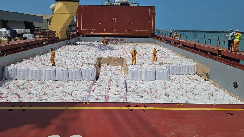


#Brazil #sugar exports in May fell 11.6% vs previous year to 1.97 mln tons, said the govt. I guess there was not much sugar left before the new harvest, and mills focused on ethanol at the start of crop. Anyway, significant decrease.
#trade #agriculture #shipping
3
7
39
14,958
A strong El Nino may be imminent. Climate change will make its effects worse reuters.com/sustainability/c…
5
563

May 30
India warns of weakest monsoon in 11 years, inflation risks rise - reuters.com/business/environ…
3
414
May 27
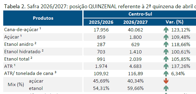
#Brazil mills crushed 40 million tons of sugarcane in the second half of April! Huge volume for that time of the year. The harvest started in a high tone, confirming reports of very good yields. #Sugar output 109% up, #ethanol production 105% up.
#agriculture
3
21
1,346
May 22
#Brazil #coffee
Consultancy @SafrasNews estimated BZL coffee harvest at 9% currently, vs 13% at this time last year. Cited some late maturing crops and also higher humidity.
#Agriculture #weather #Commodities
1
1
8
867
May 21
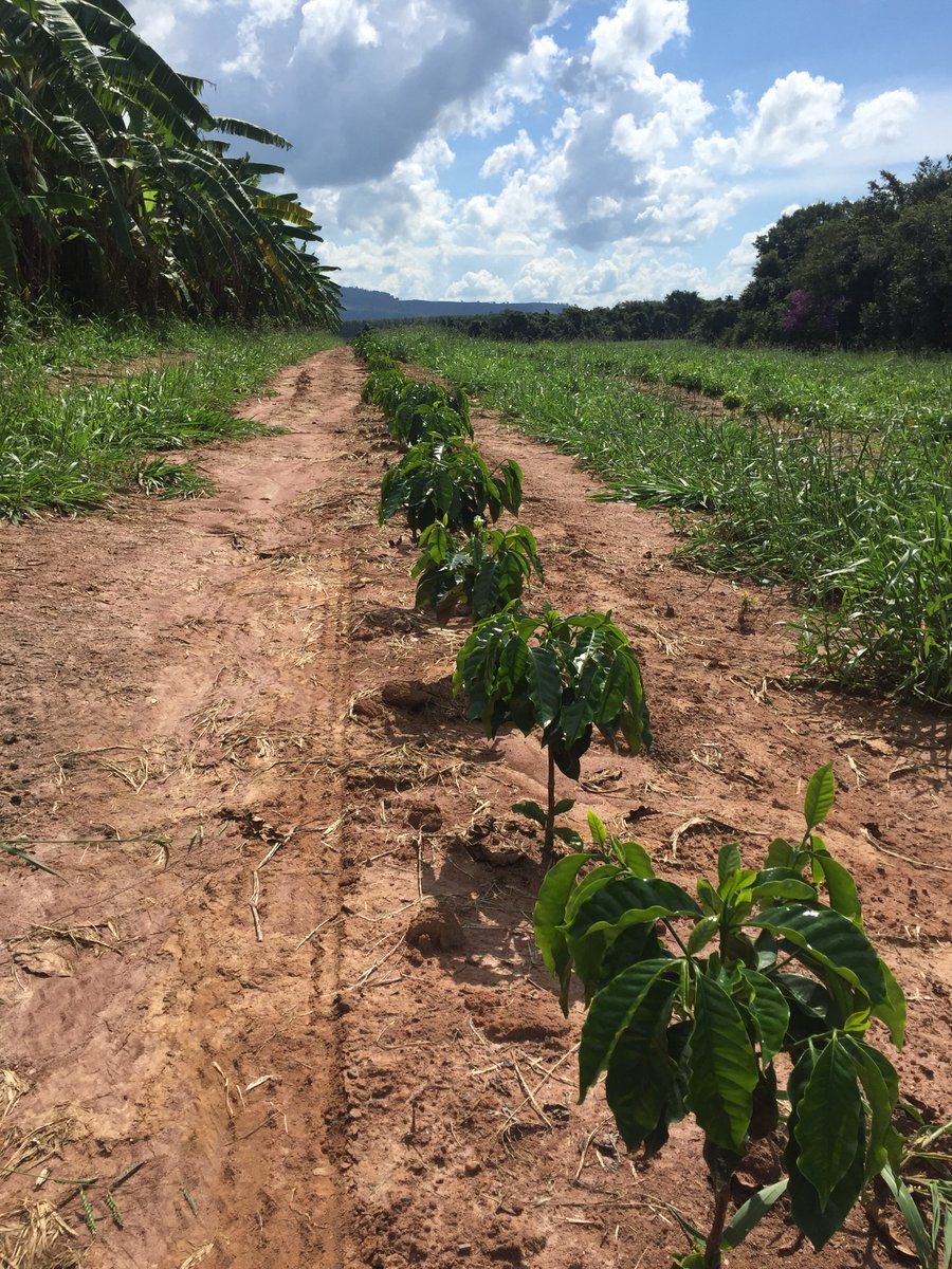
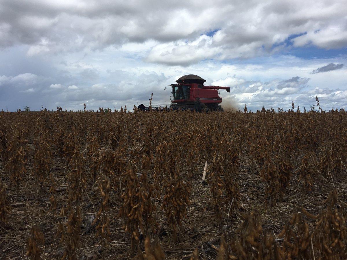
#Brazil's govt estimated that the area planted with #coffee in the country increased 3.9% in 2026 from last year to 2.34 mln hectares, or an increase of 86,900 hectares in a year. Below, young coffee trees in Sao Paulo state
#agriculture #softs
1
14
837
May 20
465
May 15
Too much going, and the group got bigger. No joint statement
reuters.com/world/china/indi…
1
353
May 15
#US, #Brazil see jump in #ethanol exports as consumers seek to boost #fuel supplies reuters.com/business/us-braz…
1
5
676
May 11
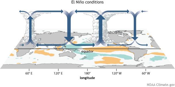
Ongoing debate among forecasters about how strong the next El Nino #weather anomaly could be. Some say initial data points to a very strong one
#agriculture #coffee #sugar #cocoa
May 10

El Niño is coming… and it could be a big one!
The Forecasted atmospheric response to the onset of El Niño looks very similar to what we saw in 1997-98.
There is a pretty subtle but significant difference between the 2026 forecast and 1997 though…
and that is the El Niño is being forecast to extend much further west into the Central Pacific than it did in 1997. If you look very closely you can see the green rising air is forecast to be much further west into the Pacific than it was in 1997.
If true, remember it still is just a forecast at this point, it would mean that the weather pattern we see in the US would not necessarily be the same weather pattern we saw in 1997-98.
So before you get carried away with “Winter is Over” talk here in May… just remember the positioning of these large scale atmospheric circulation cells (called Walker Cells) is very important with regard to precipitation patterns. If you’re in the part of the circulation cell that enhances upward motion, you’ll see more rainfall, however if you’re in a part of the circulation cell that enhances sinking motion, you’ll see less rainfall.
For example, during a typical El Niño pattern the sinking portion of a Walker cell is usually positioned over the Tropical Atlantic Ocean which tends to inhibit hurricane development.
~Meteorologist Mark Margavage
#wxtwitter #wxX #Tropicalwx


1
3
13
1,311
How China's evolving consumer habits may protect the Amazon rainforest - reuters.com/sustainability/b…
1
409
From @ReutersCommods: #BRAZIL 2025/26 SECOND #CORN PRODUCTION SEEN AT 112.1 MLN TNS VS 123.9 MLN TNS IN PREVIOUS CROP / BRAZIL 2025/26 TOTAL CORN PRODUCTION SEEN AT 140.5 MLN TNS VS 151 MLN TNS IN THE PREVIOUS CROP - AGROCONSULT
3
584
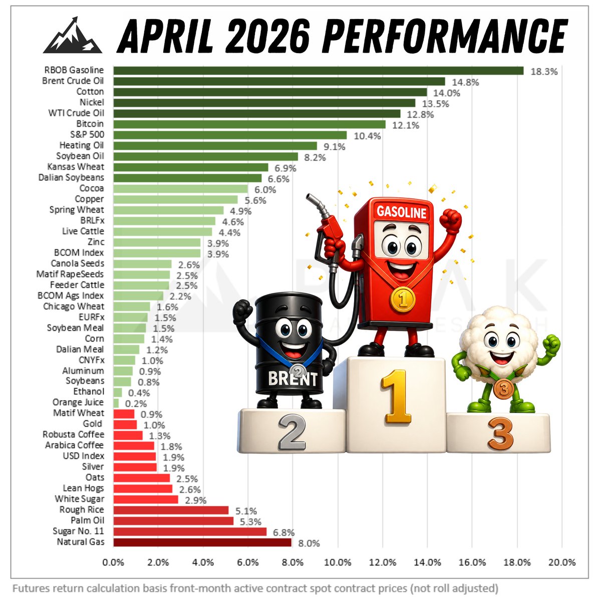
#Gasoline, #oil topping April performance, of course, but #cotton coming right after them with 14% gain. Some in the textile industry see opportunity for natural fibers as oil-based fibers become more scarce. Chart by @PeakTrading
#commodities #trading
7
701
Apr 28
More than 70% of #cocoa farmers in Ivory Coast have not bought #fertilizers for next crops reuters.com/business/environ…
3
10
823
Apr 28
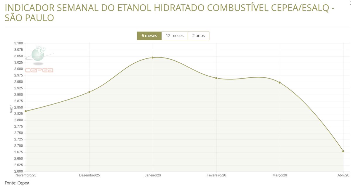
#Ethanol prices are falling in Sao Paulo, the largest consuming region for the fuel in #Brazil, says @CepeaEsalq, as the harvest of a near-record sugarcane crop progresses and state-controlled #oil company @petrobras keeps #gasoline prices unchanged
1
4
21
1,301
Apr 28
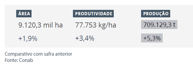
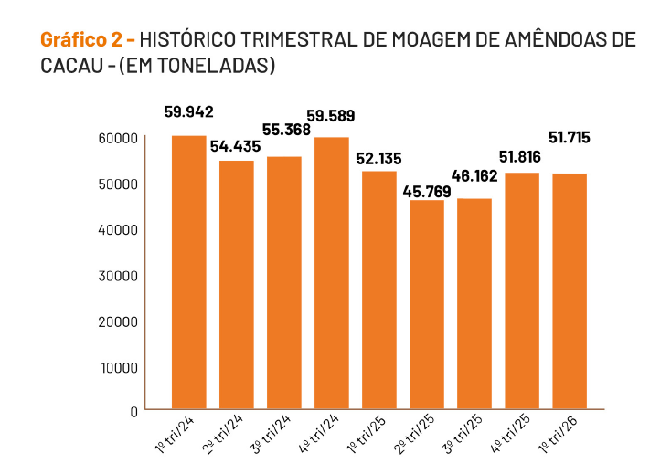
#Brazil's food supply agency @Conab_Oficial released its first projection for the new sugarcane crop. Brazil will produce more than 700 million tons of cane due to larger area, higher yields.
#agriculture #sugar #ethanol
4
6
20
2,068