
1,122 Photos and videos


普通に普段やってることに名前が付いた感

シリコンバレーで今、急速に注目されている職種がある。
営業でもない。
マーケターでもない。
エンジニアでもない。
その全部をAIでやる「GTMエンジニア」。昔は10人で回していた営業・マーケ・オペレーションを1人で設計する。その知られざる実態をこちらにまとめました👇
blog.btrax.com/jp/gtm-engine…
1
3
1,857

今井翔太 retweeted

Jun 13
fable5使えなくなったからもう休み! って人今日多そう.もう酒呑むしかないこの時代.
65
158
1,828
300,349
今井翔太 retweeted

Jun 13
Wow, product visualization via Gaussian Splatting is mind blowing. 🤯
From @Blender to @lichtfeldstudio , the details are crazy. It preserved everything so well, even the tiny hairs on the fabric! I honestly can't stop looking at it.
500pics, 50k iterations, 2mil splats, IGS
8
21
260
25,232

今井翔太 retweeted

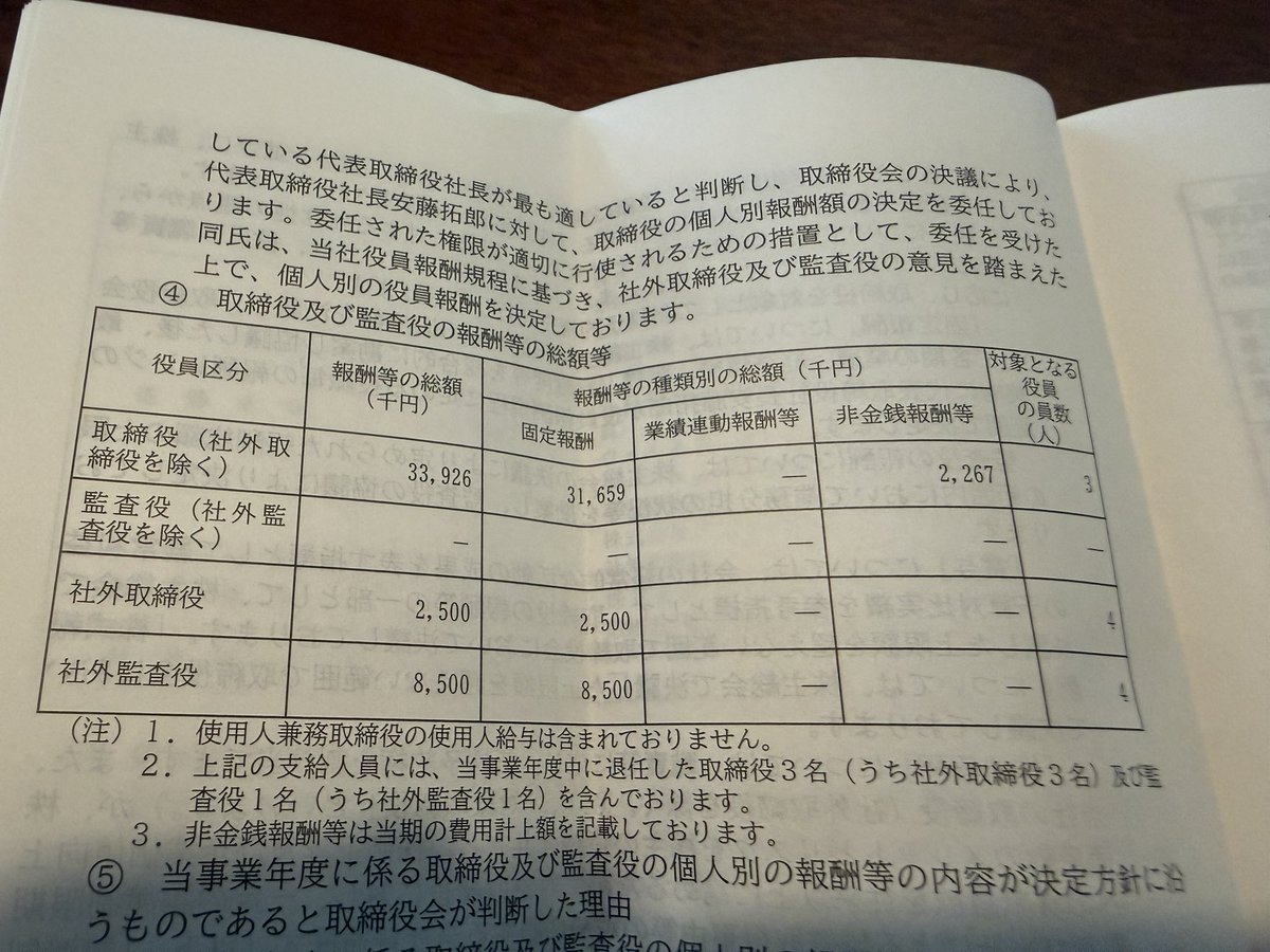
TORICOの役員報酬 ショボすぎて笑うwww
社外取は4人で年額250万円ってことは1人平均にすると年60万ちょい!? 月5万円!?
まあ業績と株価にお似合いだぜ
@hkunimitsu @takuroando


12
8
64
38,667
やっぱりアメリカ製品に依存するのはリスクでしかないよね。
Jun 13

The US government, citing national security authorities, has issued an export control directive to suspend all access to Fable 5 and Mythos 5 by any foreign national, whether inside or outside the United States, including foreign national Anthropic employees.
The net effect of this order is that we must abruptly disable Fable 5 and Mythos 5 for all our customers to ensure compliance.
Access to all other Claude models is not affected.
We apologize for this disruption to our customers. We believe this is a misunderstanding and are working to restore access as soon as possible.
Read our full statement: anthropic.com/news/fable-myt…
8
2,351
今井翔太 retweeted

Jun 12
100回でも言う。飛び込みで行ったらイキりスーツ着たヤツに「銀行なんかいらねえんだよ」と吐き捨てられたクールジャパン。税金入れてんだからここの無能な投資判断したヤツら本気で消えてほしい。
クールジャパン機構廃止案 検討へ
#Yahooニュース
news.yahoo.co.jp/pickup/6584…
26
120
1,301
285,233
今井翔太 retweeted

Jun 12
Prepare for takeoff. ✈️ Flight simulator is now available globally on web to all users. goo.gle/4fBYnWO
We've recently added many our most powerful professional desktop features to web. Elevation profiles, new import types, but there's always been one other feature you've been asking us to add to the web version of Google Earth, just for fun...
Where will you fly? Share your best maneuvers, views, and flyovers with us!
439
3,936
30,763
8,901,867
Teams使う利点って何?未だに仲良くなれてないツールの一つ。


3
2,895


今井翔太 retweeted

Jun 11
GeoLibre v1.1 is out!
GeoLibre is a free and open-source, lightweight, cloud-native GIS platform for visualizing, exploring, and analyzing geospatial data. One application that runs everywhere: in your web browser, as a native desktop app, on your phone, and inside a Jupyter notebook. No account, no server, no cost. Everything runs locally and your data stays private.
This release builds on the v1.0 foundation with features that make day-to-day mapping smoother:
- Attribute table management — rename, delete, hide/show, and reorder fields right in the table, with the layout saved to your project.
- Data-driven symbology for Add Vector Layer — single, categorized, graduated, and expression-based styling now applies to maplibre-gl-vector layers.
- Atmosphere Effects plugin — a deep-space backdrop, parallax starfield, comets, and a glowing globe halo at low zoom (toggle it from the Controls menu).
- Layer panel upgrades — rename layers, open the attribute table, and export straight from the layer actions menu.
- Auto Refresh extended to Add Vector Layer URL layers.
- In-browser GeoPandas via Pyodide — run the vector tools with no Python sidecar, same results.
- Plugin API — external plugins can now render on the host's shared deck.gl instance via app.getDeckGL().
Try the live demo: viewer.geolibre.app
Star it on GitHub: github.com/opengeos/GeoLibre
Docs and roadmap: geolibre.app
Release notes: github.com/opengeos/GeoLibre…
#GIS #OpenSource #Geospatial #MapLibre #WebGIS #DuckDB #GeoLibre
13
76
502
19,374
今井翔太 retweeted

Jun 11
We're training the next version of Composer... with Composer!
The model is always learning from itself. This kind of "recursive self-improvement" might sound new, but it's been happening for many months!
For example, training big models requires creating *lots* of data for RL - essentially games the model plays to improve at any task you can grade.
The newest models can configure their own environments to make those games playable (auto-installing dependencies, fixing broken setups).
Composer 2 was *dramatically* better at this than version 1. So the better the model gets, the better it gets at creating the conditions to train its successor.
Each generation unlocks capabilities the previous one didn't have! So cool.
x.com/cursor_ai/status/20521…
May 6

We use previous generations of Composer to train future ones.
Our autoinstall system has earlier Composer models set up dev environments for RL training. That way, the next generation can focus on learning to solve harder problems.
cursor.com/blog/bootstrappin…
130
101
2,201
193,937
今井翔太 retweeted

Jun 10
i have no words..
asked claude fable 5 to recreate one of the most creative threejs experiments from @Amin_Ankward
here’s the wild result..
11 Mar 2025

it's time to style the moss industry 🪴🍄
more exploration of interactive (conceptual) elements for web design with ThreeJS
it works via geonodes and is based on basic math and proximity functions, I think I'm going to keep making concepts like that
20
50
979
187,403
今井翔太 retweeted

Jun 10
Fable one shotted the game logic.
GPT Image 2 for designs.
Blender MCP for models lighting.
Total dev time ~6 hours.

Introducing Claude Fable 5: a Mythos-class model that we’ve made safe for general use.
Its capabilities exceed those of any model we’ve ever made generally available.
82
162
2,954
315,004
今井翔太 retweeted

Jun 10
Every time a new model drops, someone says designers are dead. Fable 5 is the biggest one yet.
So I gave it the @LottieFiles Creator MCP and asked it to animate. Real Lottie, one prompt, runs in production.
Does this kill motion designers, or finally put it in everyone's hands?
15
18
244
35,256