
Joined August 2007
- Tweets 40,002
- Following 918
- Followers 2,444
- Likes 87,999
12,299 Photos and videos


New mesoscale discussion just dropped
“SUMMARY...Potential for extreme rates and localized totals of 6" likely to induce incidents of flash flooding through this afternoon”

#WPC_MD 0418 affecting Southeast Texas...Southwest Louisiana..., #lawx #txwx, wpc.ncep.noaa.gov/metwatch/m…

1
9
520
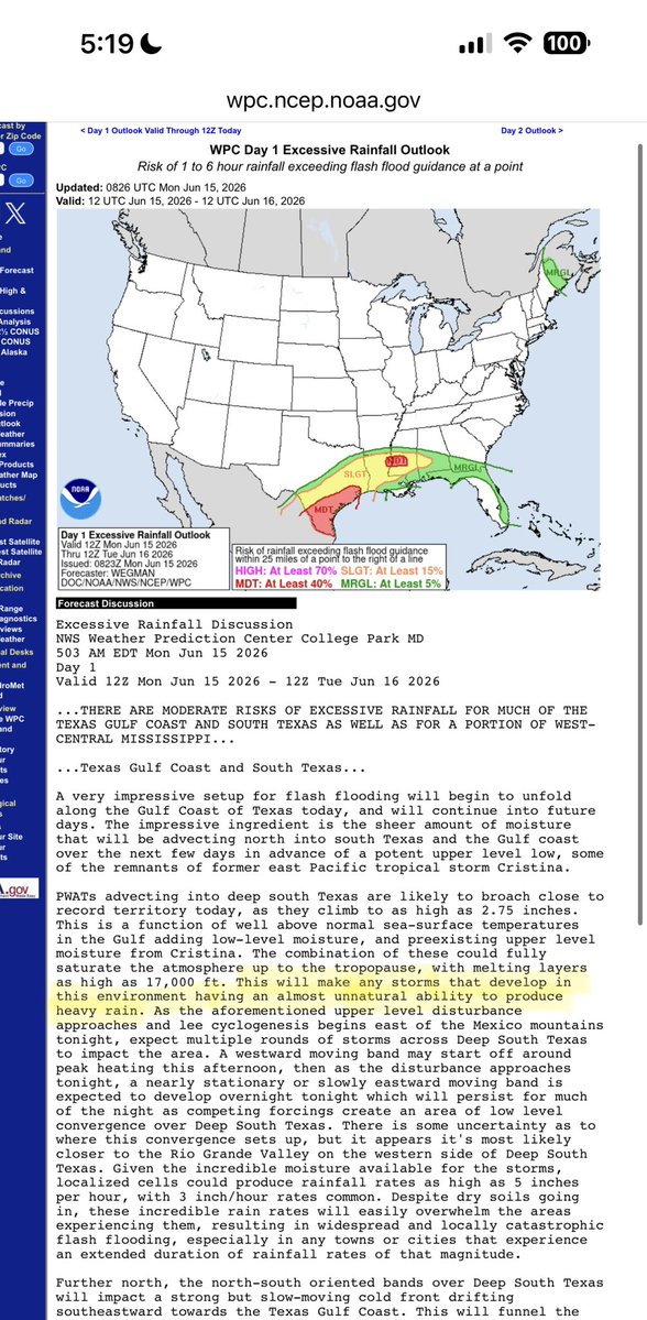
Some very interesting language (highlighted in yellow in pic) from @NWSWPC in their Day 1 Excessive Rainfall Outlook today.
“This will make any storms that develop in this environment having an almost unnatural ability to produce heavy rain.”
True link: wpc.ncep.noaa.gov/qpf/ero.ph…
A MODERATE risk is in effect in our Day 1 Excessive Rainfall Outlook. More details: go.usa.gov/cu3Dw

1
3
9
1,603
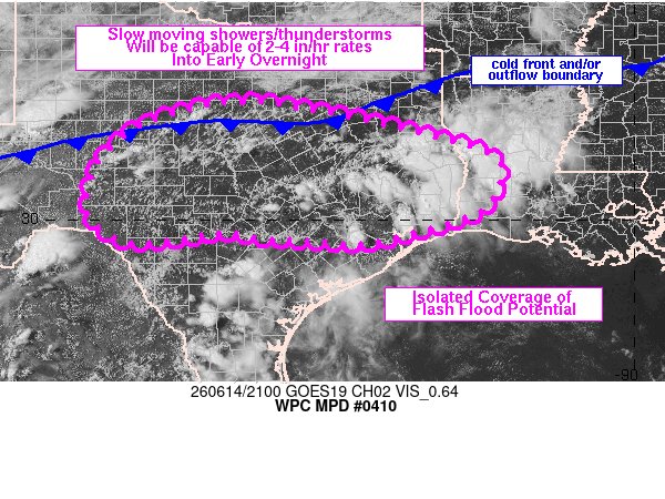
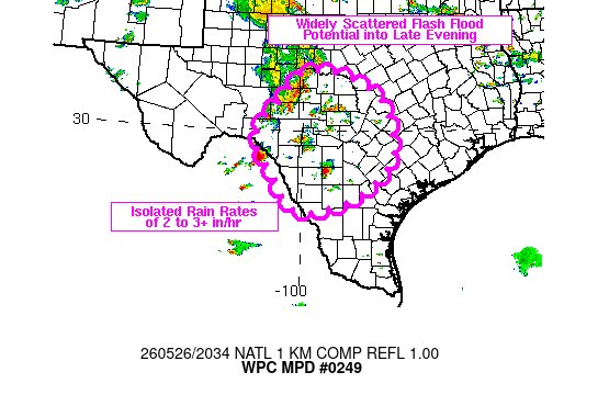
“Summary... scattered hvy rain w/high rates will pose an isolated flash flood risk from the Edwards Plateau to SE TX/W LA. Lack of cell org & focus is expected to limit the coverage of impacts, which will perhaps be greatest across urban or otherwise flood prone locations.”
#WPC_MD 0410 affecting west-central to eastern TX/western LA, #lawx #txwx, wpc.ncep.noaa.gov/metwatch/m…
1
2
383
Billy Forney 3 retweeted

Jun 13
From @OptaSTATS: Yordan Alvarez is the first player in MLB history to have:
multiple homers
a grand slam
6 RBI
...all in the first inning of a game.
8
170
1,228
35,492

Jun 9
A real beauty just flew over this cuckoo’s nest here in Houston Heights at 11:35am, @houstonairw
5
1
12
1,060
Billy Forney 3 retweeted

Jun 1
Since today is the official start of the 2026 Hurricane Season, we want to remind you to be prepared. Make sure you assemble a disaster supply kit, and make a written plan now. Check out weather.gov/hgx/hurricanegui… for our 2026 hurricane guide! #TXwx 🌀

1
7
10
2,105
Billy Forney 3 retweeted

May 27
It's 29th anniversary of the Jarrell, TX F5 Tornado.
Still one of the most fascinating atypical tornado formation processes ever documented.
Extreme CAPE w/ No Shear Favorable Boundary Interactions Back-building mergers = Landspout-turned-F5 Grinder
13
99
802
42,528
Billy Forney 3 retweeted

6
25
4,608
Billy Forney 3 retweeted

From 2000 to 2020, the center of population of the Houston MSA moved a remarkable 2.9 miles northwest, one of the largest shifts of any US metro area. If trends have continued it's possible the center of population has crossed the Inner Loop (I-610) by 2026.

24
64
517
89,892
Billy Forney 3 retweeted

May 23
The MKT Bridge is open right on time for summer!! Happy Memorial Day weekend!
👀why did it take 480 days tho
10
20
197
19,358

Lightning bolts from storms south of I-10 are making their way to Aggieland. Be safe! @NWSHouston #txwx
1
2
11
2,165

Billy Forney 3 retweeted

May 20
Low end hurricane status here in Georgetown right now @KristenCurrieTV @averytomascowx @WilliamsonCOSWx @TravisCOSW @TxStormChasers
10
24
149
14,005

Billy Forney 3 retweeted

May 11
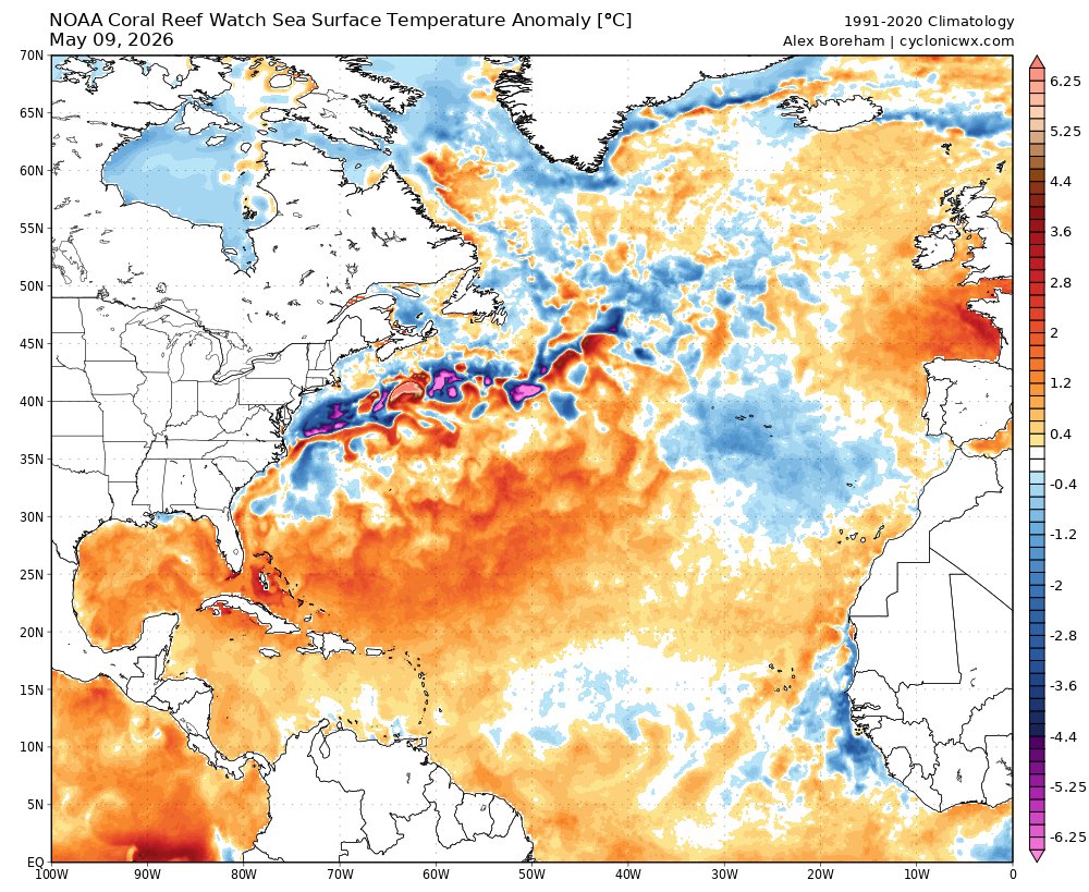
Let’s take a pulse check on the Atlantic and El Niño, as we’re now 3 weeks away from the start of hurricane season. substack.com/home/post/p-197…
3
3
19
4,192
Billy Forney 3 retweeted
May 11
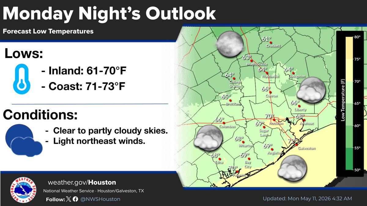
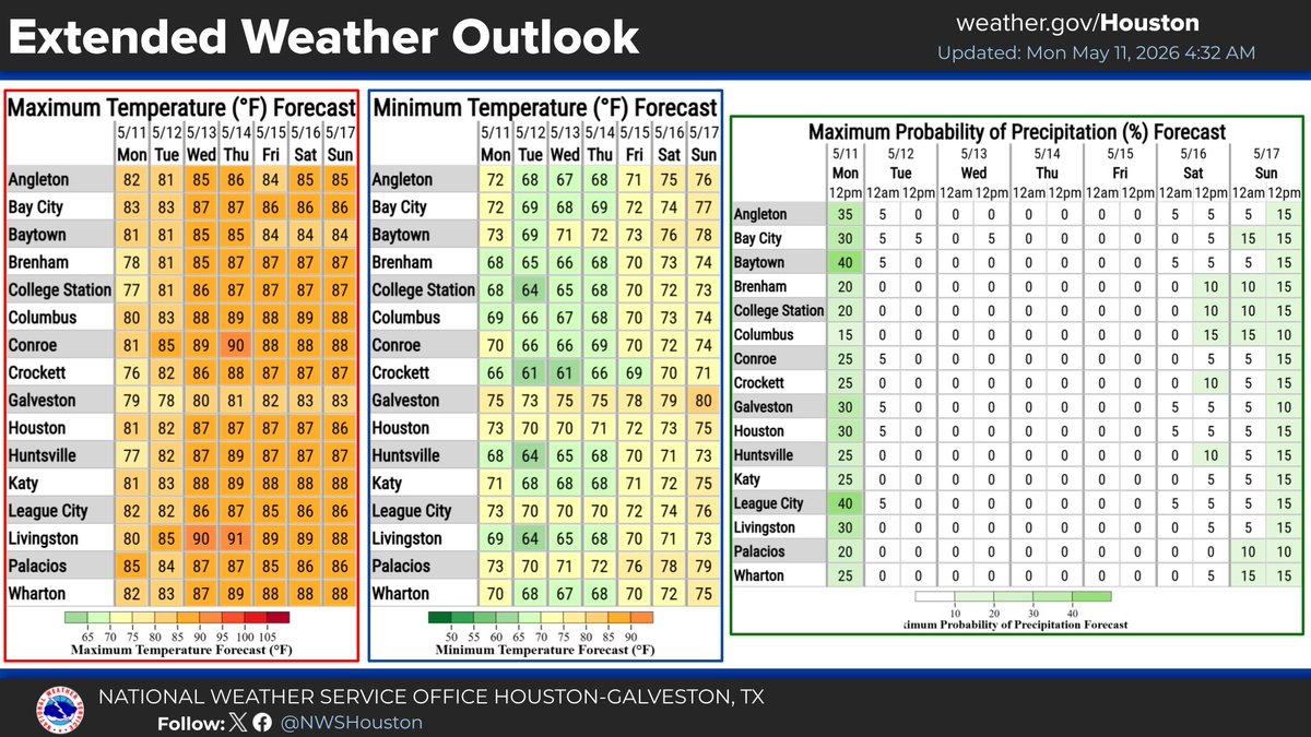
Good morning! After a night of showers and storms, we will see conditions improving today.
The rest of the week is expected to remain tranquil but warmer.

1
6
20
2,703
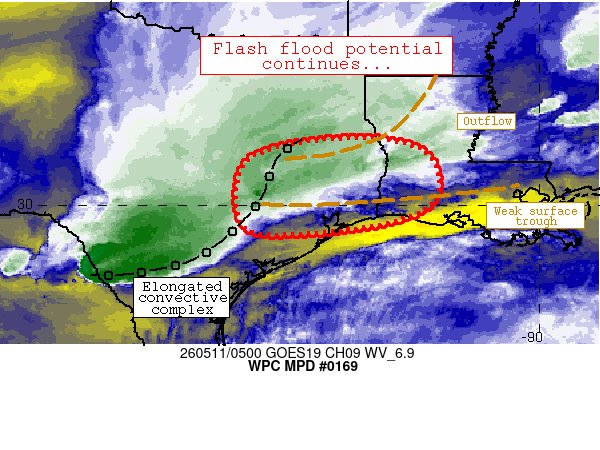
May 11
Summary...Flash flood potential will continue for at least 2-3 more hours (through 08Z/3a central).
#WPC_MD 0169 affecting central/east Texas into far western Louisiana, #lawx #txwx, wpc.ncep.noaa.gov/metwatch/m…
1
222
May 9
SUMMARY...A conditional risk for isolated large hail and damaging wind gusts exists across portions of southeast Texas this afternoon.


196
Billy Forney 3 retweeted
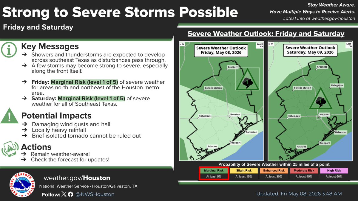
May 8
A few rounds of showers & thunderstorms will develop over Southeast TX today & Saturday. Some storms may become strong to severe, capable of producing damaging winds & hail. Brief isolated tornado cannot be ruled out.
Make sure to have multiple ways of receiving warnings.
1
12
21
3,082
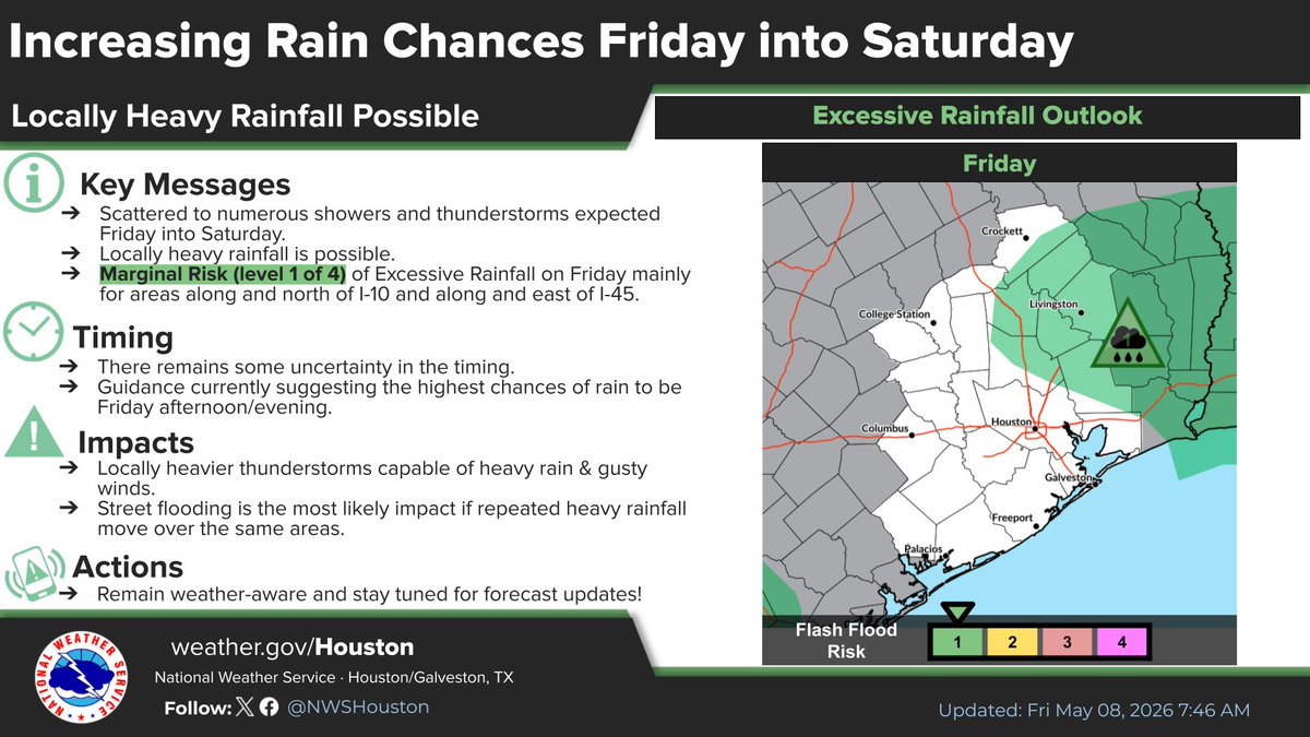
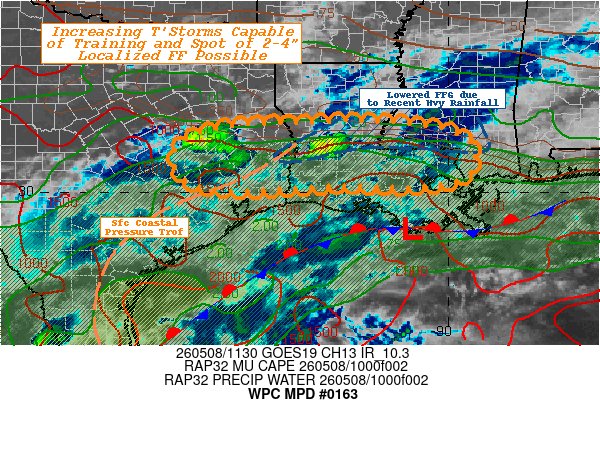
May 8
Primary area outlined here is in Montgomery County just north of Houston and Harris County.
“SUMMARY...Early morning elevated thunderstorms with potential to train this morning pose narrow axis of 2-4" totals and isolated flash flooding concerns near urban and areas of recent heavy rainfall.”
#WPC_MD 0163 affecting Southeast Texas...Southern Louisiana...Southwest Mississippi..., #mswx #lawx #txwx, wpc.ncep.noaa.gov/metwatch/m…
159