
Cartographer and Principal Technical Consultant @Esri / cache slinger / early adopter / data wrangler / quoter of movies bc I lack original thoughts of my own
Joined September 2017
- Tweets 2,268
- Following 258
- Followers 815
- Likes 6,120
800 Photos and videos


Pinned Tweet

9 Feb 2018
Daughter dropped some news on me last night: *Dad I told my class I want to make maps when I grow up. Can I make maps like you?* Sweetheart, you will make amazing maps if that’s what you want to do. Buckle up world another #Cartographer on the way. #ProudDaddy #YouGoGirl ❤️
2
1
25
Tommy 🗺️ retweeted

28 Nov 2025
Five years in Jordan left Jared Kohler fascinated with its rare national flower, the Black Iris. Incorporating ArcGIS Living Atlas iNaturalist GBIF data in #ArcGISPro, he mapped recorded sightings across the country.
#30DayMapChallenge day 28: ow.ly/ZCBq50Xz8mw

2
27
1,512
Tommy 🗺️ retweeted
22 Nov 2025
Tommy Fauvell built a road map of the U.S. AND a reusable #ArcGISPro project to help you fully leverage the Natural Earth public domain map dataset. Explore it for yourself today!
#30DayMapChallenge day 22: ow.ly/rkou50XwgvM


2
4
20
1,880
Tommy 🗺️ retweeted
21 Nov 2025
That’s a wrap on the #30DayMapChallenge week 3!
This week, the #ArcGISPro Team showcased the keystone role prairie dogs play in shaping ecosystems, projected… projections, explored the many ways trees are stylized in @Esri basemaps more!
Get a recap here:ow.ly/qevO50XvZWU
1
5
35
1,720
Tommy 🗺️ retweeted
21 Nov 2025
From forests to trees, features are uniquely visualized across the different @Esri basemaps. Using #ArcGISPro, Cindy Prostak mapped ways trees are symbolized. 🌳Take a “walk” and marvel at the distinctive foliage.🚶♀️
#30DayMapChallenge day 21: ow.ly/mRQL50XvNVZ

10
49
1,955
Tommy 🗺️ retweeted
20 Nov 2025
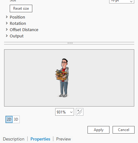
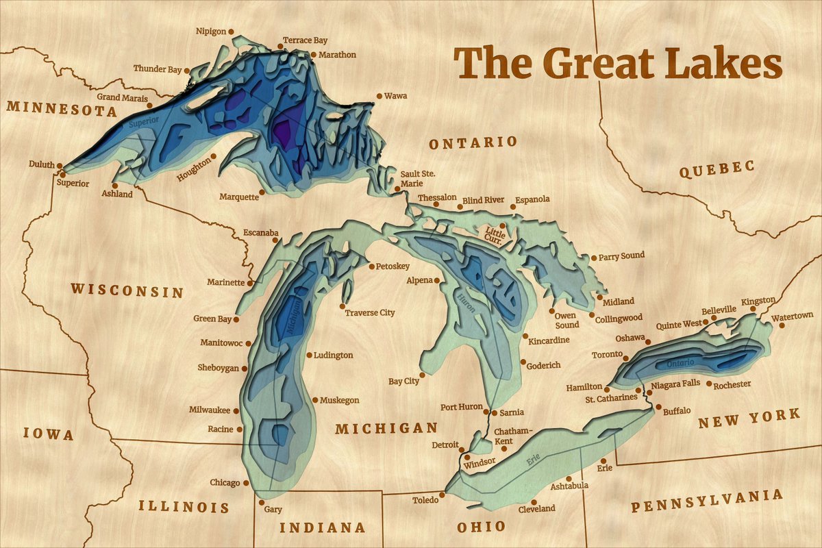
🌊 Wooden lake maps are a classic Midwest cabin decor, often showing bathymetry in thin layers of wood. 🪵 Noel Peterson crafted 2D &3D digital representations of these in #ArcGISPro!
Check out day 20 of the #30DayMapChallenge: ow.ly/irNB50XuMBX

13
56
2,145
Tommy 🗺️ retweeted
7 Nov 2025
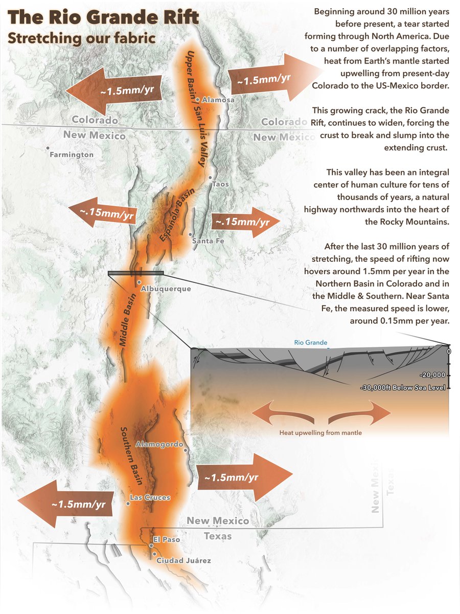
Map accessibility conversations often stop at contrast ratios and text sizes. Jakob Ruffner created this Rio Grande Rift map to demonstrate that the key is to consider every aspect of the map design process.
Check out day 7 of the #30DayMapChallenge: ow.ly/VU1X50Xo6wa
1
13
81
2,848
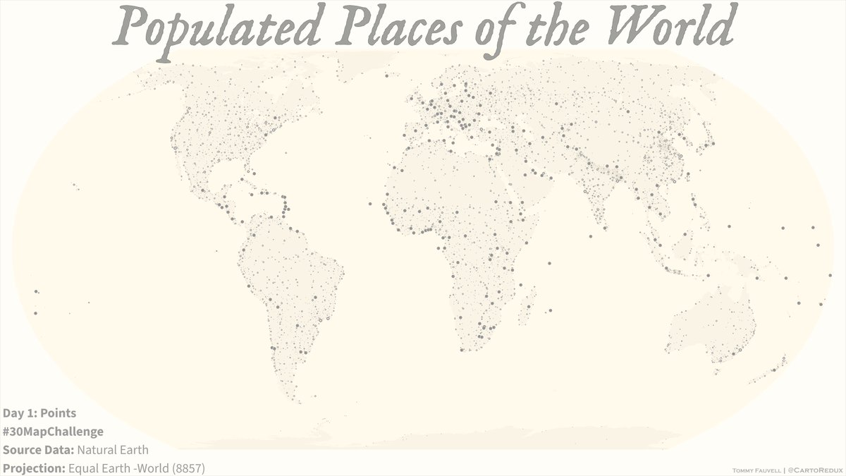
7 Nov 2025
Here goes...few days behind already 😅
#30DayMapChallenge Day 1: Points - Populated Places of the World using Natural Earth data. #BuiltWithArcGISPro @ArcGISPro
more details over here: blog.cartoredux.net/2025/11/…
11
458
28 Mar 2025
Behind every great battle hardened 1:50 TLM map there was a PFC or SPC that wrestled with laminating it on the hood of a HMMWV...
28 Mar 2025

#MarinesAndMaps. Laying it all out! @1stMarDivision Marine uses maps to plan route for exercise to integrate with joint and naval forces.

ALT Photograph of a Marine lying on a map on the ground, while pointing to another map. Another Marine kneels and looks on. (Photo Credit: Cpl. Grant Schirmer, 1st Marine Division; modified by the Army Geospatial Center)
169
Tommy 🗺️ retweeted

9 May 2024
We're back with another ArcGIS #StoryMaps Shorts — our new video series.
Today, tackle map vignettes with @WarrenDz. 🔊
Check out the growing playlist here: esri.social/StQc50RAl5O
1
5
29
3,949
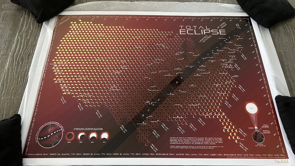
8 Apr 2024
Not really sure much more is getting done today. Will be pouring over this gorgeous creation by @kennethfield with my family for the rest of the afternoon. 😎
#Eclipse2024 #GoldFoil
8 Apr 2024

I love making digital maps. But there’s just something special about being able to hold a map. The feel of it, the smell of the ink…

2
439
8 Apr 2024
Goodies arrived just in time! I didn’t think they made bottles this tall and thin @kennethfield 🍻
1
1
258
8 Apr 2024
I love making digital maps. But there’s just something special about being able to hold a map. The feel of it, the smell of the ink…
2
1
7
1,350
Tommy 🗺️ retweeted

8 Apr 2024
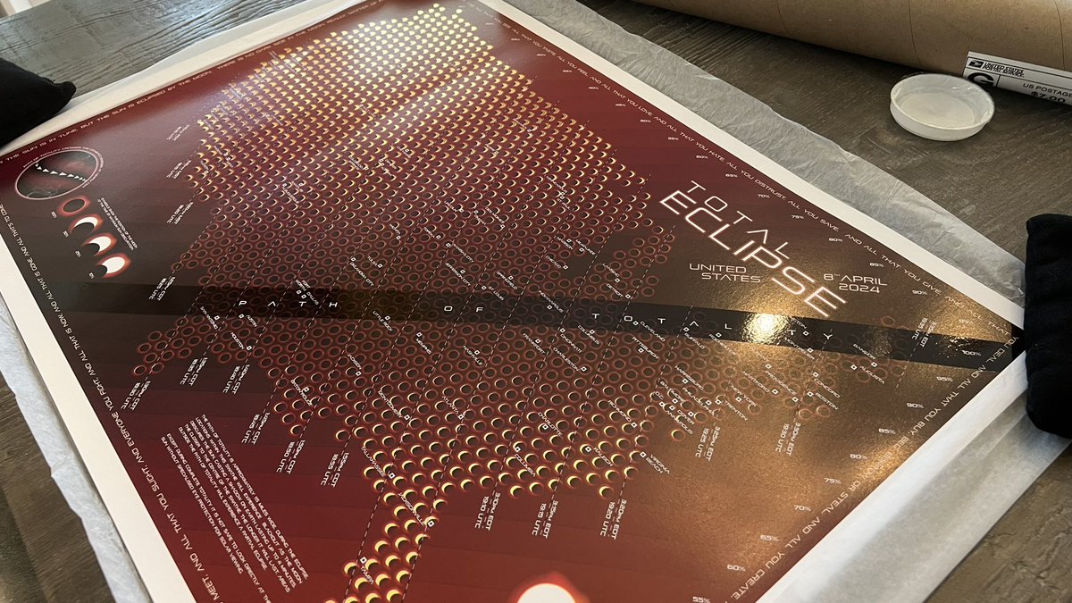
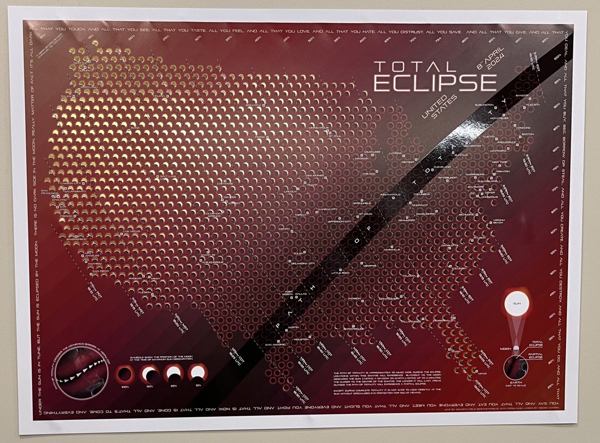
It's #Eclipseday. Celebrate with my map showing the dance of the sun and moon wherever you are in the contiguous U.S.
Download your free map here: carto.maps.arcgis.com/home/i…
Limited shiny gold foil print giveaways to come.
#Eclipse2024 #TotalEclipse2024

2
7
25
5,869
Tommy 🗺️ retweeted

30 Jan 2024
This water fill pattern is <chef’s kiss>

Explore one of the earliest extant examples of Thai cartography, an 8-foot-long cloth map - or really two maps, one on each side - in our latest blog post, From the Mountains to the Mekong.
Read it here: blogs.loc.gov/maps/2024/01/f…
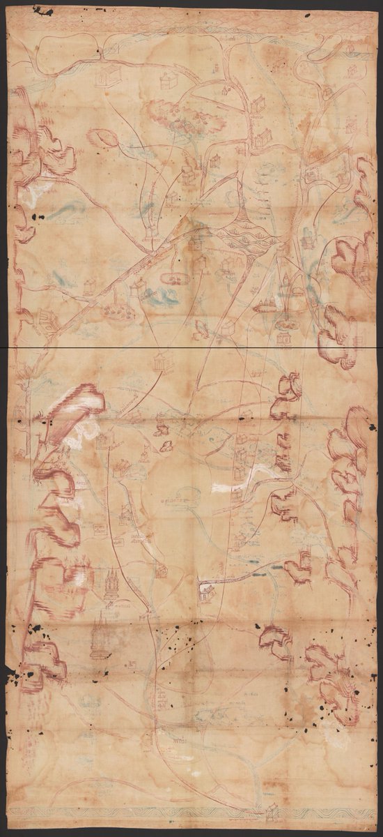
ALT Cloth manuscript map in red ink showing mountains, rivers and canals, roads, towns, buildings, and text in Thai
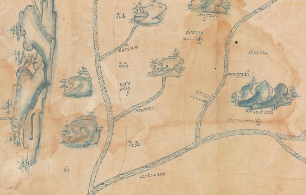
ALT Detail of Thai cloth map in blue ink showing mountains, rivers, and text labels
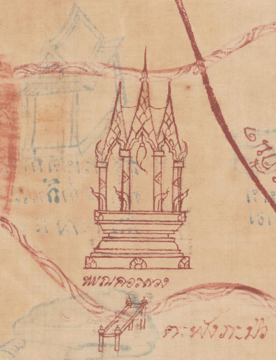
ALT Detail of Thai cloth map showing a building and bridge in red ink; blue ink shows through from the other side
2
17
2,495
Tommy 🗺️ retweeted
1 Feb 2024
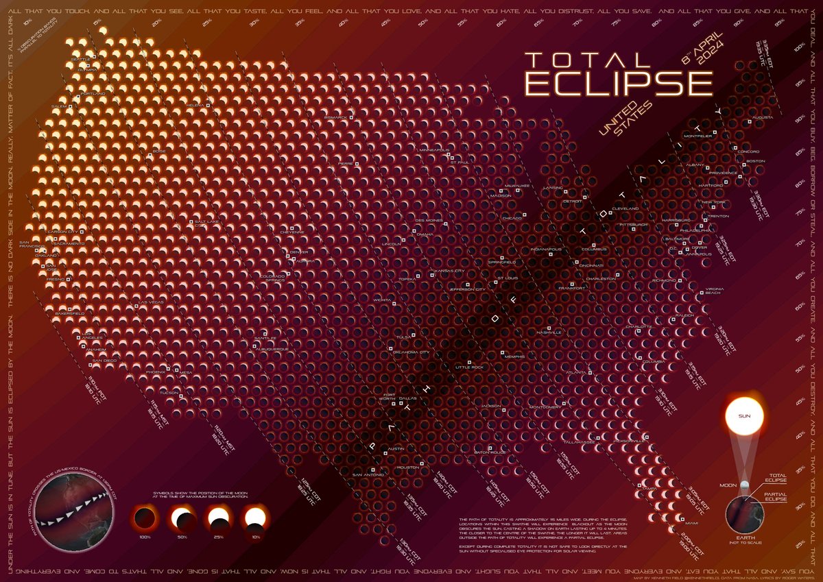
Total Eclipse: new map by me showing the time, obscuration, and appearance of the eclipse for over 1,500 locations across the US in readiness for April 8th.
Hi-res download: carto.maps.arcgis.com/home/i…
Blog: esri.com/arcgis-blog/product…
#totaleclipse #eclipse #eclipse2024 #sun #moon
12
29
150
19,423
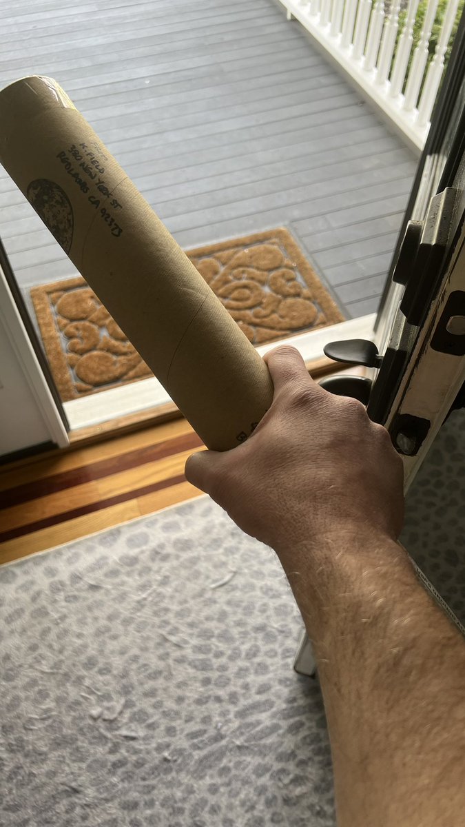
20 Dec 2023
Thanks @kennethfield! Luckily I found a responsible adult to receive this early Christmas delivery 🎄
☑️ Plans for the evening locked in
Want the back story on how this bottle came to land on my doorstep? Check this out 👇🏻
esri.com/arcgis-blog/product…
1
5
299
Tommy 🗺️ retweeted
14 Dec 2023
I made a #map or two, and wrote a blog about how to make them yourself in ArcGIS Pro. There's holly and owls too. esri.com/arcgis-blog/product… #Christmas #HappyHolidays #cartography

4
31
3,259
Tommy 🗺️ retweeted
8 Dec 2023
Been working on a cheeky little map 'thing' with @CartoRedux. How-to and 'what on earth is the point?' next week but here's a taster for what's left of Friday...
1
18
2,258
Tommy 🗺️ retweeted

17 Oct 2023
I've spent the last decade telling stories with maps, through maps, and of maps. A new chapter begins today.
@MapsDotCom is live! 🔥
Maps.com is designed from the ground up to share the power and joy of cartography with the world.
#maps #dataviz #geography
4
37
213
26,670