Emmy winning meteorologist @wafb from Long Island, NY. Met degree from Penn State. AMS/NWA seals. Happily married and proud father. Worked in SATX, HOU.
No...this isn't somewhere up north! This is Lafayette, Louisiana, getting near blizzard conditions as they are under a Blizzard Warning! Baton Rouge NOT under that warning, but still a Winter Storm Warning. 4-8 inches expected. wafb.com?utm_medium=social&u…
A Flood (FA) Advisory has been issued for the following parishes/counties until 6/16 7:15PM: East Baton Rouge, Livingston, Pointe Coupee, Iberville, East Feliciana, St. Helena, West Baton Rouge, West Feliciana. Turn around, don't drown! #lawx#mswx
A Flash Flood Warning has been issued for the following parishes/counties until 6/16 5:15PM: East Baton Rouge, Livingston, Pointe Coupee, Iberville, West Baton Rouge. Turn around, don't drown! #lawx#mswx
A Flash Flood Warning has been issued for the following parishes/counties until 6/16 7:00PM: East Baton Rouge, Livingston, Pointe Coupee, Iberville, West Baton Rouge. Turn around, don't drown! #lawx#mswx
A Flood (FA) Advisory has been issued for the following parishes/counties until 6/16 6:00PM: Assumption, Lafourche, St. James. Turn around, don't drown! #lawx#mswx
A Flash Flood Warning has been issued for the following parishes/counties until 6/16 4:45PM: Tangipahoa, Washington, Pearl River, Walthall. Turn around, don't drown! #lawx#mswx
A Flash Flood Warning has been issued for the following parishes/counties until 6/16 5:15PM: East Baton Rouge, Livingston, West Baton Rouge, Iberville, Pointe Coupee, Ascension, St. Helena. Turn around, don't drown! #lawx#mswx
A Flash Flood Warning has been issued for the following parishes/counties until 6/16 3:15PM: East Feliciana, Pointe Coupee, Tangipahoa, West Feliciana, St. Helena, Pike, Amite, East Baton Rouge, Walthall, Washington, Wilkinson. Turn around, don't drown! #lawx#mswx
A Flash Flood Warning has been issued for the following parishes/counties until 6/16 2:45PM: Tangipahoa, Washington, Pearl River, Walthall. Turn around, don't drown! #lawx#mswx
A Flash Flood Warning has been issued for the following parishes/counties until 6/16 1:45PM: St. John The Baptist, St. James, Assumption, Ascension, Iberville, Lafourche. Turn around, don't drown! #lawx#mswx
NHC has initiated advisories on Potential Tropical Cyclone One (formerly AL90) located over southern Texas. Potential Tropical Cyclone Advisories (PTC Advisories) are issued when there is high confidence that the disturbance will develop into a storm and bring significant impacts.
Potentially life-threatening flash and urban flooding is possible across the Texas coast eastward into central Mississippi through Thursday. Prolonged rainfall may extend the flood threat into the weekend. Widespread small stream and minor river flooding is expected along the Texas coast into southwest Louisiana, with isolated areas of significant river flooding possible across the Texas Coast and Louisiana.
Potential Tropical Cyclone One is forecast to become a tropical storm as it moves along or just off the northwestern Gulf coast through Wednesday. Tropical Storm Watches have been issued from Sargent, Texas, to Morgan City, Louisiana.
Minor to moderate coastal flooding is expected along portions of the Upper Texas and Louisiana coastlines.
hurricanes.gov
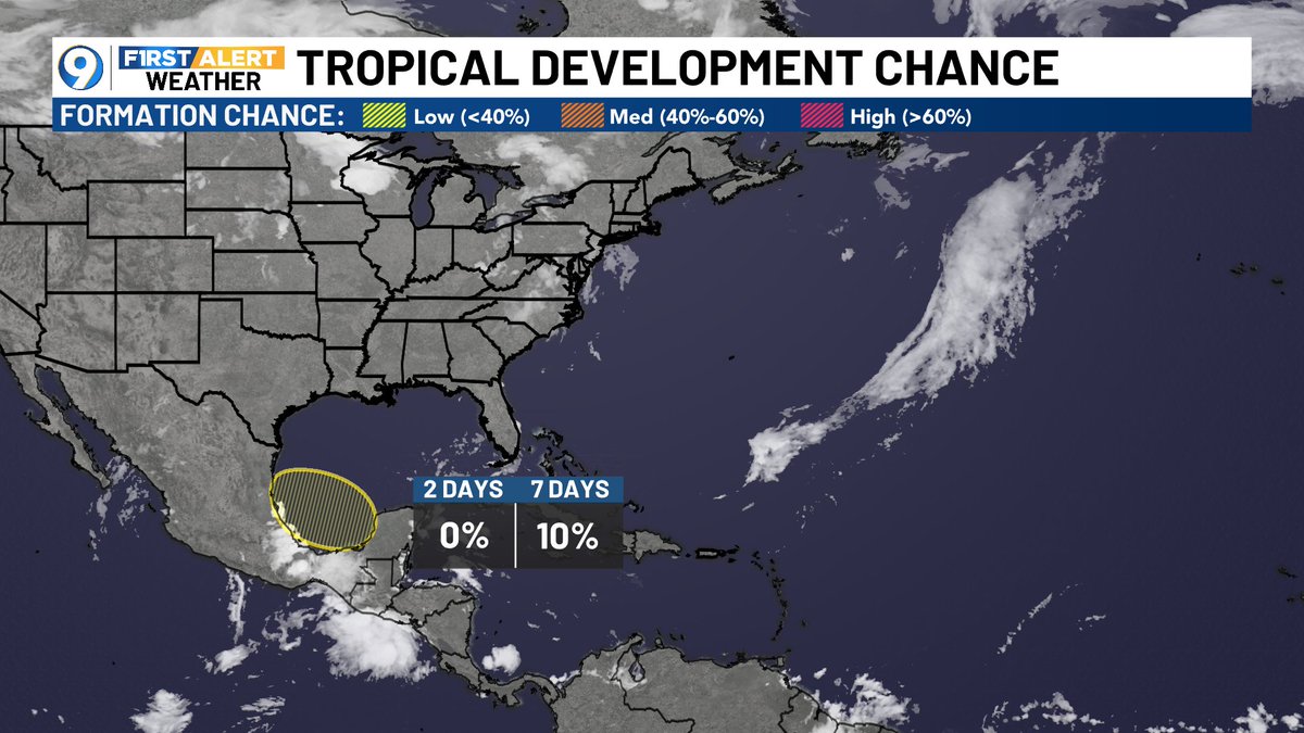
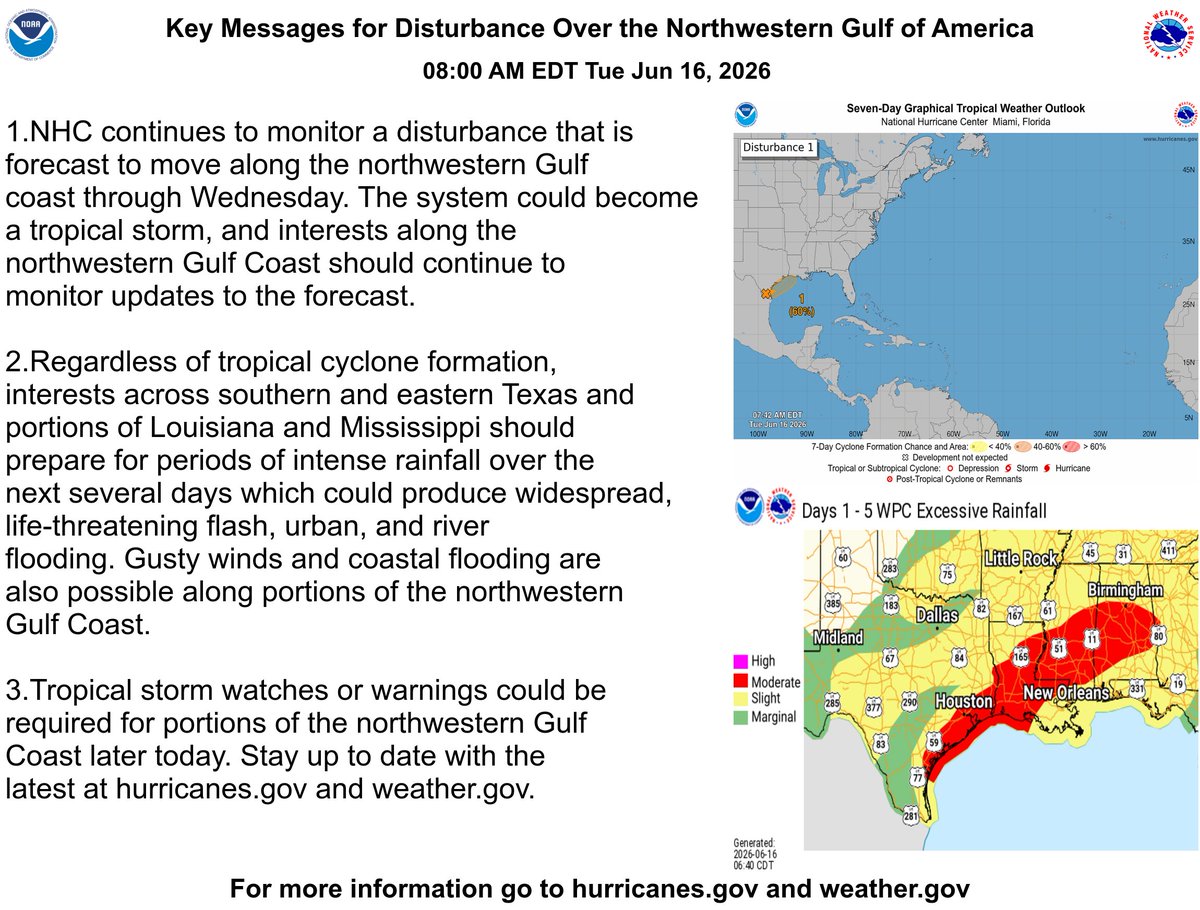
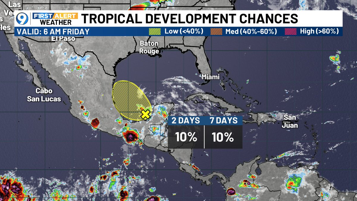
ALT National Hurricane Center forecast map for Potential Tropical Cyclone One, issued June 16, 2026. The system is centered in the western Gulf of Mexico near the Texas-Mexico border and is forecast to move northeast toward the upper Texas and Louisiana coast through Thursday. The forecast track shows gradual strengthening, becoming a tropical storm by Tuesday evening and Wednesday, then potentially reaching depression strength inland over Louisiana by Thursday morning. A Tropical Storm Watch is in effect for portions of the Texas and Louisiana coastline. Main concerns include tropical storm conditions, heavy rainfall, and coastal impacts along the northwestern Gulf Coast.
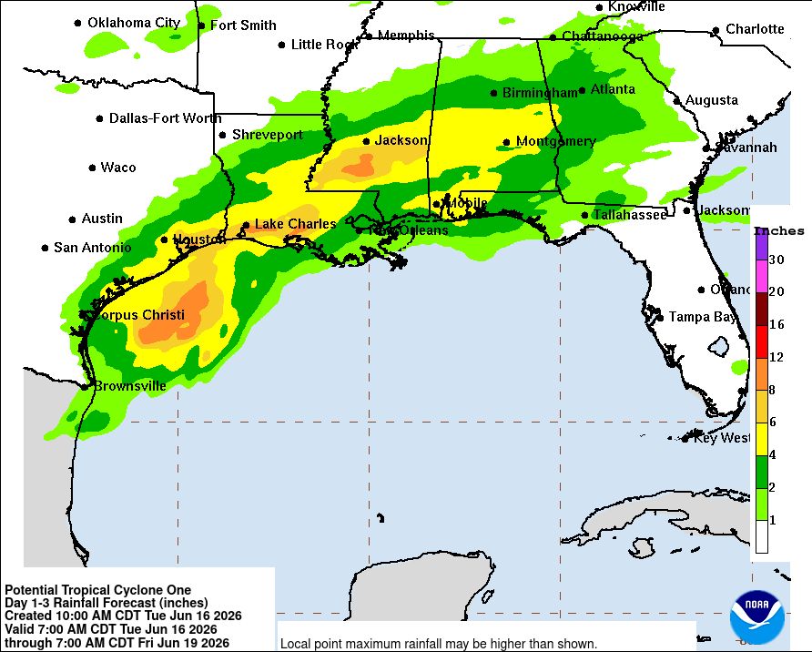
ALT NOAA rainfall forecast map showing expected precipitation totals from Potential Tropical Cyclone One from Tuesday, June 16 through Friday, June 19, 2026. The heaviest rainfall is forecast across south and southeast Texas, especially between Corpus Christi and Brownsville, where 6 to 12 inches or more are possible. A broad corridor of 2 to 6 inches extends northeast through Houston, southwest Louisiana, southern Mississippi, Alabama, and the Florida Panhandle. Lower rainfall totals extend farther inland across the central Gulf Coast. Main hazards include flash flooding, urban flooding, and isolated river flooding, especially in southern Texas where the greatest rainfall is expected.
A Flood (FA) Advisory has been issued for the following parishes/counties until 6/16 12:45PM: Assumption, Lafourche, St. James. Turn around, don't drown! #lawx#mswx
Jun 16 8am EDT: Key Messages for the Disturbance Over the Northwestern Gulf of America. Stay up to date with the latest at hurricanes.gov and weather.gov
Don't be nervous about the new yellow area in the Gulf...Even though it looks different than before, we're still not expecting a favorable environment for tropical development as it remains at only 10%. This feature will combine with a cool front next week to produce more rain.
Are you tired of the heat? Some good news on that front, as a cool front will move into our area next week, Monday/Tuesday. This front will combine with leftover moisture from the remnants of Cristina moving into the Gulf. A level two slight risk of excessive rain Mon thru Wed.
El Niño conditions are present and expected to strengthen into the Northern Hemisphere winter 2026-27. An #ElNino Advisory is now in effect. #ENSOcpc.ncep.noaa.gov/products/a…
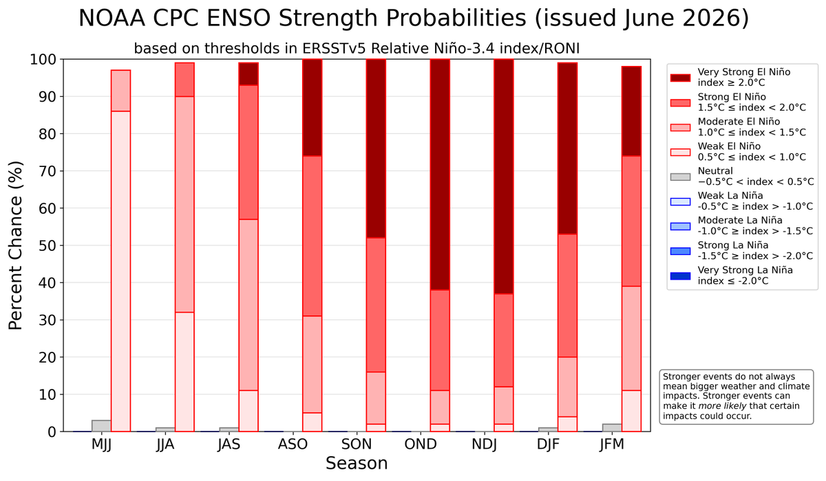
ALT A bar chart showing the chance of El Niño (red bars), ENSO-Neutral (grey bars), and La Niña (blue bars) provided for 9 upcoming, overlapping 3-month seasons (each letter represents a month, for example, F = February). The color shading within the bars indicates the chances of different categories of El Niño or La Niña strength (weak, moderate, strong, and very strong). Alternatively, the table at the internet address below presents the percent chances of each strength category in numerical form. https://cpc.ncep.noaa.gov/products/analysis_monitoring/enso/roni/strengths/