Weather, environment and critter reporter for USA Today Florida. Certificate in Weather Forecasting, Penn State. Surfer, dog walker. University of Arizona.
First Invest of the season. Invest 90 is designated over Mexico and looks to spend most it's time over land heading eastbound towards the Atlantic. Very unique for sure. Latest EURO/GFS ensembles here on tropicaltidbits.com. Pressure under 1000mb could mean some storms to go along with the heavy rain already expected.
The Asian swamp eel may be worse for Florida than Burmese pythons as it decimates the food chain from the bottom up. palmbeachpost.com/story/news… via @pbpost
As the 2026 Atlantic hurricane season begins, NHC Director Dr. Michael Brennan shares an important message about hurricane preparedness.
Learn more at hurricanes.gov and noaa.gov/hurricane-prep
It's the first day of hurricane season. Prepare for the social media hype. How the National Hurricane Center is fighting storm misinformation on its own social media channels palmbeachpost.com/story/weat… via @pbpost
Back already? I guess we had a few months reprieve from #iguanas after the freeze. Just enough for my plants to recover so they’ll have plenty to eat. 😕
Models often "spin up" systems at far out time ranges (7 days in the future) that never materialize. Beware of posts that share a specific single model run for clickbait and opt for reliable sources instead.
As always, we will be here with you throughout the upcoming season.
5/21: A signal for near *record* moisture late this month could result in likely above normal precipitation across South Florida.
The Climate Prediction Center highlights a high (60-70%) chance of this occurring. It's too early to identify specific locations & rainfall totals.
Reminder ahead of Memorial Day weekend: Swimming in a pool is NOT the same as swimming at a beach with crashing waves, winds, and dangerous currents.
You should be a strong swimmer before you go into the ocean. Learning how to swim is the best defense against drowning.
More tips at weather.gov/safety/beach
World Cup in Miami spikes worry over extreme fans in extreme weather. Hurricane season, thunderstorms, dangerous heat....what could go wrong? palmbeachpost.com/story/weat… via @pbpost
🌀Tropical Weather Outlooks return on May 15th ⌛
👀TWOs describe disturbances with a potential for tropical cyclone formation. Learn more about them using this graphic and at hurricanes.gov.
Staying informed is the first step to staying safe! ✅
#PRwx#USVIwx
ALT lt Text: A vertical educational infographic titled “2-Day & 7-Day Graphical Tropical Weather Outlooks. What do they mean?” divided into four sections.
Section 1 (Overview): Explains that Graphical TWOs describe significant areas of disturbed weather and their potential for development into a tropical cyclone. They are NOT a track forecast. Includes an example of a 7-day TWO.
Section 2 (Color-Coded Formation Chance): Color-coded Xs are disturbances (e.g., tropical waves) that the National Hurricane Center (NHC) is monitoring. The shaded areas are where these disturbances could develop into a tropical cyclone. There are four categories: Gray (Development not expected), Yellow (Low chance <40%), Orange (Medium chance 40–60%), and Red (High chance >60%).
Section 3 (Current Systems): Current Tropical, Subtropical, Post-Tropical Cyclones or Remnants also mentioned.
Section 4 (Issuance Time): Issued by the NHC from May 15th to Nov 30th at 2 AM, 8 AM, 2 PM and 8 PM AST or when necessary.
🌀Las Perspectivas sobre las Condiciones del Tiempo en el Trópico regresan el 15 de mayo ⌛
👀Estas perspectivas describen disturbios con un potencial de convertirse en ciclones tropicales. Infórmate sobre ellas con esta gráfica y en hurricanes.gov.
#PRwx#USVIwx
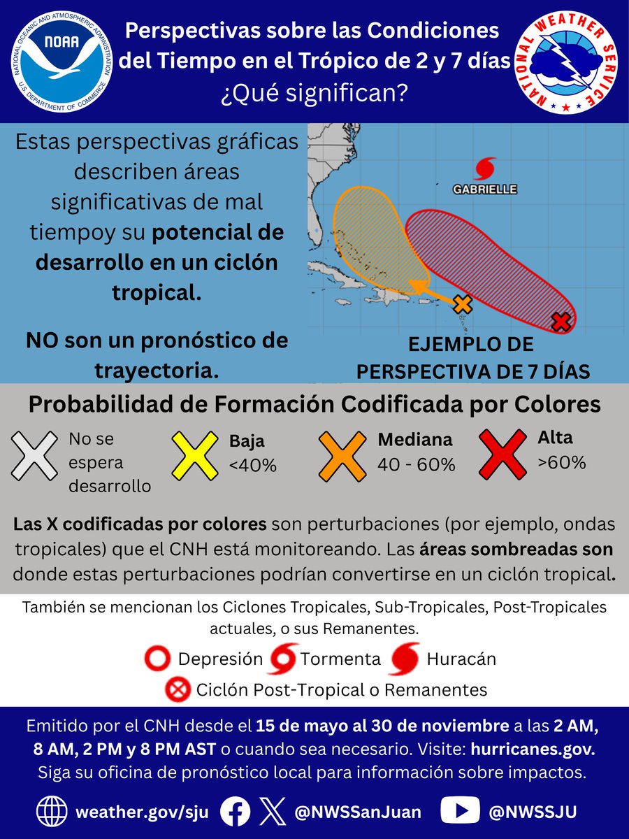
ALT “Perspectivas sobre las Condiciones del Tiempo en el Trópico de 2 y 7 días. ¿Qué significan?” dividida en cuatro secciones.
Sección 1: Explica que estas perspectivas gráficas describen áreas significativas de mal tiempoy su potencial de desarrollo en un ciclón tropical. NO son un pronóstico de trayectoria. Incluye un ejemplo de una perspectiva de 7 días.
Sección 2: Las X codificadas por colores son perturbaciones (por ejemplo, ondas tropicales) que el CNH está monitoreando. Las áreas sombreadas son donde estas perturbaciones podrían convertirse en un ciclón tropical. Hay cuatro categorías: Gris (No se espera desarrollo), Amarillo (Probabilidad baja <40%), Naranja (mediana 40–60%) y Rojo (alta >60%).
Sección 3: También se mencionan los Ciclones Tropicales, Sub-Tropicales, Post-Tropicales actuales, o sus Remanentes.
Sección 4: Emitido por el CNH desde el 15 de mayo al 30 de noviembre a las 2 AM, 8 AM, 2 PM y 8 PM AST o cuando sea necesario.
Hundreds of beagles bred for medical research saved by Big Dog Ranch in Florida. Rescue highlights shift away from animal testing by FDA. palmbeachpost.com/story/news… via @pbpost
12:13pm CDT #SPC Day2 Outlook Slight Risk: for far southern Georgia eastern Florida Panhandle into North and Central Florida spc.noaa.gov/products/outloo…