Aviso de Tormenta Severa incluye Ogden UT, Layton UT, Roy UT hasta las 12:45 PM MDT
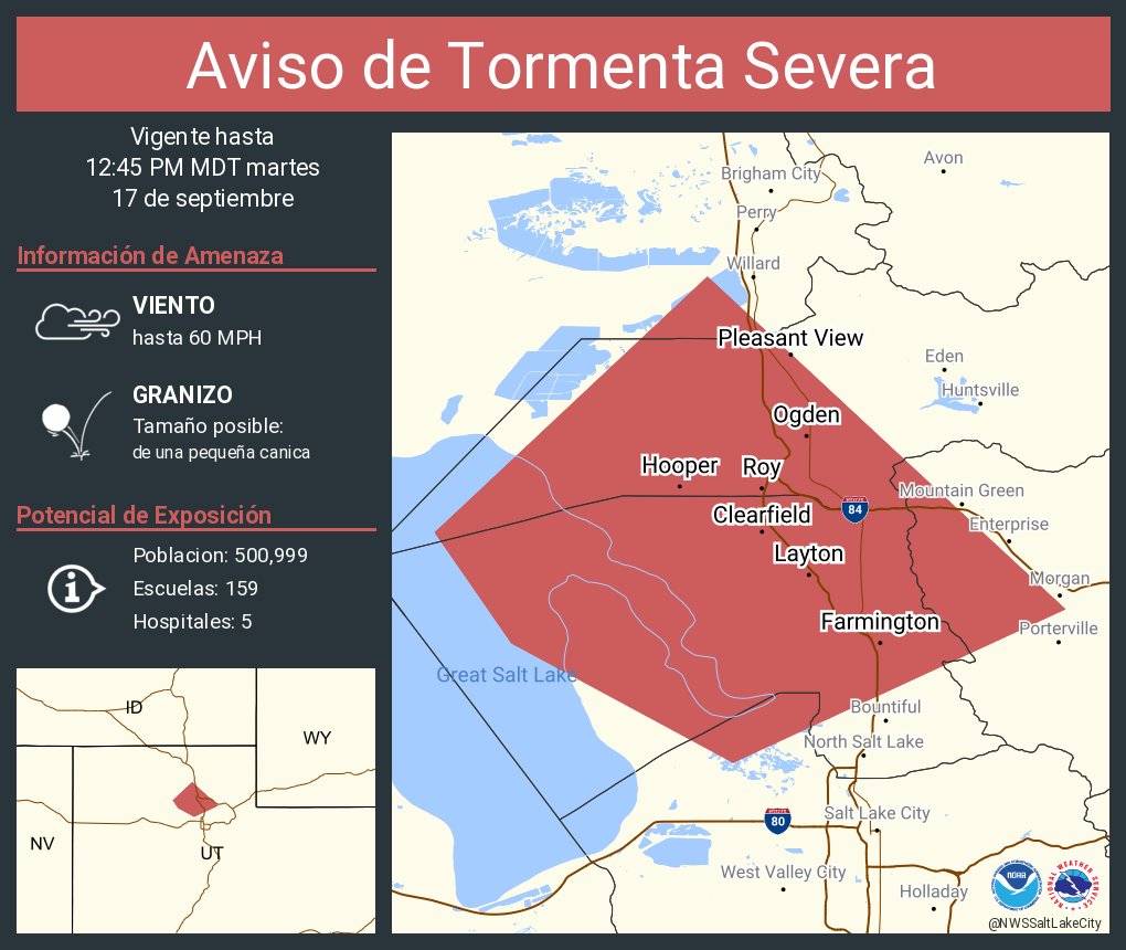
ALT Este gráfico muestra la localización en el mapa de un aviso de tormenta severa. El aviso estará en efecto hasta las 12:45 PM MDT. El aviso incluye a Ogden UT, Layton UT, Roy UT. El aviso incluye el suroeste del condado de Weber en el norte de Utah, el condado de el este centro de Box Elder en el norte de Utah, el condado de Davis en el norte de Utah, el condado de el norte centro de Salt Lake en el norte de Utah y el condado de el oeste centro de Morgan en el norte de Utah. Las amenazas asociadas a este aviso son: ráfagas de viento de 60 MPH y granizo del tamaño de una pequeña canica. Hay 500,999 personas bajo este aviso incluyendo 159 escuelas y 5 hospitales.
Northern Wasatch Front downslope winds are likely later in the week. There is high confidence in enhanced winds Wednesday night into Thursday and Thursday night into Friday. Gusts in excess of 45 mph are expected, with around a 15% chance for gusts to 60 mph. #utwx
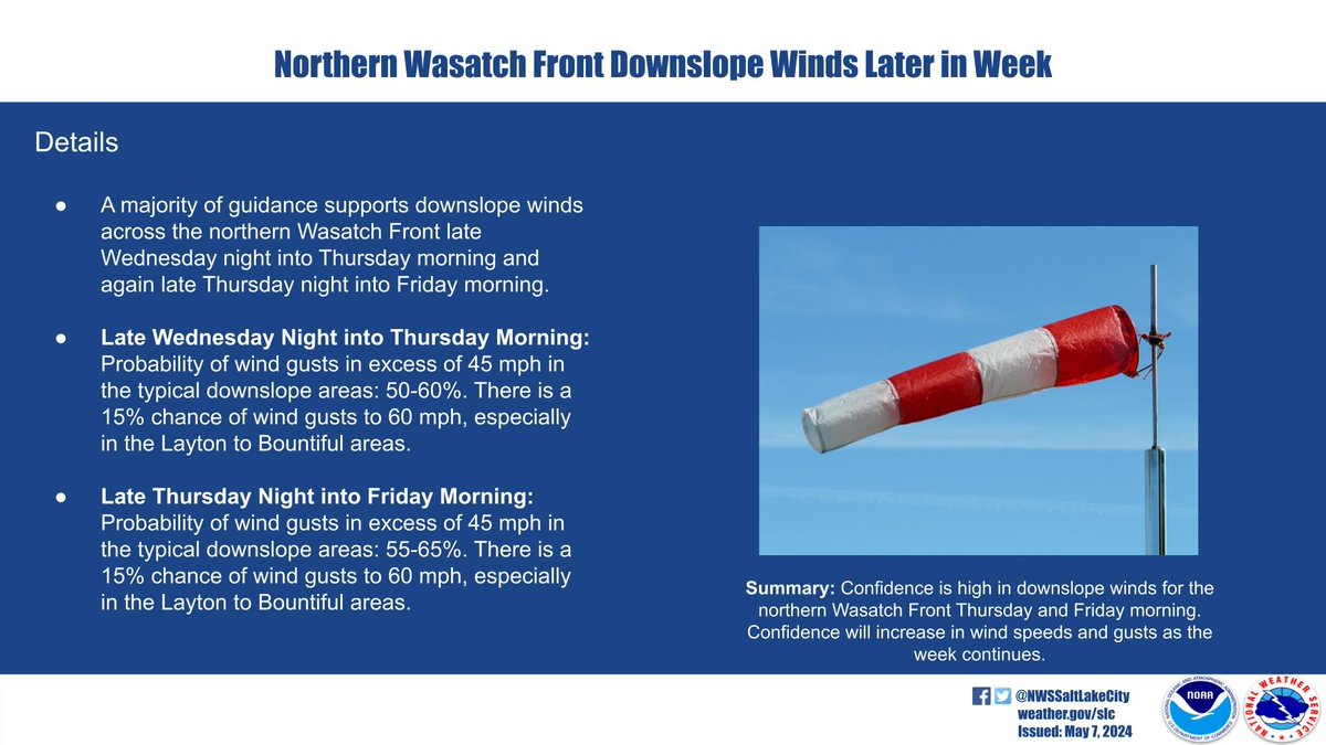
ALT Northern Wasatch Front downslope winds are likely later in the week. There is high confidence in enhanced winds Wednesday night into Thursday and Thursday night into Friday. Gusts in excess of 45 mph are expected, with around a 15% chance for gusts to 60 mph. Peak winds will likely be from Bountiful to Layton.
Peak downslope winds will be between roughly 9 p.m. Thursday and 9 a.m. Friday. This will be within an 18-24 hour timeframe of enhanced winds. Gusts will likely reach 70-85 mph, strongest for Davis and Weber counties. #utwx
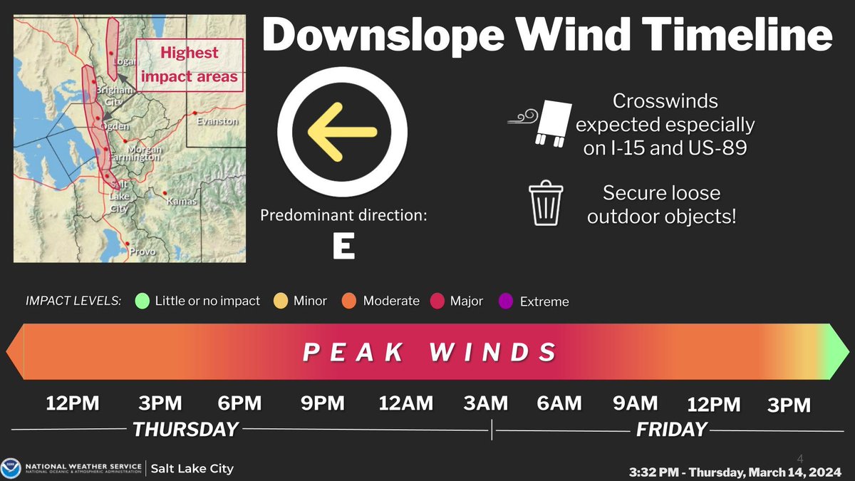
ALT This graphic details an impact timeline for the Wasatch Front and Cache Valley for easterly downslope winds. Peak winds will be from around 9 p.m. Thursday through 9 a.m. Friday.
⚠Attention! NOW is the time to prepare for dangerous downslope winds if you live in prone areas...including portions of the N. Wasatch Front, Cache Valley, and areas E of Price.
See the following thread for more information on timing, impacts, and how to prepare. ⬇(1/5) #utwx
Accumulating snow will begin Tuesday morning across the northern Utah mountains with snow arriving later in the day across the central and southern Utah mountains. Winter weather advisories are in effect through 6pm Wednesday. #utwx
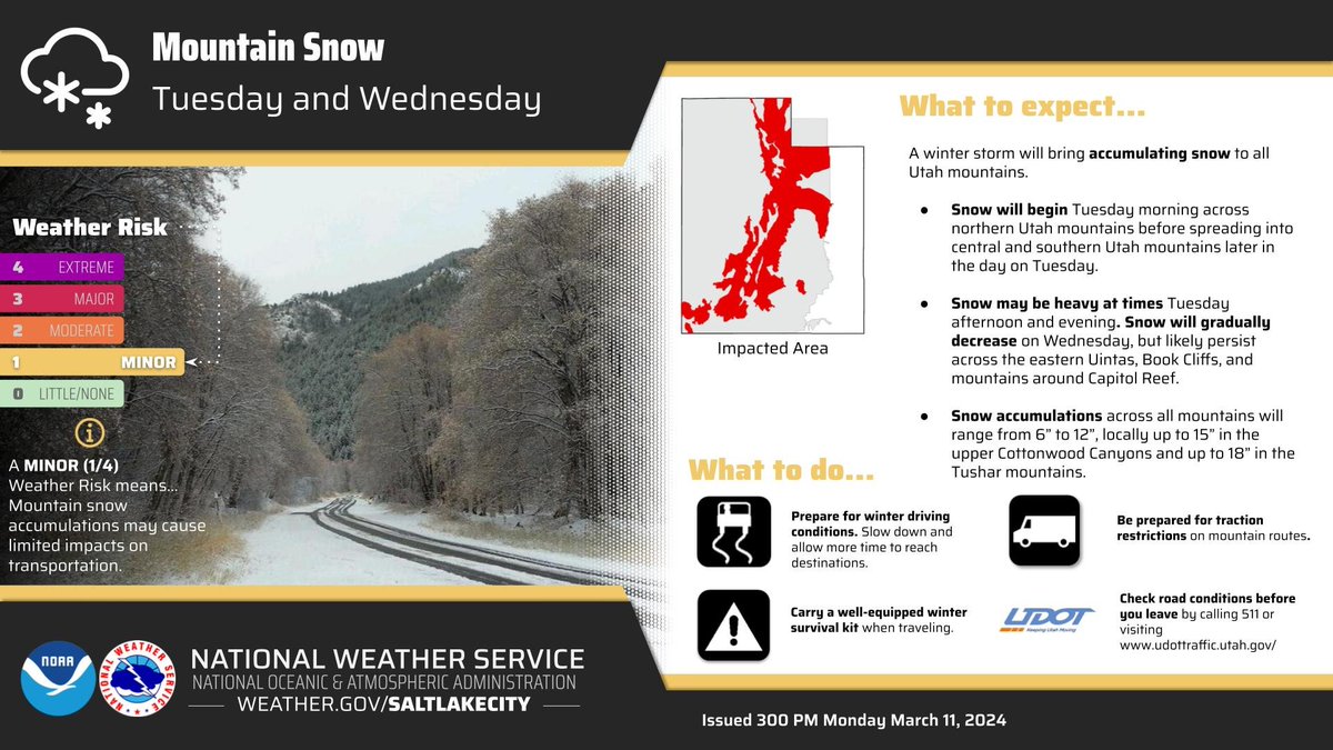
ALT A graphic showing mountain snow potential for all Utah mountains, and a list of ways you can prepare.
SAT MORNING UPDATE: Winds will continue to increase over W UT valleys today ahead of a front and spread into S UT, with some gusts in excess of 65 mph expected. These will be the strongest winds of the season. Please secure loose outdoor objects if you haven't already. #utwx
10:05 am - We are seeing blowing dust on our satellites this morning west of Utah Lake (bright pink at the start of this loop). Strong winds for the rest of the day are likely to loft additional areas of blowing dust. #UTwx
❄️↘️ Snow levels are on their way down tonight along the Wasatch Front; which will allow for rain/snow mix (or all snow!) along the benches. By tomorrow morning, snow levels are forecast at the surface though precip amounts will be little to none. #UTwx
Impressive snowfall is on track through the weekend and into next week. Winter Storm Warnings are in effect for southwest Wyoming and northern Utah. Check out our key messages for the event that will last into Monday. Forecast snowfall is shown below that. #utwx#wywx
❄️🌬️A wild weather weekend on the way ❄️- a good time to evaluate your preparations (home and car), play the "what if" game, and check in on family and neighbors. Stay warm, don't crash, and be of help. ☃️A good time to build community!😀👏
National Alert Test Tomorrow, Oct 4 @ 12:20 pm, local time. How will you test? FEMA & the FCC will send an alert over cell phones, radios & TV's. What is your emergency communication plan? Who do you need to contact? Who needs to contact you? Please practice a family contact plan
.@FEMA and @FCC will conduct a national test of the Wireless Emergency Alert and the Emergency Alert System this fall. Cell phones, wireless devices, TVs and radios across the country will be sent a test alert around 2:20 pm on Oct 4.
Info: fema.gov/press-release/20230…#IPAWS#WEA
ALT A person holds a mobile device showing a test emergency alert reading, "National Alert. This is a test of the National Wireless Emergency Alert System. No action is needed."
Meteorologist Brent Schumacher shot this video of the storm rolling into Salt Lake City. The dark clouds enveloped the city before releasing a downpour of rain! 🌧
#Prepare for a gas leak: After a disaster, look, smell, and listen for leaky gas connections. If you believe there’s a gas leak, IMMEDIATELY leave your home and contact the gas utility. Keep the doors open when you leave. Learn more from @DominionEnergy: ow.ly/s5OX30rNZjG
It's no secret that it's HOT outside. That can be dangerous for people, young and old. Take a minute to check on your elderly family members and neighbors. Make sure they are keeping their homes cool. We appreciate @NWSSaltLakeCity for important weather watches and warnings.
🚧US 89 lane restrictions🚧 Thru Sat 6/24, day time, north bound lanes will be restricted between Antelope and SR 193, for the final paving. Night time closures will continue through the end of June. Similar restrictions in Fruit Heights😉