
Meteorólogo con pasión, la meteorología marina siempre, padre de familia, amante de la pesca...
Joined September 2011
- Tweets 19,219
- Following 539
- Followers 5,015
- Likes 35,076
3,344 Photos and videos


Weatherman retweeted

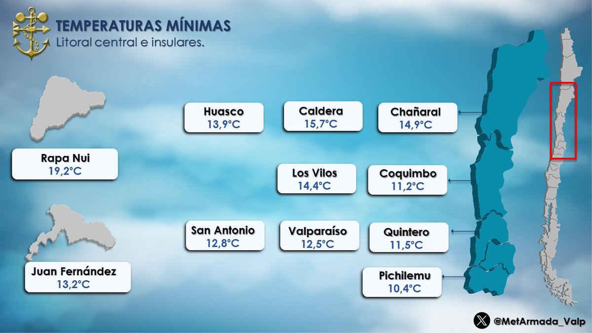
Temperaturas Mínimas 🥶 registradas esta mañana de #Jueves 18 de #Junio en las estaciones meteorológicas del litoral central e insular.
#Chañaral #Coquimbo #LosVilos #Quintero #Valparaiso #SanAntonio #Rapanui #Huasco #Juan_Fernandez #Pichilemu 📷
1
2
137
Para tener presente @chvtiempo @ucvradio @sitiodelsuceso @CEValparaiso @alertaconcon @AlertaNoticiasV @AlertaVR @girovisualtv @g5_noticias @AgenciaQuinta @Quintavision @valparaisoinfo @chvnoticias @biobio @Emol @lun @latercera @InfinitaFM @AllisonGohler @EduardoTVT @cristobalreus
19 Oct 2021

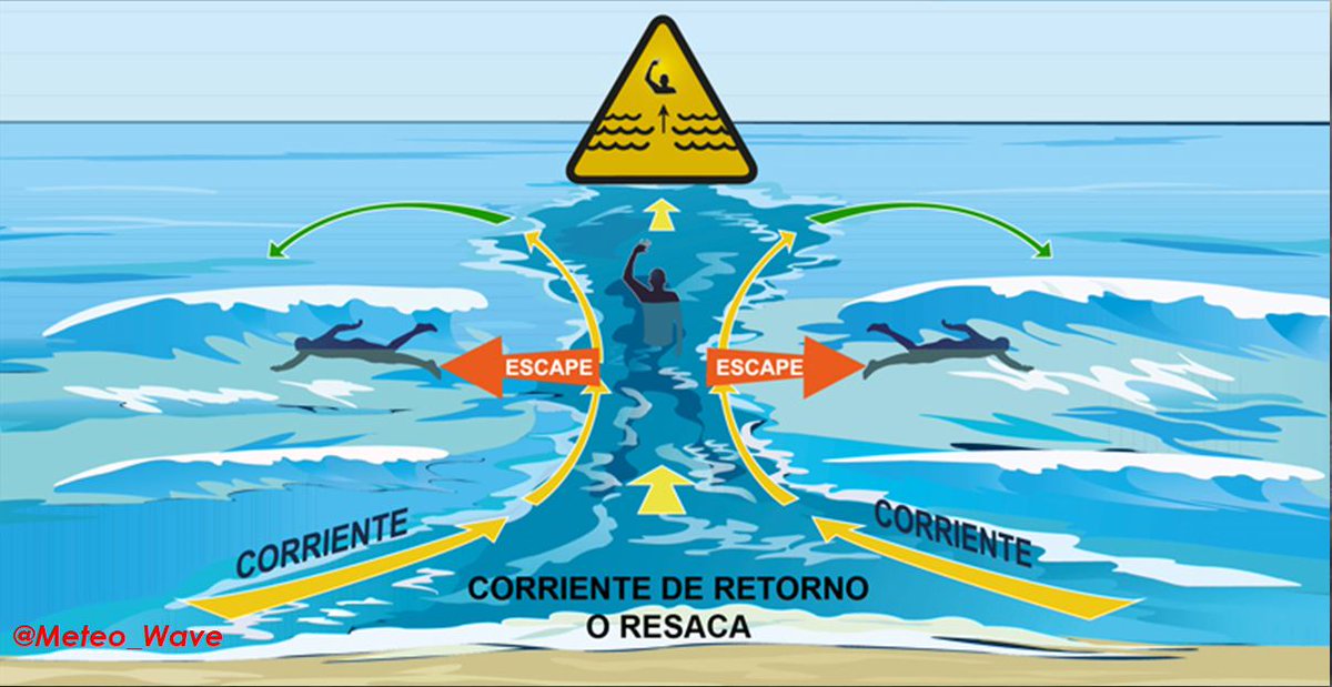
La Resaca o Corriente de Retorno es muy fuerte y te alejará de la orilla. Si te atrapa:
🚩No nade contra la corriente
🚩Nada hacia fuera de la corriente, paralelo a la costa y luego hacia la orilla
🚩Si no logra escapar, manténgase a flote
🚩Pida auxilio, grite o agite los brazos
17
Para tener presente @chvtiempo @ucvradio @sitiodelsuceso @CEValparaiso @alertaconcon @AlertaNoticiasV @AlertaVR @girovisualtv @g5_noticias @AgenciaQuinta @Quintavision @valparaisoinfo @chvnoticias @biobio @Emol @lun @latercera @InfinitaFM @AllisonGohler @EduardoTVT @cristobalreus
Jun 17

La carte des anomalies à 500 hPa pour les 7 prochains jours illustre un verrouillage quasi total de la circulation atmosphérique. Dans ces conditions, la chaleur saharienne dispose d’un véritable boulevard pour s’installer durablement sur une grande partie de l’Europe.

2
73
Para tener presente @chvtiempo @ucvradio @sitiodelsuceso @CEValparaiso @alertaconcon @AlertaNoticiasV @AlertaVR @girovisualtv @g5_noticias @AgenciaQuinta @Quintavision @valparaisoinfo @chvnoticias @biobio @Emol @lun @latercera @InfinitaFM @AllisonGohler @EduardoTVT @cristobalreus
17h

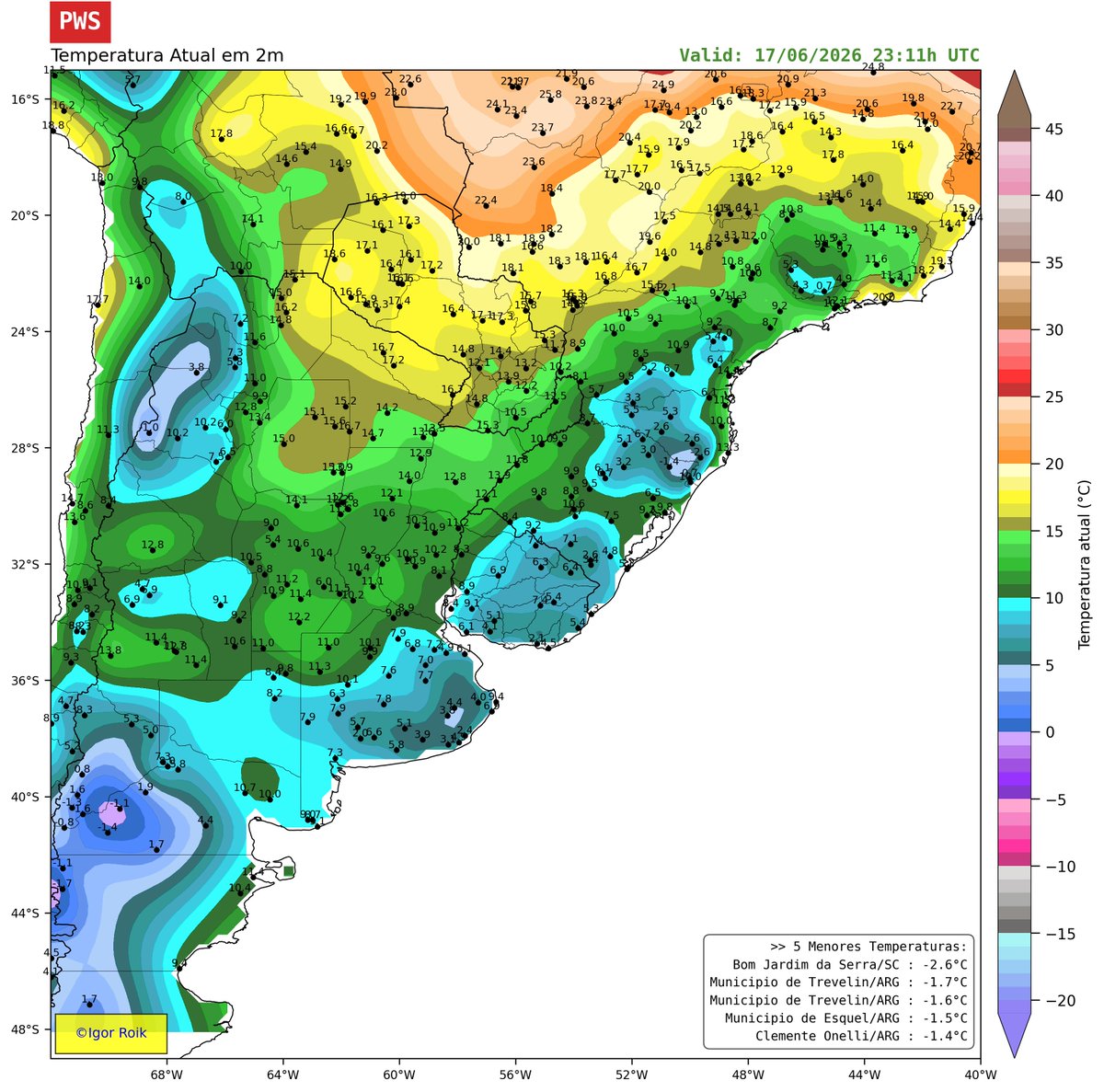
Já temos negativa neste momento no Sul do Brasil.
Faz -2.6°C em Bom Jardim da Serra/SC.
97
Para tener presente @chvtiempo @ucvradio @sitiodelsuceso @CEValparaiso @alertaconcon @AlertaNoticiasV @AlertaVR @girovisualtv @g5_noticias @AgenciaQuinta @Quintavision @valparaisoinfo @chvnoticias @biobio @Emol @lun @latercera @InfinitaFM @AllisonGohler @EduardoTVT @cristobalreus
Jun 17

New: Tropical Storm #Arthur forms - the first of the Atlantic Season. It will dump heavy rain causing #Flooding along the #Gulf Coast and west FL Panhandle. But the rain will miss most of the #Florida Peninsula.
Tropical storms during El Niños are not uncommon in June. We average about 2 per May/June during an El Niño.

1
84
Weatherman retweeted
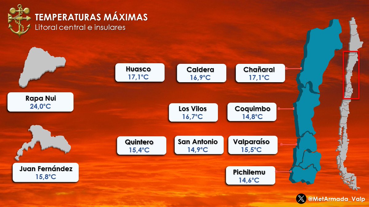
Temperaturas Máximas 🌡️ 📷#Miércoles 17 de #Junio en las estaciones meteorológicas del litoral central e insular.📷 #Coquimbo #LosVilos #Valparaíso #SanAntonio #RapaNui #Juan_Fernandez #Chañaral #Caldera #Huasco #Quintero #Pichilemu
1
3
333
Weatherman retweeted
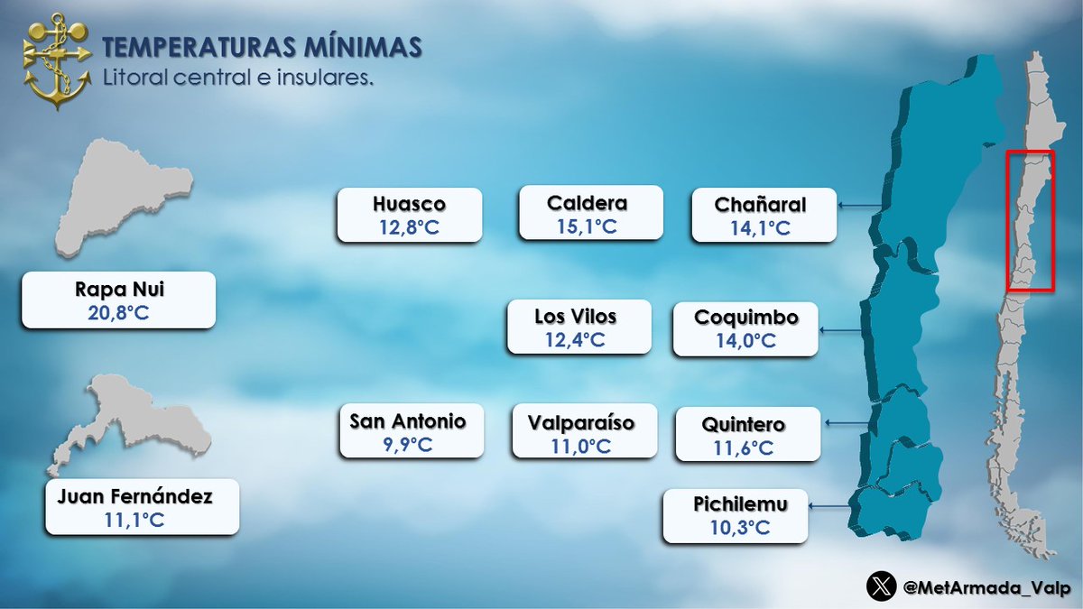
Temperaturas Mínimas 🥶 registradas esta mañana de #Miercoles 17 de #Junio en las estaciones meteorológicas del litoral central e insular. #Chañaral #Coquimbo #LosVilos #Quintero #Valparaiso #SanAntonio #Rapanui #Huasco #Juan_Fernandez #Pichilemu 📷
3
3
250

Jun 17
Para tener presente @chvtiempo @ucvradio @sitiodelsuceso @CEValparaiso @alertaconcon @AlertaNoticiasV @AlertaVR @girovisualtv @g5_noticias @AgenciaQuinta @Quintavision @valparaisoinfo @chvnoticias @biobio @Emol @lun @latercera @InfinitaFM @AllisonGohler @EduardoTVT @cristobalreus

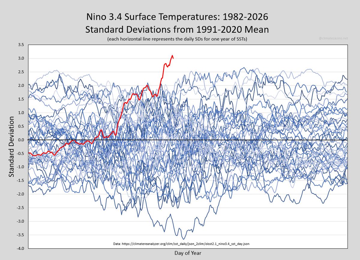
Breaking News!
y-axis alert!
Nino 3.4 sea surface temperatures are now more than 3 standard deviations above the 1991-2020 mean, forcing an extension of the y-axis up to 3.5σ.
And that line way at the bottom? That's 1988.
2
147
Jun 17
Para tener presente @chvtiempo @ucvradio @sitiodelsuceso @CEValparaiso @alertaconcon @AlertaNoticiasV @AlertaVR @girovisualtv @g5_noticias @AgenciaQuinta @Quintavision @valparaisoinfo @chvnoticias @biobio @Emol @lun @latercera @InfinitaFM @AllisonGohler @EduardoTVT @cristobalreus
Jun 17
The “Cold Blob” and talk of the collapse of a vital ocean current has been all over the news lately. New research confirms the peculiar cold blob is a canary in a coalmine for our climate. A collapse would cause climate chaos. But how likely is it? Here’s a very simple video about how the AMOC works, the latest science, the tipping point, and what collapse would mean to Earth’s climate. #AMOC #climatechange #science #STEM
1
64
Jun 17
Para tener presente @chvtiempo @ucvradio @sitiodelsuceso @CEValparaiso @alertaconcon @AlertaNoticiasV @AlertaVR @girovisualtv @g5_noticias @AgenciaQuinta @Quintavision @valparaisoinfo @chvnoticias @biobio @Emol @lun @latercera @InfinitaFM @AllisonGohler @EduardoTVT @cristobalreus
Jun 17

El Niño was sparked by a Kelvin wave that shifted huge amounts of warm water from west to east across the undersea Pacific since April.
And now, a new Kelvin wave is forming.
Yet more warm water will move toward the eastern Pacific and El Niño forecasts may trend even stronger.
2
173
Jun 17
Para tener presente @chvtiempo @ucvradio @sitiodelsuceso @CEValparaiso @alertaconcon @AlertaNoticiasV @AlertaVR @girovisualtv @g5_noticias @AgenciaQuinta @Quintavision @valparaisoinfo @chvnoticias @biobio @Emol @lun @latercera @InfinitaFM @AllisonGohler @EduardoTVT @cristobalreus
Jun 17

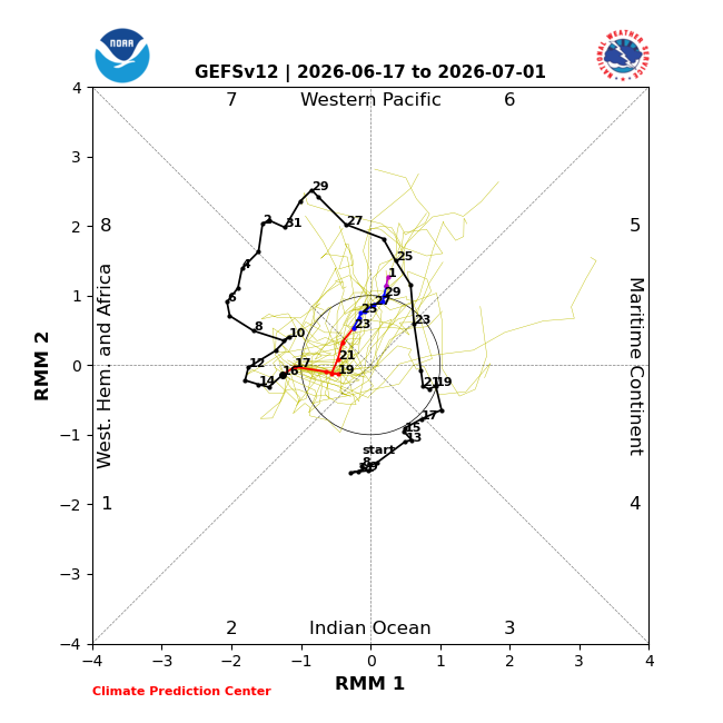
MJO forecast to return to phase 6 in late June or early July should enhance W anomalies across the equatorial #Pacific & help strengthen #ElNino in the coming weeks. SOI is strongly negative indicating a good coupling between the atmosphere & sea-surface temperature anomalies.
1
101
Jun 16
Para tener presente @chvtiempo @ucvradio @sitiodelsuceso @CEValparaiso @alertaconcon @AlertaNoticiasV @AlertaVR @girovisualtv @g5_noticias @AgenciaQuinta @Quintavision @valparaisoinfo @chvnoticias @biobio @Emol @lun @latercera @InfinitaFM @AllisonGohler @EduardoTVT @cristobalreus
Jun 16

Loggerhead sea turtles 🐢 don’t just migrate willy-nilly. As it turns out, they follow a narrow band of ideal chlorophyll and heat levels—which stretches across the Pacific and moves north and south with the seasons!
In honor of #WorldSeaTurtleDay, see how data collected from tagged turtles and @NOAA’s #satellites reveals this migration pattern!
1
83
Jun 16
Para tener presente @chvtiempo @ucvradio @sitiodelsuceso @CEValparaiso @alertaconcon @AlertaNoticiasV @AlertaVR @girovisualtv @g5_noticias @AgenciaQuinta @Quintavision @valparaisoinfo @chvnoticias @biobio @Emol @lun @latercera @InfinitaFM @AllisonGohler @EduardoTVT @cristobalreus

Jun 16

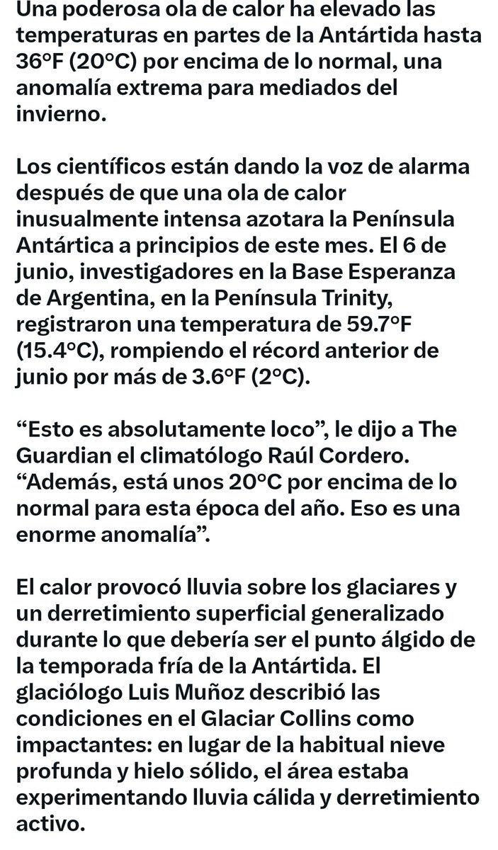
A powerful heatwave has pushed temperatures in parts of Antarctica up to 36°F (20°C) above normal, an extreme anomaly for the middle of winter.
Scientists are raising alarms after an unusually intense heatwave struck the Antarctic Peninsula earlier this month. On June 6, researchers at Argentina’s Esperanza Base on the Trinity Peninsula recorded a temperature of 59.7°F (15.4°C), breaking the previous June record by more than 3.6°F (2°C).
“This is absolutely crazy,” climate scientist Raúl Cordero told The Guardian. “It is also about 20°C above normal for this time of the year. That is a huge anomaly.”
The warmth triggered rain on glaciers and widespread surface melting during what should be the depths of Antarctica’s cold season. Glaciologist Luis Muñoz described conditions on the Collins Glacier as shocking: instead of the usual deep snow and solid ice, the area was experiencing warm rain and active melting.
While a single heatwave will not cause Antarctica’s massive ice sheets to collapse, researchers note that such extreme warm events are becoming more frequent. They are linked to stronger westerly winds influenced by climate change.
Antarctica’s ice is critical for global sea-level stability, and scientists continue to monitor vulnerable areas such as the Thwaites Glacier. This latest event serves as a stark reminder that even Earth’s coldest continent is increasingly feeling the effects of a warming world.

2
158
Jun 16
Para tener presente @chvtiempo @ucvradio @sitiodelsuceso @CEValparaiso @alertaconcon @AlertaNoticiasV @AlertaVR @girovisualtv @g5_noticias @AgenciaQuinta @Quintavision @valparaisoinfo @chvnoticias @biobio @Emol @lun @latercera @InfinitaFM @AllisonGohler @EduardoTVT @cristobalreus
Jun 16
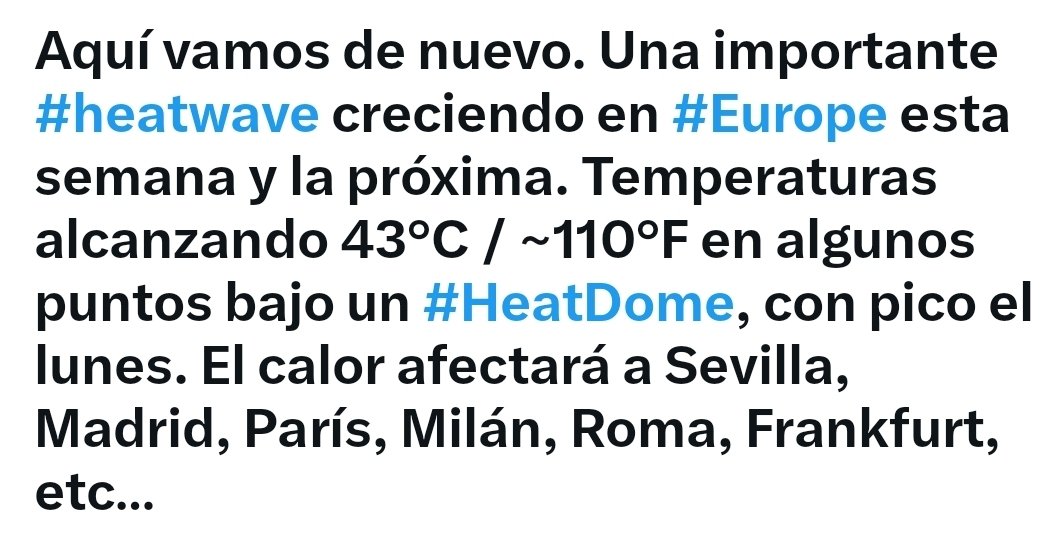
Here we go again. Major #heatwave growing across #Europe this week into next week. Temps reaching 43C / ~110F in spots under a #HeatDome, peaking on Monday. The heat will impact Sevilla, Madrid, Paris, Milan, Rome, Frankfurt, etc…
2
102
Jun 16
Para tener presente @chvtiempo @ucvradio @sitiodelsuceso @CEValparaiso @alertaconcon @AlertaNoticiasV @AlertaVR @girovisualtv @g5_noticias @AgenciaQuinta @Quintavision @valparaisoinfo @chvnoticias @biobio @Emol @lun @latercera @InfinitaFM @AllisonGohler @EduardoTVT @cristobalreus

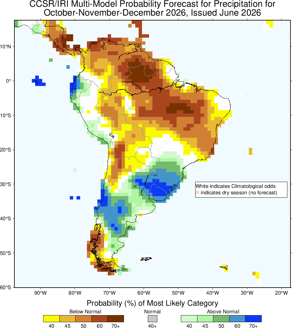
#pronóstico climático del IRI (@climatesociety) de anomalías de lluvia sobre Sudamérica para OND 2026. Para cuenca Río de la Plata época de mayor impacto #ENSO. Observar anomalías ( ) esperadas en litoral #Ecuador, centro #Chile y región Sur #Brasil, litoral #Argentina y #Uruguay
2
106
Weatherman retweeted
Temperaturas Mínimas 🥶 registradas esta mañana de #Martes 16 de #Junio en las estaciones meteorológicas del litoral central e insular.
#Chañaral #Coquimbo #LosVilos #Quintero #Valparaiso #SanAntonio #Rapanui #Huasco #Juan_Fernandez #Pichilemu 📷

1
4
283
Jun 16
Para tener presente @chvtiempo @ucvradio @sitiodelsuceso @CEValparaiso @alertaconcon @AlertaNoticiasV @AlertaVR @girovisualtv @g5_noticias @AgenciaQuinta @Quintavision @valparaisoinfo @chvnoticias @biobio @Emol @lun @latercera @InfinitaFM @AllisonGohler @EduardoTVT @cristobalreus
Jun 16
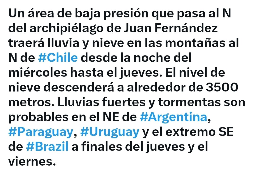
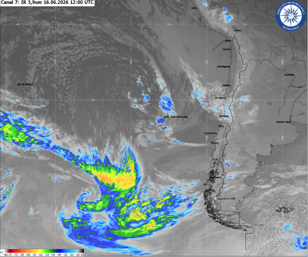
Low pressure passing N of Juan Fernandez archipelago will bring rain & mountain snow to N #Chile Wednesday night into Thursday. Snow level will fall to around 3500 meters. Heavy rain & thunder is likely in NE #Argentina, #Paraguay, #Uruguay & far SE #Brazil late Thurs & Fri.
1
87
Jun 16
Para tener presente @chvtiempo @ucvradio @sitiodelsuceso @CEValparaiso @alertaconcon @AlertaNoticiasV @AlertaVR @girovisualtv @g5_noticias @AgenciaQuinta @Quintavision @valparaisoinfo @chvnoticias @biobio @Emol @lun @latercera @InfinitaFM @AllisonGohler @EduardoTVT @cristobalreus

Jun 16
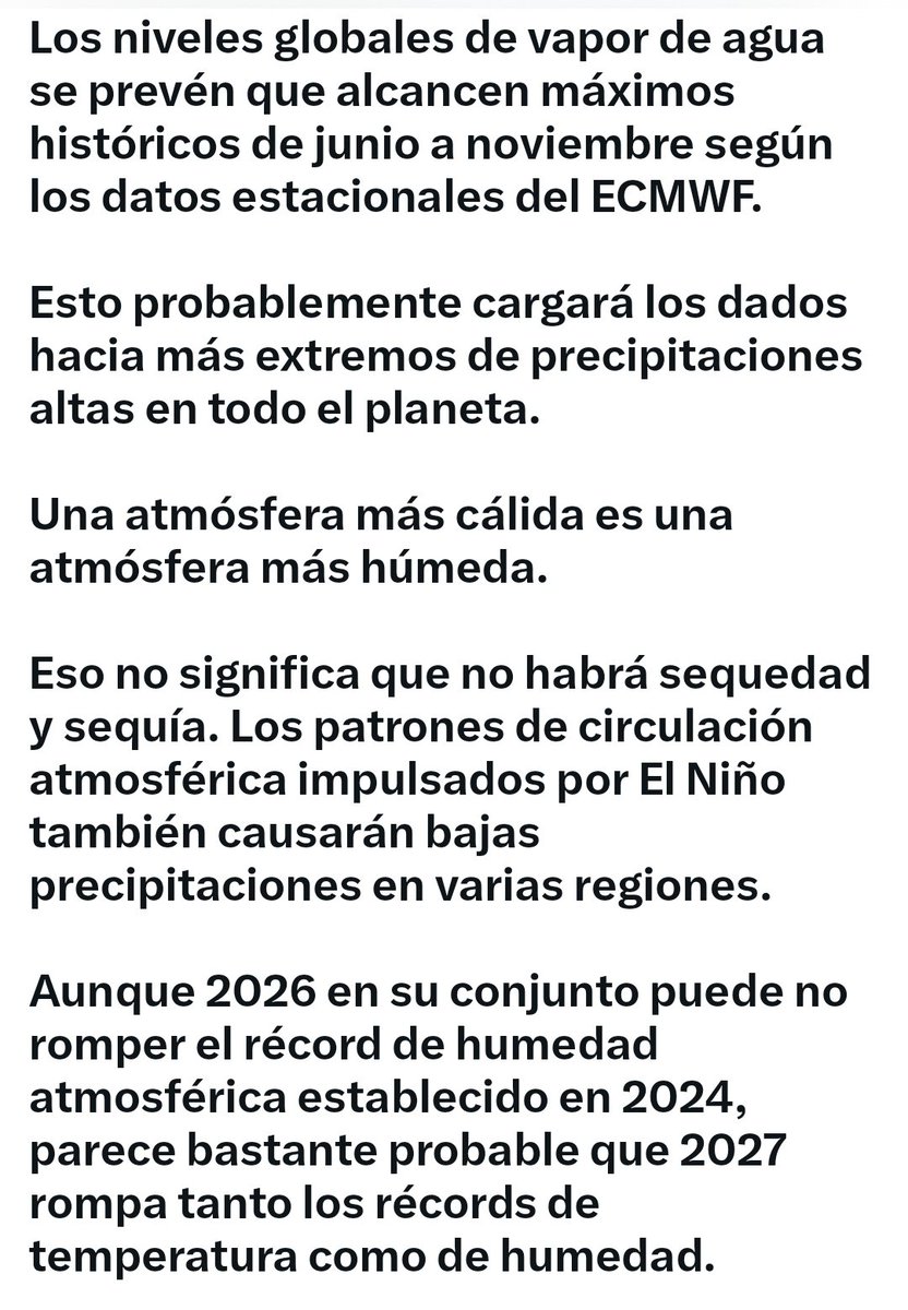
Global water vapor levels are predicted to reach record highs from June to November according to ECMWF seasonal data.
This will probably load the dice toward more high precipitation extremes across the planet.
A warmer atmosphere is a moister atmosphere.
That doesn't mean that there won't be dryness and drought. Atmospheric circulation patterns driven by El Niño will cause low precipitation in several regions, too.
Although 2026 as a whole may not break the atmospheric moisture record set in 2024, it appears quite likely that 2027 will break both temperature and moisture records.
That's why every fraction of a degree of warming in the equatorial Pacific matters when it comes to the potential for a record-breaking El Niño. The additional warming associated with El Niño drives up atmospheric water vapor concentrations, and the relationship is not linear. For every degree Celsius of warming, the atmosphere's water-vapor-holding capacity increases by about 7 percent.
This chart combines ERA5 observations (1940–2025) with SEAS5 forecasts (2026), averaged across the six-month period from June through November. The gray box associated with the final data point represents the range of forecast outcomes over the next six months.
Every forecast scenario points to record-high atmospheric water vapor.

1
119
Jun 16
Para tener presente @chvtiempo @ucvradio @sitiodelsuceso @CEValparaiso @alertaconcon @AlertaNoticiasV @AlertaVR @girovisualtv @g5_noticias @AgenciaQuinta @Quintavision @valparaisoinfo @chvnoticias @biobio @Emol @lun @latercera @InfinitaFM @AllisonGohler @EduardoTVT @cristobalreus

La cascada más alta del planeta Tierra, no está sobre la superficie, sino que se esconde en lo más profundo del Océano.
Su base cubre más distancia que muchos países. La caída no ocurre en un punto — se extiende a lo largo de 500 a 600 kilómetros de lecho marino, con una anchura de 480 kilómetros. Es la cascada más ancha, más alta y más caudalosa al mismo tiempo.
📹 kingxitytv (IG)
#Viral #viralvídeo
1
108
Jun 15
Para tener presente @chvtiempo @ucvradio @sitiodelsuceso @CEValparaiso @alertaconcon @AlertaNoticiasV @AlertaVR @girovisualtv @g5_noticias @AgenciaQuinta @Quintavision @valparaisoinfo @chvnoticias @biobio @Emol @lun @latercera @InfinitaFM @AllisonGohler @EduardoTVT @cristobalreus

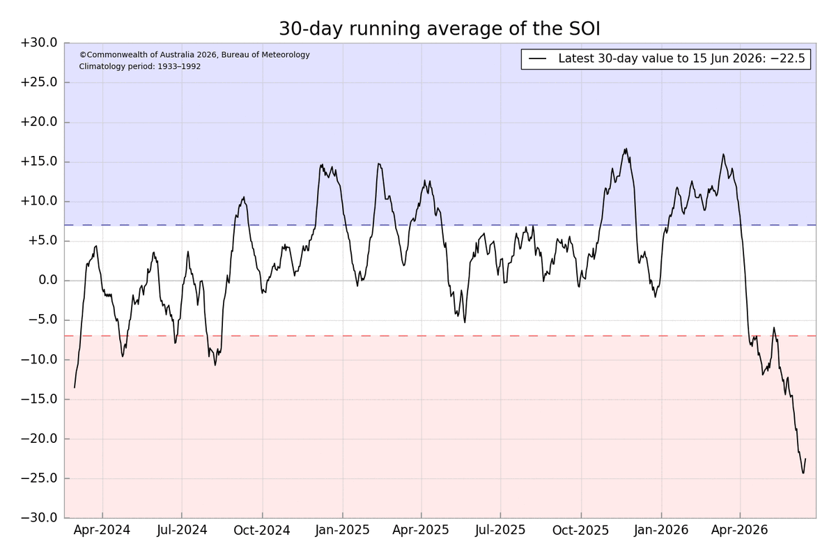
El Índice de Oscilación Sur (#IOS) se mantiene con valores negativos dentro del umbral de El Niño, indicando un mayor acoplamiento de la atmósfera con las anomalías cálidas del mar.

5
210