
Joined November 2025
- Tweets 36
- Following 137
- Followers 7
- Likes 24
14 Photos and videos


SharedWatersGIS retweeted

18 Dec 2025
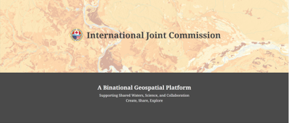
Updated launched and already making waves! Dive deeper into the International Joint Commission's updated Binational Geospatial Platform on ArcGIS Online — An essential hub for transboundary water data between Canada and the U.S. Packed with watershed dashboards, real-time hydrology layers, governance tools, and authoritative datasets from USGS, ECCC, and more. Perfect for GIS pros, researchers, water managers, and anyone advancing shared waters stewardship.Explore authoritative content and collaborate on the future of our boundary ecosystems.Start here: Search "International Joint Commission" (owner) on ArcGIS Online
Direct hub: ijc.maps.arcgis.com/home/ind… transboundary mapping journey starts now! 📷📷@IJCsharedwaters
@Esri
@EsriLivingAtlas
@esricanada
@USGS
@environmentca
@CanHydro
#GIS #ArcGISOnline #SharedWaters #IJC #TransboundaryWaters #GeospatialData #Hydrology #WaterManagement #Binational
1
2
85
SharedWatersGIS retweeted

Jan 25
Get your questions answered by our expert, Adam Olsen SȾHENEP, Member and Lead Negotiator, W̱JOȽEȽP’ (Tsartlip) First Nation, W̱SÁNEĆ British Columbia.
1
3
5
532
SharedWatersGIS retweeted

Jan 24
On this International Education Day, check out free Landsat education and remote sensing resources from USGS, including hands-on lesson plans, interactive webpages, podcasts, and tutorials.
Learn more: usgs.gov/landsat-missions/sc…
#STEM #RemoteSensing #InternationalEducationDay
11
40
1,166
Jan 26
Promoting multi-scale spatial information between Canada and the U.S. x.com/i/spaces/1OdKrOzqYNOGX
29
SharedWatersGIS retweeted
24 Nov 2025
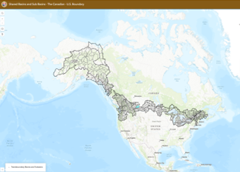
#SharedWatersGIS - is an initiative dedicated to mapping and delivering GIS-ready geospatial products and data for the transboundary water geography shared between Canada and the United States, as exemplified by the International Joint Commission's updated ArcGIS Online platform featuring harmonized watershed datasets and more. - ijc.org/en Discover the International Joint Commissions' AGOL Platform ijc.maps.arcgis.com/
1
47
Jan 23
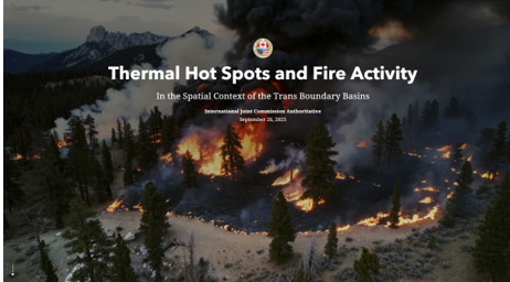
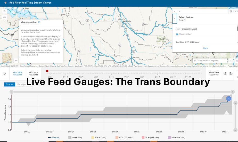
New on IJC.maps: a simple yet powerful Esri app that maps NASA/NOAA VIIRS daily thermal hotspot detections (375 m) for near real-time wildfire awareness—especially useful in shared U.S.–Canada basins where impacts cross borders.
Link: storymaps.arcgis.com/stories…
#Wildfire #VIIRS #RemoteSensing #GIS #SharedWaters #SharedWatersIJC
ALT This application displays daily NASA/NOAA VIIRS (375 m) thermal hotspot detections—often associated with active wildfires—overlaid with hydrologic boundaries to provide transboundary context across shared U.S.–Canada basins. The map supports situational awareness and is intended for screening-level use.
1
30
22 Dec 2025
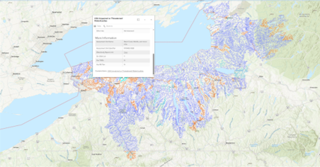
Leveraging EPA 303(d) Impaired Waters Data for Binational Basin Management
In transboundary watersheds, water quality doesn't stop at the border. EPA's Section 303(d) lists identify U.S. waters impaired by pollutants (e.g., nutrients, mercury, pathogens) needing TMDLs — valuable for spotting risks that flow north into Canada.
Key opportunity: Integrate these GIS layers with IJC's harmonized datasets in the Binational Geospatial Platform or Red River Basin Atlas to:
• Visualize cross-border impairment patterns
• Prioritize joint monitoring & restoration
• Support nutrient reduction strategies Example:
Many River segments are 303(d)-listed for nutrients — harmonizing with Canadian data could enhance binational flood quality decision-making.
Explore the Commissions Instant Application:
ijc.maps.arcgis.com/apps/ins…
Leveraging Group Layers: EPA 303D: A basic Application displaying simple Group Layers for selected Basins – Adjust the extent and create your own Web Map!
Explore EPA ATTAINS data here: epa.gov/waterdata/how-access… What's your experience overlaying U.S. impairment data in shared basins?
#SharedWatersGIS #TransboundaryWaters #WaterQuality #303d #ImpairedWaters #GIS #ArcGIS #EPA #IJC #RedRiverBasin #GreatLakes #OpenData
@IJCsharedwaters @EPA @EPAwater @Esri @EsriLivingAtlas
1
58
SharedWatersGIS retweeted
1 Dec 2025
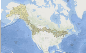
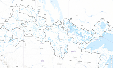
New IJC application release!
Explore harmonized U.S.–Canada transboundary basins and HUC-8 sub-basins, built from aligned WBD NHN data and enriched with CEC rivers and lakes. A seamless view of our shared waters for science, policy, and collaboration — now on the IJC AGOL. ijc.maps.arcgis.com/apps/ins…
Nouvelle application de la CMI!
Explorez les bassins et sous-bassins transfrontaliers harmonisés Canada–É.-U., issus de l’alignement WBD RHN et enrichis des rivières et lacs de la CCE. Une vue intégrée de nos eaux partagées pour la science, les politiques et la collaboration — disponible sur l’AGOL de la CMI. ijc.maps.arcgis.com/apps/ins…
#GIS #Hydrology #SharedWaters #IJC #esriuc #EsriFederalGovt
1
1
113
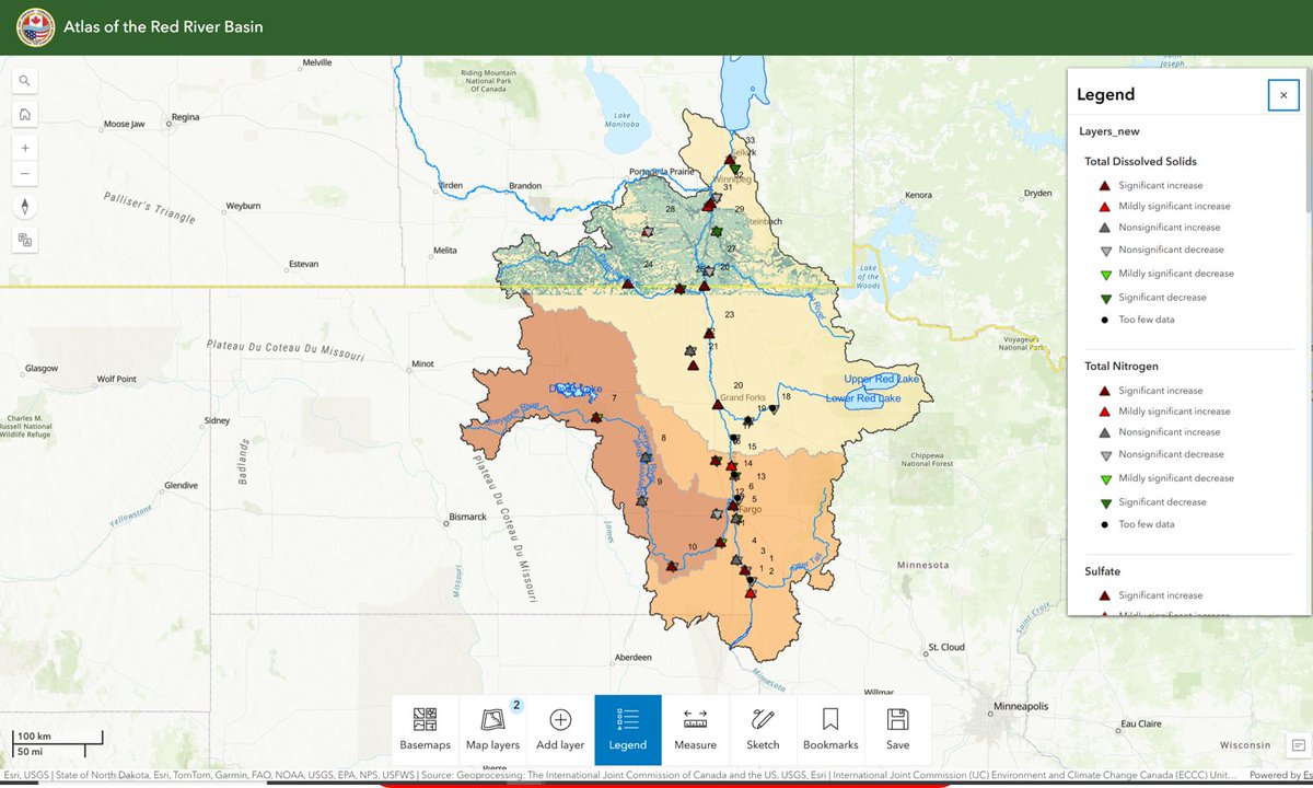
16 Dec 2025
🌎 New from @SharedWatersGIS
The International Joint Commission is excited to release our first suite of Esri Atlas–powered products. Here we are focused on the Shared Waters of the Red River Basin of the North - as an example 🇨🇦🇺🇸
ijc.maps.arcgis.com/apps/ins…
What is the Esri Atlas?
Esri Atlas is a curated collection of authoritative, ready-to-use geospatial content—basemaps, imagery, demographics, hydrology, and environmental data—designed to support rapid insight and informed decision-making.
Why this matters for the Red River Basin
By leveraging Esri Atlas content, the IJC can quickly assemble a basin-wide, transboundary view of hydrology, land cover, infrastructure, and environmental context—without duplicating data—allowing Boards and partners to focus on analysis, coordination, and action.
And this is just the beginning…
The IJC is now fully leveraging Esri Atlas products across other shared basins, including:
• St. Croix River
• Souris River
• Rainy–Lake of the Woods
Each basin benefits from the same authoritative foundation, tailored to its unique geography, governance, and management needs.
Coming soon
@SharedWatersGIS will be rolling out integrated basin products that combine Esri Atlas content with IJC-curated data, real-time services, and purpose-built applications—designed specifically for transboundary water governance.
Stay tuned. Shared waters deserve shared insight.
@MnPCA @RedRiverBasin #SharedWatersGIS #EsriAtlas #TransboundaryWaters #RedRiverBasin #IJC #GIS #SharedBasins @SharedWatersGIS @IJCommission @Esri @EsriLivingAtlas @EsriCanada
1
66
SharedWatersGIS retweeted

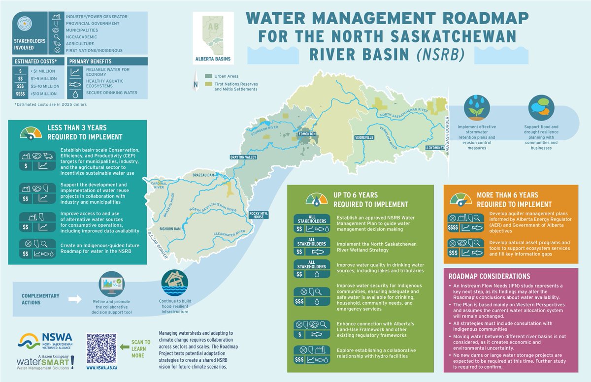
Introducing the NSRB Water Management Roadmap: Exploring how water availability may shift in the future & potential management strategies for maintaining water supplies for drinking water, healthy aquatic ecosystems & a sustainable economy.
nswa.ab.ca/initiatives/proje…
1
2
116
10 Dec 2025
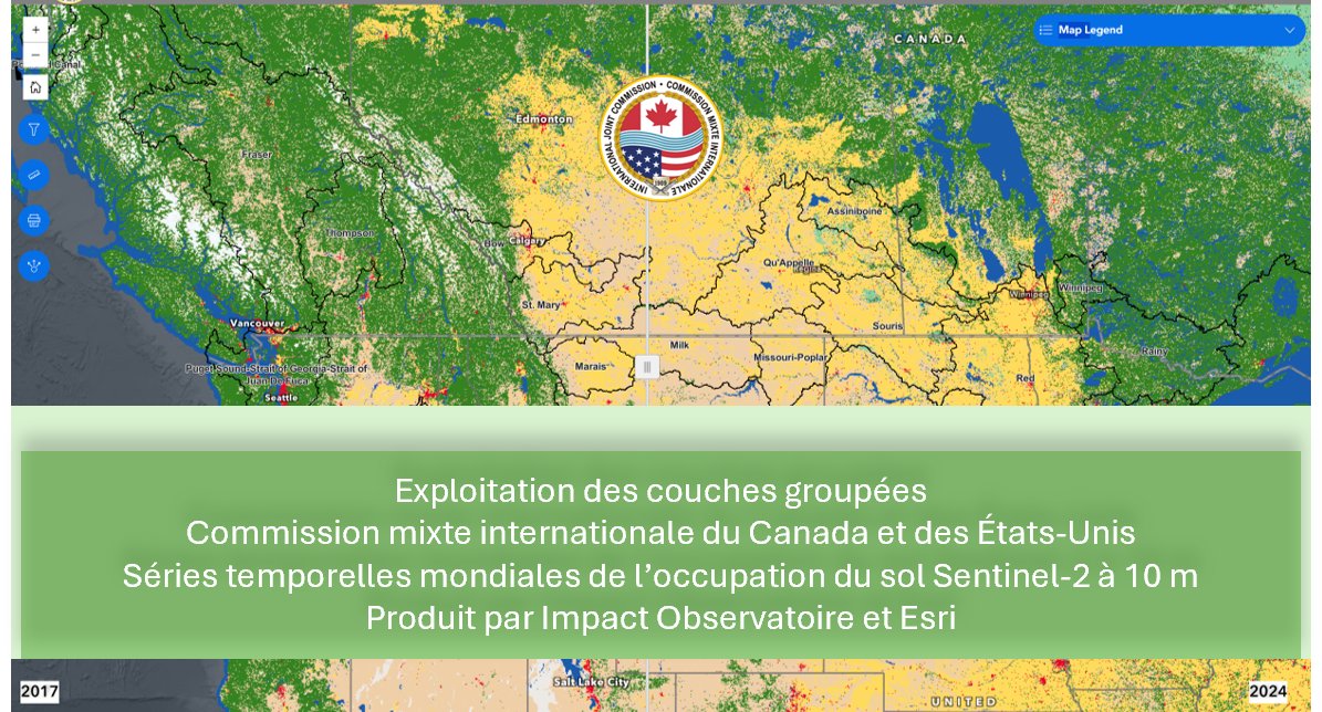
Nouveauté de @SharedWatersGIS
La Commission mixte internationale exploite pleinement les couches groupées (Group Layers) dans notre environnement AGOL afin de gérer et de diffuser des images lourdes de manière intelligente et efficace.
Qu’est-ce qu’une couche groupée?
Une couche groupée rassemble plusieurs couches connexes — imagerie, vecteurs, séries temporelles — dans un seul ensemble organisé. Cela nous permet d’activer ou de désactiver du contenu, de contrôler la symbologie et d’optimiser la performance sans dupliquer les données ni augmenter l’espace de stockage.
Grâce au nouveau Service d’imagerie Sentinel-2 sur la couverture terrestre à 10 m / séries temporelles, la CMI a maintenant créé :
• Des couches groupées homogènes pour chaque bassin transfrontalier, et
• Une application Canada–États-Unis de type swipe pour explorer les changements de couverture terrestre de part et d’autre de la frontière.
En utilisant les couches groupées, nous pouvons manipuler et organiser une imagerie complexe sans surcharger le stockage infonuagique. Et en surveillant l’utilisation à l’aide des résumés d’éléments et de couches AGOL, nous pouvons déterminer stratégiquement quels jeux de tuiles d’imagerie traiter localement pour répondre aux besoins opérationnels et de performance.
Prochaine étape : la Commission commencera à développer des statistiques zonales afin de quantifier l’évolution de la couverture terrestre dans le temps — une avancée essentielle pour la communauté de la Commission.
Des données plus intelligentes. Une empreinte plus légère. Une meilleure compréhension de nos eaux partagées. 🌊🛰️
#SIG #EauxPartagées #Esri #Sentinel2 #CMI #Géospatial #ArcGISOnline
Transfrontalier: ijc.maps.arcgis.com/apps/ins…
Comparer: experience.arcgis.com/experi…
The Living Atlas: ijc.maps.arcgis.com/apps/map…
1
55
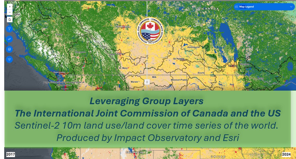
10 Dec 2025
New from @SharedWatersGIS
The International Joint Commission is taking full advantage of Group Layers in our AGOL environment to manage and deliver heavy imagery in smart, efficient ways.
What are Group Layers?
A Group Layer bundles multiple related layers—imagery, vectors, time series—into a single, organized package. This lets us toggle content, control symbology, and streamline performance without duplicating data or inflating storage.
Using the new Sentinel-2 10m Land Cover / Time-Series Imagery Service, the IJC has now built:
• Seamless Group Layers for every transboundary basin, and
• A Canada–U.S. swipe app for exploring land-cover change across the boundary.
By leveraging Group Layers, we can manipulate and curate complex imagery without over-taxing cloud storage. And by monitoring usage via ArcGIS Online Item & Layer Summaries, we can strategically decide which image tiles to process locally for performance and product needs.
As a next step, the Commission will start to develop Zonal Statistics to quantify land-cover change over time; a critical step forward for the Commission’s community.
Smarter data. Lighter footprint. Better shared-waters insight. More Examples of Group Layers to Follow
#GIS #SharedWaters #Esri #Sentinel2 #IJC #Geospatial #ArcGISOnline #TransboundaryWaters #LandCoverChange #WatershedScience #InternationalWaters #GeospatialData
Transboundary Swipe: experience.arcgis.com/experi…
The Living Atlas: ijc.maps.arcgis.com/apps/map…
Gallery of Basins: ijc.maps.arcgis.com/apps/ins…
1
56
SharedWatersGIS retweeted
21 Nov 2025
Just Launched? Here's your first stop!
We're thrilled to spotlight the International Joint Commission's powerful presence on ArcGIS Online — a goldmine for anyone working in transboundary water data between Canada and the U.S.
From watershed dashboards to real-time hydrology & governance layers, the IJC’s AGOL hub is a must-explore for GIS professionals, researchers & water managers.
Dive into authoritative geospatial content & connect with the community shaping our shared waters.
Start exploring:
Search “International Joint Commission” on ArcGIS Online Community
Your map of the boundary starts here.
#GIS #ArcGISOnline #SharedWaters #IJC #GeospatialData #TransboundaryScience
1
1
96
SharedWatersGIS retweeted

28 Oct 2025
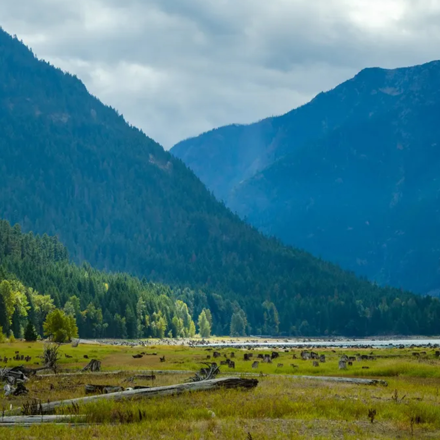
I came across photos by Eric Tsoi. You may know(of) him. Eric lives in Vancouver BC and has gathered images from so many places that I’ll admit, an hour went by as I travelled with him for a minute.
→ skagiteec.org/blog
#erictsoi
#upperskagitwatershed
#rosslake
#rossdam
1
1
1
66
SharedWatersGIS retweeted

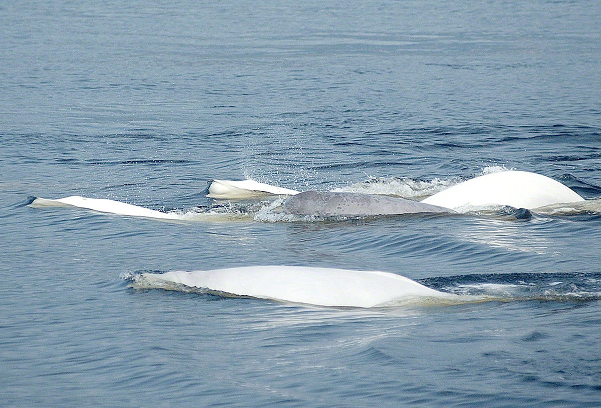
27 Nov 2025
The action plan for the St. Lawrence Estuary beluga has been posted.
Learn more: ow.ly/qXqR50XyGvN
1
2
370
SharedWatersGIS retweeted

2 Dec 2025
1
2
393
SharedWatersGIS retweeted

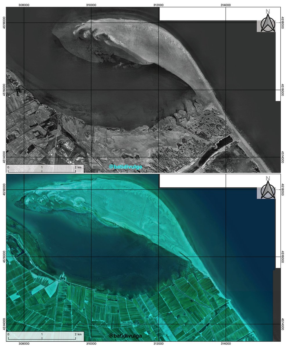
2 Dec 2025
El Fangar is the northern spit of the Ebro Delta. We're working on it there and, with an article in mind, I prepared these prelimary maps showing the awesome evolution of the zone since 1945.
@DeptDto @geologoenapuros @IGME1849 @gemar_ieo @PDE @IGeociencias @mauri_francesc
1
4
10
2,413
SharedWatersGIS retweeted
2 Dec 2025
Landsat 🛰️ captured the snowy landscape of the north central U.S. following ❄️ over the weekend. The EarthNow! Landsat Image Viewer streamed this area of central South Dakota and the Missouri River contrasting the new bright snow cover. Visit: ow.ly/vphK50XAAUj
#Landsat
7
34
1,498