I understand fully that this is the RRFS, but wow. Multiple long tracked supercells on Wednesday into Thursday being modeled. Def a very high ceiling for this event.
#ILwx#INwx#OHwx
This is not normal. The government is controlling our weather and we must do something about it. Shame on you if you think otherwise. Change starts now!!
Severe Thunderstorm Warning including Columbus OH, Springfield OH and Dublin OH until 4:15 PM EDT
ALT This graphic displays a severe thunderstorm warning plotted on a map. The warning is in effect until 4:15 PM EDT. The warning includes Columbus OH, Springfield OH and Dublin OH. This warning is for Southeastern Champaign County in west central Ohio, Western Franklin County in central Ohio, Southwestern Delaware County in central Ohio, Northeastern Clark County in west central Ohio, Southern Union County in central Ohio and Madison County in central Ohio. The threats associated with this warning are wind gusts up to 60 MPH and pea sized hail. There are 1,050,461 people in the warning along with 263 schools and 15 hospitals.
A severe thunderstorm watch has been issued for parts of Indiana, Kentucky, Ohio, Pennsylvania and West Virginia until 9 PM EDT
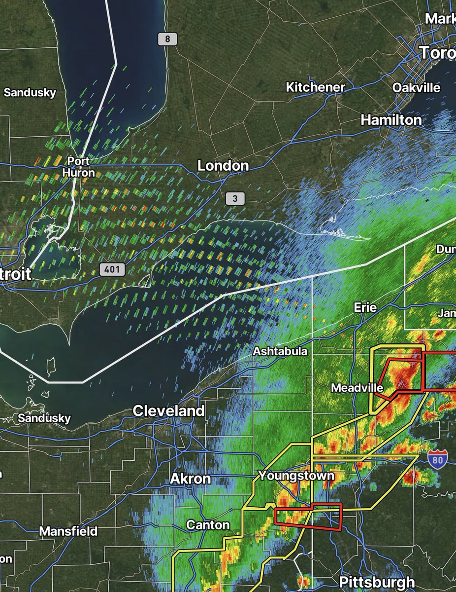
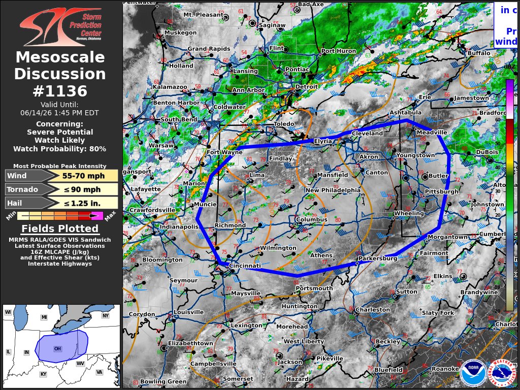
ALT This graphic displays Severe Thunderstorm watch number 333 plotted on a map. The watch is in effect until 9:00 PM EDT. The watch includes parts of Indiana, Kentucky, Ohio, Pennsylvania and West Virginia. The threats associated with this watch are a couple tornadoes possible, isolated hail up to quarter size possible and scattered gusts up to 70 mph likely. There are 16,030,707 people in the watch along with 5218 schools and 337 hospitals.
Ohio is currently the ONLY STATE in the Lower 48 with no drought at all! Ohio is one of two states with no drought when including all 50 as Alaska also remains drought free. Pretty neat!
(Tbh idk why I'm posting this, I'm just bored)
#OHwx
Tornado alley is just Illinois this year apparently. 122 tornadoes and counting so far for 2026🌪️
The states 10 year avg. (2016-25) within the same date range is only 35. The states YEARLY avg. in total is 54. Absolutely insane to think about🤯
#ILwx
Wed/Thur are checking all the boxes on the ensembles. Could be a big event for the region and we will need to keep an eye on this. I feel really bad for the state of Illinois this year as they just keep getting hit over and over again... 30% probs tonight??
#OHwx#ILwx#INwx
Wouldn't be shocked to see our severe risk moved further west for tomorrow. Very least a marginal risk. Nice line of storms for the state of Ohio tomorrow afternoon. Damaging winds would be the main threat, but I can't rule out an isolated tornado.
#OHwx
Alright if y’all wanna see me chase on Wednesday/Thursday, here’s how you can help fund it:
venmo.com/u/Stupercellcash.app/$Stupercell
One of these days, I’ll be able to stream it live to y’all👀
Never did get to say it, but major W’s to @ChasingWConnor and @hobbs2828 yesterday. Listening to Connor direct his dad to see an epic storm was absolutely insane. Glad y’all’s house is alright! Hope the powers back on :)
Elevated threat of tornadoes detected for Wednesday, June 17th, 2026.
See attached map for details.
This forecast initialized on Friday morning. Follow for future forecast updates.
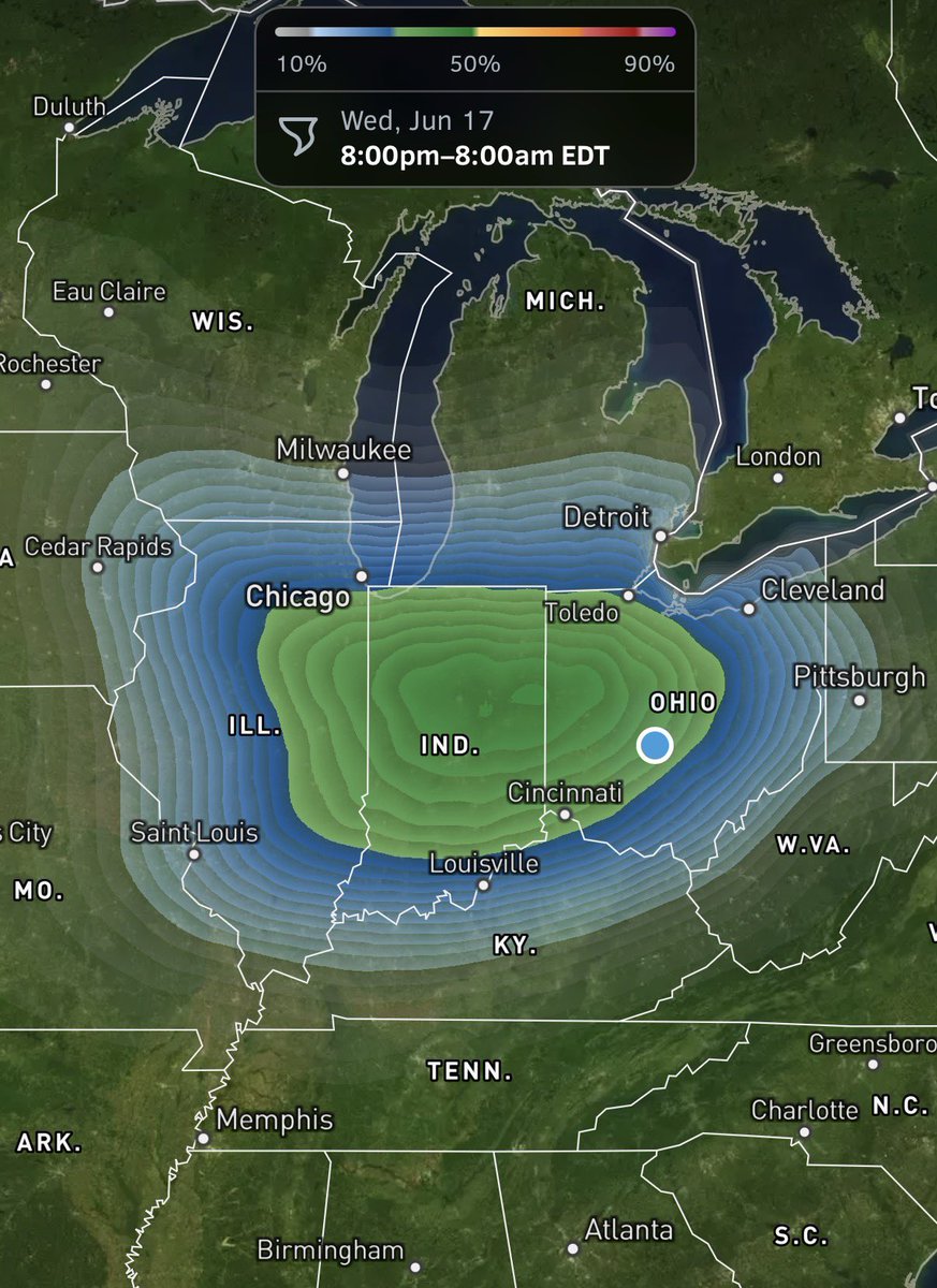
ALT StormNet-v4 tornado probability map with a 53% maximum 12-hour risk from 2026-06-17 18Z to 2026-06-18 06Z. Model initialized 2026-06-12 12Z at forecast hour 138.