
Experimental Locally-Ai developed UK severe weather model. Probabilistic thunderstorm, hail & tornado risk on 0.33° resolution grid using multi-model ensembles.
Joined April 2026
- Tweets 494
- Following 117
- Followers 90
- Likes 937
247 Photos and videos


Pinned Tweet

Jun 10
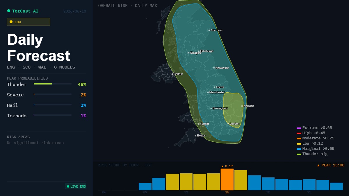
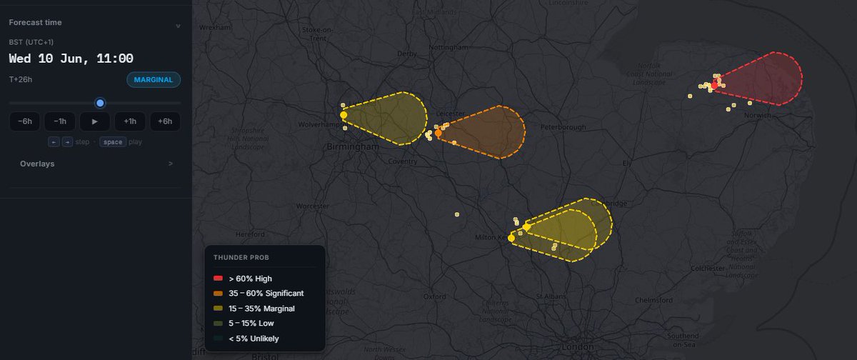
🌩️ CONVECTIVE OUTLOOK — Wed 10 June
🟡Low-end thunder risk focused on East Anglia & SE England; broader Marginal risk across central Britain & Scotland.
☔ Best CAPE (400–700 J/kg) plumes over the east, where a convergence zone (UKV) triggers storms through the afternoon. Stronger deep-layer shear in the south lets cells organise better than yesterday.
⚠️ Main threats:
⚡ Frequent lightning in stronger cells
🧊 Small hail
🌬️ Gusty, locally squally winds
🌧️ Torrential downpours, surface-water flooding risk
⚙️ Parameters: MUCAPE 400–700 J/kg (E Anglia/SE), 850–500 lapse ~28–30°C, DLS 30–50 kn (south), LLS modest, low-level convergence focus over the east.
📍 Focus: East Anglia/Lincs → SE England, scattered Midlands & central Scotland. Peak 13–18 BST.
3
468
35m
The 06z GFS Control run certainly does crank the heat throughout the entire run with Temps mostly in the mid - low 30's ! Even pumps out a 37C on Monday the 22nd June.
Just 1 run and 1 model of course this will change, but the signal is there for a period of sustained higher than Avg temps looking through the previous runs
53m

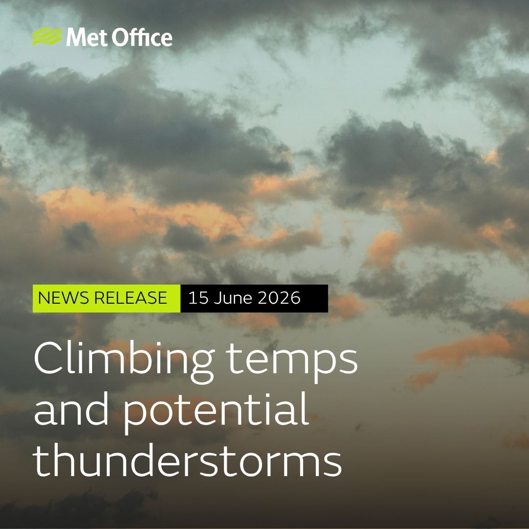
The UK is set for a week of contrasting weather, with a combination of increasingly warm and humid conditions in the south and east, and more unsettled weather affecting the north and west at times.
Details in full: metoffice.gov.uk/about-us/ne…
1
2
49
24m
Both GFS and ECMWF Ensembles are fairly split on whether the pattern turns hot or it stays fairly muted in the low-mid 20's
13
TorCast Ai retweeted

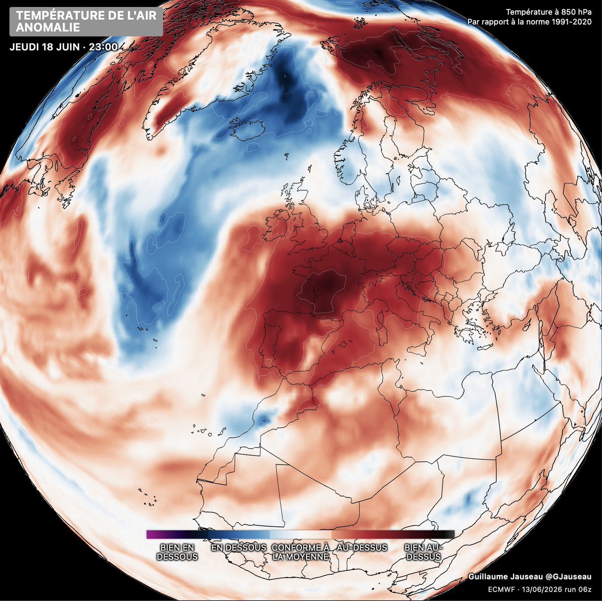
There’s a growing likelihood of a heatwave across much of Europe next week where temperatures could exceed >40°C.
In terms of the UK, it’s less clear cut on whether we’ll be tapping into the hotter air to our south.
Chart: @GJauseau
10
22
113
11,492
TorCast Ai retweeted

Jun 12
Stunning drone video shows a tornado in Ipava, Illinois, barreling straight into solar panels and sending them flying.
41
159
1,138
246,008
Jun 13
A mostly fine and warm day developing for most in the UK today with the exception of Scotland where showers will whip through on a brisk breeze, these may push into Northern England at times. Temperatures will range from 12c in the far North, to 22c in the South.
4
215
TorCast Ai retweeted

Jun 12
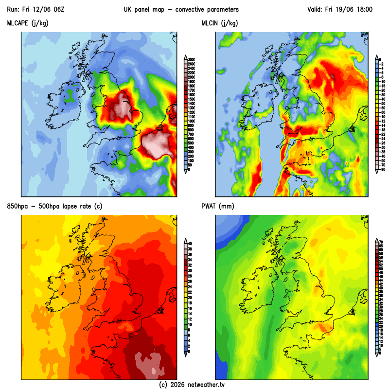
For next Friday afternoon and evening, there are early signs of a potentially active thunderstorm setup across parts of the UK.
CAPE values are currently forecast to range between 1,000–2,500 J/kg, particularly across eastern areas. These values would be supportive of strong to severe thunderstorms, although additional ingredients will be needed before any significant severe weather risk can be established.
One of the main uncertainties is the cap. Across southern areas, model guidance suggests a fairly strong cap which could suppress thunderstorm development unless it can be broken. Further north, particularly around the East Midlands, the cap appears weaker, increasing the likelihood of convective initiation. The exact positioning remains uncertain and will likely change over the coming days.
Lapse rates within the 850–500 hPa layer are forecast to be relatively steep, supporting stronger updrafts and more vigorous thunderstorm growth. Combined with moderate to high PWAT values, any storms that do develop could be capable of producing torrential rainfall.
Overall, there is growing model support for a plume-type thunderstorm setup next Friday, with the potential for thunderstorms to become fairly widespread. However, the strength and placement of the cap remains a key limiting factor.
Confidence remains low given the lead time, but the signal for a notable thunderstorm event is beginning to emerge. It's important to stress that this could still change significantly over the coming days, and the signal could easily fade away. However, based on the current UKV convective parameters, the ingredients are there to at least warrant close monitoring, with trends over the coming days likely to determine whether this develops into a more notable setup.
2
2
34
2,534
Jun 11
A rainfall radar in June that’s more akin to Winter than summer.
What a wet, horrible and soggy day
3
179
Jun 10
Today’s verification(Technically yesterday now 🤣): Better late than never due to an impromptu trip to watch Disclosure Day.
Model largely performed well again with the bulk of the activity in East England
Jun 10

🌩️ CONVECTIVE OUTLOOK — Wed 10 June
🟡Low-end thunder risk focused on East Anglia & SE England; broader Marginal risk across central Britain & Scotland.
☔ Best CAPE (400–700 J/kg) plumes over the east, where a convergence zone (UKV) triggers storms through the afternoon. Stronger deep-layer shear in the south lets cells organise better than yesterday.
⚠️ Main threats:
⚡ Frequent lightning in stronger cells
🧊 Small hail
🌬️ Gusty, locally squally winds
🌧️ Torrential downpours, surface-water flooding risk
⚙️ Parameters: MUCAPE 400–700 J/kg (E Anglia/SE), 850–500 lapse ~28–30°C, DLS 30–50 kn (south), LLS modest, low-level convergence focus over the east.
📍 Focus: East Anglia/Lincs → SE England, scattered Midlands & central Scotland. Peak 13–18 BST.
3
327
Jun 10
So from a time lapse I took earlier on today I noticed what looks like rotation. Not sure if this was enhanced by the upward motion of the wind being forced by the Dunstable Downs
1
1
13
738
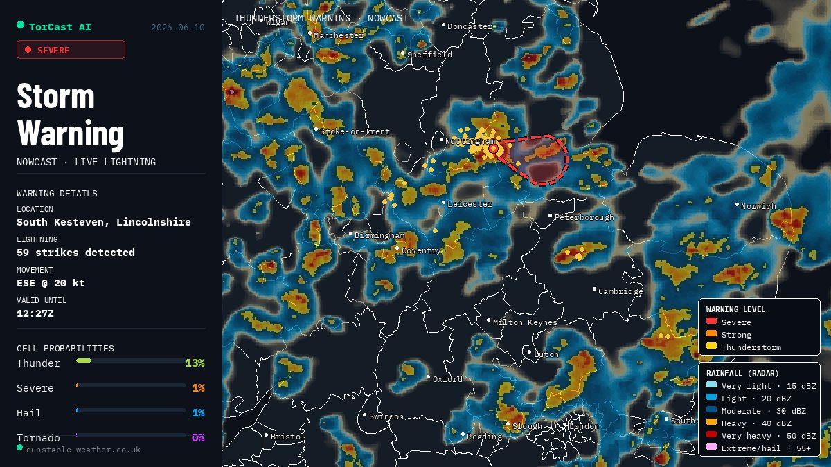
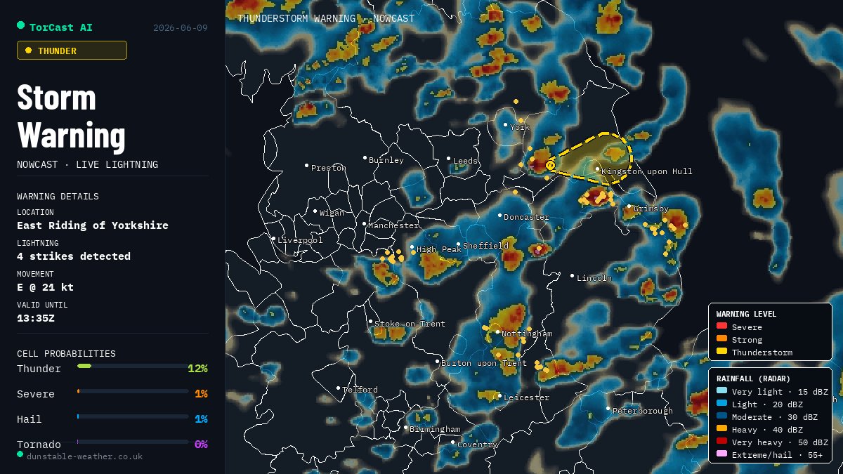
Jun 10
Quite an active storm is moving through Grantham currently. Plenty of lightning with this one
2
55
Jun 10
Hail, Heavy rain and thunder from this cell moving across my house in Dunstable atm.
1
2
127
Jun 10
Activity has already started! Several showers are already turning thundery across the East.
1
5
440
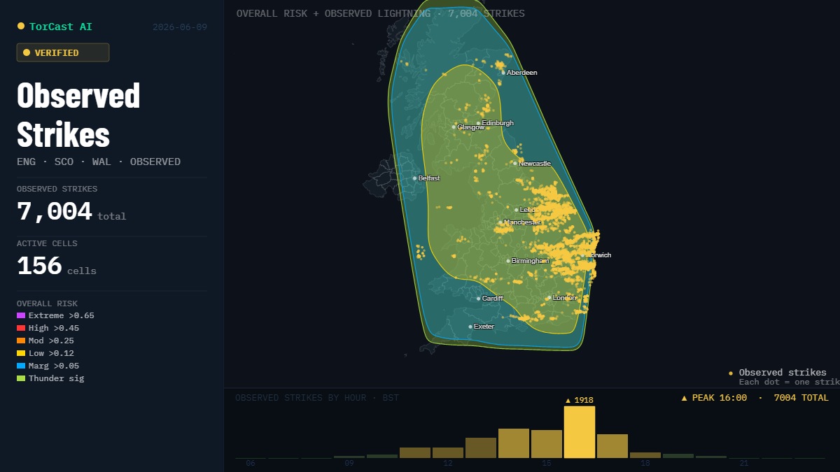
Jun 9
Verification: The Models increase in the low risk area this morning largely justified and overall verified well. Pleased with the Hour-by-Hour hit rate as storms largely fired in the low risk zones.
Tomorrow the highest risk area will likely be East Anglia again, but more on that shortly.
Jun 9
UPDATE: Slight expansion in the Low-Risk area South & South-West, and has reduced the Low risk in the North of Scotland on this mornings data ingest.

6
494
TorCast Ai retweeted

Jun 9
FastNet, a Machine Learning Weather Prediction (MLWP) model developed with @turinginst combines machine learning with physics-based modelling.
It is unlocking new forecasting capability, improving prediction of challenging features like daily temperature cycles and enabling earlier insight for heatwave decisions.

Last month FastNet, the AI weather model we're developing with @metoffice, predicted the high temps of May's heatwave 84hrs ahead.
It captured the highest midday temps more closely than the current operational physics-based global model.
Learn more: bit.ly/4i0s2b7

ALT Three heatmaps of the UK showing heatwave temperatures for 26 May 2026. The first heatmap shows the 'physics-based model' output - showing lower predicted temperatures than the 'FastNet' model map next to it, with the third map showing the observed weather at 12UTC on 26 May. Below the maps are the Met Office and The Alan Turing Institute logos with the text 'FastNet: Machine Learning Weather Prediction Model' to the bottom right of the graphic.
4
12
63
26,218
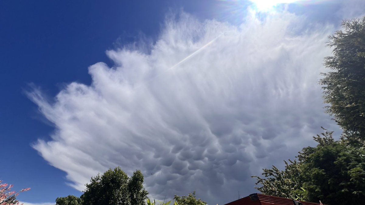
Jun 9
Amazing photo of Mammatus!!


1
5
205
TorCast Ai retweeted

June in Aberdeenshire Scotland..... Hail, Thunder, Huge amounts of hail and lightning. wish i was there @Petagna @UKStormUpdates @BBCScotland @TorCastAi @Arab_Storms @DundeeSat

1
1
5
362