Record cold continues across much of the Plains and spreads south over the next few days, with over 80 million people estimated to fall within areas under cold weather headlines. Additionally, a winter storm is currently tracking from the Ozarks to the southern Mid-Atlantic.
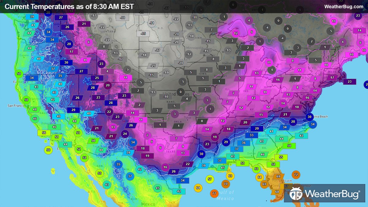
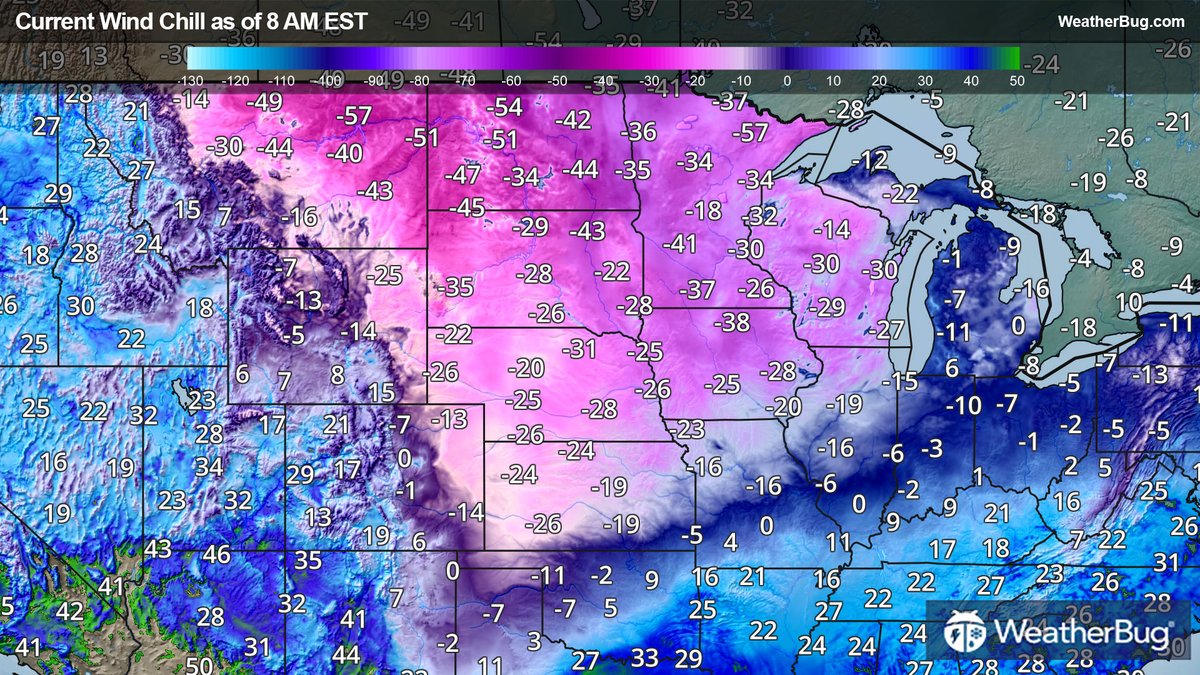
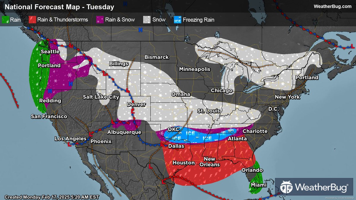
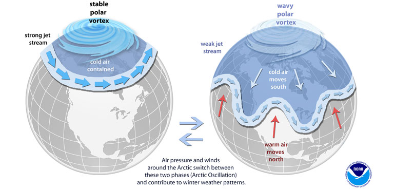
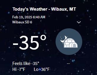
ALT Record cold likely in the Central U.S. this week
An Arctic air mass will plunge into the Central U.S. this week with high confidence for widespread, record-breaking cold. Through Friday, numerous daily records are likely to be broken across the Plains and Lower Mississippi Valley with some locations experiencing their coldest temperatures on record for so late in the season.
Dangerous wind chill temperatures
Wind chills between -30°F and -60°F are forecast across the Northern Plains, lingering for multiple days. These extreme conditions can cause frostbite within minutes. Sub-zero wind chills will likely extend as far south as Texas, Arkansas, and
western Tennessee and Kentucky.
Winter storm this week with snow and ice
Moderate to heavy snow will continue tonight across parts of Kansas and Oklahoma into southern Missouri and northern Arkansas. Up to a foot of snow will cause considerable disruptions to daily life.
A Mustang was swept away during severe floods in Panther, W. Va., on Saturday, February 15. It also took two sheds and destroyed a garage filled with many expensive tools.
Credit: Heather Bailey via Storyful
This is what we are seeing all over the OKC metro area. These crashes happened at I-35 northbound at 2nd Street. We are also working numerous jackknifed semis. The common denominator is drivers traveling too fast for the weather conditions.
A lake effect snow band produced up to 8 inches of snow across the Western SoTier yesterday afternoon and evening. Now that skies have cleared out, we can see why. Although Lake Erie is mostly frozen, there's still enough open areas and breaks in the ice to produce lake snow.
Tired of the cold and snow?? Well, this dog sure isn't! Video was taken in Hamilton, Ontario, Canada, on Monday, February 17.
Credit: @hauntedivys via Storyful
After an already active winter season, the latest in a series of winter storms will target areas from the central Plains to the Mid-Atlantic.
Find out how much snow and ice will fall here: bit.ly/412wD4Q
Great Lakes ice update for February 17, 2025: Combined 36% | Lake Superior 21% | Lake Michigan 24% | Lake Huron 50% | Lake Erie 86% | Lake Ontario 16% | #GreatLakes
This is an extended loop from Feb. 15–17 via @NOAA's #GOESEast 🛰️, which shows the powerful storm system that swept across the U.S. this past weekend. It produced devastating #flooding as well as #tornadoes and wind damage in multiple states.
#GOES16#TimelapseTuesday
Here are the latest Key Messages for the mid-February wintry blast that will bring record cold and dangerous wind chills to much of the central U.S. this week as a winter storm moves east from the central Plains to parts of the Mid-Atlantic and Southeast.
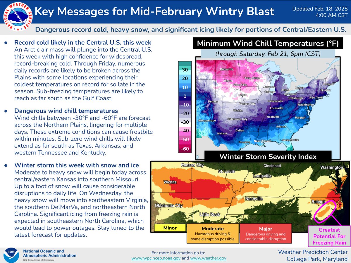
ALT An Arctic air mass will plunge into the Central U.S. this week with high confidence for widespread, record-breaking cold. Through Fri, numerous daily records are likely to be broken across the Plains with some locations experiencing their coldest temperatures on record for so late in the season. Sub-freezing temperatures are likely to reach as far south as the Gulf Coast.
Wind chills between -30°F and -60°F are forecast across the Northern Plains, lingering for multiple days. These extreme conditions can cause frostbite within minutes. Sub-zero wind chills will likely extend as far south as TX, AR, and western TN and KY.
Moderate to heavy snow will begin today across central/eastern KS into southern MO. Up to a foot of snow will cause considerable disruptions to daily life. On Wed, the heavy snow will move into southeastern VA, the southern DelMarVa, and northeastern NC. Significant icing from freezing rain is expected in southeastern NC, which would lead to power outages.
Dangerously #cold tonight. What you normally do to combat the cold isn't enough. Yeah, we are hearty Midwesterners, but this is more than "normal" kind of cold. Take is seriously and protect yourself, family and pets. #mnwx#iawx#wiwx
The lake-effect snowband that is dumping snow as far east as Connecticut can be traced all the way back to Lake Superior. That's nearly 800 miles long!! #winter@weatherchannel@weathernetwork
Incredible winds on Mt. Washington, NH today. Winds up to 161mph and wind chills to -63ºF observed!
Tropopause fold and intense pressure gradient are combining to generate the winds. This timelapse from the WIldcat webcam shows the clouds spilling over the Presidential Range
Weather extremes pop up across the U.S. on Tuesday, with particularly bitter cold temperatures, deep snow, and strong Mid-South thunderstorms entering the picture.
Story: bit.ly/3EAd4sX