
Hosted by Bonnie (@bonnster7) in Oklahoma & Bobby (@BobbyCorser) in Oregon. Proud member of #NWPM & @WRNAmbassadors. B Squared: Your Weather Podcast!
Joined June 2018
- Tweets 1,514
- Following 395
- Followers 136
- Likes 746
198 Photos and videos


Bonnie says she’s starting to see the first part of this winter storm move into Moore! Here we go!!
27

11 Jun 2025
Bonnie just texted saying that Oklahoma and meteorology legend Gary England had passed away. Gary was a calm voice to everyone who saw his coverage of the biggest storms that moved through Oklahoma. He inspired so many people in the meteorology world. He will be missed. @garyeOK
1
2
116
B Squared: Your Weather Podcast retweeted

11 Jun 2025
Rest in Peace to one of the greatest Meteorologist on this planet! Truely an Oklahoma Icon.

6
72
2,228
B Squared: Your Weather Podcast retweeted

11 Jun 2025
Former News 9 meteorologist Gary England – the Severe Weather God of Oklahoma – has passed away at the age of 85.
He was a pioneer in his field, and guided untold numbers of Oklahomans – this one included – through countless weather emergencies over the decades. RIP to a legend.

118
537
2,557
378,839

Longtime Oklahoma meteorologist Gary England dies at 85 | Click on the image to read the full story koco.com/article/gary-englan…
13
72
375
37,498
B Squared: Your Weather Podcast retweeted

28 Dec 2024
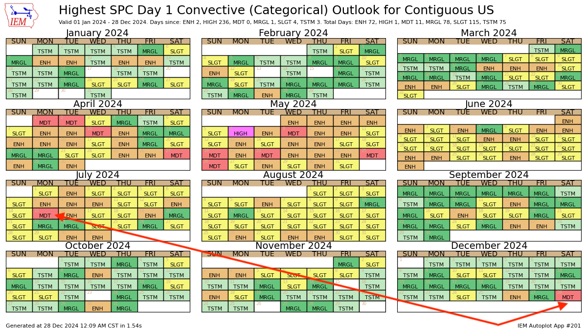
Today is the first level 4 out of 5 "moderate" #severe forecast from @NWSSPC anywhere in the U.S. in over 5 months (July 15).
Only 12th day this year with at least a level 4 risk.
Take this threat seriously if you're in the Deep South.
2
37
181
11,036
B Squared: Your Weather Podcast retweeted

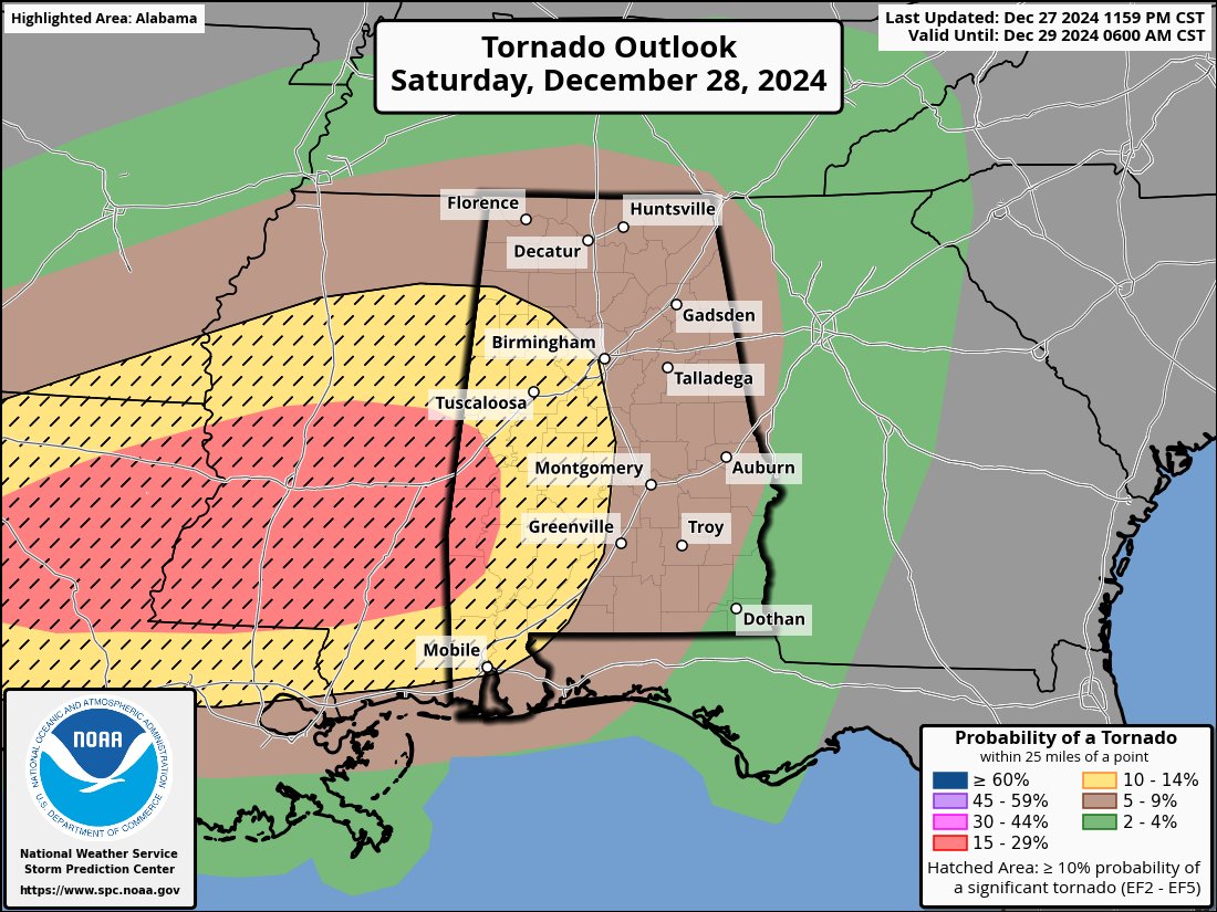
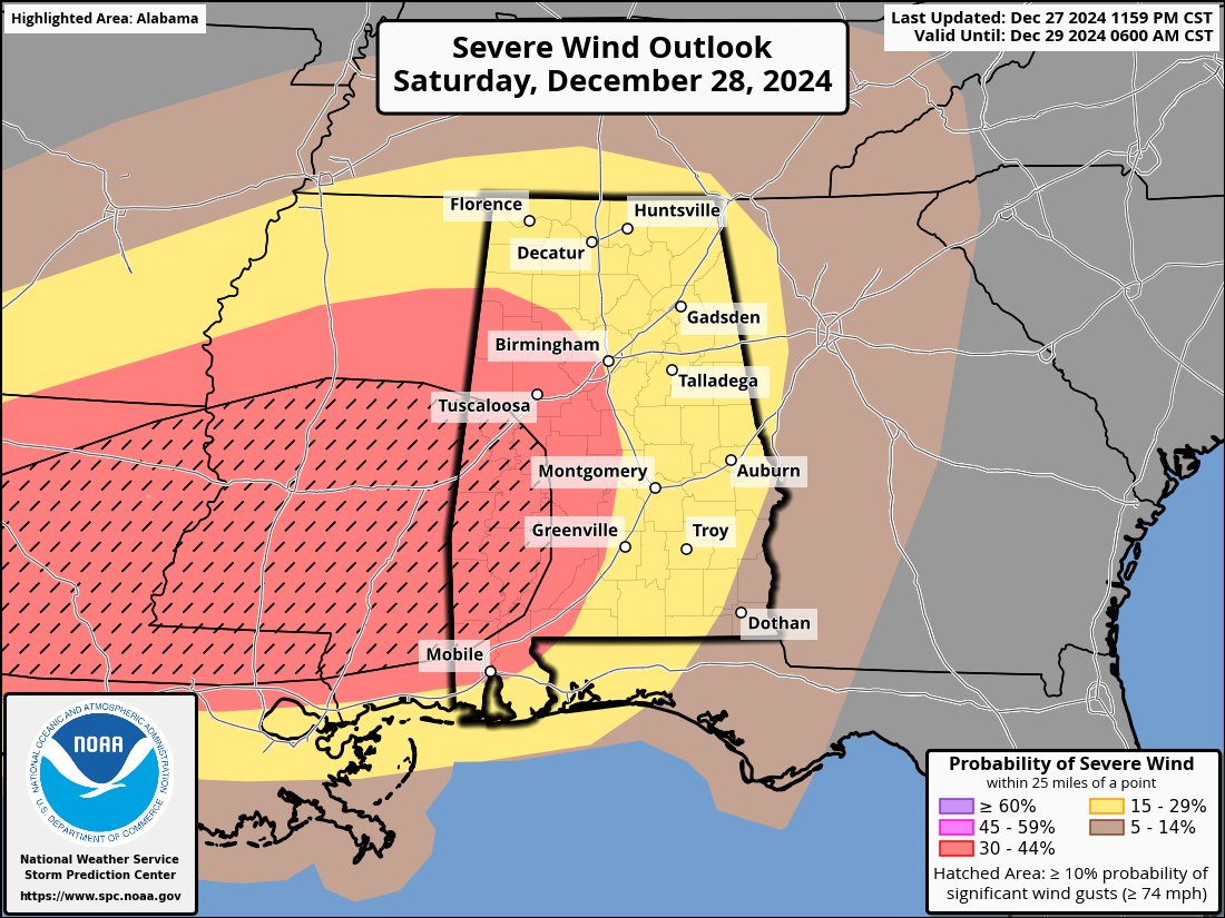
28 Dec 2024
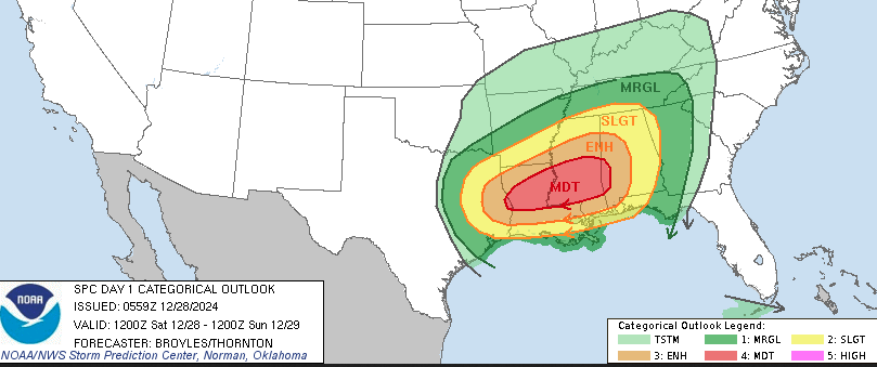
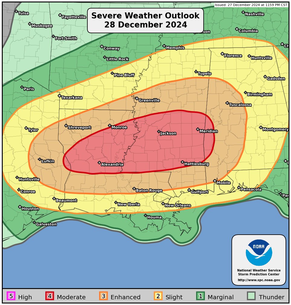
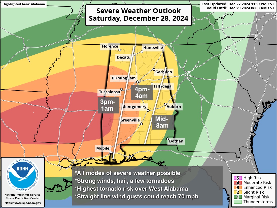
SIGNIFICANT SEVERE WEATHER THREAT AHEAD: A dynamic storm system will bring the threat of severe thunderstorms and tornadoes to parts of LA/MS/AL later today and tonight.
In Alabama, there is a "moderate risk" (level 4/5) defined for parts of Sumter, Choctaw, and Washington counties in West Alabama. An "enhanced risk" (level 3/5) extends over to Fayette, Selma, and Mobile. Most of the rest of the state is in a "slight risk" (level 2/5).
TIMING: A few isolated severe storms are possible in the 3 to 9 p.m. time frame, but high resolution models are suggesting these storms will be isolated. The "main show" will come late tonight from 9:00 p.m. through the pre-dawn hours Sunday. All storms should be out of Southeast Alabama by 8:00 a.m. tomorrow.
THREATS: Any isolated storms this evening and tonight will have to be watched for severe potential, but with the "main show" late tonight the highest concern is widespread straight line winds that could feature gusts to 70 mph in spots. This mass of storms will have potential to produce a good bit of tree and power line damage tonight.
Storms could also produce hail and a few tornadoes. The highest threat of long track tornadoes (EF-3 ) is in the "moderate risk" area across LA/MS and extreme West Alabama.
GRADIENT WIND: Ahead of the line of storms tonight, gradient winds (not related to thunderstorms) will ramp up, gusting to 40 mph in spots.
RAIN: Additional rain amounts of 1-2 inches are expected for much of Alabama through early tomorrow morning; for now major flooding issues are not expected.
CALL TO ACTION: Be sure you have a reliable way of getting warnings later today and tonight; a NOAA Weather Radio is the baseline for any home or business. On your phone, be sure and have emergency alerts enabled. Know the safe place in your home (small room, lowest floor, away from windows, and near the center of the house), and have a helmet for everyone (including adults)
If you live in a mobile home, know the location of the nearest shelter (or business that can serve as a shelter), and how to get there quickly. Have transportation available.
BE A HERO: If you are reading this, you pay attention to the weather. Take the time to share important weather information (especially tornado warnings) with family and friends with a text or phone call. You could be the only warning they get.
REMEMBER: Having a severe weather threat in Alabama in late December is nothing unusual. Our tornado season runs from November through May. No need to be alarmed or anxious; just pay attention to warnings, have a plan, and we will get through the this just fine together.
12
190
681
74,139
12 Aug 2023
It would have been hard to stop that fire with those conditions anyway...urban or rural.
12 Aug 2023

Having a state attorney general looking into it will not produce an optimum result. We need a National Disaster Review Board: mikesmithenterprisesblog.com…
Democratic Rep. Jill Tokuda admits they 'underestimated' Maui fire mol.im/a/12400403 via @MailOnline
90
B Squared: Your Weather Podcast retweeted

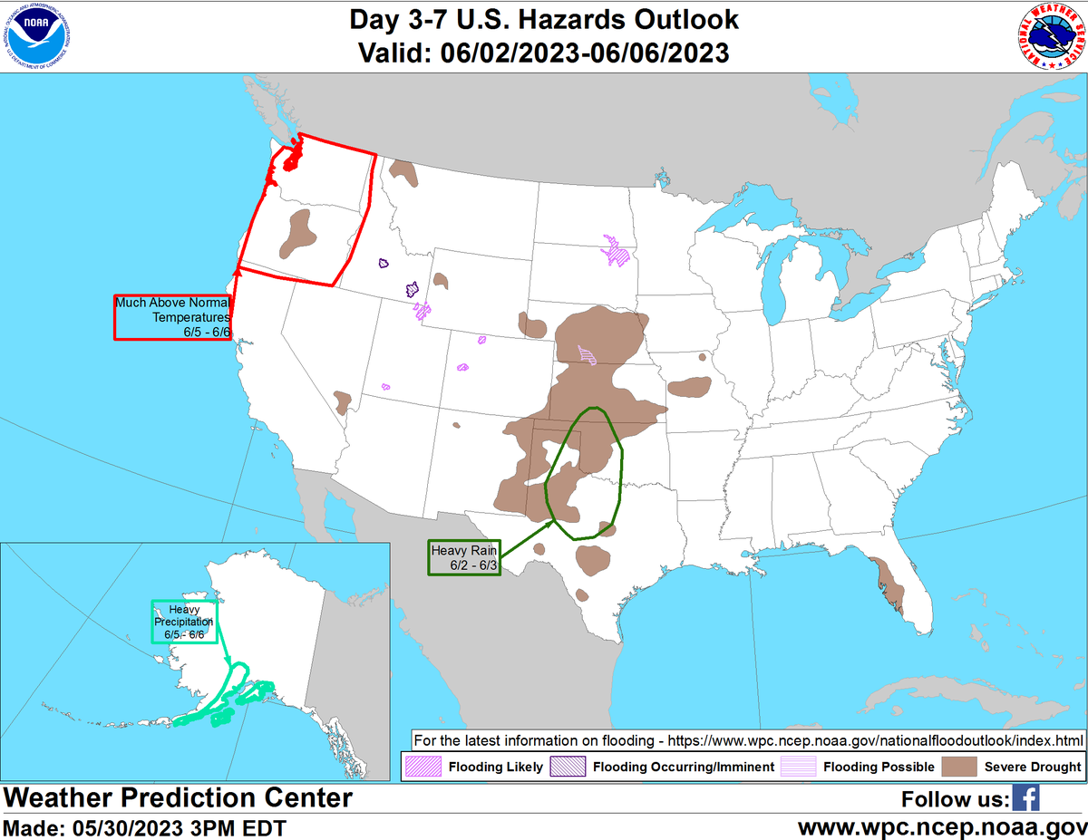
30 May 2023
An updated Day 3-7 Hazards Outlook has been issued. wpc.ncep.noaa.gov/threats/th…
13
23
9,919
B Squared: Your Weather Podcast retweeted

2 May 2023
On my way to the US customs office. License plate looks to be ready by Thursday storm chase
45
64
1,298
202,893
B Squared: Your Weather Podcast retweeted
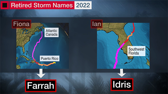
29 Mar 2023
After today's announcement from the @WMO, the most often retired #hurricane names since 1954 are:
- "I" storms: 13 times (not counting Iota 2020)
- "F" storms: 10 times
2022's retirees: #Ian and #Fiona.
Our slideshow of all 96 retirees since 1954: weather.com/storms/hurricane…
8
15
2,038
B Squared: Your Weather Podcast retweeted

6 Nov 2022
One of the Oklahoma Mesonet's weather stations recorded the fifth highest wind gust since 1994 in Idabel as a tornado ripped through the small town. If rated an EF-3, it will be the first EF-3 tornado in OK since 2019


10
22
B Squared: Your Weather Podcast retweeted

5 Oct 2022
Sending prayers and good thoughts to my weather best friend @bonnster7! Get well! @WeatherPodcast
1
2
28 Sep 2022
This is so cool!
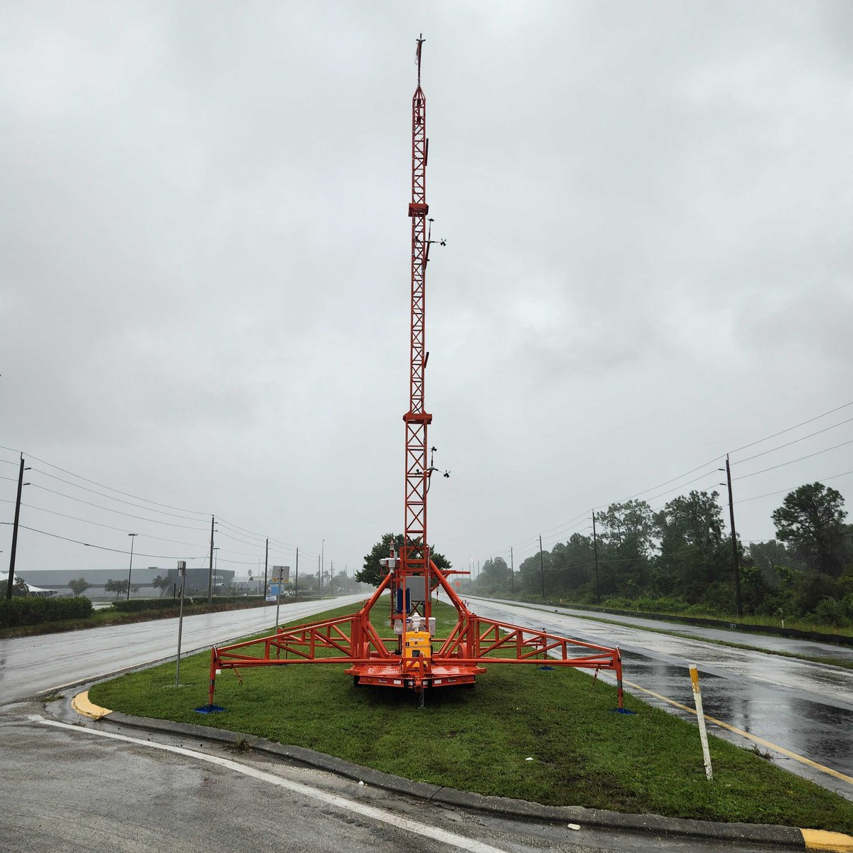
28 Sep 2022

University of FL program by Dr. Forrest Masters, in collaboration with WeatherFlow-Tempest. Placed right in the path of Hurricane Ian. Expected to get hammered soon....stay tuned.
1
B Squared: Your Weather Podcast retweeted

8 Aug 2022
1
3
25 Jul 2022
That's not good.
23 Jul 2022
This will be interesting to watch this afternoon!
23 Jul 2022

[2:45 PM 7/23] An organizing area of thunderstorms is expected to track across parts of N. IL this evening and has the potential to deliver all severe hazards to the region, including damaging straight line winds and a few brief tornadoes. #ILwx #INwx
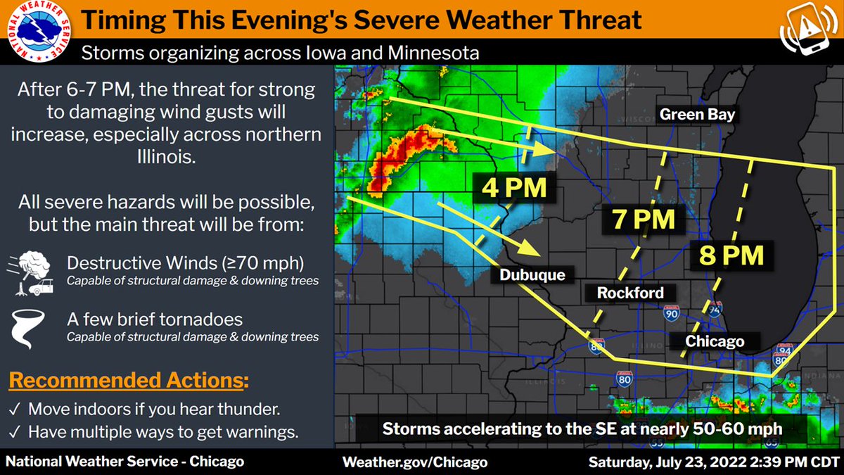
ALT An organizing area of thunderstorms is expected to track across parts of N. IL this evening and has the potential to deliver all severe hazards to the region, including damaging straight line winds and a few brief tornadoes. At this time, this threat should arrive into the Rockford area towards 7 PM, and the greater Chicago area by 8 PM, if not a little earlier. Winds in excess of 70 mph will be the primary threat.
23 Jul 2022
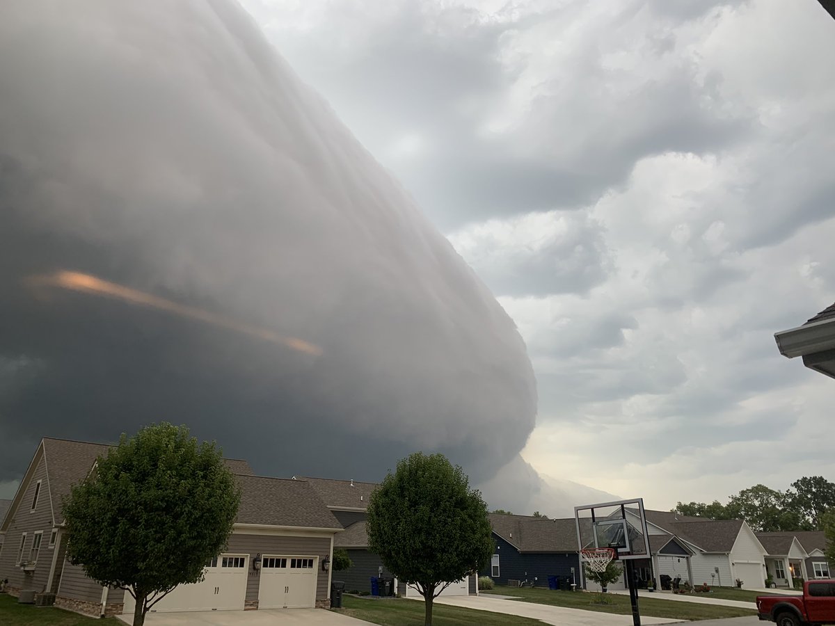
Text book shelf cloud

1