
Come for the snark, stay for the GIFs
Joined January 2011
- Tweets 121,252
- Following 984
- Followers 1,054
- Likes 108,915
7,095 Photos and videos


Pinned Tweet

Anyway.
End capitalism.
End imperialism.
Free Palestine.
Free Venezuela.
Free the global south.
Give all people the independence free from American/European/white colonialism.
ladbible.com/news/greta-thun…
2
3
7
1,581
a little corner 🐘🐳🌥️ retweeted

Carney's already sold us out... the fix is in.
JPM gets the YTZ expansion, Carney gets the war bank, and Ford, w McNaughton and Nigro, get Palantir Central - the Convention Centre-CNE-Ontario Place-whats left of islands.


🚨 Breaking 🚨
Will taxpayers be on the hook for the $5 billion airport expansion that will destroy the Toronto Waterfront?
The Toronto Port Authority says the expansion will be self financing, but with $17 million annual net revenue, how could they finance a $5 billion loan?
#ONpoli
#Cdnpoli
cbc.ca/news/canada/toronto/t…
13
83
226
10,043
a little corner 🐘🐳🌥️ retweeted

Thread 🧵
Citizens of Toronto you better get your shz together and fight if you want any waterfront left
#topoli #nojetsTO

Carney's already sold us out... the fix is in.
JPM gets the YTZ expansion, Carney gets the war bank, and Ford, w McNaughton and Nigro, get Palantir Central - the Convention Centre-CNE-Ontario Place-whats left of islands.
2
5
13
148
a little corner 🐘🐳🌥️ retweeted

Eric Lombardi is like Brad Bradford. Formerly fake progressive who is now trying on a right wing persona out of opportunism. I can guarantee you he is funded by interests who want to push for more privatization. He represents the worst of our political moment.
10
16
145
5,424
a little corner 🐘🐳🌥️ retweeted

NEW: A new survey of Ontario’s emergency room physicians suggests the majority are struggling with severe overcrowding, hurting the ability of some to see patients as quickly as they should. #Onpoli
globalnews.ca/news/11905090/…
4
42
69
2,643
a little corner 🐘🐳🌥️ retweeted

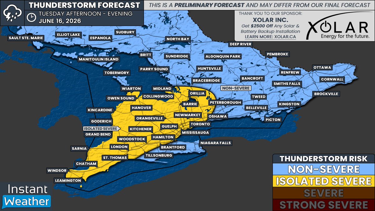
#ONStorm #ONwx ⛈️ Isolated Severe Thunderstorms Possible Across Southern Ontario on Tuesday
Heads up! We’re monitoring the potential for isolated severe thunderstorms across a large portion of Southern Ontario on Tuesday afternoon and evening.
This includes parts of Southwestern Ontario, the Golden Horseshoe, and Central Ontario, including areas around Lake Simcoe.
Scattered pop-up thunderstorms are expected to develop during the early to mid afternoon and continue into the evening. There is still some uncertainty regarding how intense these storms may become, but the environment appears supportive of a few marginally severe storms.
At this point, the primary threats appear to be damaging wind gusts and localized flash flooding, especially where slow-moving storms repeatedly track over the same area. Small hail is also possible with the strongest cells.
As for the tornado risk, it remains quite low based on the latest data, but cannot be completely ruled out. The greatest potential would be across Deep Southwestern Ontario, including Windsor, Leamington and Chatham, where a somewhat more favourable environment may develop. Even there, confidence remains low.
We’re currently working on a detailed forecast that will be published later tonight or early Tuesday as newer data becomes available. In the meantime, we’ve put together a preliminary map to give you an early look at where storms could develop.
The risk area currently includes Windsor, Chatham, Sarnia, London, Goderich, Woodstock, Kitchener, Hamilton, Guelph, Orangeville, Toronto, Newmarket, Barrie, Orillia, Collingwood and Owen Sound.
Keep in mind that any severe storms that develop are expected to be very isolated. Not everyone within the highlighted area will see a storm, and the vast majority of thunderstorms on Tuesday should remain below severe limits.
More details soon!
- Brennen
3
24
76
6,557
a little corner 🐘🐳🌥️ retweeted

“We suspect significant amounts of communication have already happened between federal/provincial govts, as well as 3rd parties regarding the airport expansion & what's happening now is 'window dressing' to make it look if there's actual real consultation & engagement happening."


Indigenous group seeking consultation, records on Billy Bishop expansion plans thetrillium.ca:443/news/indi…
4
35
69
1,067
a little corner 🐘🐳🌥️ retweeted

Though he before told us Doug Ford had evolved, Martin Regg Cohn now shifts from brutal character attacks on poor old Nate to loves notes for his new crush

5
5
22
1,080
a little corner 🐘🐳🌥️ retweeted

Real concerns by First Nations that feds have already decided to back Ford. Indigenous group seeking consultation, records on Billy Bishop expansion plans thetrillium.ca/news/indigeno… via @Thetrilliumca
6
49
82
894

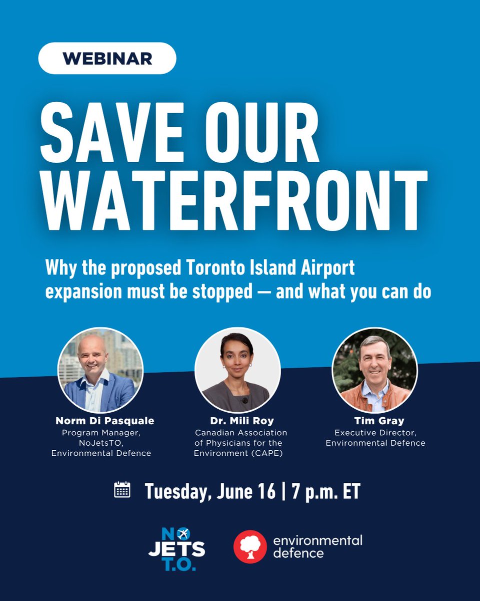
Are you concerned about the proposed jet expansion at the Toronto Island Airport and the devastating impact it could have on Toronto's waterfront, residents and the environment?
👉 This free webinar is a must-attend: us02web.zoom.us/webinar/regi…
#SaveOurWaterfront #CdnPoli #TOpoli
55
65
2,164
a little corner 🐘🐳🌥️ retweeted

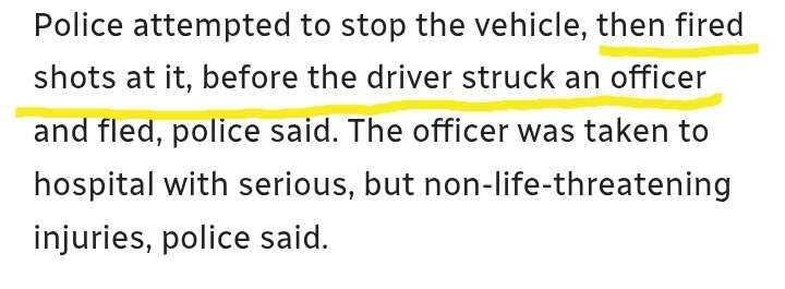
Official procedure of the Toronto Police Service is to not fire at a vehicle which is presenting a hazard to police and/or the public, as this is considered "ineffective": tps.ca/media/procedures/2598…
The public deserves further context on why this response was deployed.
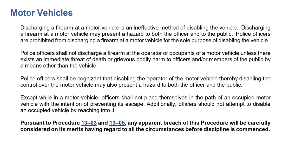

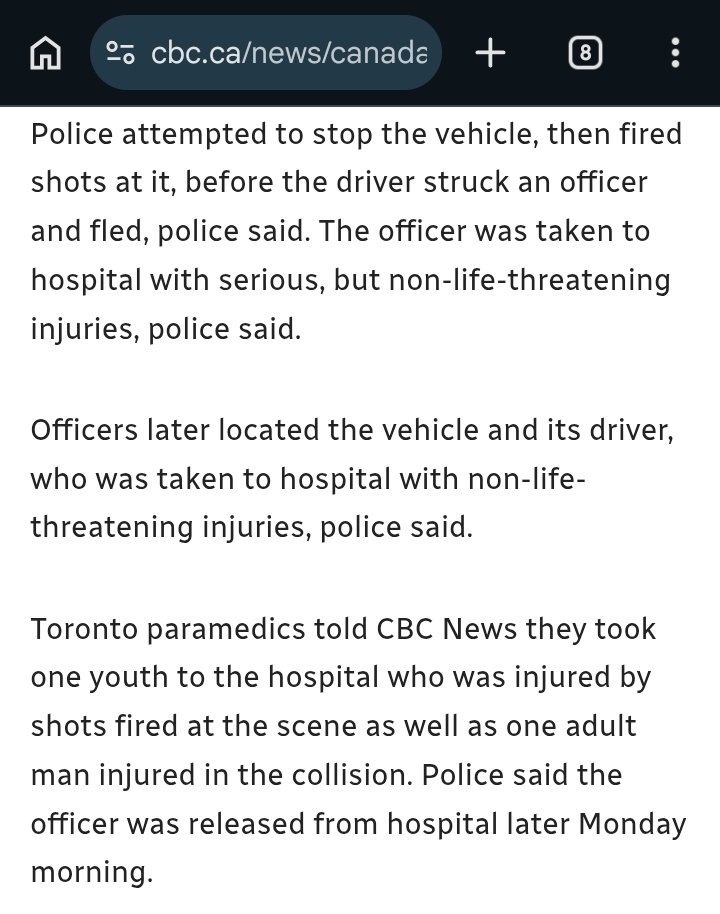
OFFICER INJURED:
Donlands Ave & O’Connor Dr
1:04am
- police responded to a call for a theft of vehicle
- officers attempted to stop the vehicle
- officers fired their firearm toward the vehicle
- the vehicle struck an officer
- the vehicle then fled the scene
- officers located the vehicle and the driver
- the driver of the vehicle was transported to hospital with non-life-threatening injuries
- one suspect remains outstanding
- no suspect description
- officer transported to hospital with serious but non-life-threatening injuries
- SIU has invoked their mandate
#GO1236224
^se
23
56
218
9,322
a little corner 🐘🐳🌥️ retweeted

She was right.


Jun 15

She was right then, and is right now.
PS employees of Palantir helped to set up Cambridge Analytica
3
9
344
a little corner 🐘🐳🌥️ retweeted
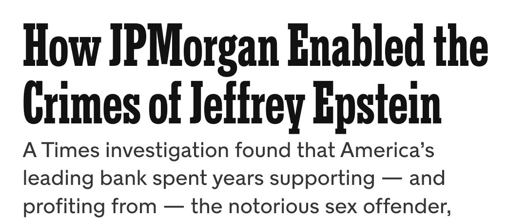
JP Morgan
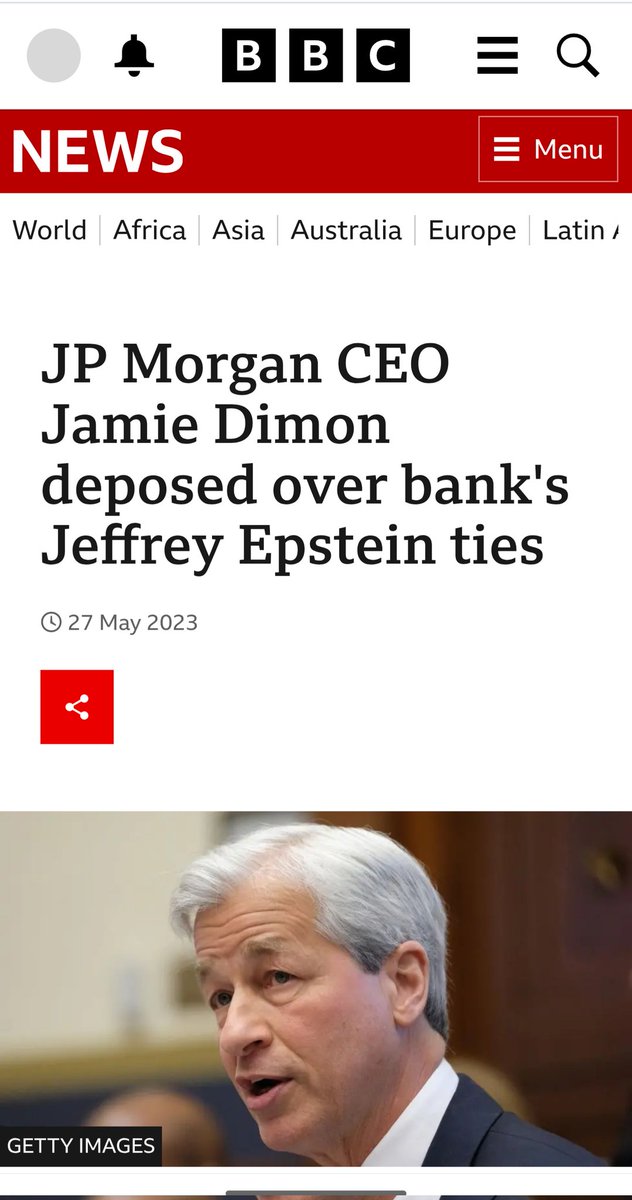
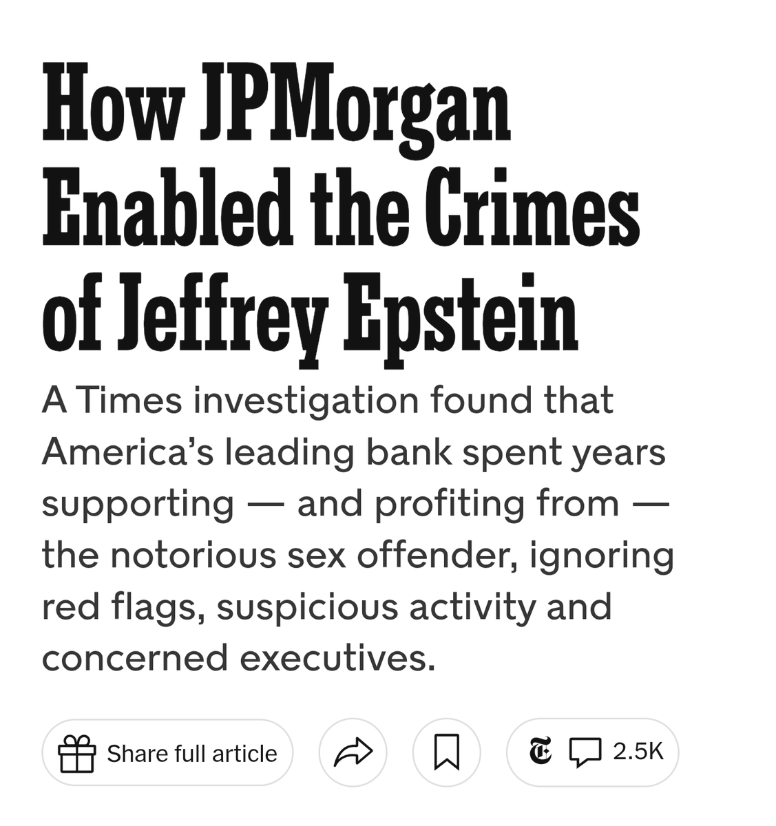

JP Morgan owns the airport terminal on Toronto Island. They’re lobbying HARD for the runway expansion that will wreck the waterfront.
They’ve now gone into PR crisis mode.
This spin is revealing tho - Carney met with JPM’s CEO in NYC. The fix is in
#cdnpoli
theglobeandmail.com/business…
2
78
107
2,781
a little corner 🐘🐳🌥️ retweeted

Should have been missed playoff teams in the Gold plan order, expansion teams and then playoff teams in the order they went out in the playoffs. New York and Toronto should be picking ahead of the expansion teams
2
2
55
1,167
a little corner 🐘🐳🌥️ retweeted

13h
New: Doug Ford’s government has been planning for a new multibillion-dollar convention centre, but won’t say how.
#onpoli
thetrillium.ca/insider-news/…
7
37
46
5,811
a little corner 🐘🐳🌥️ retweeted
Reminder: Official procedure is to use vehicles to block the car, not your body (we've seen officers hit how many times recently?), and to never fire upon a vehicle unless use of force has been authorized AFTER an officer has been injured.
1
5
26
883
a little corner 🐘🐳🌥️ retweeted

Happy Monday.
We have important work to do. Let's get on with it.

3
9
358
a little corner 🐘🐳🌥️ retweeted

The federal government shut out its own climate science and policy advisors while gutting Canada’s environmental protections in favour of oil and gas, parliamentary committee hears thenarwhal.ca/carney-canada-…
7
85
91
1,772
a little corner 🐘🐳🌥️ retweeted
On 9 March 1912, Helen Margaret Spanton was sentenced at Bow Street Magistrates’ Court to two months imprisonment with hard labour for damage to government property (breaking a window) valued at 3 shillings during protests by suffragettes in London.

The Lady Chief Justice said proscription of Palestine Action “struck a fair balance” and that PA is not a peaceful civil disobedience group like the Suffragettes
3
6
17
680
Always follow the money.
@corruptario
Carney's already sold us out... the fix is in.
JPM gets the YTZ expansion, Carney gets the war bank, and Ford, w McNaughton and Nigro, get Palantir Central - the Convention Centre-CNE-Ontario Place-whats left of islands.
4
61
The provincial BradBrad campaign. @corruptario


1
5
7
286