
An enginner, agronomist, with a special affection to Geoprocessing and Remote Sensing.
Joined April 2009
- Tweets 387
- Following 347
- Followers 172
- Likes 2,396
12 Photos and videos


Diego Hemkemeier retweeted

29 Aug 2023
#Copernicus for #snow and #ice monitoring ❄️
Snow has been falling over the #Andes Mountains 🌨️
Fresh snow near Santiago and Concepción, #Chile 🇨🇱, as seen by #Sentinel3 🇪🇺🛰️ on 27 August ⬇️
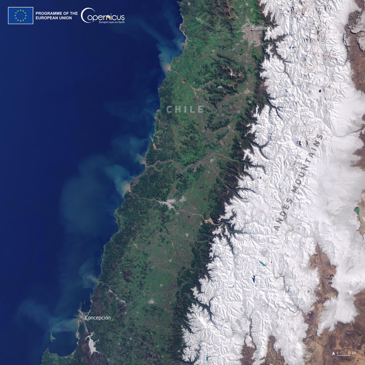
ALT Satellite image of the Andes Mountains covered with snow and the cities of Santiago and Concepción nearby.
3
42
126
13,353
Diego Hemkemeier retweeted

22 Feb 2023
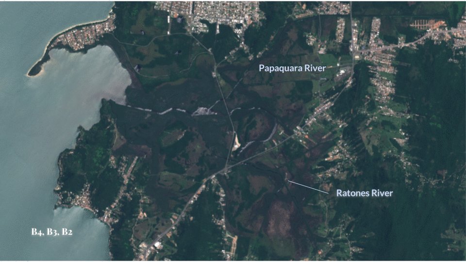
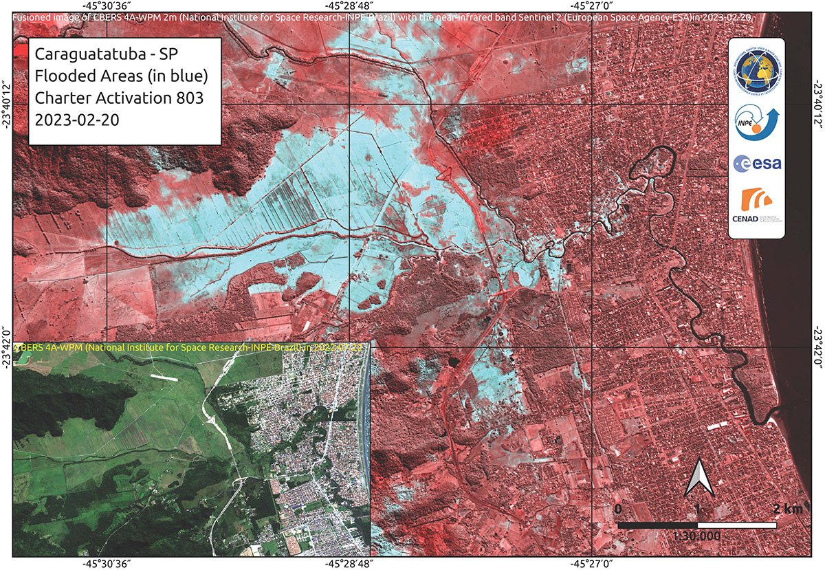
Our first map of the floods in Brazil combines CBERS-4 and #Sentinel2 images to estimate flooded areas at Caraguatatuba: bit.ly/3YTXaPl
17
48
6,661

We mark the passing of the legendary Pelé, known to many as the king of the "beautiful game." This image of a spiral galaxy in the constellation Sculptor shows the colors of Brazil.

ALT Image of a spiral galaxy with spiral arms dotted with blue stars of varying intensity. The core of the galaxy is brightest and that's where the stars appear yellow-green. The image was taken by the Galaxy Evolution Explorer satellite, or GALEX. Credit: NASA/JPL-Caltech
1,331
18,434
105,008
8,456,136

13 Dec 2021
Rains in the state of Bahia (Brazil) recorded by @CopernicusEU Sentinel 2. Satellite monitoring is an important ally in disaster resilience. @sentinel_hub @esa @AschbacherJosef @governodabahia
7
18
Diego Hemkemeier retweeted

12 Apr 2020
Qualidade do ar melhorou em Santa Catarina durante a quarentena, mostra Instituto ndmais.com.br/noticias/quali… via @ND_mais_ #noticiascartograficas bit.ly/newscarto
1
2
Diego Hemkemeier retweeted

12 Apr 2020
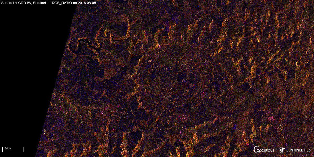
3D 🌋eruption plumes of Nevados de Chillán,
#Chile 🇨🇱 2020-04-10
Parallax🛰️Sentinel-2 bands offset B02 to B12
Transformed and expanding 🌍Earth's energy,
and rising to the skies 🌟... since it's Easter!
At @CopernicusEU @sentinel_hub @CopernicusLand
#volcanoes #geology
1
29
68
Diego Hemkemeier retweeted

6 Apr 2020
.@RUS_Copernicus webinar: Pollution Monitoring with @CopernicusEU Sentinel-5P🇪🇺🛰️.
This webinar will focus on multi-temporal evaluation of #NO2 over a study area, with #Python (xarray).
🗓️Application deadline: 15th April 20
🗓️Webinar date: 16th April 20
bit.ly/2Xfws6K
18
28
Diego Hemkemeier retweeted

12 Jun 2019
The #reanalysis of atmospheric composition produced by @CopernicusECMWF Atmosphere Monitoring Service atmosphere.copernicus.eu allows us to study past events. Here we see transport of CO at 850 hPa from the Indonesian #wildfires in Sept 2015. @m_parrington @CopernicusEU
4
72
123
Diego Hemkemeier retweeted

10 Jun 2019
A plume of #Sahara desert dust is shown crossing the Atlantic as far as the #Caribbean over the coming days in the latest #Copernicus Atmosphere Monitoring Service (atmosphere.copernicus.eu) forecast visualized by @windyforecast. @CopernicusECMWF @ECMWF @CopernicusEU @WMO
5
60
113
Diego Hemkemeier retweeted

8 Jun 2019
We are preparing six new Sentinel missions for decision by our @esa member States at the Space19 Ministerial in November. A thermal infrared mission is one among them - see some of the benefits it will bring @ESA_EO bbc.com/news/science-environ…
3
64
154
The @Space_Station is the perfect place to view a sunset. In fact, the station orbits the Earth every 90 minutes — meaning this sunset you see is actually one of 16 the station residents see in a day. Take in the view and see where the station is flying: go.nasa.gov/2Mp0Pnm
282
2,990
12,619
Diego Hemkemeier retweeted

31 May 2019
O satélite sino-brasileiro CBERS-4A já está na Academia Chinesa de Tecnologia Espacial (CAST), que é responsável por 50% do desenvolvimento do Programa CBERS, assim como o INPE.
O Programa CBERS nasceu de uma parceria inédita no setor técnico-científico espacial firmada em 1988.

12
38
302

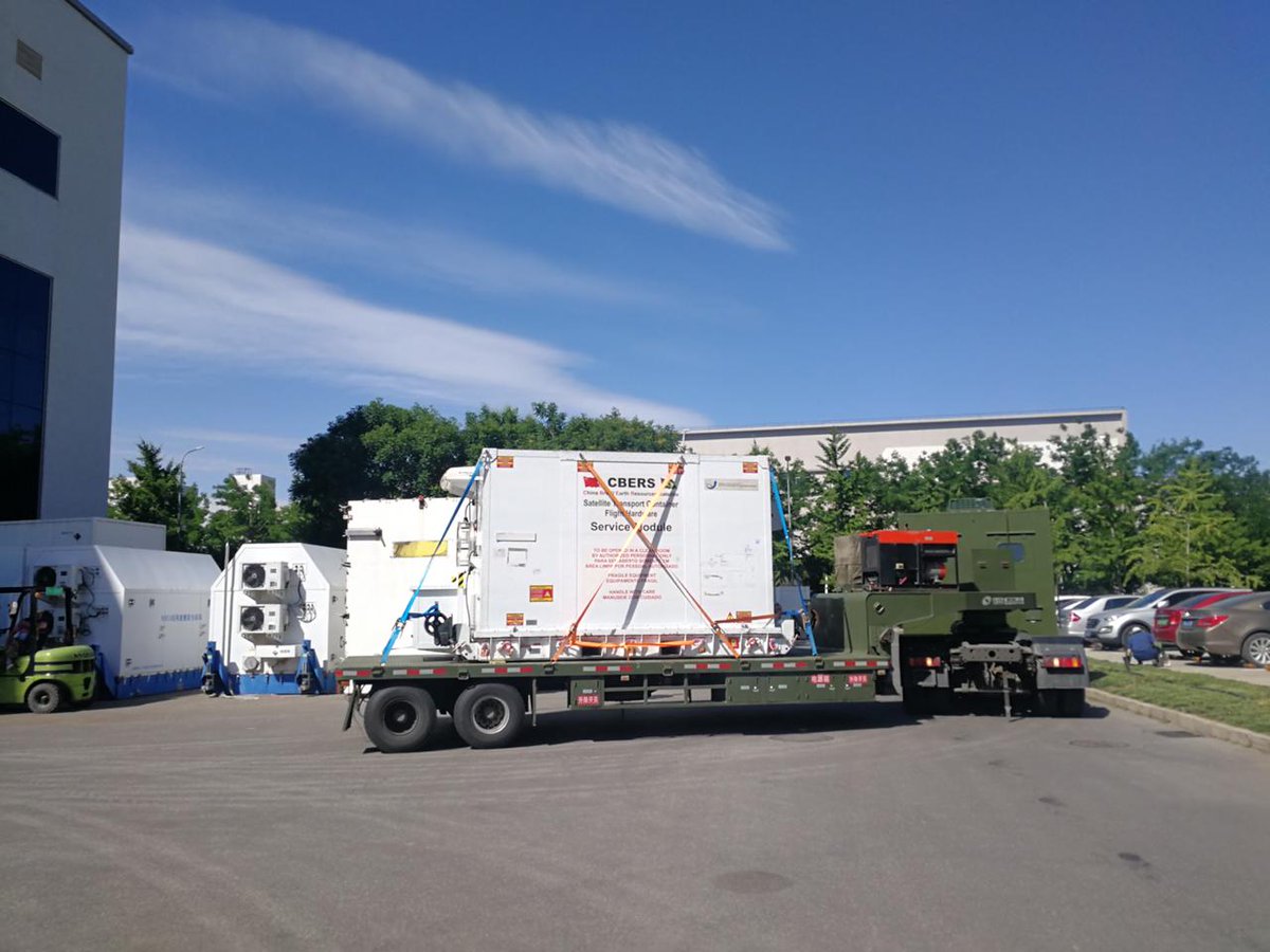
Boeing 747-400F da Air Bridge Cargo pousou aqui em #SãoJosédosCampos ontem para transportar o satélite Sino-Brasileiro CBERS-4A para Pequim.
🛰️🛬
#CBERS4 #sensoriamentoremoto #remotesensing #Boeing747
28 May 2019

Confira imagens do belo 747-400F da AirBridgeCargo em São José dos Campos.
ponteaerea.net/2019/05/28/bo…
4
17
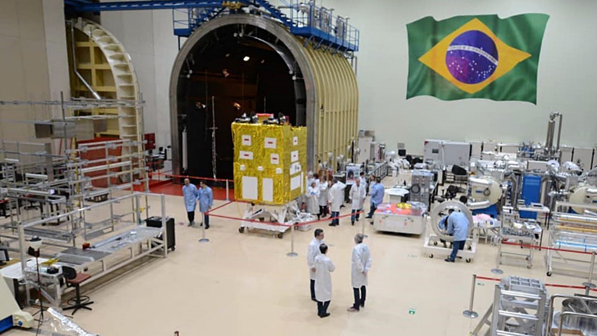
O satélite Sino-Brasileiro #CBERS4A está pronto para o transporte à #China.
info em instagram.com/p/Bx2B945DDnM
#sensoriamentoremoto #remotesensing
4
16
Diego Hemkemeier retweeted

19 May 2019
The importance of retrieving air temperature from satellite-based products.
The benefits are also seeing in other fields like #epidemiological and #transportation studies.
My #PhD was about it. Predicting #London's Tmax from #satellite-based #MachineLearning #modelling.
18 May 2019

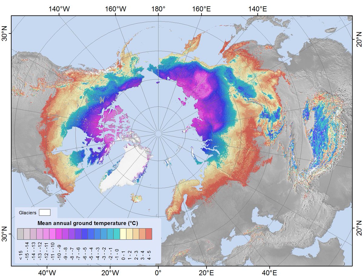
Research that uses data from satellites on ground temperature between 2000 and 2016 has resulted in the first global map of #permafrost at a spatial resolution of 1 km, and was published recently in Earth Science Reviews. Read more about it: esa.int/Our_Activities/Obser…
4
9
Diego Hemkemeier retweeted

1 Apr 2019
#AI, #DeepLearning, and the challenges of building the right data set from @ScottSoenen in the latest post to the Capella blog.
bit.ly/2uFn64U
Subscribe to our monthly newsletter for more delivered to your inbox: bit.ly/2JYcb0s
10
29
Diego Hemkemeier retweeted
3 Apr 2019
Happy Birthday dear #Sentinel-1A🇪🇺🛰️🎂
#Sentinel1 A is the pioneer of our Sentinel fleet, the first one launched on April 3 back in 2014
After 5 years, we have 7 Sentinel in orbit🛰️🛰️🛰️🛰️🛰️🛰️🛰️
4
155
493
Diego Hemkemeier retweeted

1 Apr 2019
For those with an appetite for C-band SAR Data
Open data: over 36,000 historical RADARSAT-1 satellite images of the Earth now available to the public - Canada.ca canada.ca/en/space-agency/ne…
4
37
71
Diego Hemkemeier retweeted

27 Mar 2019
Wildfire🔥 near Marinhas #Portugal🇵🇹 26 March 2019 Natural colors IR highlights #Copernicus #Sentinel-2A🛰️ Full-size: flic.kr/p/2dWuxLv #wildfire #RemoteSensing
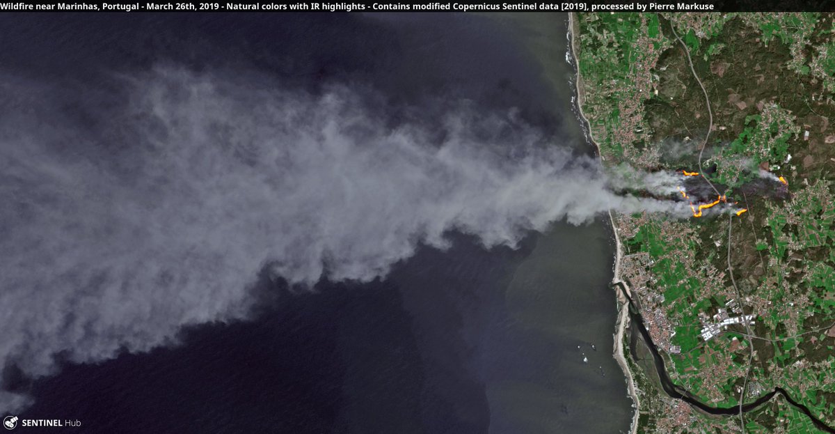
ALT Wildfire near Marinhas, Portugal. Copernicus/Pierre Markuse
2
41
71