
Joined June 2016
- Tweets 101,976
- Following 1,516
- Followers 1,809
- Likes 87,429
11,924 Photos and videos


✨ɐɹo˥ ✨|💛| retweeted

Jun 13
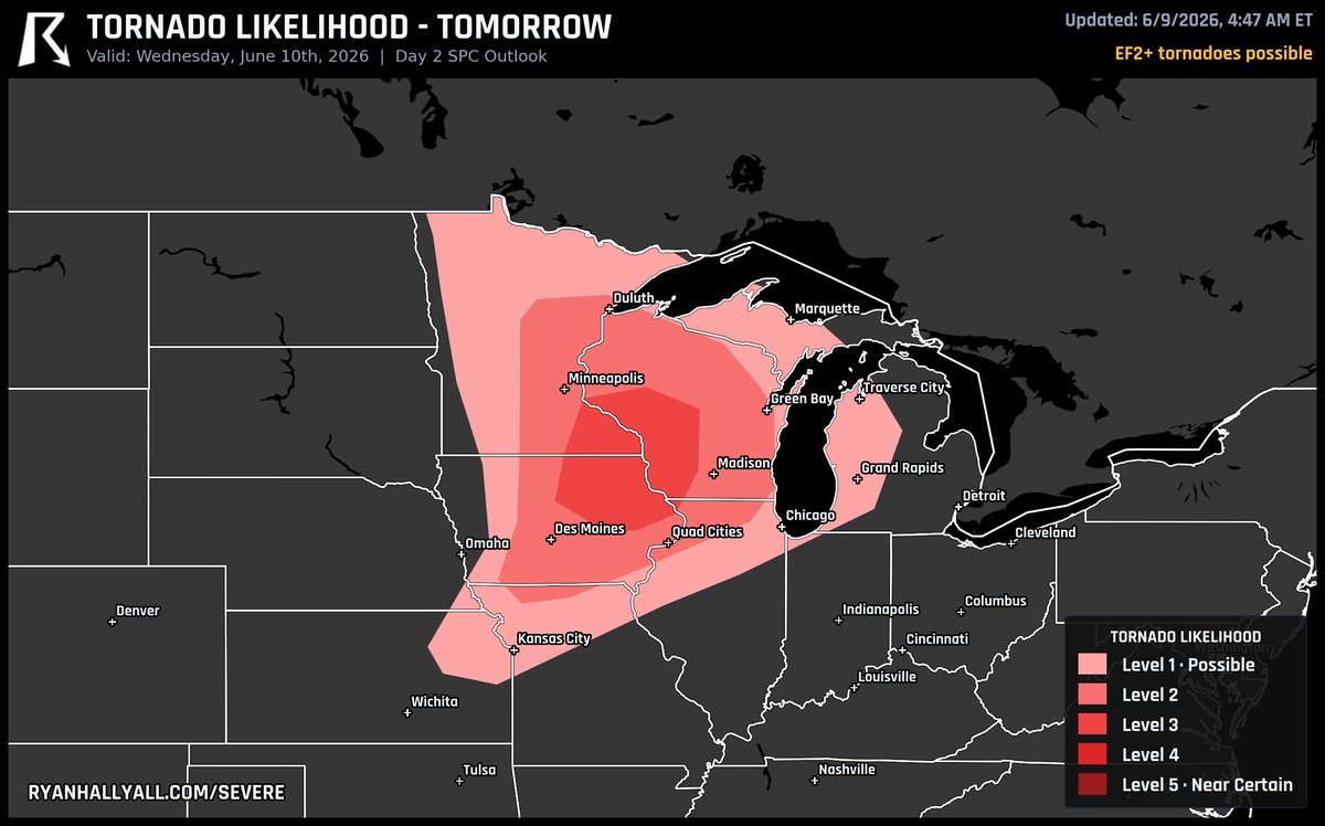
The most likely place in the USA to see a tornado tomorrow is around Philadelphia, PA, Washington, DC, and Baltimore, MD. This is a Level 1 risk for tornadoes.

95
249
3,676
339,811


Jun 12
some of yall are insufferable my god
Jun 11

she's pushing 40 and still obsessed with acting like a teenager my god she needs to grow up we're tired
1
3
120
Jun 11
"but did you die?" is diabolical 😆

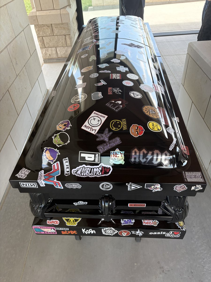
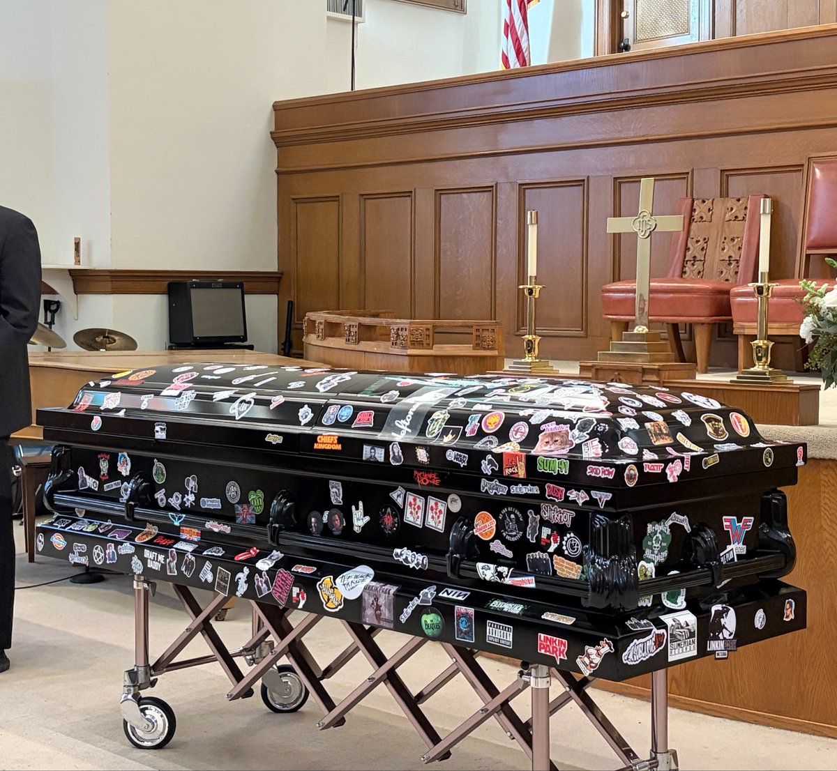
put my brother to rest this week 💔 he used to joke about making people put band stickers on his casket and throwing candy inside. never thought that day would come so soon but we made sure he had the most punk coffin in history
1
2
163
Jun 11
all of your bills show exactly who you are. someone that despises kids and don't want what's best for their constituents.
you need to go quietly & expeditiously. 👉🏻
Jun 10

With @RobSandIA, it’s all an act. This shows exactly who he is.
It’s never been about “better and truer,” it’s always been about politics and power.
15
Jun 11
this ish hurts my soul. knowing my cousins boy is going through what other kids haven't survived feels really defeating. 💔😭
Jun 11

Jalen Brunson post Game 4: "Before we start…
My thoughts & prayers are with a friend of mine I got to meet last week. Jonathan from North Carolina. From Make a Wish Foundation
They asked me to make a video. But something told me to Facetime…
I got the pleasure to do so…Quick call but well worth it.
My thoughts and prayers are with him and his family…
May God rest his soul"
(Reporter asks question)
Jalen (can't answer): "Sorry…"
46
Jun 11
every weekend in august i have •sOmeThiNg tO dO•
is this what being an adult is like? i want a refund.
2
7
64
Jun 11
mother nature needs to calm tf down. 6am? nah sis, go back to sleep. 😭
Jun 11

Tornado Warning for Iowa until 6:15 AM CDT. An observed tornado is on the ground. TAKE COVER NOW! We're tracking this LIVE on YouTube: youtube.com/watch?v=rqHW2Hhg…

4
41
✨ɐɹo˥ ✨|💛| retweeted
Jun 11
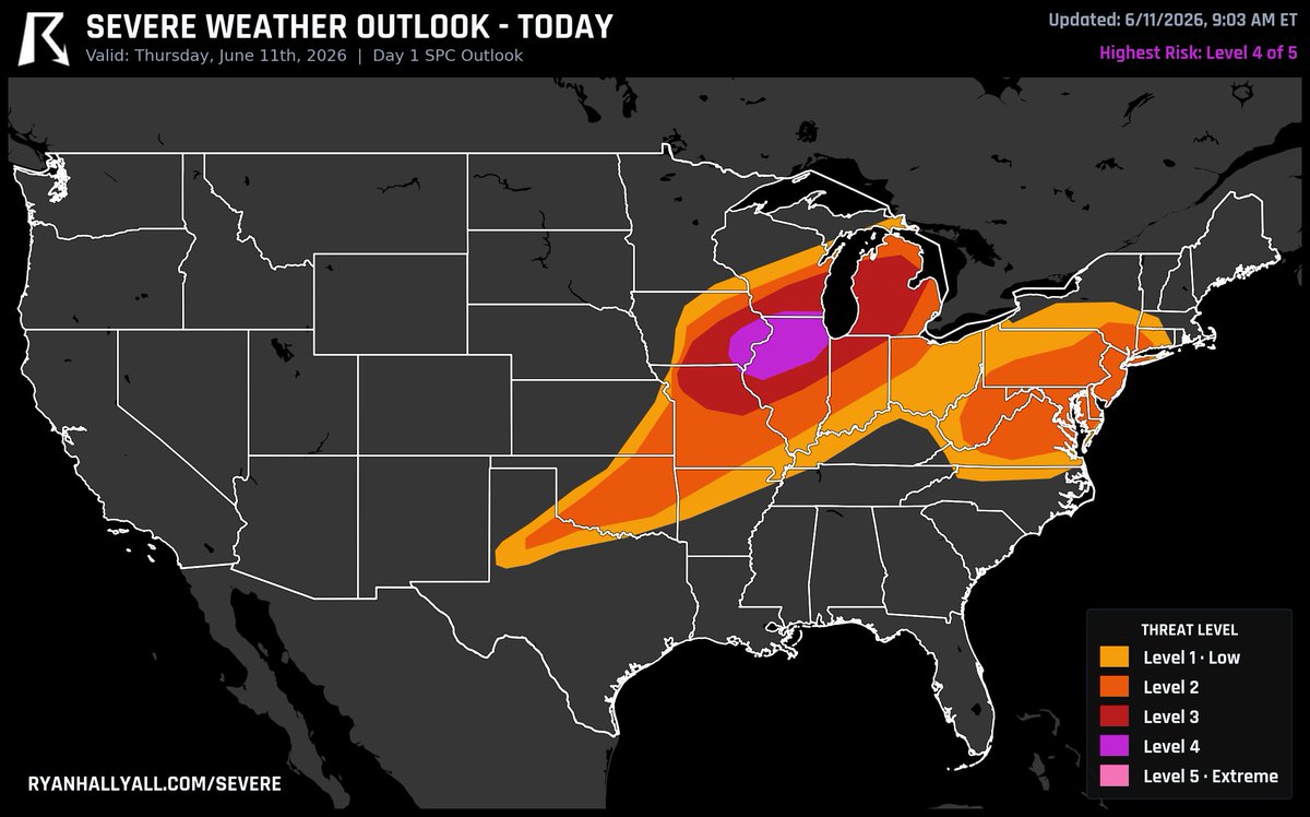
🚨 The Storm Prediction Center just bumped eastern Iowa and northern Illinois up to a Level 4 of 5 for today.
This is already in motion. A bowing line of storms that fired overnight has a history of severe wind gusts from Nebraska into Iowa, and it's pushing east-northeast through midday. As it does, the tornado risk picks up, not just the wind.
Then comes round two. As the cold front fires new storms this afternoon and evening, the low-level jet cranks back up and the line marches toward Lake Michigan, across Illinois, Indiana, and Lower Michigan.
Damaging winds are the headline, but strong tornadoes are on the table too. If you're anywhere from eastern Iowa through Chicago and into southern Wisconsin, today is the day to keep your phone close and your plan ready. We'll be LIVE on this.
48
229
1,841
220,016
Jun 11
my husband "something something mountain lions, just be careful walking out alone at night"
me "i'll punch a mountain lion in its throat idgaf"
him:
33
Jun 10
she doesn't get shit. she is me. 😒
Jun 9

Ladies… do you tip your hairstylist?
40
Jun 9
no, they're not.
Jun 9

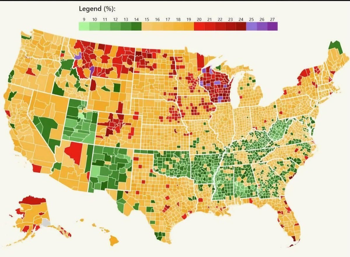
US counties with the highest and lowest rates of excessive drinking
Wisconsin people (Wisconsinites?)...are yall ok?
1
6
147

✨ɐɹo˥ ✨|💛| retweeted

The constitution of Iowa requires that a person be a resident of the state for at least two years prior before they can be elected as Governor.
This leaves Democrat Rob Sand as the only eligible candidate on the ballot.
Jun 8

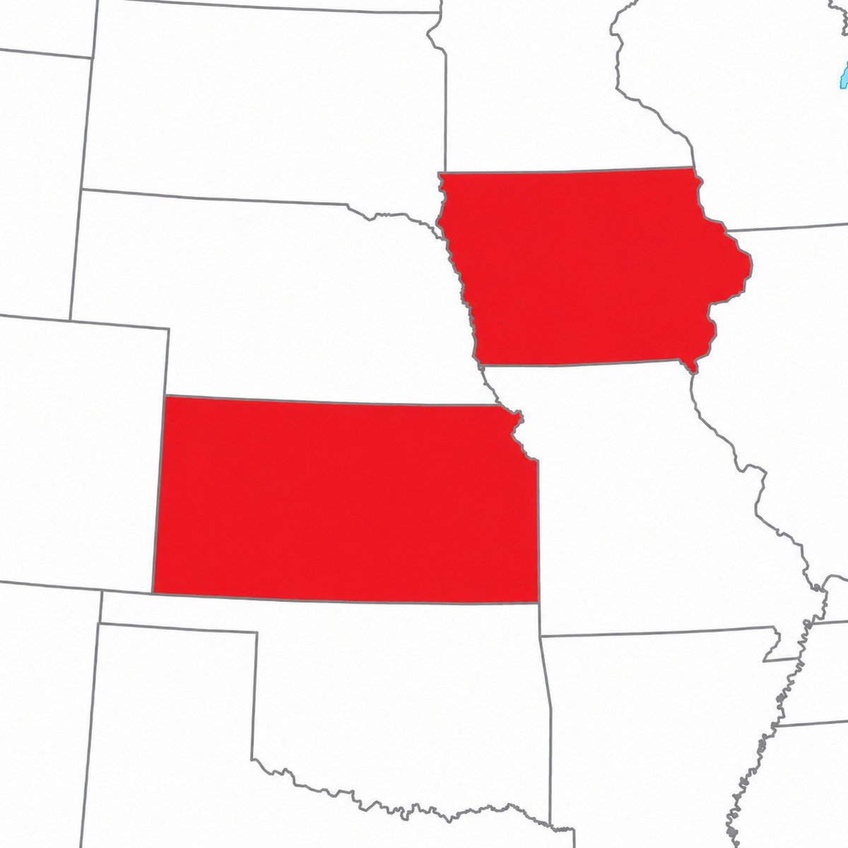
New reporting reveals Republican nominee for Iowa Governor Zach Lahn lives full time in Kansas.
Lahn says he plans to move to Iowa only if he is elected.

139
3,605
24,166
1,192,506
Jun 9

The single best shot at a tornado tomorrow is around Cedar Rapids, Charles City, and Decorah, Iowa.
Storms fire as supercells in the afternoon with 50 to 60 kt of shear and a strengthening low-level jet feeding right into eastern Iowa. That combo can spin up a few strong EF2 tornadoes before the line takes over with very large hail and 75 mph winds.
This is a Level 3 setup.
1
1
74
Jun 9
🎗️✨🎗️✨🎗️✨🎗️
fighting a battle at 13y that nobody should fight, let alone a kid. the fight gets lonely & hopeless.
while worried about all of his treatments he's worried he'll never play football again, also.
he could really use some positivity to uplift his spirits as he embraces the next few weeks. 💛
Jun 8

yall have an opportunity to do the wildest thing (by wildest i mean best) 🎗️✨💛🥹
as current @HoustonTexans (& former @CycloneFB players🌪️), it would bring great joy to my 13yo cousin, who is fighting ewing sarcoma🎗️here in iowa, to receive words of encouragement from players of his fave @NFL team. 🏈
(he's a cyclones fan too💛❤️)
@NoelJaylin13 @JaydenHiggins3 @XBH__8
1
2
68
✨ɐɹo˥ ✨|💛| retweeted

Jun 8
New reporting reveals Republican nominee for Iowa Governor Zach Lahn lives full time in Kansas.
Lahn says he plans to move to Iowa only if he is elected.
452
3,474
10,158
1,728,500
✨ɐɹo˥ ✨|💛| retweeted
Jun 8
yall have an opportunity to do the wildest thing (by wildest i mean best) 🎗️✨💛🥹
as current @HoustonTexans (& former @CycloneFB players🌪️), it would bring great joy to my 13yo cousin, who is fighting ewing sarcoma🎗️here in iowa, to receive words of encouragement from players of his fave @NFL team. 🏈
(he's a cyclones fan too💛❤️)
@NoelJaylin13 @JaydenHiggins3 @XBH__8
3
7
430